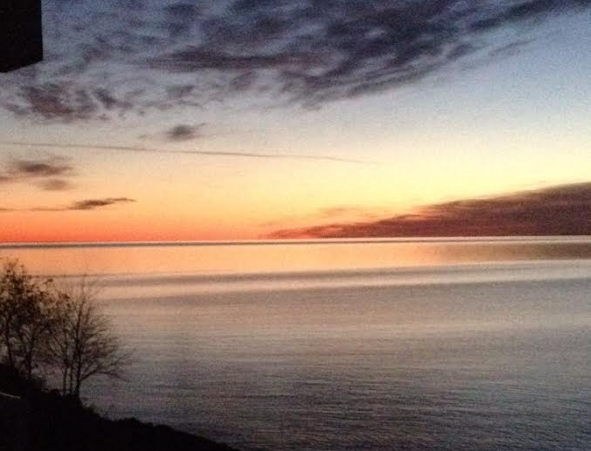
Duluth Sunrise Wednesday
Thank to Greg & Kathy Weidner for this picture from near Duluth. One thing that never gets old is a good sunrise along MN's North Shore!
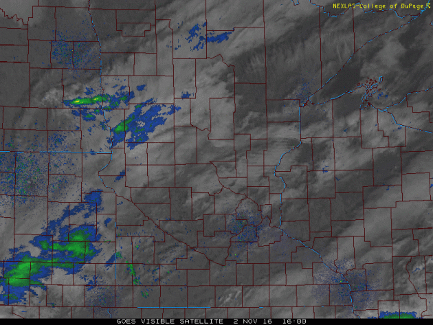
 Wednesday's Sprinkle Threat
Here's the visible satellite loop from Wednesday, which showed a band of clouds working in from the Dakotas that was responsible for a few light showers/sprinkles. Note that this will likely be our last chance of any moisture across the region until late Sunday/Monday.
 Mostly Quiet Weather Outlook
_______________________________________________________________________________
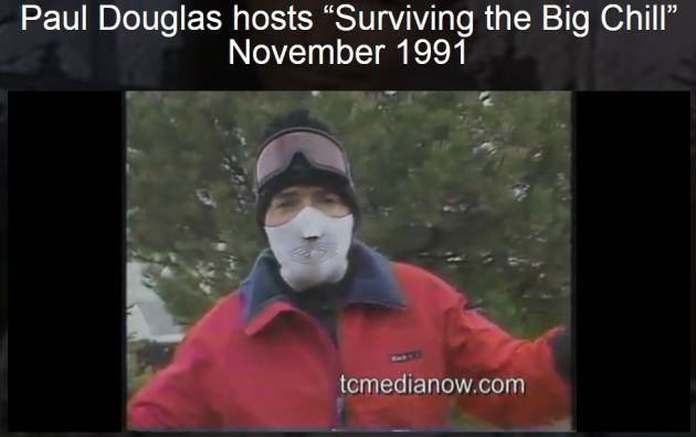
1991 Halloween Blizzard Day 3 Coverage:
If you've been following over the past few days, I've been posting TV news coverage from TCMediaNow.com 25th years ago during the 1991 Halloween Blizzard. I am glad that this stuff still exists. Here's the last bit of video from the coverage, where Paul Douglas hosts "Surviving the Big Chill" after the Halloween Blizzard finally subsided!
In the aftermath of the 1991 Halloween Blizzard Paul Douglas and the KARE 11 weather team (Ellen Ferrara and Ken Barlow) host a half hour special on the causes of severe winter weather and tips on how to survive it. Credit: Paul Douglas
See the full video from TCMediaNow HERE:
 Recounts from the Memorable Blizzard
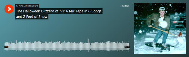
This will be the last day I post this, but if you haven't yet had a chance to listen to this audio from KFAI's MinneCulture, it's pretty good. There are a number of great stories and interviews from during the 1991 Halloween Blizzard.
“How can you forget the one Halloween in your life that came with two feet of snow? KFAI’s Britt Aamodt was studying biology at Gustavus Adolphus College when a record snowstorm blasted its way into her life. She wasn’t alone in experiencing the legendary Halloween Blizzard of 1991, a storm that closed schools, shuttered stores and workplaces and left an indelible memory on those that experienced it. (Photo byPeter Boulay)”
LISTEN HERE:
Thank to Greg & Kathy Weidner for this picture from near Duluth. One thing that never gets old is a good sunrise along MN's North Shore!
Here's the visible satellite loop from Wednesday, which showed a band of clouds working in from the Dakotas that was responsible for a few light showers/sprinkles. Note that this will likely be our last chance of any moisture across the region until late Sunday/Monday.
Here's the weather outlook from Thursday to Monday, which shows mostly quiet conditions for an extended period. After a few light rain showers or sprinkles on Wednesday, the next best chance of any light rain doesn't move in until PM Sunday/Monday.
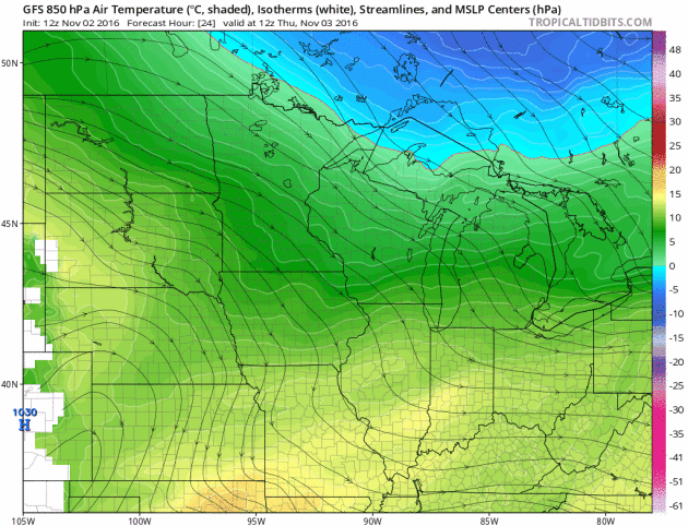
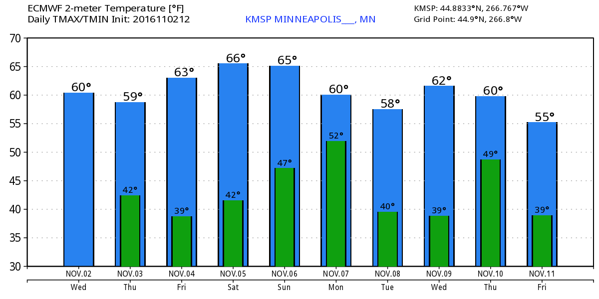
Warm Temps Continue
The temperature loop in the lower to middle part of the atmosphere shows mostly mild temperatures continuing across the Upper Midwest from Thursday to Sunday. Note that only a brief blob of cooler air drifts through the Great Lakes Region. Much of the region will remain warmer than average over the next several days.
_______________________________________________________________________________
If you've been following over the past few days, I've been posting TV news coverage from TCMediaNow.com 25th years ago during the 1991 Halloween Blizzard. I am glad that this stuff still exists. Here's the last bit of video from the coverage, where Paul Douglas hosts "Surviving the Big Chill" after the Halloween Blizzard finally subsided!
In the aftermath of the 1991 Halloween Blizzard Paul Douglas and the KARE 11 weather team (Ellen Ferrara and Ken Barlow) host a half hour special on the causes of severe winter weather and tips on how to survive it. Credit: Paul Douglas
See the full video from TCMediaNow HERE:
This will be the last day I post this, but if you haven't yet had a chance to listen to this audio from KFAI's MinneCulture, it's pretty good. There are a number of great stories and interviews from during the 1991 Halloween Blizzard.
“How can you forget the one Halloween in your life that came with two feet of snow? KFAI’s Britt Aamodt was studying biology at Gustavus Adolphus College when a record snowstorm blasted its way into her life. She wasn’t alone in experiencing the legendary Halloween Blizzard of 1991, a storm that closed schools, shuttered stores and workplaces and left an indelible memory on those that experienced it. (Photo byPeter Boulay)”
LISTEN HERE:
_____________________________________________________________________________
Yesterday's sprinkle threat was about as exciting as it's gonna get in the weather department for the next few days. I don't see any major weather systems brewing in the near future and I certainly don't see any significant cold blobs surging south of the international border.
The upper level winds continue to bubble well north into Canada, which will allow well above temps to stay with us until possibly the middle part of November.
Note that our average high at this time of the year is in the upper 40s and our average low is freezing (32 degrees) by Friday! Also, we average a little more than 9 inches of snow during the Month of November.
While you chew on those stats for a bit, I should mention that I am staring at weather maps that look more like September and October. I am waiting for Mother Nature to shake something out of the weather tree, but nothing seems to want to fall.
Enjoy the incredibly warm and quiet while you can. The other shoe HAS to drop at some point, right? Wake me up when it gets interesting.
___________________________________________________
Extended Weather Outlook
WEDNESDAY NIGHT: Lingering clouds. Winds: SW 5. Low: 42.
THURSDAY: Lingering AM clouds, bright PM sun returns, feels more like October. Winds: WNW 5. High: 62.
THURSDAY NIGHT: Clear and quiet. Winds: S 5. Low: 43
FRIDAY: Mostly sunny and mild. Where's November. Winds: W 5. High: 68.
SATURDAY: Warm MN Deer Hunting Opener. Winds: SSE 5. Wake-up: 45. High: 65.
SUNDAY: Hazy PM sun. Showers possible overnight. Winds: S 5-15. Wake-up: 45. High: 64.
MONDAY: Scattered light rain chance. Winds: SW 5-15. Wake-up: 48. High: 60.
TUESDAY: Gradual clearing, cooler wind. Winds: NNW 5-10. Wake-up: 43. High: 56.
WEDNESDAY: Cooler sunshine. Winds: S 5-10. Wake-up: 37. High: 52.
_______________________________
_______________________________
This Day in Weather History
November 3rd
1991: The Great Halloween blizzard ends with a total of 28.4 inches of snow at the Twin Cities.November 3rd
1956: Parts of central Minnesota experience record high low temperatures in the upper forties to the mid-fifties. Minneapolis, Farmington, Chaska, and Gaylord all had high temperatures of 55 degrees Fahrenheit.
1915: One person is killed by lightning during a strong thunderstorm in Chatfield, MN.
________________________________
Average High/Low for Minneapolis
November 2nd
Average High: 49F (Record: 74F set in 2008)
Average Low: 33F (Record: 8F set in 1991)
Average Low: 33F (Record: 8F set in 1991)
Record Snowfall: 4.2" set in 1951
_________________________________
_________________________________
Sunrise/Sunset Times for Minneapolis
November 2nd
November 2nd
Sunrise: 7:55am
Sunset: 5:58pm
Sunset: 5:58pm
*Daylight Lost Since Yesterday: ~2mins & 43sec
*Daylight Lost Since Summer Solstice: ~5hours and 35mins
______________________________________________________________________
*Daylight Lost Since Summer Solstice: ~5hours and 35mins
______________________________________________________________________
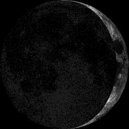
Moon Phase for November 1st at Midnight
3.5 Days Before First Quarter
3.5 Days Before First Quarter
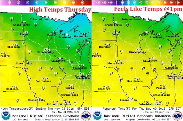
Weather Outlook Thursday
High temperatures on Thursday will be quite warm across much of the Upper Midwest once again. Highs across Minnesota will range from the 60s across the southern part of the state to the 50s across the northern part of the state. This will still be nearly 10F to 15F above average!
High Temperatures From Average Thursday
Here's a look at how much warmer than average we will be on Thursday across the Upper Midwest. Note that much of Minnesota will be 10F to 15F above average, while much of the Dakotas will be nearly 15F to 20F above average.
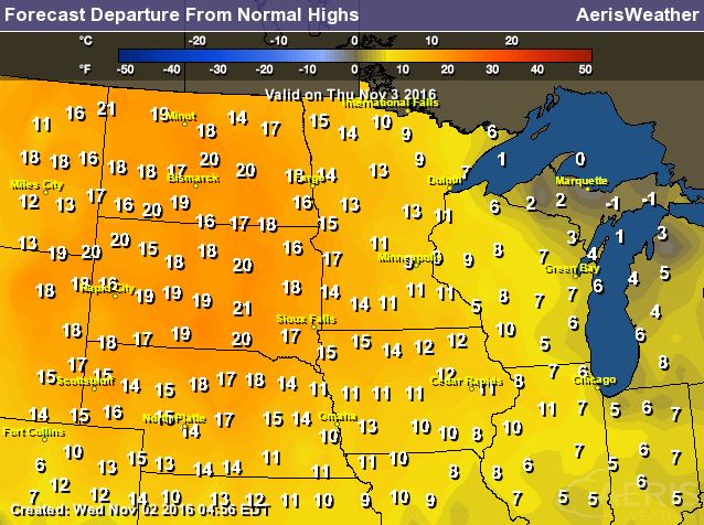
Weather Outlook Thursday
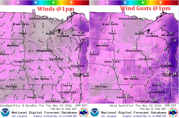
Winds on Thursday will still be quite light across the state and across much of the Upper Midwest for that matter.
Weather Outlook Thursday
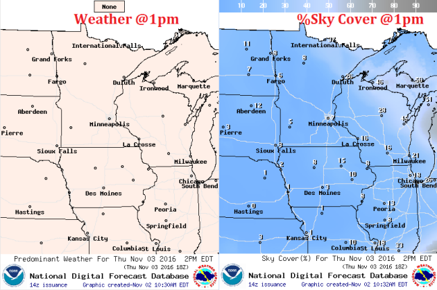
After a cloudier Wednesday, sunshine and quiet weather returns to much of the Upper Midwest on Thursday. Note that we look to stay dry and mostly sunny until late weekend.
___________________________________________________________
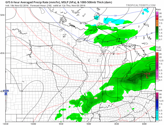
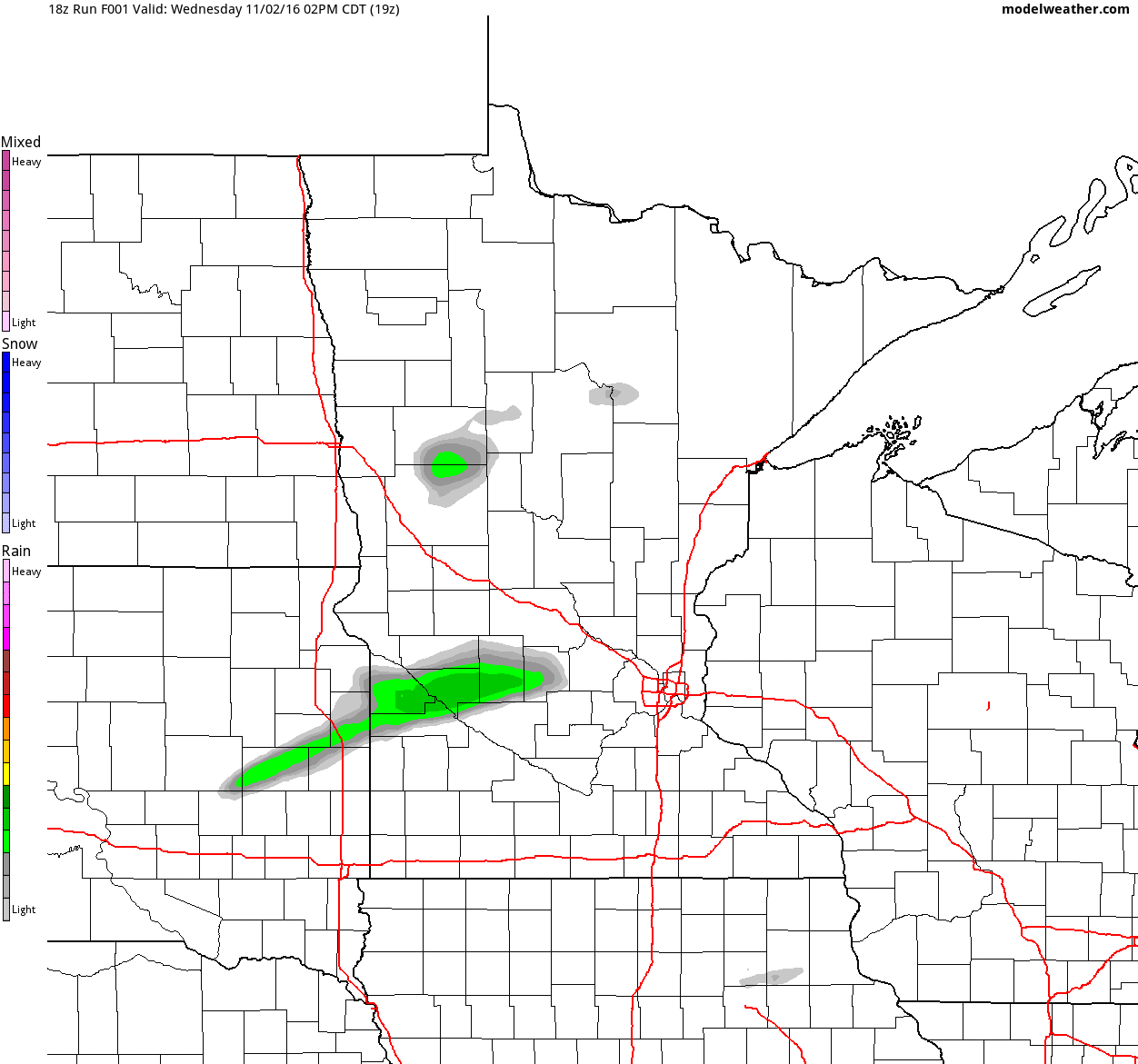
Simulated Radar
The simulated radar from Wednesday to Saturday shows a few spotty sprinkles moving through the region on Wednesday with a few more across light showers lingering across the northeastern part of the state early Thursday.
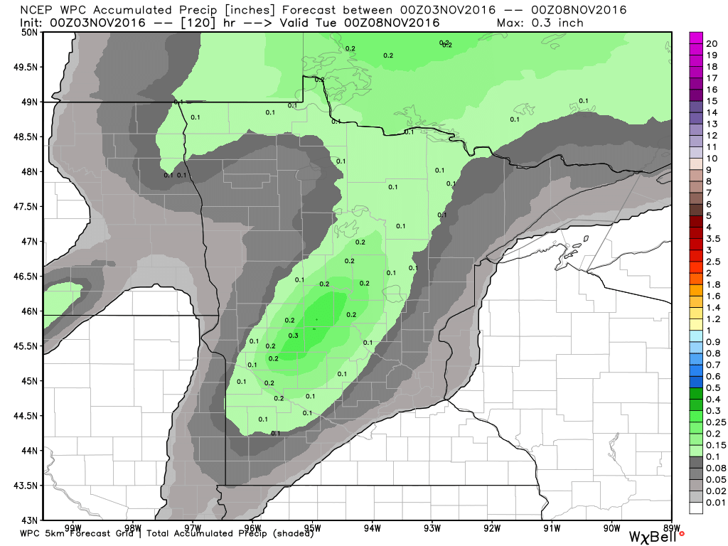
Rainfall Potential
Here's the 5 day rainfall forecast through Monday, which shows a little light rain across the state. Note that the rain won't move in until PM Sunday/Monday, until then, we stay dry.
_______________________________________
Extended Weather Outlook
Temperatures for the rest the week ahead look very mild with temps consistently in the 50s and 60s, which will be well above average. Even into next week, there doesn't appear to be any major cold snaps in sight!
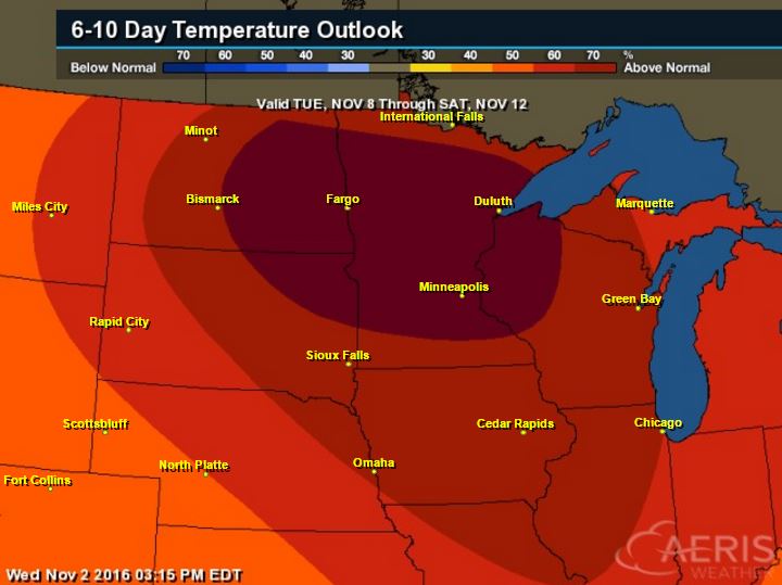
Warm Temperatures Return to Midwest
According to NOAA's CPC, the 6 to 10 day temperature outlook suggests warmer than average temperatures continuing across much of the Upper Midwest as we head through the middle part of November.
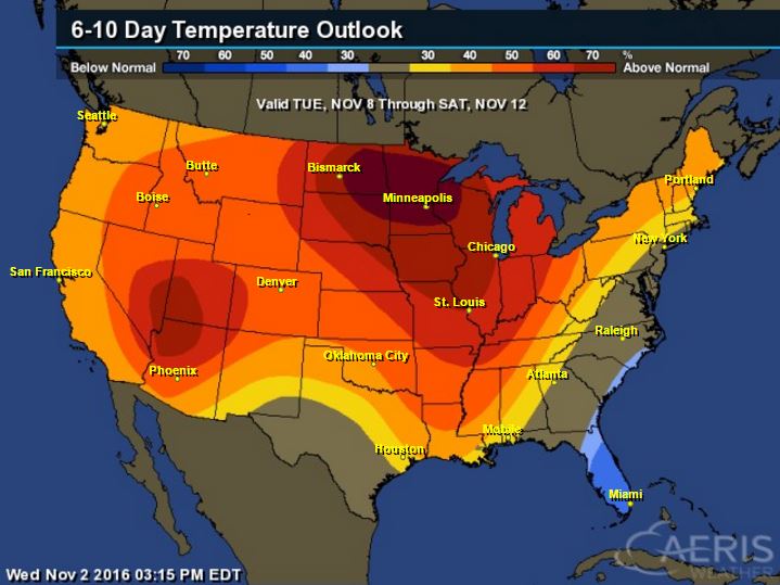
Here's the national temperature outlook from November 8th - 12th, which shows warmer than average conditions across much of the nation.
__________________________________________
National Weather Outlook
A frontal boundary sliding through the Central US on Wednesday will continue moving toward the Eastern US on Thursday. There may be a few heavy pockets of rain in the Northeast, but lingering moisture will continue near the Four-Corners Region through the end of the week.
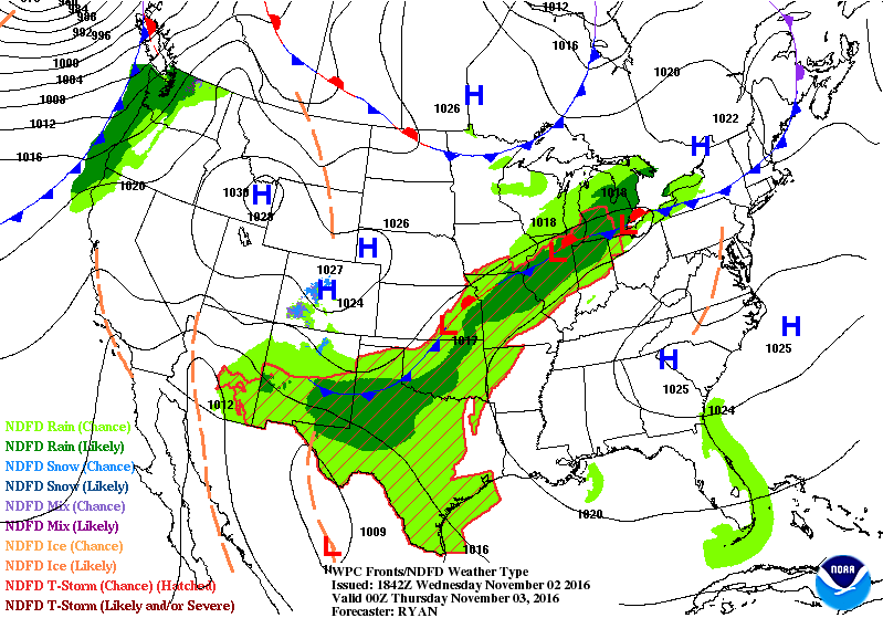
Precipitation Outlook
According to NOAA's WPC, heavy moisture will continue across the extreme northwestern part of the US, while some 2" to near 4" amounts will be possible from New Mexico to western Texas. 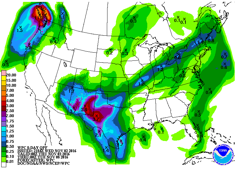 _____________________________________________________________________________
"What if you could understand climate models better by eating them?"_____________________________________________________________________________"Look, I’m with you: If we spend one more second talking about how we talk about climate change, we’ll be forcibly evicted to Mars to start all over. But what if, instead of talking or reading or writing, there were a better way to, well, digest our information about climate change? That’s the goal of the latest plan put forward by Jonathon Keats, experimental philosopher and artist. Last we heard from Keats, he was devising a fairly bizarre geoengineering proposal to address climate change: squishing all the continents together. Now, he’s back with an idea to help illustrate the mechanisms by which our planet warms: eating climate models via “anthropocenic sorbets.” He calls the process “data gastronification.” We talked to Keats about his project, which will be featured at the STATE Festivalin Berlin from November 4–5 (not-so-incidentally, the day the Paris Climate Treaty goes into effect)."
See more from Climate Central HERE:

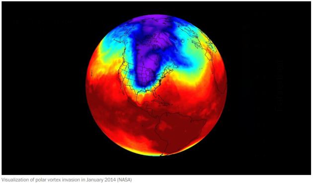
____________________________________________________________________________"Polar vortex shifting due to climate change, extending winter, study finds"
"Global warming could be making winters in eastern North America even longer, according to a new study. The study finds that, because of sea ice loss in the Arctic, the polar vortex is shifting and temperatures are turning colder during March. [Arctic sea ice is at a record low and could, in spurts, disappear within our lifetimes] The polar vortex is the zone of frigid air that encircles the Arctic and is most pronounced during winter. There are actually two different polar vortexes: a stratospheric polar vortex, about 65,000 feet above the earth’s surface, and a tropospheric polar vortex about 18,000 to 30,000 feet up. Weather forecasters most frequently refer to the tropospheric vortex, which sometimes breaks apart in winter and causes cold snaps when the broken fragments plunge towards the mid-latitudes. This study, however, focuses on the effects of sea ice changes on the stratospheric polar vortex, whose behavior can have important effects on mid-latitude weather, but more indirectly. [The battle over the polar vortex, and how it should be settled] The study published in Nature Climate Change last week found the stratospheric polar vortex has changed position while weakening over the past three decades. The net result has been to increase delivery of cold air into parts of Eurasia and North America, particularly in late winter and early spring. It’s counterintuitive, but when the polar vortex is weak, it’s more unstable, and cold air outbreaks from the Arctic southward toward the mid-latitudes become more likely. (When it’s strong, the cold air is more contained in the Arctic and the mid-latitudes are milder.)"
See more from WashingtonPost HERE:
____________________________________________________________________________

No comments:
Post a Comment