36 F. high in St. Cloud Tuesday.
31 F. average high on November 29.
35 F. high on November 29, 2015.
November 30, 2006: Lake effect snow occurs downwind of the larger lakes in Minnesota. Northwest winds from 8 to 12 mph accompanied an air mass in the single digits. This moved over lakes with water temperatures near 40 degrees. A cloud plume from Mille Lacs stretched all the way to Siren Wisconsin. Snow from Ottertail Lake and Lake Lida reduced visibilities at Alexandria to a few miles. Even some low clouds formed from Lake Minnetonka and were observed at Flying Cloud Airport.
November 30, 2000: A surface low pressure system moves into extreme southwestern Minnesota from South Dakota. The heaviest snow reported was in the 6 to 8 inch range, and fell in a narrow band just southwest of the Minnesota River in and around the Canby (Yellow Medicine County) and Madison (Lac Qui Parle County) areas. Northeast winds rising out of the Minnesota river valley up the slopes of the Buffalo Ridge in southwest Minnesota helped enhance snowfall amounts. The northeasterly winds between 10 and 20 mph were responsible for producing visibilities in the one to two mile range.
November 30, 1991: A storm dumps 14 inches of snow in the Twin Cities in about 12 hours.
November 30, 1896: Bitterly cold temperatures are reported across Minnesota. A low of 45 below zero occurs at the Pokegama Dam.
Snowfall Inflation - Major Storm Next Week?
A single snowstorm can drop up to 39 million tons of snow. Which is why, as a profession, meteorologists tend to over-predict snow. The biggest sin a forecaster can commit is missing a tornado - or predicting flurries, only to wake up to a FOOT of flurries.
That's why it pays to take all the snowfall predictions on TV, radio, internet and your favorite app, and divide by 2. That will be closer to the mark.
One other timeless truth: if I predict 3-6 inches, chances are you'll only hear 6 inches.
Some of our biggest snowstorms have spun up on the leading edge of fresh outbreaks of bitter, Canadian air. One such heavy snow potential is brewing for the middle of next week. It's too early to get too excited, but ECMWF guidance hints at a plowable to crippling snowfall for Minnesota next Wednesday and Thursday with near-blizzard conditions. Confidence levels are still very low - keep checking in for the latest.
A slushy coating is possible tonight but skies dry out for the weekend.
The coldest air since mid-February arrives late next week, possibly preceded by a big pile of white.
* ECMWF forecast map above valid next Thursday morning, December 8, courtesy of WSI.
Who Gets The Most Blizzards in the USA? Western Minnesota and the Dakotas: take a bow. Here are a couple of excerpts from an interesting story at The Buffalo News: "...This maximum distribution is approximately the same now, except the number of verified blizzards has increased in the United States. Some of that may be due to climate factors or improved reporting or, in my opinion, the removal of the temperature requirement; we just don’t know...The high frequency over the northern and high plains is more closely tied to the average path taken by deep winter cyclones/low-pressure systems, placing that swath of the country most often in the colder quadrant of those storms, with howling winds and heaviest snow..."
Map credit: "Climatology of Blizzards in the Conterminous United States, 1959–2000."
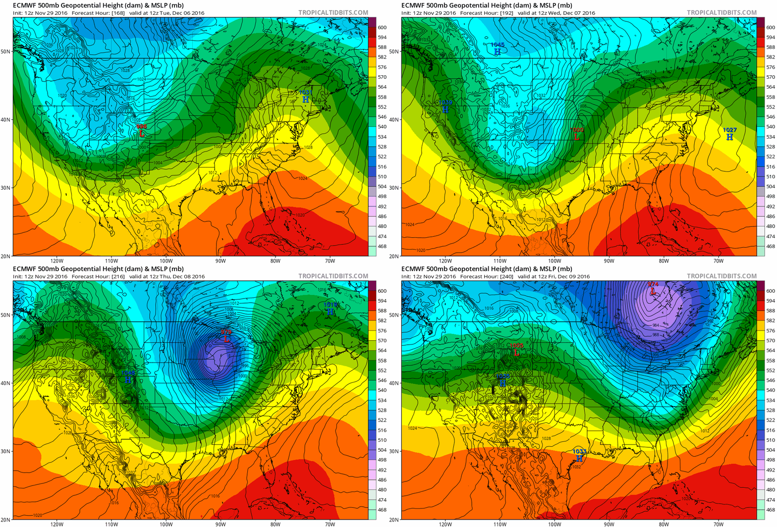
ECMWF Forecast Next Tuesday - Friday. This potential event is still a week away, so this is more of a curiosity than a forecast. Odds are future model runs will shift, but for now the European tries to spin up a deep (979mb) storm with near-blizzard conditions for the Midwest next Wednesday and Thursday. Will it verify? The Euro is good, but hardly infallible. My gut: 1 in 3 chance of a full-blown blizzard.
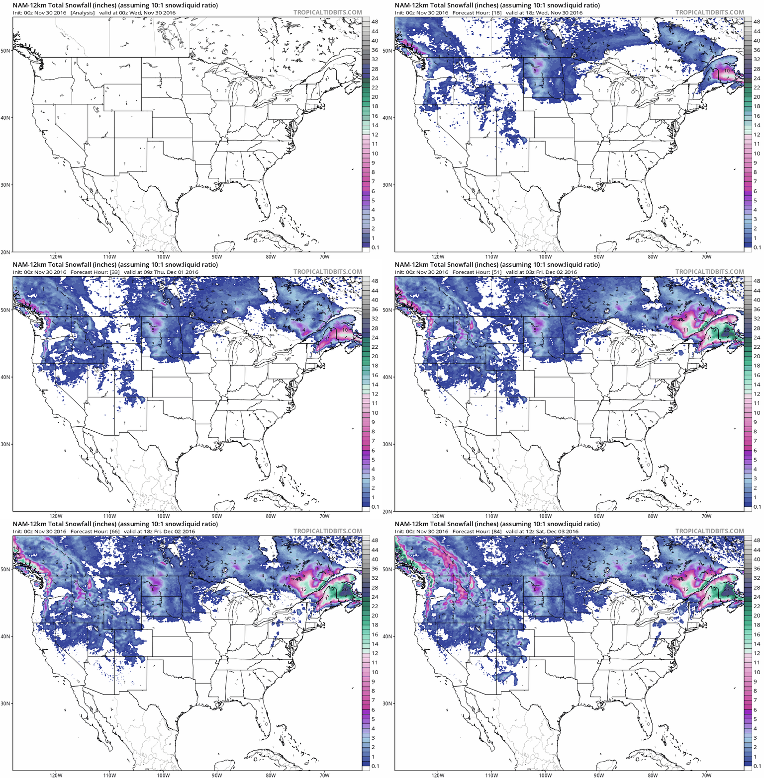
84-Hour Snowfall. Here is NOAA's 12km snowfall product showing total accumulation through Saturday morning at 12z. Heaviest amounts (15-20") are projected to fall on Maine, with plowable snows for the Dakotas, the Rockies and highest terrain of the Pacific Northwest. Map credit: Tropicaltidbits.com.
Forget Inches, There Are 3 Categories of Snowstorms. My favorite college professor told us to "forget about inches", since we can't predict snow down to the inch, and instead classify storms into 3 categories: nuisance (enough to coat roads and sidewalks but travel isn't impacted too badly), "plowable" (just as the and word implies, enough snow to shovel, scrape and plow) and crippling (where everything stops - traffic is paralyzed and business pretty much shuts down). I've been borrowing the scale since 1983 at KARE-11. It has stood the test of time. Thank you Dr. Cahir at Penn State.
"Thunderstorm Asthma" Kills 8 in Australia.
The death toll is up to 8 from the freakish combination of pollen and
thunderstorm moisture and wind; here's an excerpt of an update at The New York Times: "...Mr. McGann was one of thousands of people in Melbourne having an attack of thunderstorm asthma.
They flooded the city’s emergency rooms, swamped ambulance call lines
and joined lines around pharmacies during six hours on Nov. 21. All were
struggling for breath. About 8,500 people went to hospitals. Eight have
died, and one remains in intensive care more than a week after a
thunderstorm surged across Melbourne, carrying pollen that strong winds
and rain broke into tiny fragments. Perennial ryegrass seeds were swept
up in whorls of wind and carried from four million hectares of
pasturelands (about 9.9 million acres) that lie to Melbourne’s north and
west. If broken into fragments, they are so fine that they can be
inhaled..." (Image credit: UK Daily Record).
11 Ways The Atmosphere Went Bonkers This October That You Probably Didn't Notice. Here's an excerpt and a partial list from a story at Yahoo! Finance: "...Each month, the National Oceanic and Atmospheric Association (NOAA) releases a list of some of the most significant trends in the climate from the past month. Here are some of the most drastic things that took place this October:
- The global average temperature was 1.31 degrees Farenheit above the 20th-Century average of 57.1 — tied with 2003 for the third hottest October ever recorded.
- In the Arctic, 980,000 square miles of sea ice (an area larger than Texas and Alaska combined) went missing. That left Earth with a whopping 28.5% less Arctic ice than the 1981-2010 average, or the lowest levels ever recorded.
- The Antarctic saw sea ice levels that were 290,000 square miles below average — 4% below the 1981-2010 average, or the second-lowest October ever.
- The continental US experienced its third-warmest October in the 122-year record.
- Alaska experienced its driest October since records began in 1925.
- Finland experienced its driest October since national records began in 1961 and Norway experienced its fourth-driest since records began in 1900..."

Many 500-Year or 1,000-Year Floods Reported This Year. Here's a nugget from a story at Weather or Not and CDAPress.com: "It’s almost hard to believe, but areas that are currently reporting major drought conditions experienced massive flooding earlier this year. Normally, we see these huge 500-year or 1,000-year flood events less than once per year. For 2016, there have been nearly a dozen events, which indicates that our cycle of Wide Weather “Extremes” is still going strong with no signs of letting up anytime soon. Most of the big flood events were east of the Rockies. In early June, Houston reported 22 inches of rain, which was a 500-year event. Dallas picked up 16 inches of rain, also a 500-year flood..."
File photo: David Gatley, FEMA.
On Virginia's Vulnerable Coast, Fear of Flooding On The Rise. The Norfolk/Tidewater region of Virginia is nearly as vulnerable to rising seas as south Florida. ABC News reports: "...Experts
warn that flooding will likely increase in Virginia's Hampton Roads
region, where Virginia Beach and six other cities are clustered on or
near the state's low-lying coast. The land is sinking and the sea is
rising at the highest rate on the East Coast, they say. Global warming
threatens to draw more intense rain storms up the Eastern Seaboard.
Fears are growing that this historically prime location for military
installations threatens livelihoods as much as it sustains them. The
Atlantic meets the mouth of the Chesapeake Bay here along with the
confluence of three rivers. The world's largest naval base sits in
Norfolk, nearby. A commercial port, ship builders and a railroad help
fuel the economy..." (File image credit here).
Photo credit: "Calvin Williamson, a professor of math in the Fashion Institute of Technology’s School of Liberal Arts, teaches ‘Predictive Analytics for Planning and Forecasting,’ a new class." Photo: Caitlin Ochs for The Wall Street Journal.
Graphic credit: International Energy Agency
Photo credit: "A female Aedes aegypti mosquito feeds from a researcher at Rockefeller University." (Alex Wild).
Another U.S. City Commits To 100% Renewable Energy. Details via Solar Industry: "The St. Petersburg, Fla., City Council has formally approved the city’s commitment to transition to 100% clean, renewable energy. According to the Sierra Club, St. Petersburg represents the first city in Florida and the 20th city in the U.S. to make such a commitment. In a unanimous vote, the City Council Committee of the Whole has allocated $250,000 of BP settlement funds from the 2010 Deepwater Horizon oil spill to an Integrated Sustainability Action Plan (ISAP), which will chart a roadmap to 100% renewable energy in St. Petersburg..."

Map credit: "An image from the 1951 Compendium of Meteorology showing front activity, based on Bjerknes’ model." Internet Archive/Public Domain

TODAY: Rain/snow mix, wet roads during the day. Winds: NW 8-13. High: near 40
WEDNESDAY NIGHT: Wet snow, coating to an inch on some lawns. Low: 33
THURSDAY: Clouds linger, few flurries around. Winds: NW 8-13. High: 38
FRIDAY: Sunny peeks, seasonably chilly. Winds: W 7-12. Wake-up: 28. High: 36
SATURDAY: Mix of clouds and sun, dry sky. Winds: S 5-10. Wake-up: 24. High: 38
SUNDAY: Mostly cloudy, flurries or sprinkles. Winds: W 10-15. Wake-up: 30. High: near 40
MONDAY: Mostly cloudy, milder than average again. Winds: S 10-20. Wake-up: 31. High: 45
TUESDAY: Sloppy mix may develop. Winds: N 10-15. Wake-up: 34. High: 37
Climate Stories...

Photo credit: "Pope Francis greets Stephen Hawking (R), theoretical physicist and cosmologist, during a meeting with the Pontifical Academy of Sciences in Vatican, November 28, 2016." Osservatore Romano/Handout via Reuters.
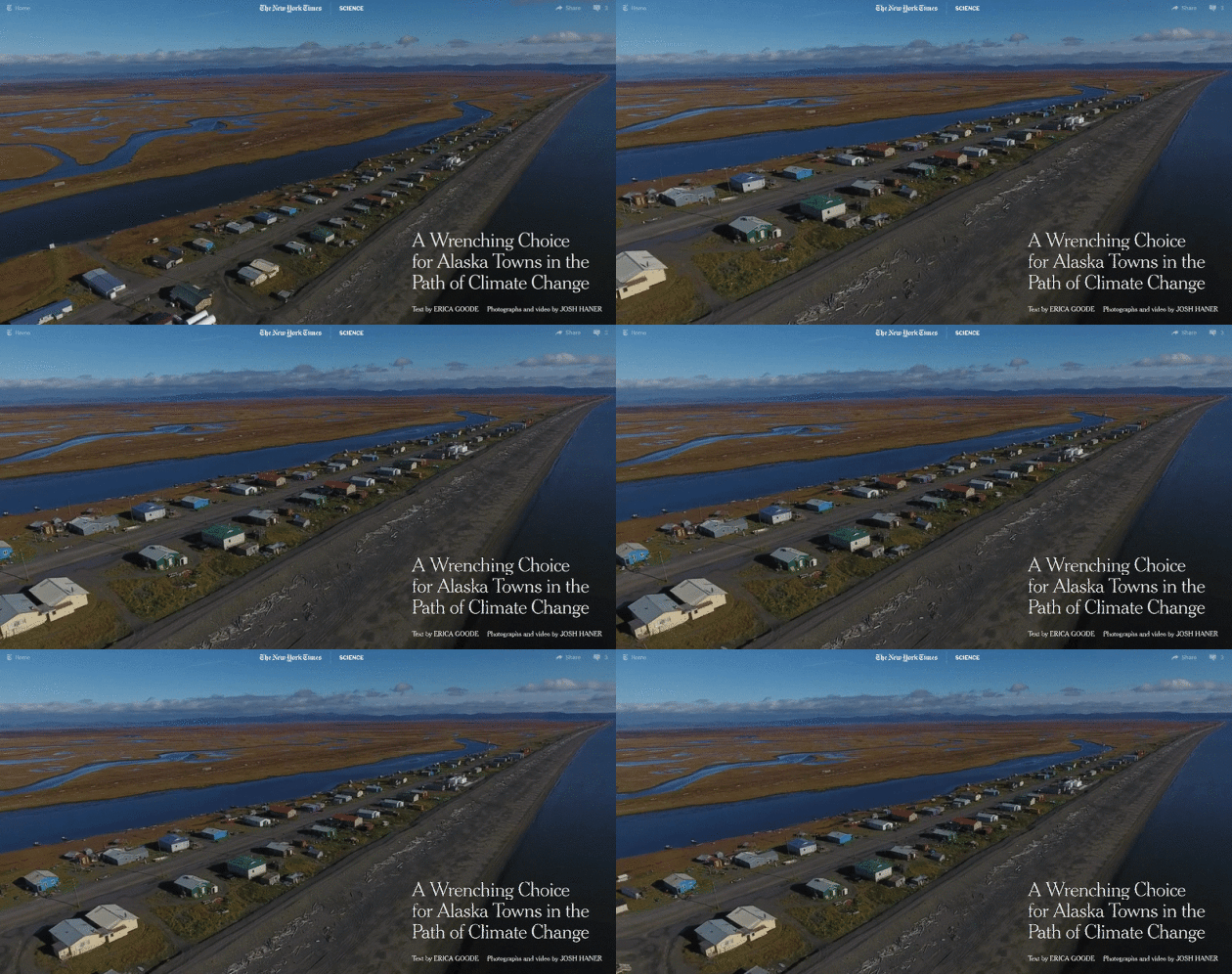
A Wrenching Choice For Alaskan Towns In The Path of Climate Change. America has already seen its first climate refugees, in Louisiana and Alaska. Here's an excerpt from The New York Times: "...With
its proximity to the Arctic, Alaska is warming about twice as fast as
the rest of the United States and the state is heading for the warmest
year on record. The government has identified at least 31 Alaskan towns
and cities at imminent risk of destruction, with Shaktoolik ranking
among the top four. Some villages, climate change
experts predict, will be uninhabitable by 2050, their residents joining
a flow of climate refugees around the globe, in Bolivia, China, Niger
and other countries. These endangered Alaskan communities face a choice.
They could move to higher ground, a wrenching prospect that for a small
village could cost as much as $200 million. Or they could stand their
ground and hope to find money to fortify their buildings and shore up
their coastline..."
Photo credit:
File image: Oxnard Chamber of Commerce.
Design Bridges For a Wetter Climate. If we're going to rebuild infrastructure, why not make everything we do more weather-proof and climate-resistant, technologies we can export to the rest of the world? Here's an excerpt of an Op-Ed at The Des Moines Register: "We’ve seen this picture too often recently: bridges and roadways overtopped by floodwaters. Such infrastructure, designed to last 100 years based on historical data, is experiencing damage at more frequent intervals. Precipitation, as part of Iowa’s climate, clearly has changed. To build roadways and bridges to last 100 years into the future, should we inform design by augmenting historical data with future scenarios from climate models? Climate scientists consider the early 1970s to be approximately when global climate records began showing a clear influence of increases in greenhouse gases. Although varying widely from year to year, Iowa’s statewide annual precipitation was remarkably constant from 1893 through 1970, decreasing 0.04 inches over 98 years. However, between 1971 and 2016, the annual total increased by 3.7 inches. For those years, the increase from April through June has been 4.2 inches..."
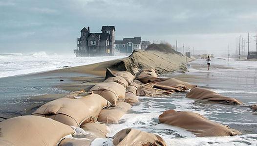
Photo credit: "An Inuit village in Greenland is pictured in this September 2013 handout photo provided by Ida Moltke. New research by the Arctic Council shows how unprecedented high temperatures and rapid ice melt in the Arctic are driving communities to tipping points of survival." Ida Moltke/Handout/Reuters/File.
Photo credit: Wikipedia.
No comments:
Post a Comment