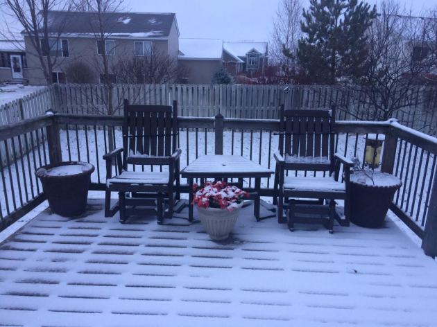
Snowy Start on Sunday
Many of us woke up to a slushy coating of snow on Sunday after a quick moving system rolled overnight Saturday/AM Sunday. It wasn't much, but it cause several accidents and spin outs as area roads became very slippery. Unfortunately for snow lovers, much of the snow will melt due to warm temperatures continuing on Sunday and Monday. In fact, temps on Monday will warm into the low/mid 40s across parts of southern MN.

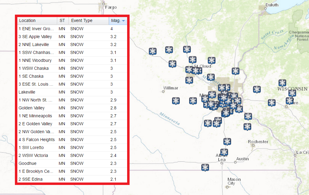
 Snowfall Totals
Here's a look at snowfall tallies from across the region. There were several 1" to 3" tallies, but there was also a 4" report from near Inver Grove Heights. Thanks to above freezing temps during the day Sunday, much of that snow melted.
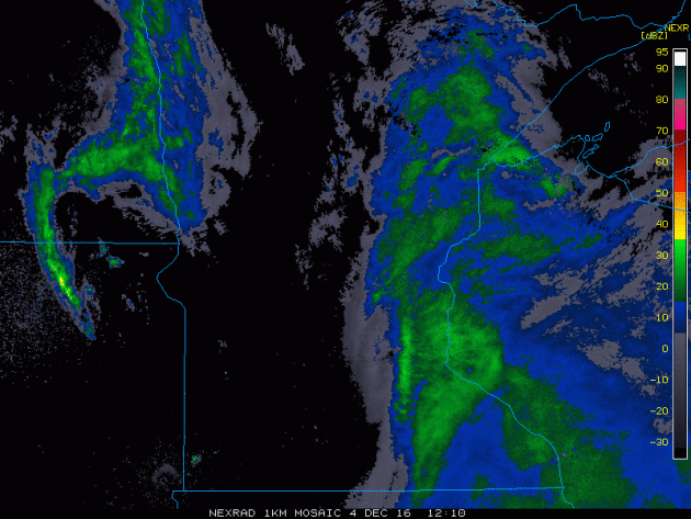
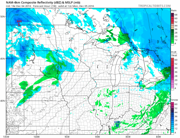
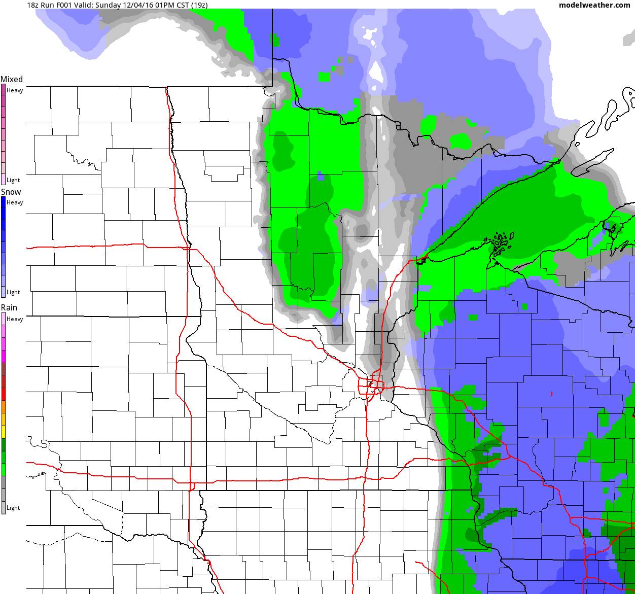
Radar Loop of Snow Ending AM Sunday
Here's the radar loop from early Sunday as the snow was ending across the Twin Cities. Heavier snow up to 1" to 3" fell across parts of the region, while just a light coating was found farther west.
 ________________________________________________________Big Snow on the Big Island
Hawaii's highest peak could get up to another foot of snow Sunday, on top of the 2 feet that have fallen since Thursday, the National Weather Service says. A winter storm warning is in effect for the summits of Mauna Loa and Mauna Kea through Saturday evening. “Then we’re expecting another round on Sunday and Sunday night,” said Matthew Foster, a staff meteorologist with the National Weather Service in Honolulu. Snow on the peaks is not uncommon in the colder months of the year, though deep snow is rare. “We’ll probably see three to five snow events a year during the cold season. Some years we might not get any, some years we might get more,” said Foster. The only other area of Hawaii that gets snow with any regularity is the Haleakalā volcano on Maui, which at about 10,000 feet gets snow once every five years or so, he said."
See more from USA Today HERE:
"In this image made from webcam video provided by Canada-France-Hawaii Telescope, the CFHT telescope on the summit of Mauna Kea on Hawaii's Big Island is covered in snow on Thursday, Dec. 1, 2016. The National Weather Service in Honolulu has issued a winter storm warning for the summits of Hawaii's Big Island as wind and snow engulf the high peaks. (Canada-France-Hawaii Telescope via AP)"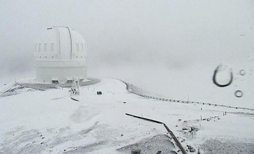
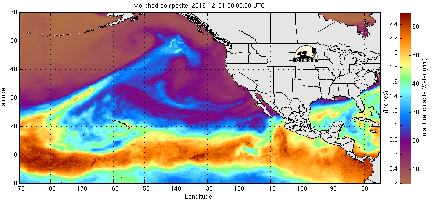
Pacific Moisture Moves into the Pacific Northwest
Here's the Eastern Pacific precipitable water loop that shows heavier moisture from the Pacific moving into the West Coast in a few different waves. These rounds of heavier moisture have been responsible for heavier coastal rains and high elevation snow. Another one of these storms is moving through the Pacific Northwest now with heavier snow possible through early next week.
Another Surge of Heavier Pacific Moisture
Here's a look at the next storm system moving through the region through the early part of next week. Note that areas along the coast and in the lower elevations will likely see rain, while those in the higher elevations will see snow. Some spots could see 1ft to 2ft by early next week.
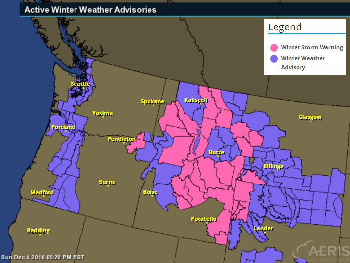
.gif) Winter Weather Headlines
Winter Weather Headlines
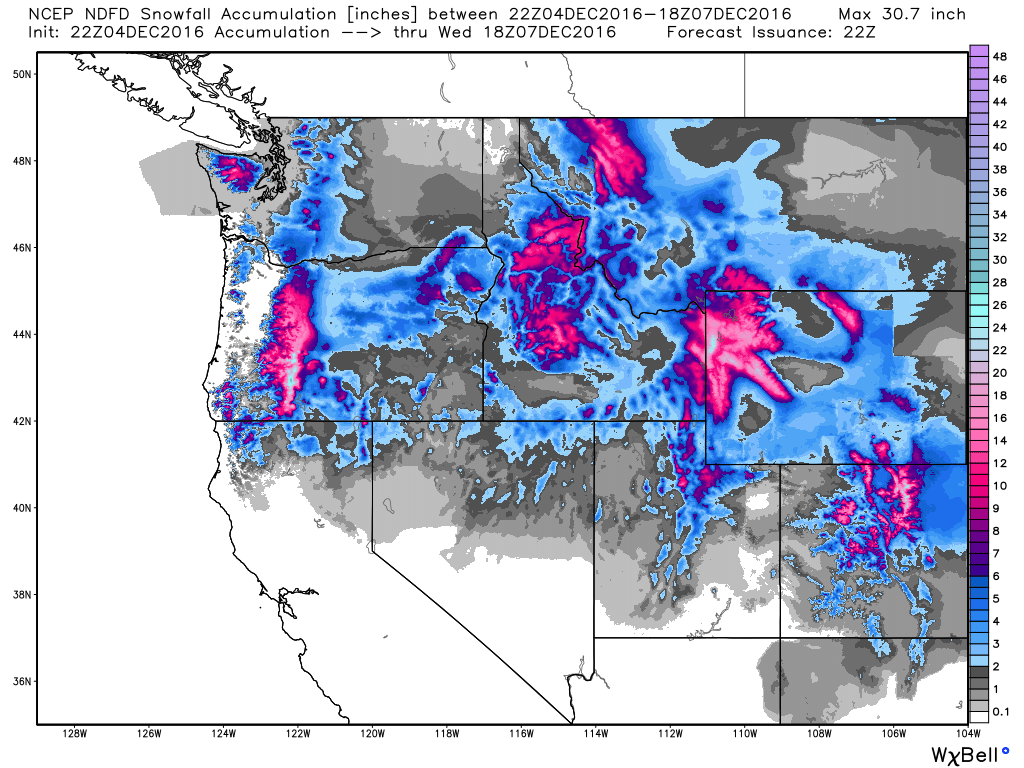
Snow in the Northwest
Here's the snowfall potential through midday Midday, which shows fairly significant tallies across the Cascade range and across much of the northern Rockies. Some spots could see up to 1ft. to 2ft. through early next week.
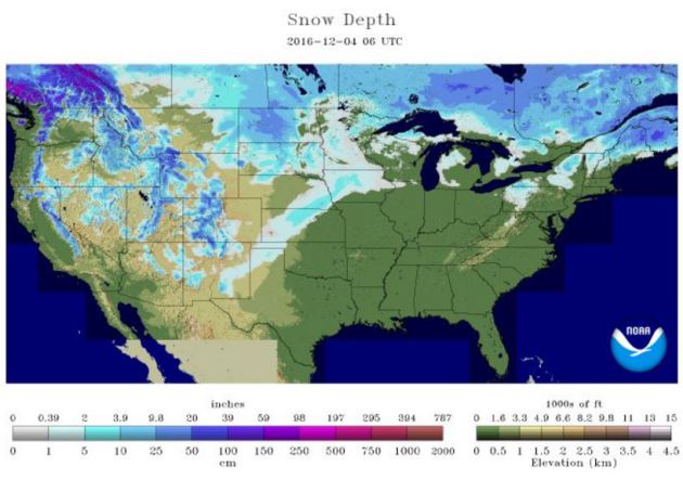
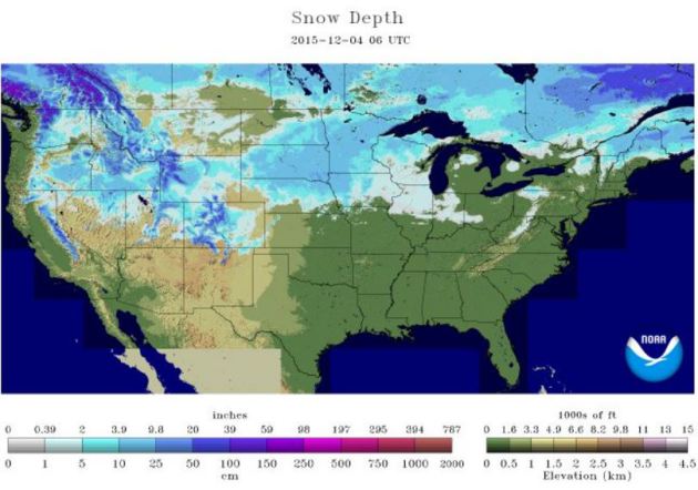
According to NOAA's NOHRSC, 27.8% of the nation was covered up in snow as of December 4th. Last year at this time, 33.0% of the nation was covered up by snow!
 __________________________________________________________________________________
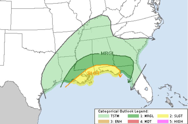 Severe Threat Tuesday
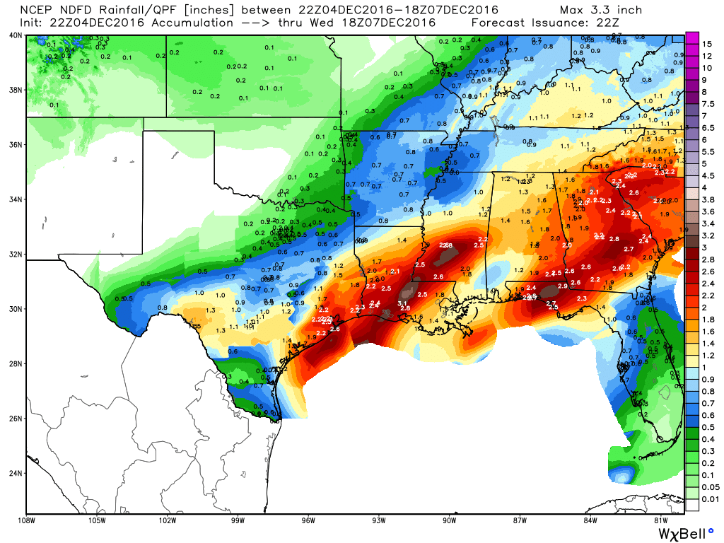
Heavy Southern Rain
__________________________________________________________________
Somewhat Active Pattern With Colder Temps Ahead.
Many of us woke up to a slushy coating of snow on Sunday after a quick moving system rolled overnight Saturday/AM Sunday. It wasn't much, but it cause several accidents and spin outs as area roads became very slippery. Unfortunately for snow lovers, much of the snow will melt due to warm temperatures continuing on Sunday and Monday. In fact, temps on Monday will warm into the low/mid 40s across parts of southern MN.
Here's a look at snowfall tallies from across the region. There were several 1" to 3" tallies, but there was also a 4" report from near Inver Grove Heights. Thanks to above freezing temps during the day Sunday, much of that snow melted.
Radar Loop of Snow Ending AM Sunday
Here's the radar loop from early Sunday as the snow was ending across the Twin Cities. Heavier snow up to 1" to 3" fell across parts of the region, while just a light coating was found farther west.
Hawaii's highest peak could get up to another foot of snow Sunday, on top of the 2 feet that have fallen since Thursday, the National Weather Service says. A winter storm warning is in effect for the summits of Mauna Loa and Mauna Kea through Saturday evening. “Then we’re expecting another round on Sunday and Sunday night,” said Matthew Foster, a staff meteorologist with the National Weather Service in Honolulu. Snow on the peaks is not uncommon in the colder months of the year, though deep snow is rare. “We’ll probably see three to five snow events a year during the cold season. Some years we might not get any, some years we might get more,” said Foster. The only other area of Hawaii that gets snow with any regularity is the Haleakalā volcano on Maui, which at about 10,000 feet gets snow once every five years or so, he said."
See more from USA Today HERE:
"In this image made from webcam video provided by Canada-France-Hawaii Telescope, the CFHT telescope on the summit of Mauna Kea on Hawaii's Big Island is covered in snow on Thursday, Dec. 1, 2016. The National Weather Service in Honolulu has issued a winter storm warning for the summits of Hawaii's Big Island as wind and snow engulf the high peaks. (Canada-France-Hawaii Telescope via AP)"
Pacific Moisture Moves into the Pacific Northwest
Here's the Eastern Pacific precipitable water loop that shows heavier moisture from the Pacific moving into the West Coast in a few different waves. These rounds of heavier moisture have been responsible for heavier coastal rains and high elevation snow. Another one of these storms is moving through the Pacific Northwest now with heavier snow possible through early next week.
Another Surge of Heavier Pacific Moisture
Here's a look at the next storm system moving through the region through the early part of next week. Note that areas along the coast and in the lower elevations will likely see rain, while those in the higher elevations will see snow. Some spots could see 1ft to 2ft by early next week.
...WINTER STORM WARNING IN EFFECT THRU 11 AM MST MONDAY...

THE NATIONAL WEATHER SERVICE IN MISSOULA HAS ISSUED A WINTER
STORM WARNING FOR HEAVY SNOW AND BLOWING SNOW...WHICH IS IN
EFFECT FROM MIDNIGHT TONIGHT TO 11 AM MST MONDAY. THE WINTER STORM
WATCH IS NO LONGER IN EFFECT.

* IMPACTS/TIMING: SNOW WILL CONTINUE FOR TONIGHT AND SNOW
  INTENSITIES WILL INCREASE DURING THE DAY SUNDAY. THE COMBINATION
  OF ACCUMULATING SNOW AND WIND, VISIBILITY COULD BE GREATLY
  REDUCED, ESPECIALLY OVER MARIAS PASS. A PERIOD OF MODERATE TO
  HEAVY SNOW AND GUSTY WINDS IS LIKELY SUNDAY AFTERNOON AND EVENING
  WITH THE COLD FRONT. ALL OF THESE IMPACTS WILL CREATE HAZARDOUS
  TRAVEL CONDITIONS SUNDAY THROUGH THE FIRST PART OF MONDAY.

* SNOW ACCUMULATIONS SUNDAY THROUGH MONDAY: 10 TO 14 INCHES WITH
  ISOLATED HIGHER AMOUNTS IN THE MOUNTAINS AND MARIAS PASS.

* WINDS: GUSTY WEST NORTHWEST WINDS OF 30 TO 40 MILE PER HOUR
  POSSIBLE FOR MARIAS PASS.
Snow in the Northwest
Here's the snowfall potential through midday Midday, which shows fairly significant tallies across the Cascade range and across much of the northern Rockies. Some spots could see up to 1ft. to 2ft. through early next week.
National Snow Cover
More Heavy Rain in the South/Southeast
Take a look at the heavy potential across the southern and southeastern US through the middle part of the week! Widespread heavy rainfall could lead to areas of flooding over the next few days, especially over eastern Texas and the Lower Mississippi Valley. Not only will heavy rain be possible, but a few strong to severe storms may be possible into early next week as well.
Severe Threat Monday
...SUMMARY...
   A FEW STRONG TO SEVERE STORMS ARE POSSIBLE MONDAY AFTERNOON INTO
   MONDAY NIGHT OVER SOUTHERN PORTIONS OF THE GULF COAST STATES.
   DAMAGING WIND IS THE PRIMARY THREAT...ALTHOUGH SOME HAIL IS POSSIBLE
   WITH ACTIVITY NORTH OF THE WARM FRONT.

   ...GULF STATES...

   LATEST SHORT-RANGE MODEL GUIDANCE CONTINUES TO SUGGEST A STRONG
   SOUTHERN-STREAM SHORT-WAVE TROUGH WILL EJECT ENEWD ACROSS NORTHERN
   MEXICO INTO THE LOWER MISSISSIPPI VALLEY BY 06/00Z.  500MB SPEED MAX
   WILL INCREASE TO NEAR 80KT AS THIS FEATURE LIFTS NEGATIVELY TILTED
   INTO THE TENNESSEE VALLEY BY SUNRISE TUESDAY MORNING.  IN RESPONSE
   TO THIS FEATURE...LOW-LEVEL TRAJECTORIES ACROSS THE GULF BASIN WILL
   AID IN THE NWD ADVANCEMENT OF A SURFACE WARM FRONT...BUT TRUE
   MARITIME AIR IS NOT EXPECTED TO MOVE APPRECIABLY INLAND.  04/12Z NAM
   SUGGESTS HIGHER THETA-E AIR SHOULD HOLD NEAR THE COAST AND FOR THIS
   REASON HAVE SUPPRESSED THE SLGT RISK A BIT CLOSER TO THE GULF WHERE
   BUOYANCY WILL BE SOMEWHAT HIGHER.

   LARGE-SCALE FORCING IN ASSOCIATION WITH EJECTING UPPER TROUGH WILL
   INDUCE ELEVATED CONVECTION NORTH OF THE BOUNDARY BEGINNING EARLY IN
   THE PERIOD.  APPRECIABLE HEIGHT FALLS SHOULD ONLY SKIRT THE LOWER
   MISSISSIPPI VALLEY AND LOW-LEVEL WARM ADVECTION MAY BE THE PRIMARY
   INSTIGATOR IN CONVECTIVE DEVELOPMENT ACROSS THE SEVERE RISK REGION
   MONDAY.  WHILE FORECAST SHEAR PROFILES FAVOR SUPERCELL DEVELOPMENT...
   IT APPEARS THE PRIMARY RISK FOR SEVERE TSTMS WILL BE NEAR/SOUTH OF
   THE WARM FRONT WHERE NEAR-SFC BASED INSTABILITY DEVELOPS.  DAMAGING
   WINDS AND HAIL ARE THE PRIMARY THREATS AND HAIL IS MORE LIKELY WITH
   ELEVATED CONVECTION.
...SUMMARY...
   A MARGINAL RISK FOR A FEW STRONG TO SEVERE STORMS WITH DAMAGING WIND
   AND POSSIBLY A TORNADO WILL EXIST TUESDAY FROM NORTHERN FLORIDA
   THROUGH SOUTHERN GEORGIA AND SOUTHERN SOUTH CAROLINA.

   ...NORTHERN FLORIDA...SOUTH GEORGIA AND SOUTHERN SOUTH CAROLINA...

   DEAMPLIFYING SHORTWAVE TROUGH OVER THE SOUTHERN APPALACHIANS EARLY
   TUESDAY WILL CONTINUE THROUGH THE MIDDLE ATLANTIC DURING THE DAY.
   OCCLUDED LEE CYCLONE OVER THE OH VALLEY WILL WEAKEN...WHILE SECONDARY
   CYCLOGENESIS COMMENCES OFF THE NORTH CAROLINA COAST IN RESPONSE TO
   THE DEAMPLIFYING WAVE. A WEAKLY UNSTABLE WARM SECTOR WILL HAVE MOVED
   INLAND THROUGH SOUTH GEORGIA AND SOUTHERN SOUTH CAROLINA TO THE
   SOUTH OF A WARM FRONT. HOWEVER THE CIRCULATION ASSOCIATED WITH THE
   DEVELOPING CYCLONE OFF THE NORTH CAROLINA COAST SHOULD FORCE THIS
   BOUNDARY SOUTHEAST AND OFFSHORE LATER IN THE DAY. IT IS LIKELY THAT
   THUNDERSTORMS WILL BE ONGOING EARLY TUESDAY ALONG PRE-FRONTAL WARM
   CONVEYOR BELT FROM THE FLORIDA PANHANDLE THROUGH SOUTH GEORGIA.
   INFLOW TO THE UPDRAFTS WILL BE ROOTED NEAR THE SURFACE AND THE
   STORMS WILL BE EMBEDDED WITHIN STRONG 0-6 KM SHEAR WITH INITIALLY
   LARGE LOW-LEVEL HODOGRAPHS...PROMOTING A RISK FOR ORGANIZED STORM
   STRUCTURES. ACTIVITY WILL MOVE THROUGH THE REMAINDER OF NORTHERN
   FLORIDA...SOUTHERN GEORGIA...AND SOUTHERN SOUTH CAROLINA WITH AN
   ATTENDANT THREAT FOR A FEW DAMAGING WIND GUSTS AND POSSIBLY A
   TORNADO OR TWO. HOWEVER...WEAK LAPSE RATES...WIDESPREAD CLOUDS AND
   ONGOING AREAS OF RAIN WILL LIKELY RESULT IN VERY WEAK INSTABILITY
   WHICH WILL PROBABLY SERVE AS A LIMITING FACTOR FOR A MORE ROBUST
   SEVERE EVENT.
Here's a look at the heavy rain potential through midday Wednesday. Note that some spots across eastern Texas and the Lower Mississippi Valley through the Mid-Atlantic States could see an additional 2" to 4" or more.
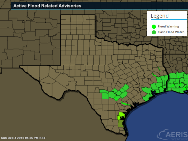
Flooding Concerns Continue
...FLASH FLOOD WATCH IN EFFECT THROUGH MONDAY AFTERNOON...

.RAINFALL RATES AND INTENSITY WILL INCREASE LATER TONIGHT AND ON
MONDAY AS A SURFACE LOW...ALONG WITH A VIGOROUS UPPER LEVEL
DISTURBANCE...WILL MOVE ACROSS THE REGION. ANTECEDENT WET GROUND
CONDITIONS ARE CURRENTLY OVER A MAJORITY OF THE AREA FROM THE
RECENT RAINFALL. ADDITIONAL AREAWIDE RAINFALL TOTALS OF 1 TO 3
INCHES...WITH LOCALLY HIGHER AMOUNTS...IS STILL POSSIBLE IN THE
WATCH AREA THROUGH MONDAY. THESE RAINFALL AMOUNTS WILL HAVE THE
POTENTIAL TO CAUSE FLOODING. THE RAIN WILL END FROM WEST TO EAST
LATE MONDAY INTO MONDAY EVENING...ENDING THE FLASH FLOOD THREAT.
__________________________________________________________________
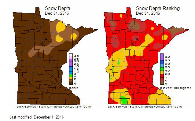
MN Snow Depth & Ranking
Here's a look at the snow depth across the state as of Thursday, December 1st. Note that much of the heavy snow that fell across western and northern MN a couple of weeks ago has since melted due to the ongoing mild weather through the end of November.
Each Thursday during the cold season, the State Climatology Office produces maps depicting the snow depth across Minnesota. Additionally, maps are created that depict snow depth ranking for the date. The data are provided by volunteers working with DNR Forestry, the National Weather Service, the University of Minnesota, Soil and Water Conservation Districts and CoCoRaHS.
 _____________________________________________________________________________
Here's a look at the snow depth across the state as of Thursday, December 1st. Note that much of the heavy snow that fell across western and northern MN a couple of weeks ago has since melted due to the ongoing mild weather through the end of November.
Each Thursday during the cold season, the State Climatology Office produces maps depicting the snow depth across Minnesota. Additionally, maps are created that depict snow depth ranking for the date. The data are provided by volunteers working with DNR Forestry, the National Weather Service, the University of Minnesota, Soil and Water Conservation Districts and CoCoRaHS.
Here's the weather outlook from Monday to Monday of next weekend. Note that we seem to have a few shots of light precipitation across the region with perhaps a better chance of snow next weekend. The big story will be the MUCH colder weather funneling into the region by the 2nd half of the week. This will be some of the coldest air of the season with highs dipping to well below normal temps for a several day period.


5 Day Precipitation Outlook
The 5 day precipitation outlook through the end of next week suggests fairly light precipitation amounts across the Upper Midwest. The heaviest moisture looks to be found along the international border and across the Middle Mississippi Valley into the Ohio Valley and parts of the Great Lakes Region.
______________________________________________________________________________
I feel like Mother Nature is a little groggy this year. She's certainly had tough time getting winter started. Sure, we've had a few bouts of snow here and there, but nothing has been sticking because it's been so warm!
The Twin Cities was officially 7 inches below normal snowfall for the month of November only tallying up 2.3 inches. We had nearly all of that with our weak storm system that moved through late Saturday night/early Sunday morning, but again most of it melted due to above freezing temps.
Temps warm to near 40 degrees across the southern half of the state on Monday ahead of our biggest cool down of the season that will settle in later this week. Single digit wind chills will have most of us reaching for extra layers Wednesday through Friday.
We sneak up close to average this weekend as another light snow chance moves through, but the long range temperature forecast keeps us below average through the middle part of the month.
No major snow storms brewing yet, but temps 'should' be cold enough to favor a white Xmas.
___________________________________________________
Extended Weather Outlook
SUNDAY NIGHT: Mostly cloudy. Patchy freezing fog. Winds: SSW 5. Low: 28
MONDAY: Mild. Light mix later. Winds: SSW 10-15. High: 41.
MONDAY NIGHT: Mostly cloudy, slight chance of light snow. Winds: W 10. Low: 25.
TUESDAY: AM flakes, turning breezy and cooler. Winds: W 10-20. High: 29
WEDNESDAY: Brisk wind, A few flurries. Winds: WNW 10-15. Wake-up: 14. High: 19
THURSDAY: Colder. Scattered light snow showers. Winds: NW 10-15. Wake-up: 13. High: 20.
FRIDAY: Less wind. More sun, still chilly. Winds: ESE 5-10. Wake-up:10. High: 19.
SATURDAY: Increasing clouds, chance of snow. Winds: SE 5. Wake-up: 11. High: 22.
SUNDAY: Lingering light snow, more PM sun. Winds: WNW 5. Wake-up: 16. High: 20.
_______________________________
_______________________________
This Day in Weather History
December 5th:
2001: An unseasonably warm December day occurs, with a high of 63 degrees at the Twin Cities. Summer-like thunderstorms developed and dropped quarter-sized hail at the Eyota Post Office in Olmsted County.December 5th:
1979: Mild air moves in to Minnesota, with highs of 52 at St. Cloud and 54 at Browns Valley.
1928: Canby receives three inches of snow or greater for the third consecutive day.
________________________________
Average High/Low for Minneapolis
December 5th
Average High: 30F (Record: 63F set in 2001)
Average Low: 16F (Record: -14F set in 1873)
Average Low: 16F (Record: -14F set in 1873)
Record Snowfall: 7.0" set in 1909
_________________________________
_________________________________
Sunrise/Sunset Times for Minneapolis
December 5th
December 5th
Sunrise: 7:35am
Sunset: 4:32pm
Sunset: 4:32pm
*Daylight Lost Since Yesterday: ~1mins & 14sec
*Daylight Lost Since Summer Solstice: ~6hours and 38mins
______________________________________________________________________
*Daylight Lost Since Summer Solstice: ~6hours and 38mins
______________________________________________________________________
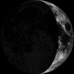
Moon Phase for December 4th at Midnight
2.1 Days Before First Quarter
2.1 Days Before First Quarter
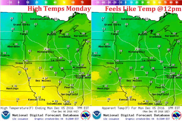
Weather Outlook Monday
High temps on Monday will be quite warm ahead of a cold front that will bring us our coldest air of the season later this week. Note that some spots in southern MN will warm to near 40F!
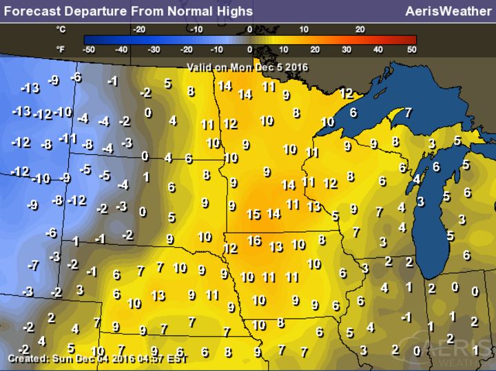
High Temperatures From Average Monday
Here's a look at high temperatures from average on Monday, which shows many spots across the state seeing readings nearly 10F to 15F above average! Enjoy the warmth while you can, temperatures by the end of the week will be nearly 10F to 15F below average with wind chills in the single digits!
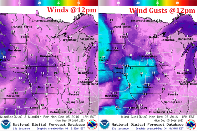
Weather Outlook Monday
Winds will be a little stronger on Monday as our next system gets closer. Note that sustained winds will be nearly 10mph to 15mph with wind gusts across southern MN reaching 20mph+.
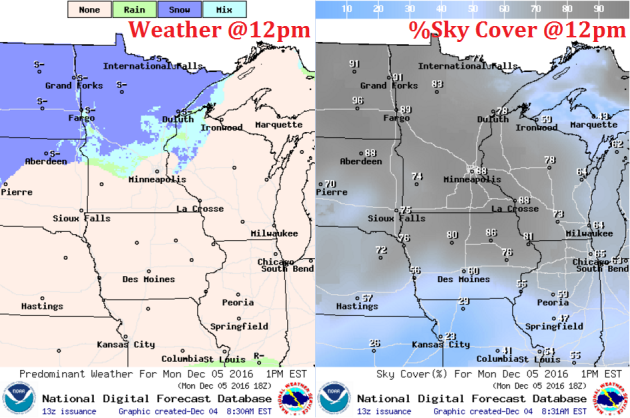
Weather Outlook Monday
Another system moves through the region on Monday with a light rain/snow mix across central MN. The best chance of snow will be found across the northern half of the state with some minor accumulations possible there through Tuesday.
___________________________________________________________
Simulated Radar
Take a look at the simulated radar from AM Monday to AM Wednesday. Note the rain/snow mix potential on Monday as our next storm system moves into the region. Lingering snow chances across the northern part of the state will allow for some minor snow accumulations there. The bigger story will be the more significant cool down that this system will be responsible for. Temps will be 10F to near 15F below average by the end of the week.
Simulated Radar
The simulated radar from PM Sunday to Wednesday shows next chance of moisture rolling through Monday and Tuesday. It appears that we may start off as a little rain, but the colder air will pour in behind an Arctic front, which will turn any leftover moisture into snow through the rest of the week, especially across northern MN.
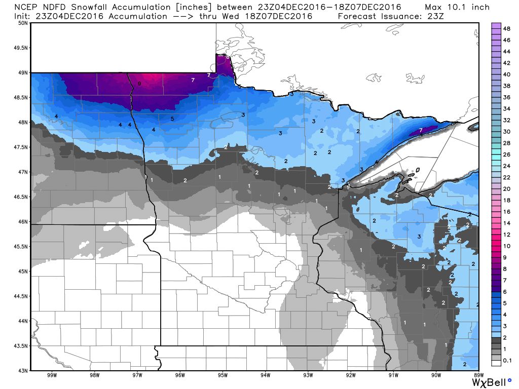
Snowfall Potential
Here's a look a the snowfall potential through midday Wednesday, which shows another chance of light snow across northern Minnesota as our cold air starts to move into the region. Some spots in extreme northwestern MN could see nearly 6" by midweek.
 _______________________________________
Extended Weather Outlook
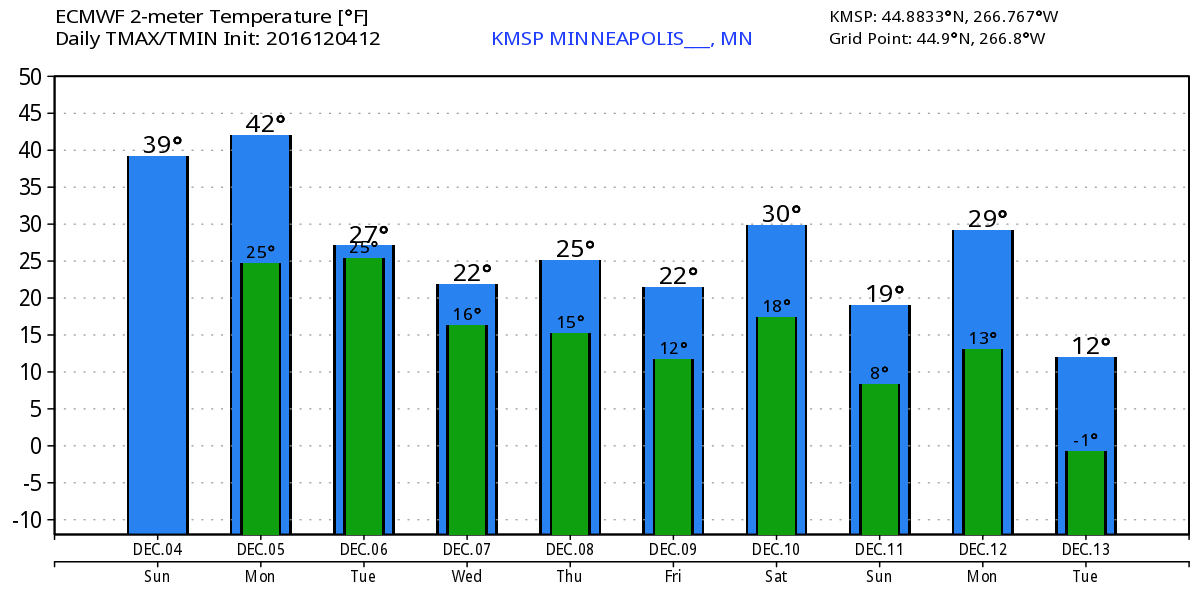
The temperature outlook for Minneapolis into next weekend shows some big changes coming through the weather pipeline. Note the warming taking place through Monday, but a fairly significant whack of colder air settles in by the middle and end of next week with highs dipping into the 10s and 20s. Overnight lows will also dip into the single digits and 10s across much of the state.
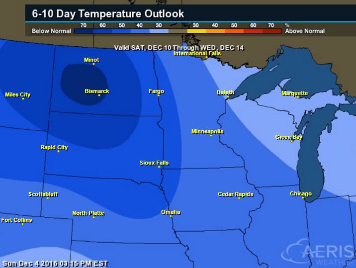
6 to 10 Day Temperature Outlook
According to NOAA's CPC, the 6 to 10 day temperature outlook suggests colder than average temperatures settling into the region as we continue through the first half of December. Note that this will likely be some of the coldest air of the season for many spots across the Upper Midwest.
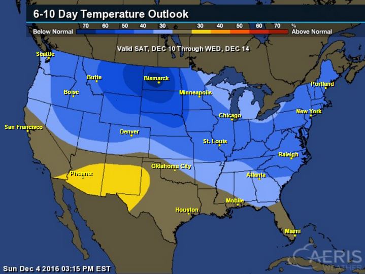
Here's the national temperature outlook from December 10th - December 14th, which shows a big chunk for colder than average temperatures settling into much of the nation. This will be one of the first big colder outbreaks of the season.... Are you ready!
 __________________________________________
National Weather Outlook
The weather looks to be fairly active across the southeastern US as we head through the early week time frame. A large blob of Gulf of Mexico moisture will continue moving northeast with heavy rainfall and scattered storms, some possibly strong to severe through Tuesday. Meanwhile, heavier moisture in the form of coastal rain and high elevation snow will move into the Pacific Northwest.
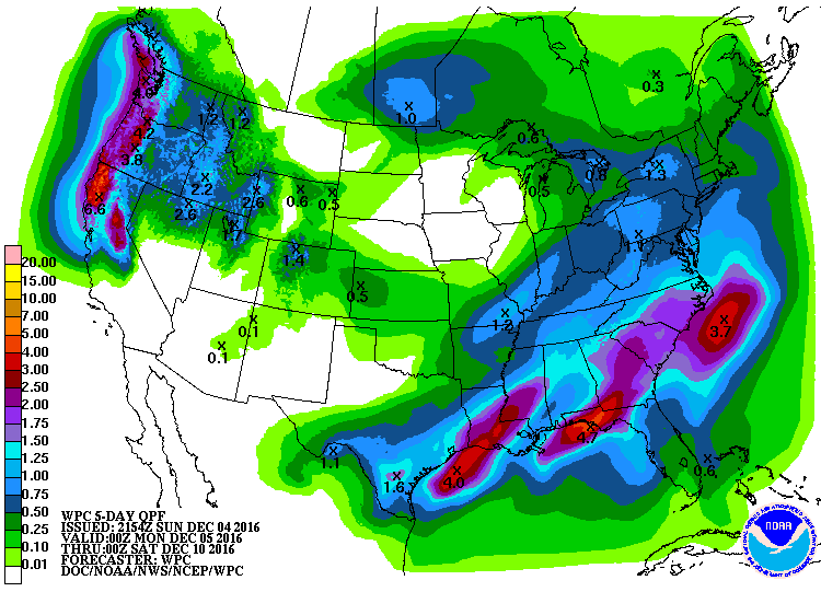
5 Day Precipitation Outlook
According to NOAA's WPC, the 5 day precipitation outlook suggests significant moisture across the southeastern US through the end of next week. Widespread 2" to 4"can't be ruled out. This may lead to areas of flooding near the Lower Mississippi Valley, but this additional heavy rain will be very beneficial for the drought conditions in the Southeast.
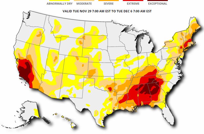
US Drought Monitor
Here's the updated drought monitor from Thursday, December 1st, which shows widespread extreme to exceptional drought conditions across much of the Southeast. While heavy rainfall last week helped some, we need more, so the upcoming heavy rainfall through the first full week of December (next week) is good news!
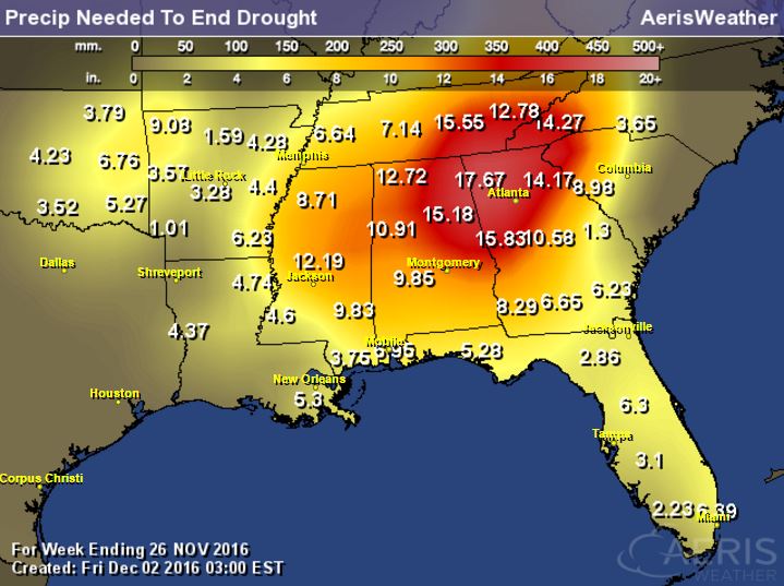
Rainfall Needed to End Drought
The product below suggests how much rainfall is needed to end the drought. Note that many spots need nearly a foot of rain or more to end the drought. These are the areas that are in an extreme to exceptional drought!
National Snowfall Outlook
Here's the potential snowfall through the the middle part of December, which shows the POTENTIAL of heavier snow developing across the northern tier of the nation over the next couple of weeks. This would be a big change from what we had during much of November as it was a generally quiet and warm month across the nation. 
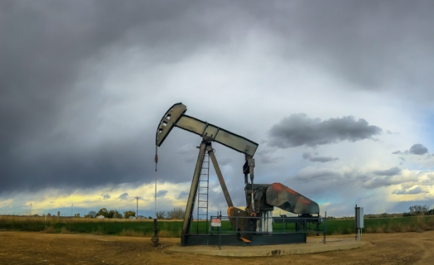
_____________________________________________________________________________"U.S. Oil Exports Skyrocket Despite Climate Pacts"
"Seven years ago, the U.S. exported its crude oil to just one country — Canada. This year, 22 countries received American crude oil, marking a more than 1,000 percent increase in U.S. oil exports since 2009, according to U.S. Department of Energy data released this week. Since Congress lifted restrictions on American oil exports a year ago, more and more U.S. crude oil has been streaming onto the global oil market to supply the world’s growing demand. It’s happening even as the U.S. and Canada have agreed to cut emissions from oil and gas operations and countries agree to cut their greenhouse gas pollution under the Paris Climate Agreement. The international pact aims to prevent global warming from exceeding 2°C (3.6°F)."
See more from Climate Central HERE:
(An oil well in Colorado. Credit: C.L. Baker/flickr)
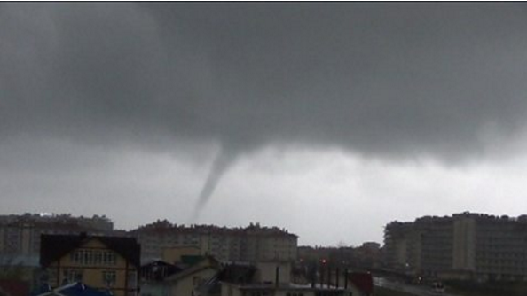
"A small tornado descended on Russia's Olympic city Sochi as stormy weather battered the coastline."
See more from BBC HERE:
"NASA astronauts on board the International Space Station on Friday reaped the first harvest of red romaine lettuce leaves grown on the orbiting space lab last month. These vegetables were grown using the "Veggie" plant growth system on the ISS, and were harvested as part of a technique the space agency calls "cut-and-come-again." "Cut-and-come-again is a repetitive harvest technique in which a selection of leaves can be harvested for a bit of fresh lettuce and possibly science samples," NASA explained in a statement. "The remaining leaves and the core of the plant are left intact and will continue to grow and produce more leaves for subsequent harvests approximately every 10 days." The goal of this technique is to improve the yield of crops being grown in the micro-gravity environment of space, where plant roots grow every which way, making it excruciatingly difficult for them to absorb the nutrients and water they need to survive."
See more from IBTimes HERE:
(An artist's concept showing plants being grown in space. Photo: NASA)


No comments:
Post a Comment