Big Snow on the Big Island
Hawaii's highest peak could get up to another foot of snow Sunday, on top of the 2 feet that have fallen since Thursday, the National Weather Service says. A winter storm warning is in effect for the summits of Mauna Loa and Mauna Kea through Saturday evening. “Then we’re expecting another round on Sunday and Sunday night,” said Matthew Foster, a staff meteorologist with the National Weather Service in Honolulu. Snow on the peaks is not uncommon in the colder months of the year, though deep snow is rare. “We’ll probably see three to five snow events a year during the cold season. Some years we might not get any, some years we might get more,” said Foster. The only other area of Hawaii that gets snow with any regularity is the Haleakalā volcano on Maui, which at about 10,000 feet gets snow once every five years or so, he said."
See more from USA Today HERE:
"In this image made from webcam video provided by Canada-France-Hawaii Telescope, the CFHT telescope on the summit of Mauna Kea on Hawaii's Big Island is covered in snow on Thursday, Dec. 1, 2016. The National Weather Service in Honolulu has issued a winter storm warning for the summits of Hawaii's Big Island as wind and snow engulf the high peaks. (Canada-France-Hawaii Telescope via AP)"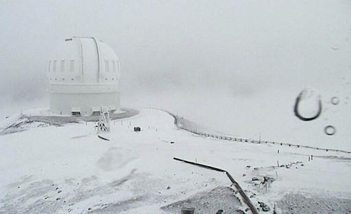
Pacific Moisture Moves into the Pacific Northwest
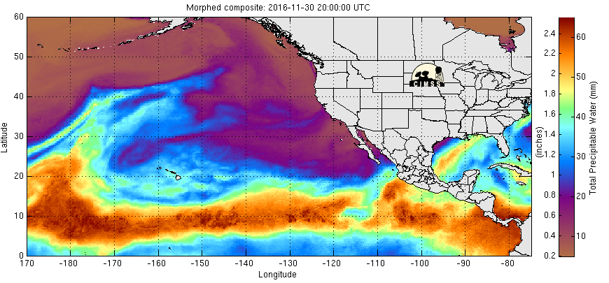
Here's the Eastern Pacific precipitable water loop that shows heavier moisture from the Pacific moving into the West Coast in a few different waves. These rounds of heavier moisture have been responsible for heavier coastal rains and high elevation snow. Another one of these storms is moving through the Pacific Northwest now with heavier snow possible through early next week.
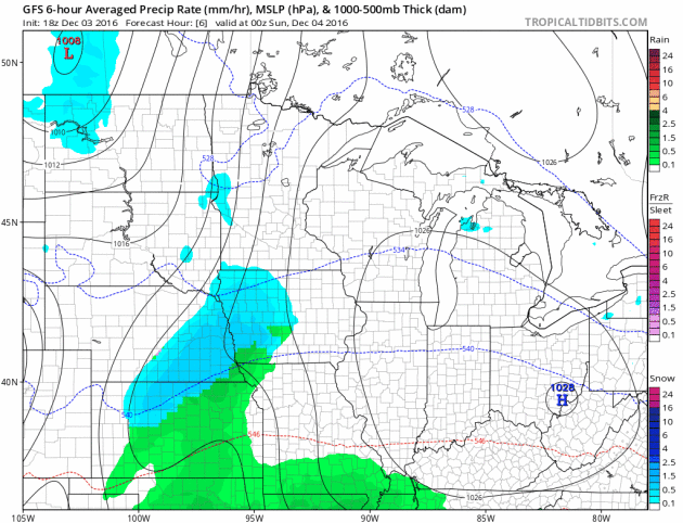
Another Surge of Heavier Pacific Moisture
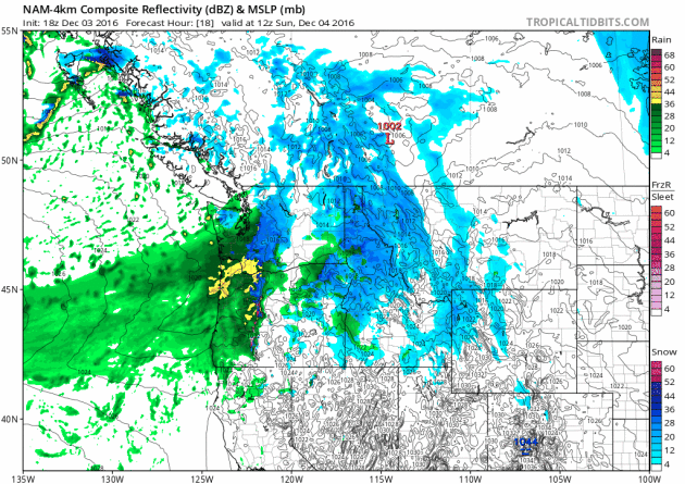
Here's a look at the next storm system moving through the region through the early part of next week. Note that areas along the coast and in the lower elevations will likely see rain, while those in the higher elevations will see snow. Some spots could see 1ft to 2ft by early next week.
 Winter Weather Headlines
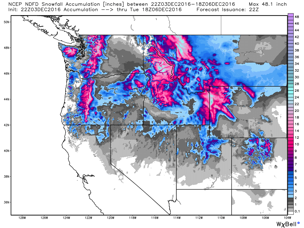
Snow in the Northwest
Here's the snowfall potential through midday Tuesday, which shows fairly significant tallies across the Cascade range and across much of the northern Rockies. Some spots could see up to 1ft. to 2ft. through early next week.
According to NOAA's NOHRSC, 25.8% of the nation was covered up in snow as of December 3rd. Last year at this time, 33.4% of the nation was covered up by snow!
 __________________________________________________________________________________
 Heavy Southern Rain
__________________________________________________________________
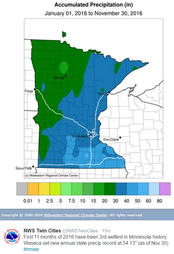
3rd Wettest January - November on Record for the Twin Cities
Year to date precipitation through December 1st saw 38.18" of precipitation in the Twin Cities, which is 8.69". According to the Twin Cities NWS, the first 11 months of 2016 have been the 3rd wettest in history! Interestingly, Waseca set a new annual state precip record with 54.13" and the year isn't over yet!
 Somewhat Active Pattern With Colder Temps Ahead.
Hawaii's highest peak could get up to another foot of snow Sunday, on top of the 2 feet that have fallen since Thursday, the National Weather Service says. A winter storm warning is in effect for the summits of Mauna Loa and Mauna Kea through Saturday evening. “Then we’re expecting another round on Sunday and Sunday night,” said Matthew Foster, a staff meteorologist with the National Weather Service in Honolulu. Snow on the peaks is not uncommon in the colder months of the year, though deep snow is rare. “We’ll probably see three to five snow events a year during the cold season. Some years we might not get any, some years we might get more,” said Foster. The only other area of Hawaii that gets snow with any regularity is the Haleakalā volcano on Maui, which at about 10,000 feet gets snow once every five years or so, he said."
See more from USA Today HERE:
"In this image made from webcam video provided by Canada-France-Hawaii Telescope, the CFHT telescope on the summit of Mauna Kea on Hawaii's Big Island is covered in snow on Thursday, Dec. 1, 2016. The National Weather Service in Honolulu has issued a winter storm warning for the summits of Hawaii's Big Island as wind and snow engulf the high peaks. (Canada-France-Hawaii Telescope via AP)"
Pacific Moisture Moves into the Pacific Northwest
Here's the Eastern Pacific precipitable water loop that shows heavier moisture from the Pacific moving into the West Coast in a few different waves. These rounds of heavier moisture have been responsible for heavier coastal rains and high elevation snow. Another one of these storms is moving through the Pacific Northwest now with heavier snow possible through early next week.
Another Surge of Heavier Pacific Moisture
Here's a look at the next storm system moving through the region through the early part of next week. Note that areas along the coast and in the lower elevations will likely see rain, while those in the higher elevations will see snow. Some spots could see 1ft to 2ft by early next week.
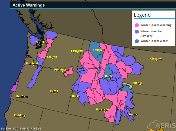
...WINTER STORM WARNING IN EFFECT THRU 11 AM MST MONDAY...

THE NATIONAL WEATHER SERVICE IN MISSOULA HAS ISSUED A WINTER
STORM WARNING FOR HEAVY SNOW AND BLOWING SNOW...WHICH IS IN
EFFECT FROM MIDNIGHT TONIGHT TO 11 AM MST MONDAY. THE WINTER STORM
WATCH IS NO LONGER IN EFFECT.

* IMPACTS/TIMING: SNOW WILL CONTINUE FOR TONIGHT AND SNOW
  INTENSITIES WILL INCREASE DURING THE DAY SUNDAY. THE COMBINATION
  OF ACCUMULATING SNOW AND WIND, VISIBILITY COULD BE GREATLY
  REDUCED, ESPECIALLY OVER MARIAS PASS. A PERIOD OF MODERATE TO
  HEAVY SNOW AND GUSTY WINDS IS LIKELY SUNDAY AFTERNOON AND EVENING
  WITH THE COLD FRONT. ALL OF THESE IMPACTS WILL CREATE HAZARDOUS
  TRAVEL CONDITIONS SUNDAY THROUGH THE FIRST PART OF MONDAY.

* SNOW ACCUMULATIONS SUNDAY THROUGH MONDAY: 10 TO 14 INCHES WITH
  ISOLATED HIGHER AMOUNTS IN THE MOUNTAINS AND MARIAS PASS.

* WINDS: GUSTY WEST NORTHWEST WINDS OF 30 TO 40 MILE PER HOUR
  POSSIBLE FOR MARIAS PASS.
Snow in the Northwest
Here's the snowfall potential through midday Tuesday, which shows fairly significant tallies across the Cascade range and across much of the northern Rockies. Some spots could see up to 1ft. to 2ft. through early next week.
National Snow Cover
Upcoming Heavy Rain in the South
Take a look at the heavy potential across the southern US through the end of the weekend! Widespread heavy rainfall could lead to areas of flooding over the next few days, especially over eastern Texas and the Lower Mississippi Valley. Not only will heavy rain be possible, but a few strong to severe storms may be possible into early next week as well.
Here's a look at the heavy rain potential through PM Sunday. Note that some spots in the eastern part of Texas and into the Lower Mississippi Valley could see up to 3" to 6"+ rainfall.
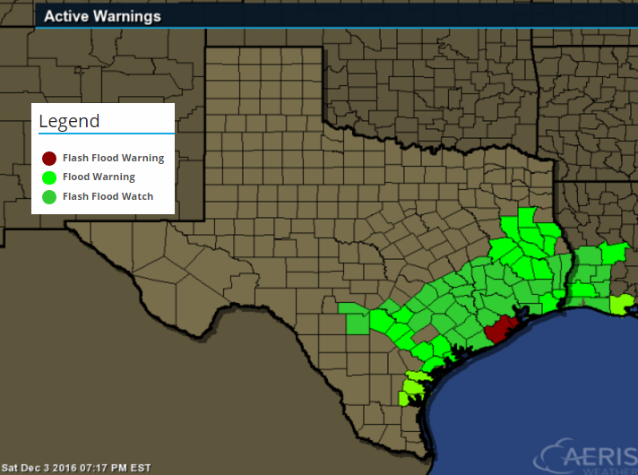
Flooding Concerns in Texas
...FLASH FLOOD WATCH REMAINS IN EFFECT THROUGH SUNDAY EVENING...

THE FLASH FLOOD WATCH CONTINUES FOR

* PORTIONS OF SOUTHEAST TEXAS...INCLUDING THE FOLLOWING
  COUNTIES...JACKSON...AUSTIN...BRAZORIA...BRAZOS...BURLESON...
  CHAMBERS...COLORADO...FORT BEND...GALVESTON...GRIMES...
  HARRIS...HOUSTON...LIBERTY...MADISON...MATAGORDA...
  MONTGOMERY...POLK...SAN JACINTO...TRINITY...WALKER...WALLER...
  WASHINGTON AND WHARTON.

* THROUGH SUNDAY EVENING

* A SERIES OF UPPER LEVEL DISTURBANCES WILL PUSH THROUGH THE AREA
  TRIGGERING PERIODS OF RAIN WITH EMBEDDED STORMS. AS GROUNDS
  BECOME MORE SATURATED...THE THREAT OF FLASH FLOODING WILL
  PROGRESSIVELY INCREASE WHERE TRAINING HEAVIER CELLS MOVE OVER
  THE SAME AREA. EXCESSIVE RAINFALL HAS OCCURRED ALONG THE COAST
  ON SATURDAY...AND THAT WILL BE THE HIGHEST RISK LOCATION THROUGH
  SUNDAY MORNING. AN ADDITIONAL 2 TO 4 INCHES...WITH LOCALLY
  HIGHER AMOUNTS IN EXCESS OF 8 INCHES ARE POSSIBLE THROUGH
  MONDAY. WHERE GROUND IS ALREADY SATURATED IT IS MOST IMPORTANT
  TO FOCUS ON SHORT TERM RAINFALL RATES RATHER THAN TOTALS
  THEMSELVES. EVEN SHORT BURSTS OF HEAVY RAINFALL WILL QUICKLY
  CAUSE FLASH FLOODING AT THOSE LOCATIONS. TO FURTHER COMPLICATE
  THINGS...ELEVATED WATER LEVELS IN THE BAYS AND NEARSHORE GULF WILL
  DELAY DRAINAGE OF WATER.

* STREET FLOODING AND FLOODING OF LOW LYING AREAS WILL BE THE MOST
  LIKELY IMPACT TONIGHT. AS OF SATURDAY EVENING...AREA
  RIVERS...STREAMS AND BAYOUS WERE WITHIN BANKS. WE WILL CONTINUE
  TO MONITOR TRENDS.
__________________________________________________________________
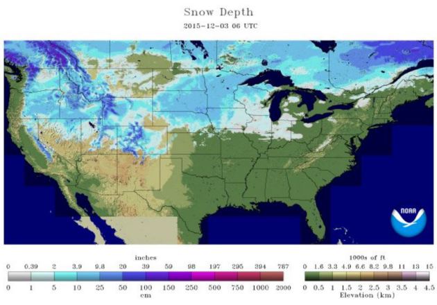
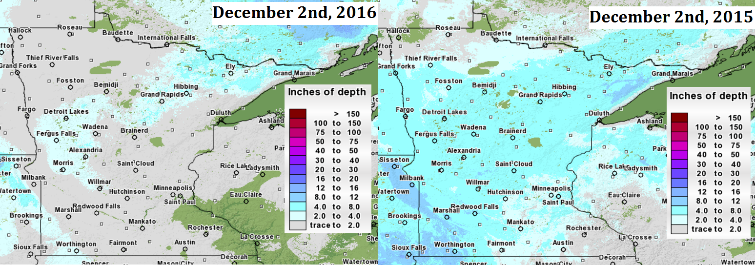
Snow Depth Comparison 2016 vs 2015
Here's a look at the snow depth comparison from now to this time last year. Note that there is only a little snow left across parts of western and northern MN from the storm system a couple of weeks ago. Last year at this time, much of the state had a least a little bit of snow. The Twin Cites officially had 3" of snow on the ground as of December 2nd, 2015.
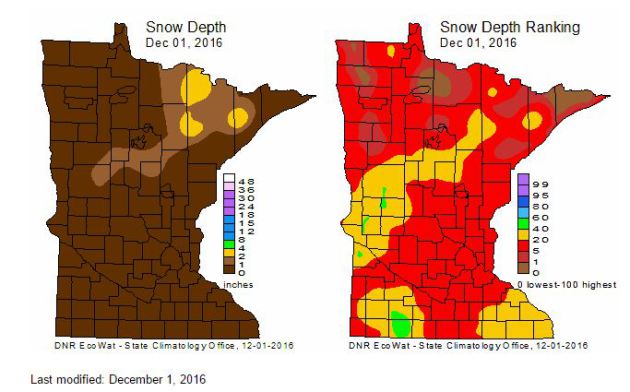
MN Snow Depth & Ranking
Here's a look at the snow depth across the state as of Thursday, December 1st. Note that much of the heavy snow that fell across western and northern MN a couple of weeks ago has since melted due to the ongoing mild weather through the end of November.
Each Thursday during the cold season, the State Climatology Office produces maps depicting the snow depth across Minnesota. Additionally, maps are created that depict snow depth ranking for the date. The data are provided by volunteers working with DNR Forestry, the National Weather Service, the University of Minnesota, Soil and Water Conservation Districts and CoCoRaHS.
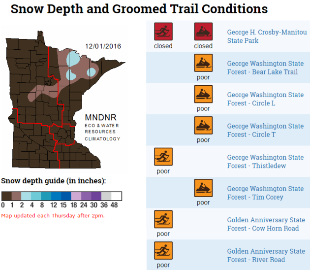
 Trail Conditions
Here's a look at the snow depth comparison from now to this time last year. Note that there is only a little snow left across parts of western and northern MN from the storm system a couple of weeks ago. Last year at this time, much of the state had a least a little bit of snow. The Twin Cites officially had 3" of snow on the ground as of December 2nd, 2015.
MN Snow Depth & Ranking
Here's a look at the snow depth across the state as of Thursday, December 1st. Note that much of the heavy snow that fell across western and northern MN a couple of weeks ago has since melted due to the ongoing mild weather through the end of November.
Each Thursday during the cold season, the State Climatology Office produces maps depicting the snow depth across Minnesota. Additionally, maps are created that depict snow depth ranking for the date. The data are provided by volunteers working with DNR Forestry, the National Weather Service, the University of Minnesota, Soil and Water Conservation Districts and CoCoRaHS.
Here's another nice product from the MN State Climatology office, which shows updated groomed trail conditions across the state. Note that with very little snow conditions across the state, many trails are either closed or in poor condition.
Year to date precipitation through December 1st saw 38.18" of precipitation in the Twin Cities, which is 8.69". According to the Twin Cities NWS, the first 11 months of 2016 have been the 3rd wettest in history! Interestingly, Waseca set a new annual state precip record with 54.13" and the year isn't over yet!
_____________________________________________________________________________
Here's the weather outlook from Saturday to Saturday of next weekend. Note that we seem to have a few shots of light precipitation across the region with perhaps a better chance of snow next weekend. The big story will be the MUCH colder weather funneling into the region by the 2nd half of the week. This will be some of the coldest air of the season with highs dipping to well below normal temps for a several day period.
5 Day Precipitation Outlook
The 5 day precipitation outlook through the end of next week suggests fairly light precipitation amounts across the Upper Midwest. The heaviest moisture looks to be found along the international border and across the Middle Mississippi Valley into the Ohio Valley and parts of the Great Lakes Region.
______________________________________________________________________________
It's been a strange year. Globally, we are well on our way to having the warmest year on record, which will beat the previous record set last year.
Regionally, the desert SouthEAST has been dealing with extreme and exceptional drought conditions, which was recently marked by the deadly fires near Gatlinburg, TN. Thank goodness more heavy rain is on the way this week as some of those areas still need 12 to 18 inches of rain to end the drought there.
Locally, the Twin Cities has seen its 3rd wettest 11 month period on record, running nearly 8.5 inches above average in the precipitation category since January 1st. Get this, as of November 30th, Waseca, MN has seen 54.13 inches of liquid, which is a new state annual precipitation record! Good grief.
Some wake up to a slushy coating Sunday as a quick moving clipper slides east. Temps warm to near 40 degrees on Monday with a few light rain showers late. Cold air breaks loose later this week with single digit wind chills for most.
Weather maps finally look like DecemBRRR!
___________________________________________________
Extended Weather Outlook
SATURDAY NIGHT: Snow develops, 1" to 2" of slush possible by daybreak. Winds: SSE 5. Low: 31.
SUNDAY: Light rain/snow mix early. Winds: WSW 5. High: 37.
SUNDAY NIGHT: Mostly cloudy. Winds: WSW 5. Low: 28
MONDAY: Mild. Peeks of AM sun. Few PM showers. Winds: SSE 5-15. High: 42
TUESDAY: Breezy. A few wind-whipped flakes up north. Winds: W 10-20. Wake-up: 26. High: 30
WEDNESDAY: Brisk wind, scattered flurries. Winds: W 10-20. Wake-up: 13. High: 19
THURSDAY: Mostly cloudy and colder. Winds: NW 10-15. Wake-up: 11. High: 19.
FRIDAY: Brighter skies. Less wind, still cold. Winds: NW 5-10. Wake-up: 8. High: 17.
SATURDAY: Increasing clouds, chance of snow. Winds: E-15. Wake-up: 8. High: 20.
_______________________________
_______________________________
This Day in Weather History
December 4th
1886: Minneapolis hits a record-setting 15 degrees below zero..December 4th
________________________________
Average High/Low for Minneapolis
December 4th
Average High: 31F (Record: 56F set in 1941)
Average Low: 16F (Record: -15F set in 1886)
Average Low: 16F (Record: -15F set in 1886)
Record Snowfall: 4.2" set in 1947
_________________________________
_________________________________
Sunrise/Sunset Times for Minneapolis
December 4th
December 4th
Sunrise: 7:34am
Sunset: 4:32pm
Sunset: 4:32pm
*Daylight Lost Since Yesterday: ~1mins & 18sec
*Daylight Lost Since Summer Solstice: ~6hours and 37mins
______________________________________________________________________
*Daylight Lost Since Summer Solstice: ~6hours and 37mins
______________________________________________________________________
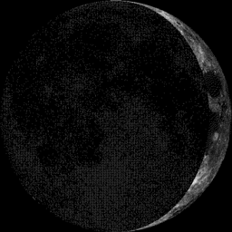
Moon Phase for December 3rd at Midnight
3.1 Days Before First Quarter
3.1 Days Before First Quarter
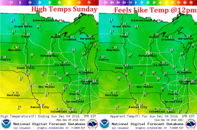
Weather Outlook Sunday
High temps on Sunday will still be running above average levels with many locations warming into the 30s. A few locations across the southern part of the state may be close to 40F.
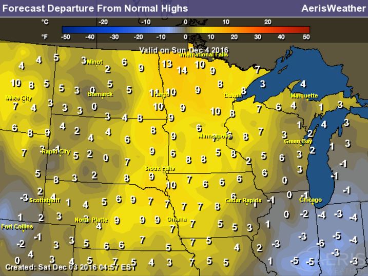
High Temperatures From Average Sunday
Here's a look at high temperatures from average on Sunday. Note that many locations will be nearly 5F to 10F above average. Temps on Monday will be nearly 10F to 15F above average before the cold air plunges into the region for the 2nd half of the week when we'll be nearly 10F to 15F below average.
Weather Outlook Sunday
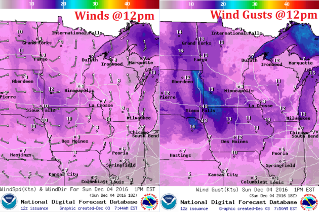
Winds will pick up just a little on Sunday as our weak system rolls through the region. Note that winds will be sustained up to near 10mph with gusts approaching 15mph to near 20mph across western MN.
Weather Outlook Sunday
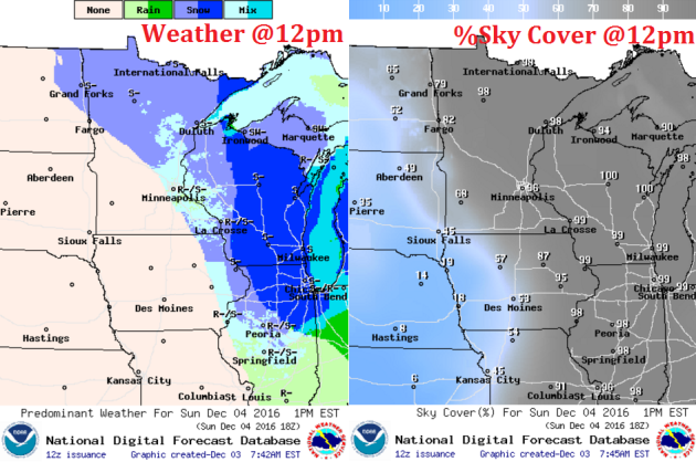
As our weak system continues to move through the region on Sunday, a light/rain snow mix will begin to taper through the day.
___________________________________________________________
Simulated Radar
The simulated radar from Saturday to Tuesday shows our quick moving system moving through PM Saturday to Sunday with minor slushy snow accumulations. The next chance of moisture doesn't roll through until late Monday/AM Tuesday. It appears that we may start off as a little rain, but the colder air will pour in behind an Arctic front, which will turn any leftover moisture into snow through the rest of the week.
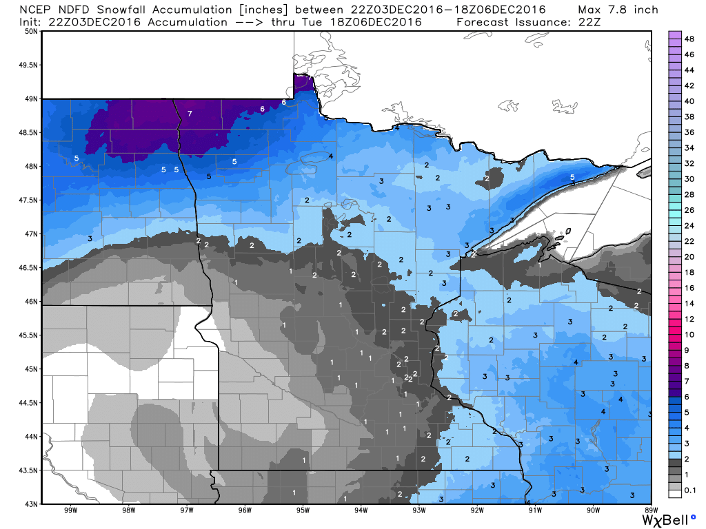
Snowfall Potential
Here's a look a the snowfall potential through midday Tuesday, which shows VERY light snow chances across the region. It appears that most of us won't see any accumulations, but there could be up to 1" across MN's north shore and into central Wisconsin.
 _______________________________________
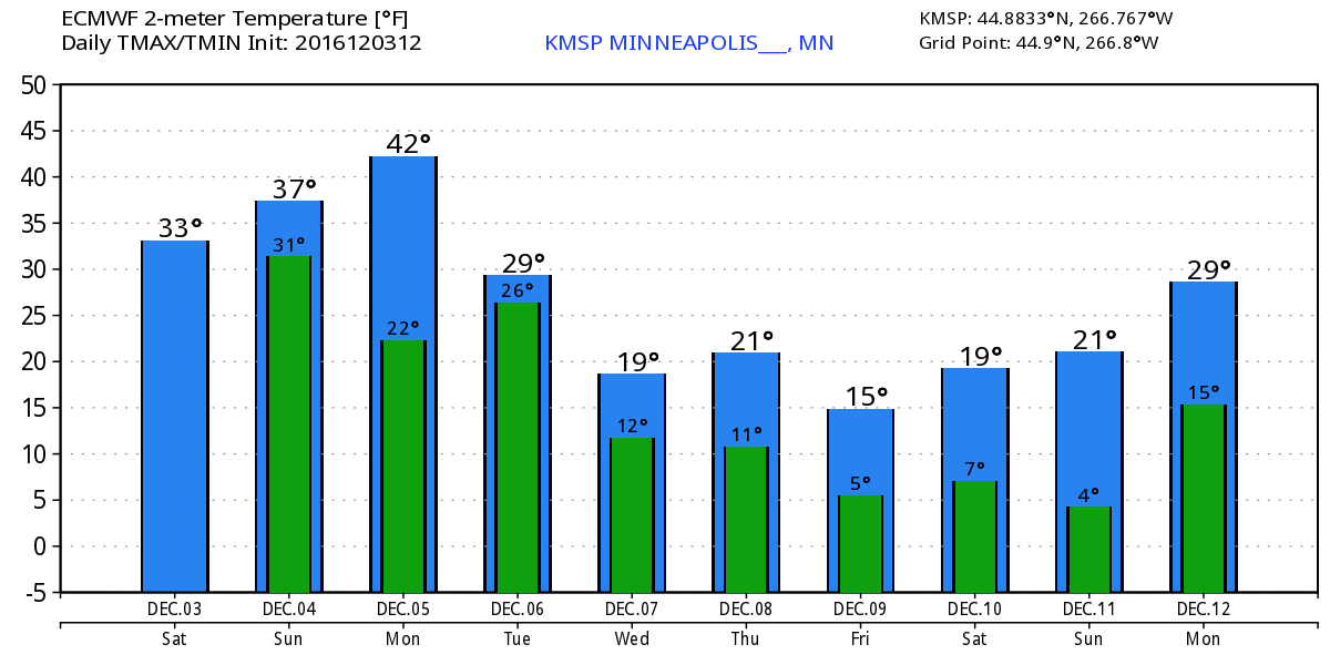
Extended Weather Outlook
The temperature outlook for Minneapolis into next weekend shows some big changes coming through the weather pipeline. Note the warming taking place through Monday, but a fairly significant whack of colder air settles in by the middle and end of next week with highs dipping into the 10s and 20s. Overnight lows will also dip into the single digits and 10s across much of the state.
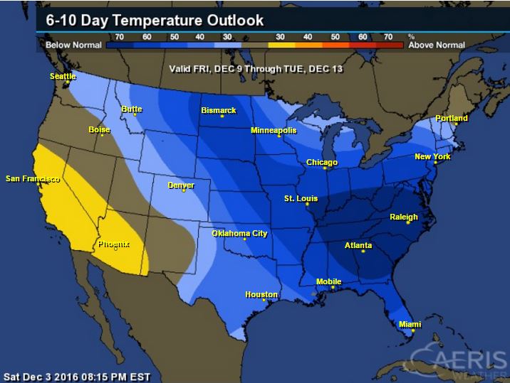
6 to 10 Day Temperature Outlook
According to NOAA's CPC, the 6 to 10 day temperature outlook suggests colder than average temperatures settling into the region as we continue through the first part of December. Note that this will likely be some of the coldest air of the season for many spots across the Upper Midwest.
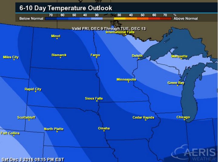
Here's the national temperature outlook from December 9th - December 13th, which shows a big chunk for colder than average temperatures settling into much of the nation. This will be one of the first big colder outbreaks of the season.... Are you ready!
 __________________________________________
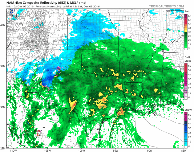
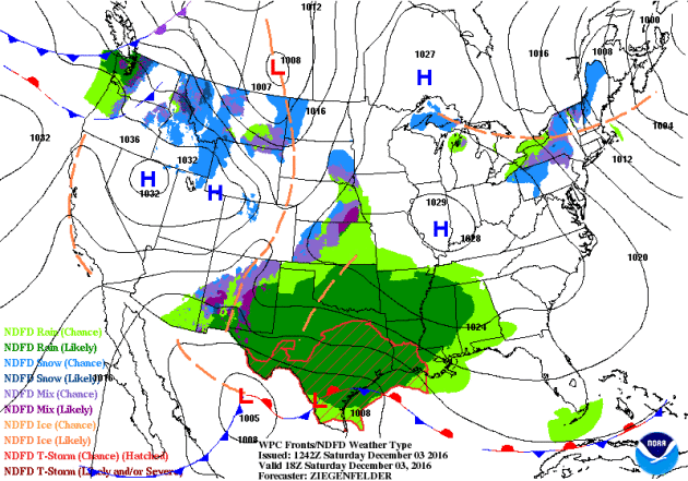
National Weather Outlook
The weather looks to be fairly active across the southern US as we head through the weekend. A large blob of Gulf of Mexico moisture will begin settling into the South-central US with areas of heavy rainfall and scattered storms, some possibly strong to severe into early next week. Meanwhile, heavier moisture in the form of coastal rain and high elevation snow will move into the Pacific Northwest.
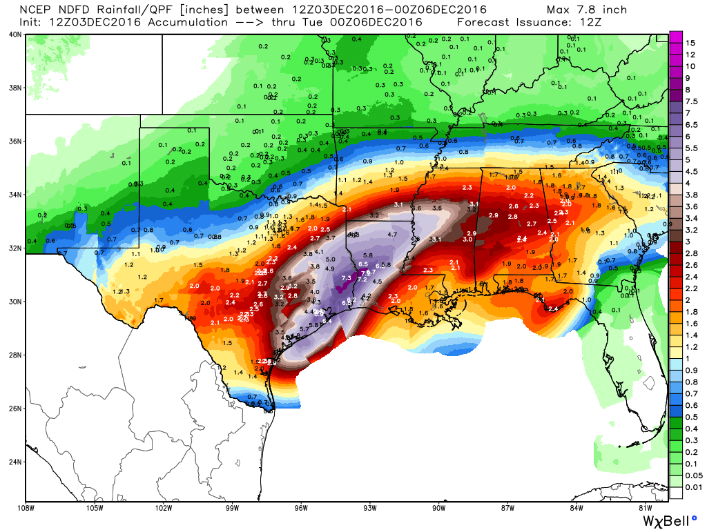
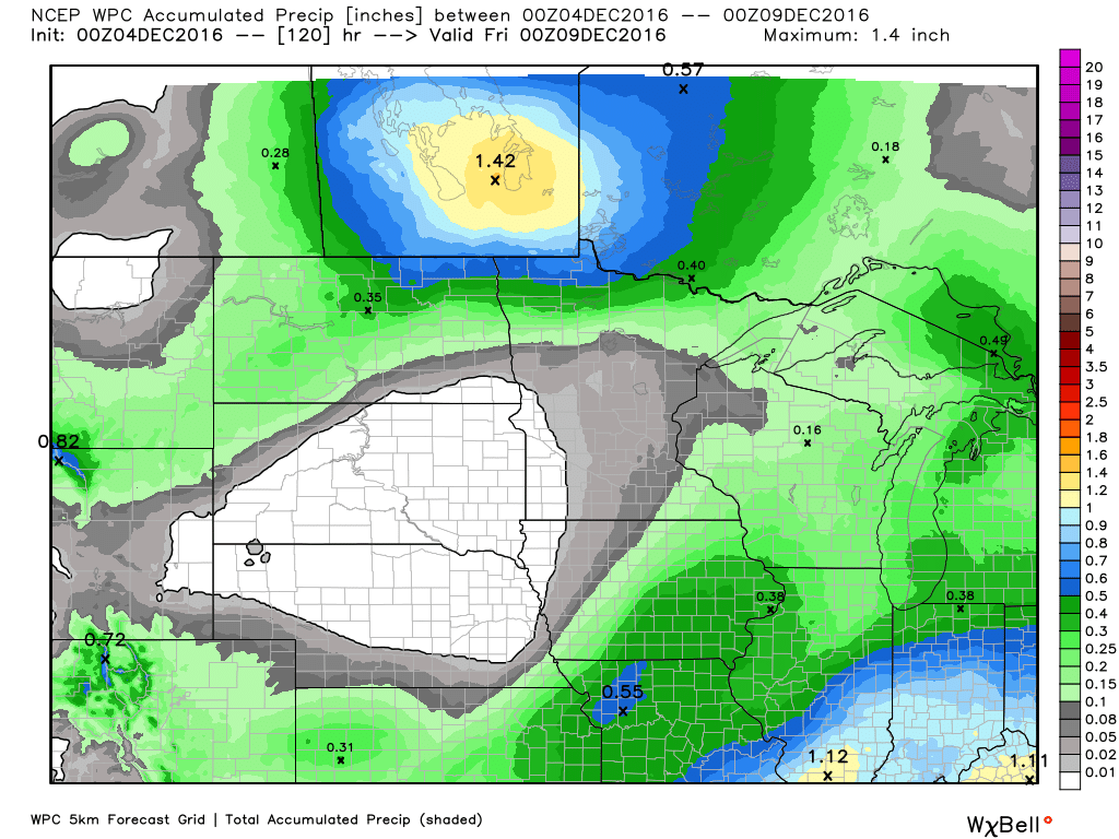
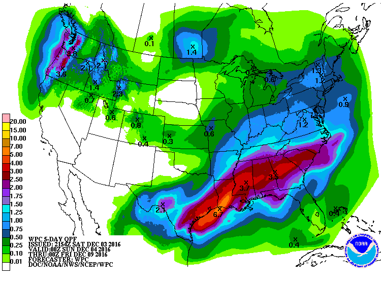
5 Day Precipitation Outlook
According to NOAA's WPC, the 5 day precipitation outlook suggests significant moisture across the southern US through the middle part of next week. Widespread 2" to 4" (isolated 3" to 6") can't be ruled out. This may lead to areas of flooding, but this additional heavy rain will be very beneficial for the drought conditions in the Southeast.
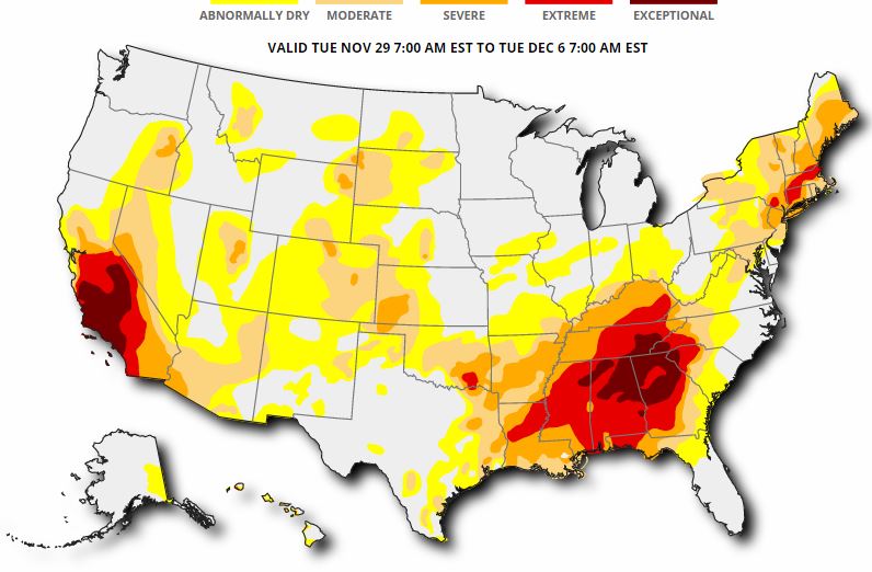
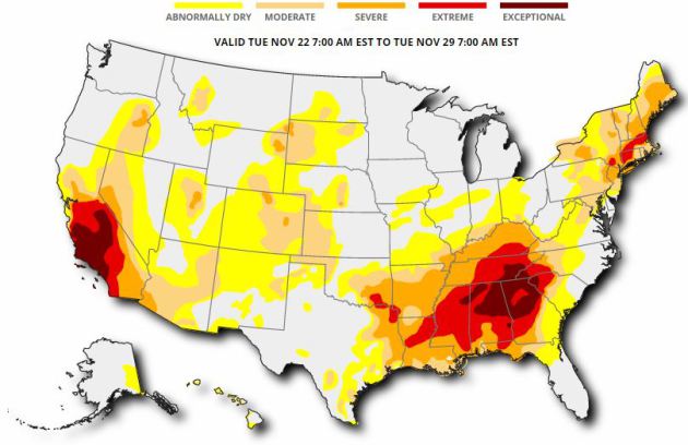
US Drought Monitor
Here's the updated drought monitor from Thursday, December 1st, which shows widespread extreme to exceptional drought conditions across much of the Southeast. While heavy rainfall last week helped some, we need more, so the upcoming heavy rainfall through the first full week of December (next week) is good news!
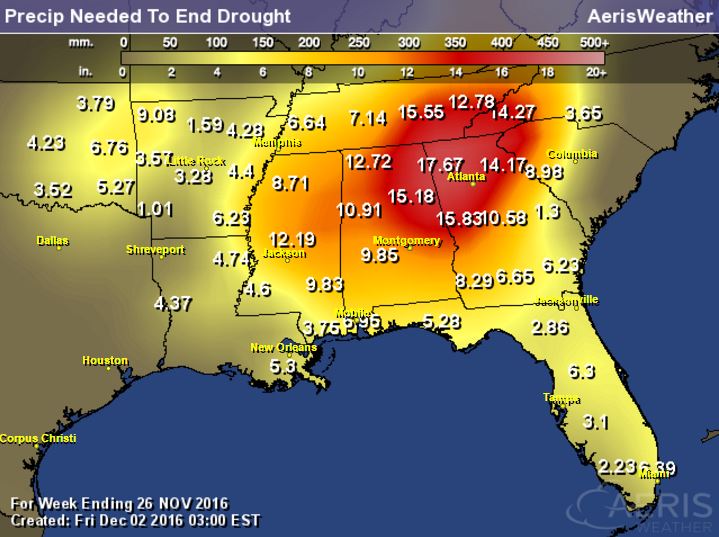
Rainfall Needed to End Drought
The product below suggests how much rainfall is needed to end the drought. Note that many spots need nearly a foot of rain or more to end the drought. These are the areas that are in an extreme to exceptional drought!
National Snowfall Outlook
Here's the potential snowfall through the the middle part of December, which shows the POTENTIAL of heavier snow developing across the northern tier of the nation over the next couple of weeks. This would be a big change from what we had during much of November as it was a generally quiet and warm month across the nation.
Drought Update
According to the US Drought Monitor, 55% of the nation of considered to be abnormally dry, while 17% of the country is in a severe drought, 8% is in an extreme drought and nearly 3% is in an exceptional drought. This is a little worse than it was a week ago. The good news is that we've recently gotten into a more active pattern, so hopefully we'll see some improvement in drought conditions across parts of the nation.
_________________________________________________________________________________
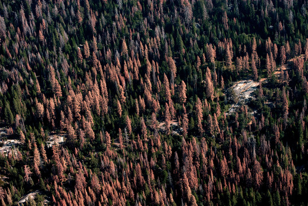
"An ‘Unprecedented’ 102 Million Trees Have Died In California’s Drought-Stricken Forests"
"In California’s drought-stricken forests, trees are dying at an “unprecedented” rate, according to officials. The U.S. Forest Service said last month that 102 million trees have died across the state since 2010, including 62 million dead trees in 2016 alone. And the die-off is showing no signs of slowing. “Millions of additional trees are weakened and expected to die in the coming months and years,” said the Forest Service. “The scale of die-off in California is unprecedented in our modern history,” Randy Moore, a forester with the agency, told the Los Angeles Times. Trees are dying “at a rate much quicker than we thought.”"
(US FOREST SERVICE In 2016 alone, 62 million trees died in California’s forests, said the U.S. Forest Service. This represents more than a 100 percent increase in dead trees across the state since 2015.)
__________________________________________________________________________
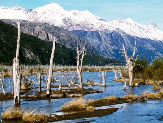
"Dozens of Earthquakes Rattle a Chilean Volcano, Raising Alerts"
"THE ONEMI (Oficina Nacional de Emergencias) and SERNGEOMIN (Chilean Geological Survey) in Chile raised the alert status for the area around Cerro Hudson in the southern Andes. Normally, raising the alert status like this is due to an acute change, when the behavior of the volcano shifts suddenly. However, this time, the elevation to Yellow alert status at Cerro Hudson is due to accumulated events over the past month. Dozens of small earthquakes have occurred since the start of November, none stronger than M3.2. But their location (in geographic space and depth) are similar to those before the last eruption of Hudson in 2011. The number of earthquakes hasn’t increased much above the baseline activity at an active volcano like Hudson, but energy released by the largest earthquakes has been increasing over the past few months. Combine that with the fact that the earthquakes have the character of those associated with magma movement, and the SERNAGEOMIN and ONEMI decided to treat Hudson with an abundance of caution, setting up a 3.5 kilometer exclusion zone around the volcano."
(Dead trees in the River Ibanez valley killed by ash from the Cerro Hudson eruption in 2011.JOHN WARBURTON-LEE/GETTY IMAGES)
_______________________________________________________________________
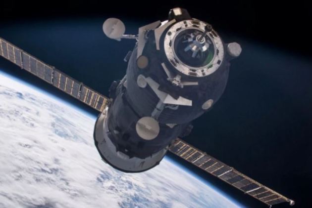
"Russian Cargo Spacecraft May Be Lost in Space"
"An uncrewed, robotic Progress spacecraft experienced problems en route to the International Space Station Russia's space agency, Roscosmos, launched a new cargo ship to the International Space Station today (Dec. 1), but the fate of the robotic supply ship is unclear after issues cropped up during its trip into space. The unmanned Progress 65 spacecraft blasted off atop a Russian Soyuz-U rocket at 9:51 a.m. EST (1451 GMT) from the Baikonur Cosmodrome in Kazakhstan on a mission to deliver more than 2.5 tons (2.3 metric tons) of food, equipment and other supplies to the space station. It was expected to arrive at the space station on Saturday (Dec. 3). [Watch: NASA Explains Status of Progress 65 Spacecraft] But while the initial moments of the flight went as planned, flight controllers at Russia's mission control center near Moscow detected "ratty telemetry" as the Soyuz booster's third stage was firing."
(After problems during launch a robotic Progress spacecraft, similar to this one photographed approaching the International Space Station in June, may be lost in space. Credit: NASA)
________________________________________________________________________________

No comments:
Post a Comment