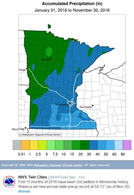
3rd Wettest January - November on Record for the Twin Cities
Year to date precipitation through December 1st saw 38.18" of precipitation in the Twin Cities, which is 8.69". According to the Twin Cities NWS, the first 11 months of 2016 have been the 3rd wettest in history! Interestingly, Waseca set a new annual state precip record with 54.13" and the year isn't over yet!
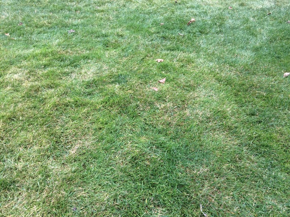
 Green Grass in December?
Welcome to meteorological winter... I know that calendar says December, but it sure doesn't look like it. For goodness Pete, my grass is green! I should stir things up and fire up the lawn mower... freak out the neighbors a little.
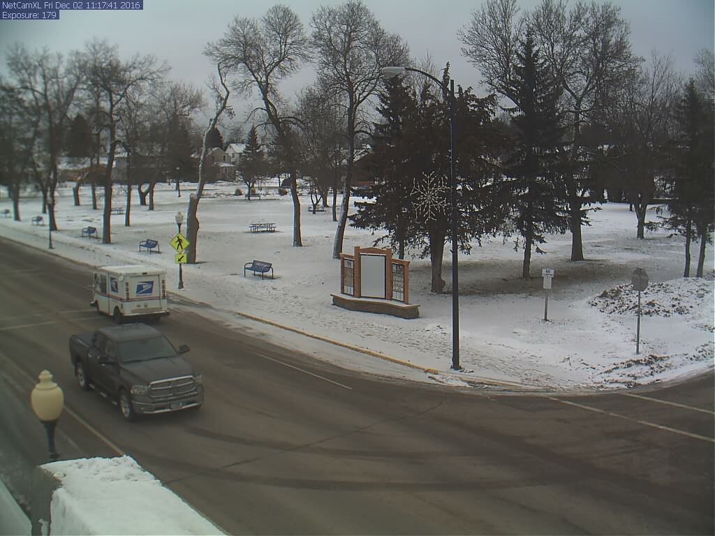
Ely MN
The picture below is from Ely, MN on Friday, which still shows a little snow on the ground from the big storm system that moved through a couple of weeks ago.
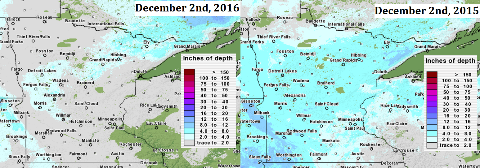
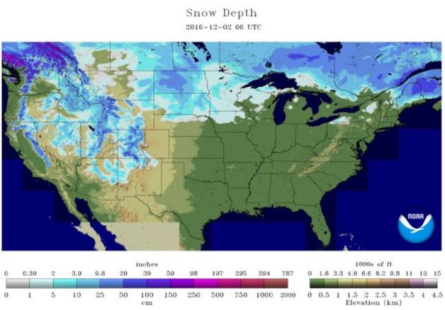
Snow Depth Comparison 2016 vs 2015
Here's a look at the snow depth comparison from now to this time last year. Note that there is only a little snow left across parts of western and northern MN from the storm system a couple of weeks ago. Last year at this time, much of the state had a least a little bit of snow. The Twin Cites officially had 3" of snow on the ground as of December 2nd, 2015.
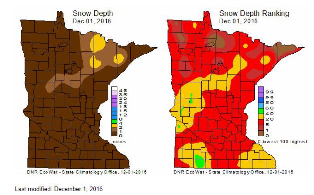
MN Snow Depth & Ranking
Here's a look at the snow depth across the state as of Thursday, December 1st. Note that much of the heavy snow that fell across western and northern MN a couple of weeks ago has since melted due to the ongoing mild weather through the end of November.
Each Thursday during the cold season, the State Climatology Office produces maps depicting the snow depth across Minnesota. Additionally, maps are created that depict snow depth ranking for the date. The data are provided by volunteers working with DNR Forestry, the National Weather Service, the University of Minnesota, Soil and Water Conservation Districts and CoCoRaHS.
According to NOAA's NOHRSC, 28.6% of the nation was covered up in snow as of December 2nd. Last year at this time, 34.7% of the nation was covered up by snow!
 _____________________________________________________________________________
Somewhat Active Pattern With Colder Temps Ahead.
Year to date precipitation through December 1st saw 38.18" of precipitation in the Twin Cities, which is 8.69". According to the Twin Cities NWS, the first 11 months of 2016 have been the 3rd wettest in history! Interestingly, Waseca set a new annual state precip record with 54.13" and the year isn't over yet!
Welcome to meteorological winter... I know that calendar says December, but it sure doesn't look like it. For goodness Pete, my grass is green! I should stir things up and fire up the lawn mower... freak out the neighbors a little.
Ely MN
The picture below is from Ely, MN on Friday, which still shows a little snow on the ground from the big storm system that moved through a couple of weeks ago.
Snow Depth Comparison 2016 vs 2015
Here's a look at the snow depth comparison from now to this time last year. Note that there is only a little snow left across parts of western and northern MN from the storm system a couple of weeks ago. Last year at this time, much of the state had a least a little bit of snow. The Twin Cites officially had 3" of snow on the ground as of December 2nd, 2015.
MN Snow Depth & Ranking
Here's a look at the snow depth across the state as of Thursday, December 1st. Note that much of the heavy snow that fell across western and northern MN a couple of weeks ago has since melted due to the ongoing mild weather through the end of November.
Each Thursday during the cold season, the State Climatology Office produces maps depicting the snow depth across Minnesota. Additionally, maps are created that depict snow depth ranking for the date. The data are provided by volunteers working with DNR Forestry, the National Weather Service, the University of Minnesota, Soil and Water Conservation Districts and CoCoRaHS.
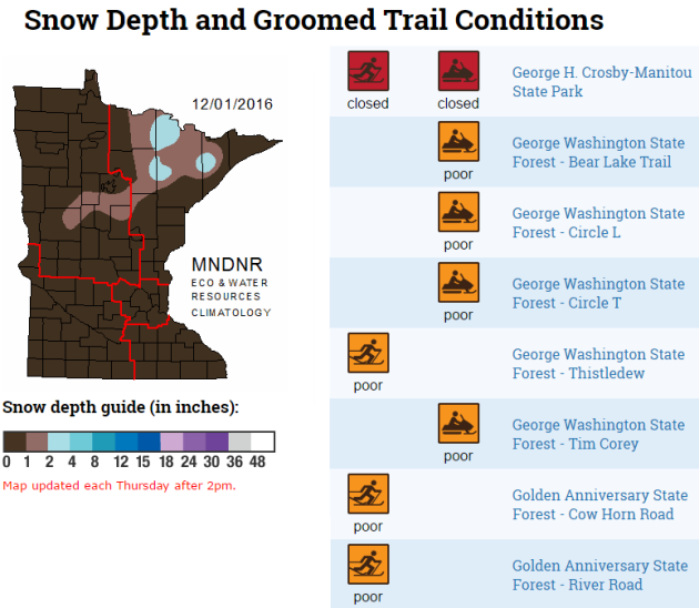
Trail Conditions
Here's another nice product from the MN State Climatology office, which shows updated groomed trail conditions across the state. Note that with very little snow conditions across the state, many trails are either closed or in poor condition.
National Snow Cover
Somewhat Active Pattern With Colder Temps Ahead.
Here's the weather outlook from Saturday to Friday of next week. Note that we seem to have a few shots of light precipitation across the region, but at this point, nothing major is brewing. The big story will be the MUCH colder weather funneling into the region by the 2nd half of the week. This will be some of the coldest air of the season with highs dipping to well below normal temps for a several day period.
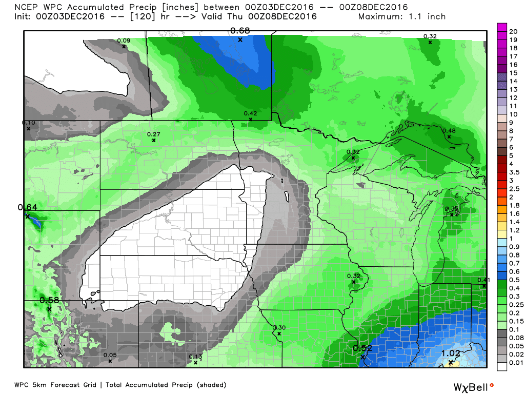
5 Day Precipitation Outlook
The 5 day precipitation outlook through the middle part of next week suggests fairly light precipitation amounts across the Upper Midwest. The heaviest moisture looks to be found across the Ohio Valley and parts of the Great Lakes Region.
______________________________________________________________________________
Welcome to Meteorological Winter... I know the calendar says December, but it sure doesn't look like it. For goodness Pete, my grass is green! I should stir things up a little and fire up the lawn mower, freak out the neighbors a little.
After the 2nd warmest November on record and the warmest October through November on record for the Twin Cities, weather maps are starting to finally look a little more like winter. For the first time since 2013, NOAA's Climate Prediction Center is suggesting cooler than average temperatures across the entire Lower 48 and Alaska at the end of next week! This surge of Arctic air will be some of the coldest air of the season for most across the nation. Ice anglers will be happy as we will finally start seeing skim ice on area lakes. Yes, we're on our way! Now we just need snow for skiers and snowmobilers.
No worries Saturday. Temps will be near average with a little light rain/snow mix moving in Saturday night and Sunday. Temps on Monday warm into the 40s before our first real whack of winter chill.
___________________________________________________
Extended Weather Outlook
FRIDAY NIGHT: Leftover clouds. Winds: WNW 5. Low: 28
SATURDAY: Mostly cloudy, no travel problems. Winds: S 5-10. High: 34
SATURDAY NIGHT: Chance of light snow late. Winds: S 5-10. Low: 30.
SUNDAY: Chance of a light/rain snow mix early. Winds: WSW 5. High: 38
MONDAY: Peeks of AM sun. Few PM showers. Winds: SSW 5-15. Wake-up: 28. High: 42
TUESDAY: Brisk wind, lingering light snow. Winds: WNW 10-20. Wake-up: 28. High: 28
WEDNESDAY: Cold. A few wind-whipped flurries. Winds: W 10-20. Wake-up: 12. High: 19
THURSDAY: Chilly breeze continues. Light snow. Winds: WNW 10-20+ Wake-up: 10. High: 20 (teens for much of Minnesota).
FRIDAY: Less wind. Peeks of PM Sun. Winds: NW 5-10. Wake-up: 16. High: 24.
_______________________________
_______________________________
This Day in Weather History
December 3rd
1998: Albert Lea soars to a record-setting 67 degrees.December 3rd
________________________________
Average High/Low for Minneapolis
December 3rd
Average High: 31F (Record: 62F set in 1962)
Average Low: 17F (Record: -19F set in 1940)
Average Low: 17F (Record: -19F set in 1940)
Record Snowfall: 7.4" set in 1934
_________________________________
_________________________________
Sunrise/Sunset Times for Minneapolis
December 3rd
December 3rd
Sunrise: 7:33am
Sunset: 4:32pm
Sunset: 4:32pm
*Daylight Lost Since Yesterday: ~1mins & 22sec
*Daylight Lost Since Summer Solstice: ~6hours and 36mins
______________________________________________________________________
*Daylight Lost Since Summer Solstice: ~6hours and 36mins
______________________________________________________________________
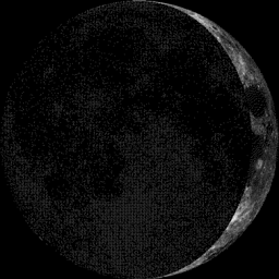
Moon Phase for December 3rd at Midnight
3.1 Days Before First Quarter
3.1 Days Before First Quarter
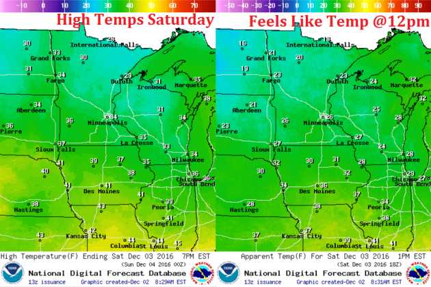
Weather Outlook Saturday
High temps on Saturday will still be running slightly above average levels with many locations warming into the 30s. A few locations across the far north and Arrowhead region will likely hover in the upper 20s to near 30F, which will still be above average by a few degrees.
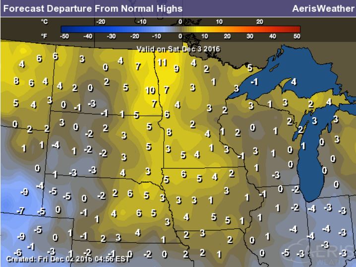
High Temperatures From Average Saturday
Here's a look at high temperatures from average on Saturday and note that many locations across the state of MN will still be running above average. Note that the Red River Valley will be nearly 10F above average! Enjoy the 'warmth' while you can, MUCH cooler weather will be moving in next week.
Weather Outlook Saturday
Winds will not be an issue on during the day Saturday, but they will be a little stronger across far western MN with sustained winds near 10mph with gusts up to 15-20mph! This will be ahead of a weak clipper system that will bring a light rain/snow mix to the region late Saturday into Sunday.
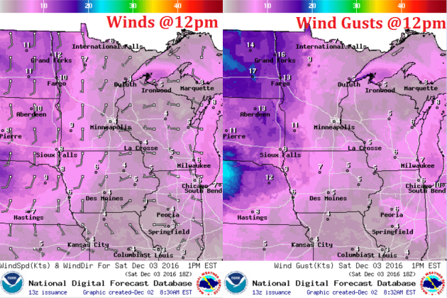
Weather Outlook Saturday
No weather issues are expected during the day Saturday as mostly cloudy skies continue with a few peeks of sun. However, a quick moving clipper system will slide into the region late Saturday/Sunday with a light rain/snow mix.
___________________________________________________________
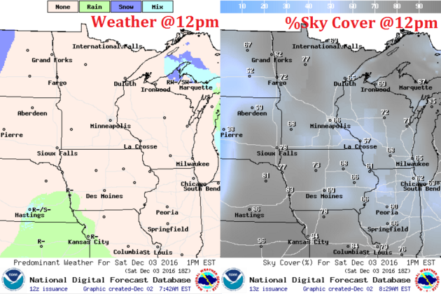
Simulated Radar
The simulated radar from Friday to Sunday shows mostly quiet weather across the region early Saturday, but a quick moving clipper will bring us a quick shot of a light rain/snow mix late Saturday into Sunday.
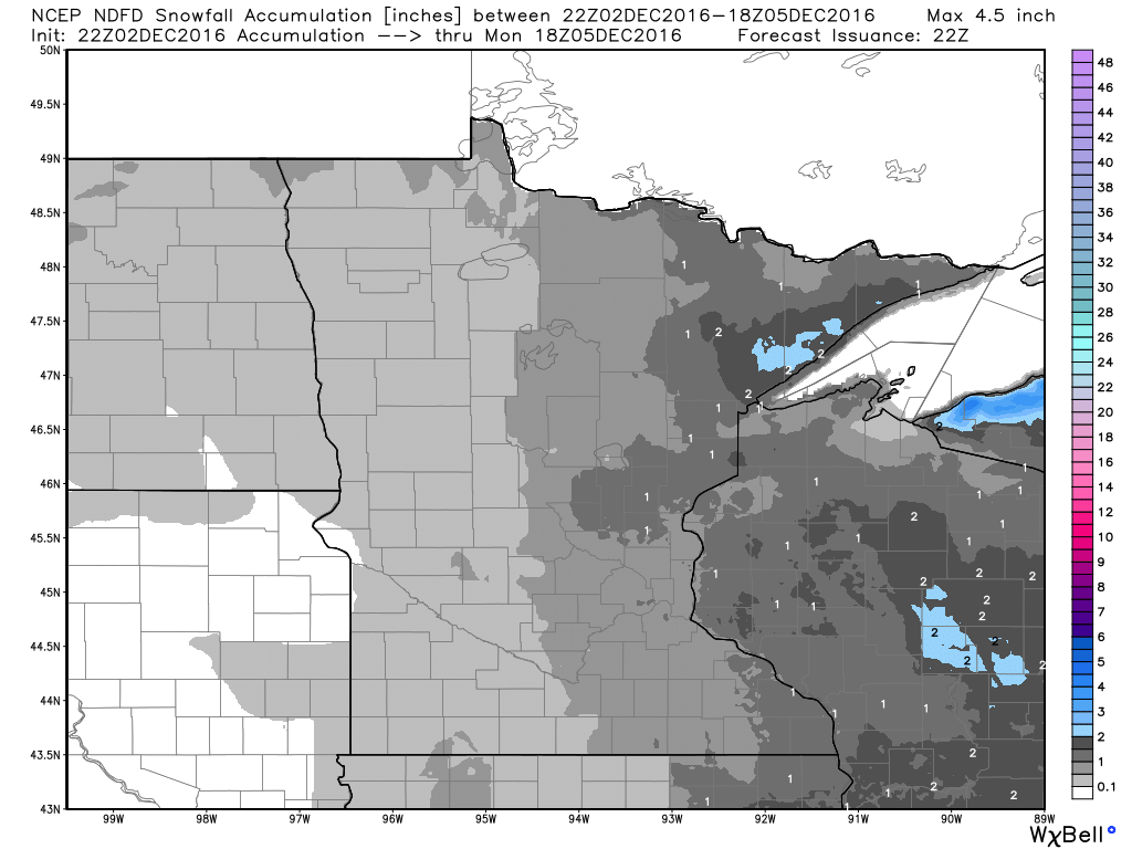
Snowfall Potential
Here's a look a the snowfall potential through midday Monday, which shows VERY light snow chances across the region. It appears that most of us won't see any accumulations, but there could be up to 1" across MN's north shore and into central Wisconsin.
 _______________________________________
Extended Weather Outlook
The temperature outlook for Minneapolis into next weekend shows some big changes coming through the weather pipeline. Note the warming taking place through Monday, but a fiarly significant whack of colder air settles in by the middle and end of next week with highs dipping into the 10s and 20s. Overnight lows will also dip into the single digits and 10s across much of the state.

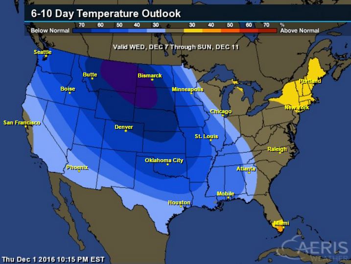
6 to 10 Day Temperature Outlook
According to NOAA's CPC, the 6 to 10 day temperature outlook suggests colder than average temperatures settling into the region as we continue through the first part of December. Note that this will likely be some of the coldest air of the season for many spots across the Upper Midwest.
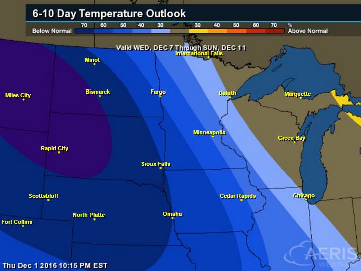
Here's the national temperature outlook from December 7th - December 11th, which shows a big chunk for colder than average temperatures settling into much of the nation. This will be one of the first big colder outbreaks of the season, so get ready!
 __________________________________________
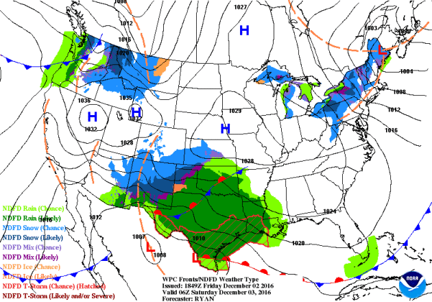
National Weather Outlook
The weather looks to be fairly active across the southern US as we head through the weekend. A large blob of Gulf of Mexico moisture will begin settling into the South-central US with areas of heavy rainfall and scattered storms, some possibly strong to severe into early next week. Meanwhile, heavier moisture in the form of coastal rain and high elevation snow will move into the Pacific Northwest.
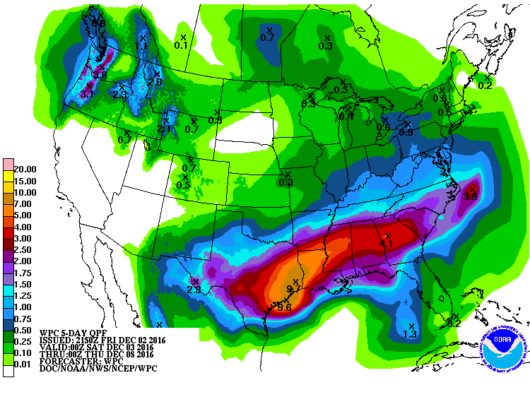
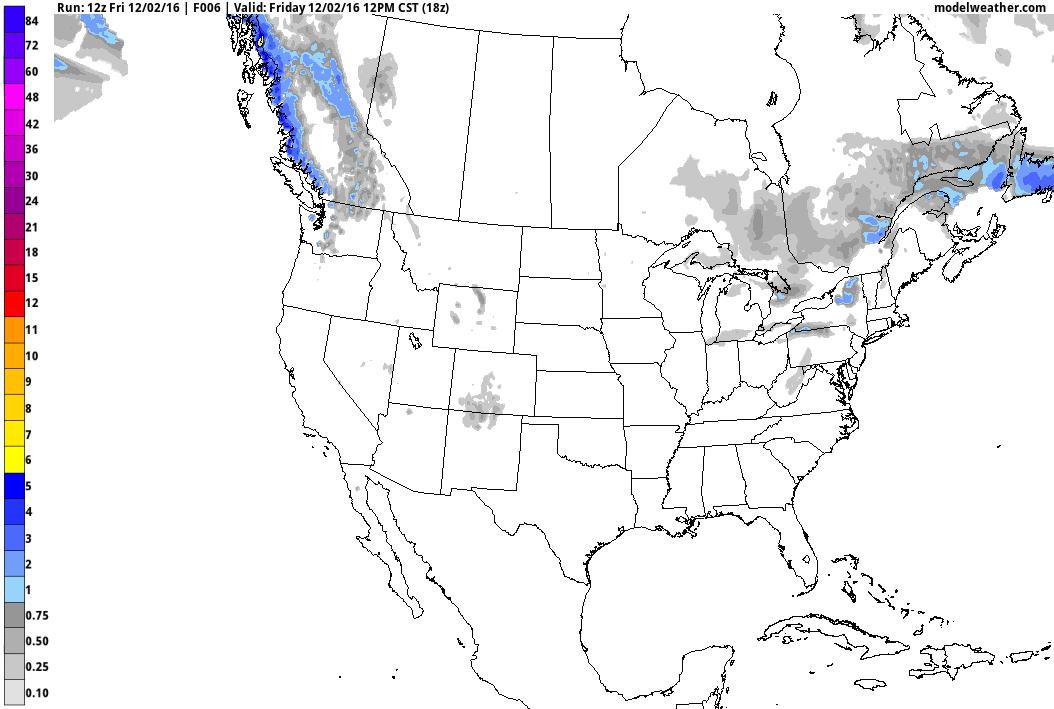
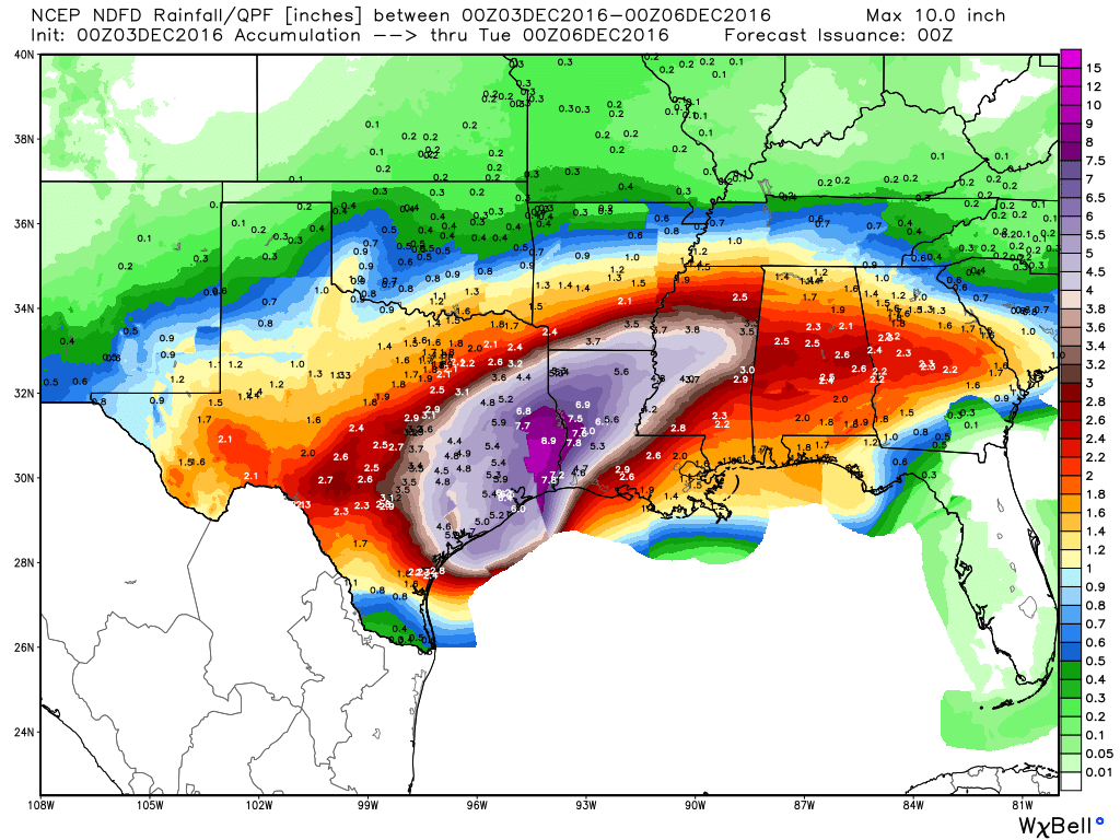
5 Day Precipitation Outlook
According to NOAA's WPC, the 5 day precipitation outlook suggests significant moisture across the southern US through the middle part of next week. Widespread 2" to 4" (isolated 4" to 8") can't be ruled out. This may lead to areas of flooding, but this additional heavy rain will be very beneficial for the drought conditions in the Southeast.
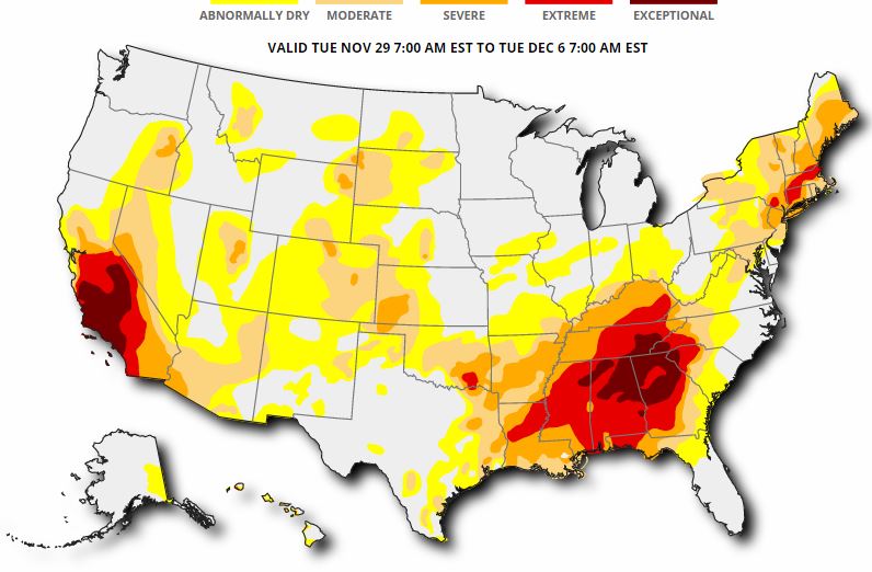
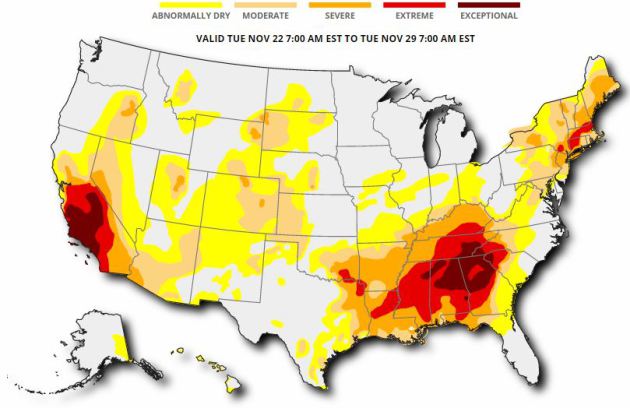
US Drought Monitor
Here's the updated drought monitor from Thursday, December 1st, which shows widespread extreme to exceptional drought conditions across much of the Southeast. While heavy rainfall last week helped some, we need more, so the upcoming heavy rainfall through the first full week of December (next week) is good news!
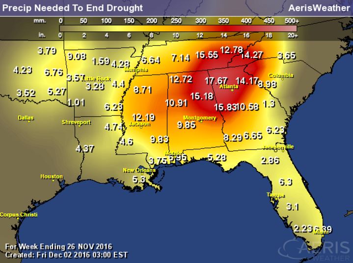
Rainfall Needed to End Drought
The product below suggests how much rainfall is needed to end the drought. Note that many spots need nearly a foot of rain or more to end the drought. These are the areas that are in an extreme to exceptional drought!
National Snowfall Outlook
Here's the potential snowfall through the the middle part of December, which shows the POTENTIAL of heavier snow developing across the northern tier of the nation over the next couple of weeks. This would be a big change from what we had during much of November as it was a generally quiet and warm month across the nation.
Drought Update
According to the US Drought Monitor, 55% of the nation of considered to be abnormally dry, while 17% of the country is in a severe drought, 8% is in an extreme drought and nearly 3% is in an exceptional drought. This is a little worse than it was a week ago. The good news is that we've recently gotten into a more active pattern, so hopefully we'll see some improvement in drought conditions across parts of the nation.
Upcoming Heavy Rain in the South
Take a look at the heavy potential across the southern US through the end of the weekend! Widespread heavy rainfall could lead to areas of flooding over the next few days, especially over eastern Texas and the Lower Mississippi Valley. Not only will heavy rain be possible, but a few strong to severe storms may be possible into early next week as well.
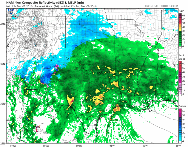
Heavy Southern Rain
Here's a look at the heavy rain potential through PM Sunday. Note that some spots in the eastern part of Texas and into the Lower Mississippi Valley could see up to 3" to 6"+ rainfall.
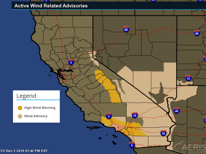
Santa Ana Winds Through PM Saturday
An area of high pressure settling into the Southwest is allowing the Santa Anas to blow. Take a look at the locally strong winds that will be in place over southern California through PM Saturday.
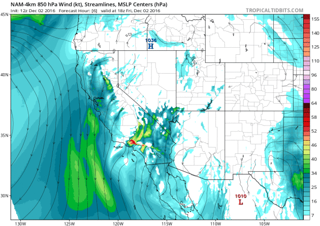
Santa Ana Wind Event Through PM Saturday
...STRONG AND DAMAGING SANTA ANA WINDS EXPECTED THROUGH SATURDAY... .A STRONG SANTA ANA WIND EVENT WILL AFFECT MOST OF LOS ANGELES AND VENTURA COUNTIES THROUGH SATURDAY. WINDS WILL STRENGTHEN THIS MORNING...THEN REMAIN STRONG TO DAMAGING THROUGH SATURDAY AFTERNOON. THE STRONGEST WINDS WILL BE IN THE MOUNTAINS...INCLUDING THE SANTA MONICA MOUNTAINS WHERE DAMAGING PEAK GUSTS TO 80 MPH ARE EXPECTED. THE SANTA CLARITA VALLEY AND EASTERN PORTION OF THE VENTURA COUNTY VALLEYS WILL HAVE DAMAGING WIND GUSTS TO 60 MPH. WIND ADVISORIES ARE IN EFFECT FOR THE REMAINDER OF LOS ANGELES AND VENTURA COUNTIES TODAY THROUGH SATURDAY WHERE GUSTS OF 40 TO 50 MPH ARE EXPECTED. ISOLATED DAMAGING GUSTS TO 60 MPH ARE POSSIBLE NEAR FAVORED FOOTHILL LOCATIONS IN THE NORTHWEST PORTION OF THE SAN FERNANDO VALLEY.
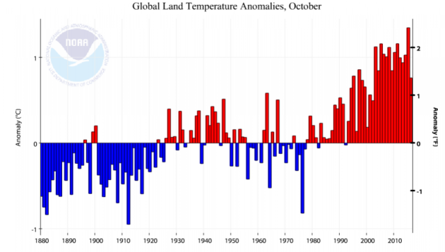
"Earth’s temperature has not plunged at record clip and nationwide record cold not coming"
"Meteorologists and climatologists frequently confront bad information about their science on the Internet and elsewhere. It’s nothing new. But in the past week, particularly egregious claims emerged that have been perpetuated by outlets with large audiences."
These two dubious and deceptive assertions must be dismantled:
1) The global land temperature has just experienced its biggest drop on record.
2) Record cold is predicted for most of the U.S. next week.
"The Earth’s temperature has not crashed at a record pace. The misleading claim that global land temperatures have plunged by a record margin was first reported by David Rose of the Daily Mail last week, and it was amplified today in a piece by James Delingpole at Breitbart News. “Global average temperatures over land have plummeted by more than 1C since the middle of this year — their biggest and steepest fall on record,” Rose’s article begins. Yet it’s easy to explain why this assertion is not only misleading but also pointless. First, Rose’s claim relies on the satellite record of Earth’s temperature estimated from space, which only dates to 1978. The surface-temperature record, which directly measures the planet’s temperature using thermometers and dates to the late 1800s, exhibits a drop but not a record drop."
See more from WashingtonPost HERE:
_____________________________________________________________________________
"Expect Climate Catastrophe: Paris Agreement Lacks Enforcement"
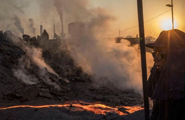
"Enforcement mechanisms for climate change targets are not being implemented, including in the Paris Agreement of December 2015. We are actually sliding backwards on this critical element of a global climate deal. Sanctions were agreed in 2001, that any developed countries that missed emission limits between 2008 and 2012 would have even steeper limits in the future. That has since lapsed. In 2011, all countries agreed that a climate agreement should have “legal force.” Legal force requires an enforcement mechanism, which the Paris Agreement lacks. The E.U. pushed hard for binding targets in the Paris Agreements, including international sanctions for noncompliance. Those did not come about. Bolivia called for an International Climate Justice Tribunal with the mandate to penalize countries for lack of compliance. There is no tribunal in the Paris Agreement. Rather, most developed and emerging economies have systematically resisted international enforcement mechanisms. China (the world’s biggest emissions producer), Russia, the U.S., Canada, India, Japan, Australia, and major energy exporters, resisted the toughest climate change countermeasures over the years, including international monitoring and sanctions. Some in these countries have bemoaned the loss of sovereignty from transparency and enforceable international climate deals. As a result, the 2°C limit in the Paris Agreement on climate change, which started this month, is unenforceable and therefore solely an aspiration if the world can achieve carbon neutrality by 2100. The way things are going, that is unlikely. The Paris Agreement is now among over 500 similarly powerless global and regional environmental agreements. President-elect Trump and other Republicans have dismissed global warming and the international coordination required to stop it. The countries most responsible for lagging in their pledges and policies since the Paris Agreement include Russia, Canada, Japan, Saudi Arabia, and the United Arab Emirates. The U.S., China, India, Brazil, and E.U. countries also lag in their pledges and policies to achieve a climate-neutral future. Those countries that most opposed enforcement, unsurprisingly, also lag in their policy measures to achieve the Paris goals."
{INNER MONGOLIA, CHINA - NOVEMBER 04: A Chinese labourer stands next to a cooling pit at an unauthorized steel factory on November 4, 2016 in Inner Mongolia, China. (Photo by Kevin Frayer/Getty Images)}
__________________________________________________________________
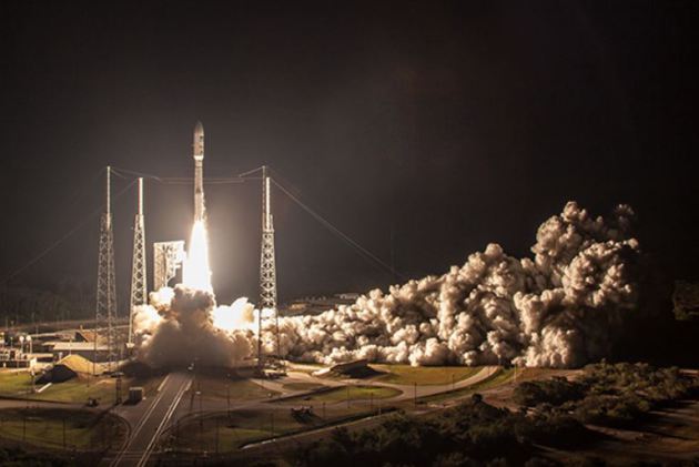
"NOAA satellites go HD with GOES-R"
"Last week, NOAA engineers and satellite mission scientists had something extra to be thankful for: the successful launch of GOES-R on November 19. Providing more timely and accurate information over the Western hemisphere, total lightning mapping, and higher resolution images streaming down from space more often, the new mission marks the first major redesign of the nation’s operational Earth-observing technology in more than 20 years. A Rich History. NOAA’s Geostationary Operational Environmental Satellites (GOES) have served as the foundation of the nation’s near real-time weather and environmental monitoring system since the launch of GOES-1 in 1975. GOES-1 only viewed the Earth every 30 minutes. Our current GOES East and GOES West satellites were launched in 2006 and 2010 respectively, and while they’ve come a long way from the technology of the 70s, all you have to do is think of how much your cell phone has changed since 2006 and you can understand why our weather satellites were due for an upgrade. (Hint: The first generation iPhone came out in 2007). “We’ve been flying operational geostationary satellites for 41 years now, and for the last 22 years we’ve been flying the same basic instrument design,” said Steve Goodman, senior scientist for the GOES-R program. “This is the first major upgrade in 22 years.” GOES-R launched with six key instruments, with two pointing towards the Earth, two focused on the surrounding space environment, and two more keeping an eye on the sun. For monitoring Earth’s weather climate research, it’s the two pointing towards Earth that are the most exciting."
(A United Launch Alliance Atlas V 541 lifts off with NASA's GOES-R satellite. GOES-R is the first of four satellites to be launched for NOAA in a new and advanced series of spacecraft. Once in geostationary orbit, it will be known as GOES-16. Taken on November 19, 2016. Credit: United Launch Alliance.)
_____________________________________________________________________________
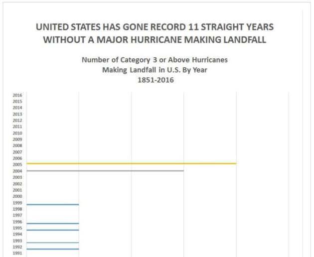
"NOAA: Record 11th Hurricane Season Ends Without Major Strike on U.S."
"As November 2016 ended, the United Sates completed a record 11 straight hurricane seasons without a major hurricane striking the U.S. mainland, according to the National Oceanic and Atmospheric Administration. An unprecedented 11 years, one month and seven days has passed since the last major hurricane struck the U.S. mainland, according to data going back to 1851compiled by NOAA. “The 2016 hurricane season will end officially on November 30. Hurricane Wilma was the last major hurricane (on the Saffir-Simpson Hurricane Wind Scale) to strike the U.S. (October 24, 2005),” NOAA spokesman Dennis Feltgen told CNSNews.com. Major hurricanes, defined on the scale as a Category 3 or above, are characterized by wind speeds of 111 mph or higher and strong storm surges capable of causing “devastating” or “catastrophic” damage. “It is important to note that this scale covers only the wind impact,” Feltgen noted. “It has nothing to do with the water impact, which accounts for nearly 90 percent of the fatalities - 50 percent of which occur from storm surge and 25 percent from inland flooding."
(Image credit: NOAA)
___________________________________________________________________________
Homesick For Minnesota Candle
Looking for a good XMAS present? How about these homesick candles. There's one for every state! Here's Minnesotas:
"Takes you back to The North Star State, with scents reminiscent of winter air and Minnesota apple strudel"


No comments:
Post a Comment