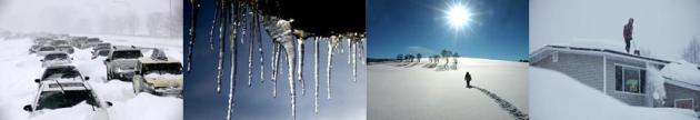
10 F. high temperature yesterday in St. Cloud.
21 F. average high on January 12.
1 F. maximum temperature on January 12, 2016.
January 13, 1916: The high temperature in the Twin Cities only reaches a frigid -14 degrees.
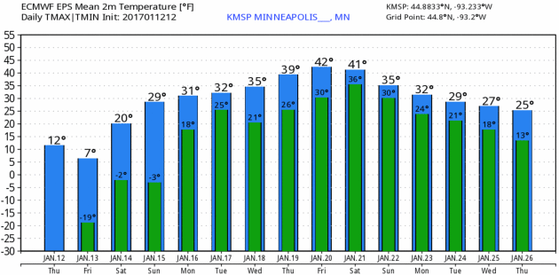
Temperatures Bottom Out - January Thaw Next Week!Numb
and Number, The Sequel. Welcome to the coldest morning since December
18, 2016, when the official low at MSP was a crisp -20F. We're waking up
to -10 to -15F in the close-in suburbs, where the urban heat island is
taking some of the edge off the burn.
Winds are nearly calm, so
the wind chill won't be much colder than the actual air temperature.
Even so, unprotected skin can be frostbitten
within 10 minutes.
At -40F exposed skin freezes
within 1 minute;
at -60F (hello Tower, Minnesota!) exposed skin can freeze within
seconds. When it's that cold your breath turns to ice crystals that fall
to the ground. Really.
The MSP metro area has picked up 23 inches
of snow this winter; a whopping 4 inches on the ground. A far cry from
January, 1982, when snow lovers were delirious, with 38 inches to
report!
Word to the wise: get out and play in that new Minnesota powder this weekend. We thaw out by
Monday, when a light mix arrives. ECMWF guidance hints at 40F late next week; more rain by the weekend of
January 21-22.
Rain? Hard to fathom on a brisk, invigorating morning like this.
 Thump Your Chest!
And here it is, the reason so many American's eyes get big when
pondering what Minnesota is like in January. "How do you live out
there?" Well, I hold my breath a lot and try not to lick metal objects.
"What does it feel like?" Like being dipped headfirst into a vat of mild
acid - a slight burning sensation that makes you want to check and see
if you still have all your fingers and toes. Then again I've been more
uncomfortable at grade school assemblies, and this cold sting won't last nearly as long. 30s return next week;
the atmosphere warm enough for a light mix by Monday and Tuesday. We
keep oscillating between subzero and March temperatures with rain. Odd,
to say the least.
Warming Trend.
Hard to believe, but if ECMWF guidance is on the right track it may be
50-55F warmer here within a week. Not sure we'll really see 40F but a
streak of 30s seems imminent. Source: WeatherBell.
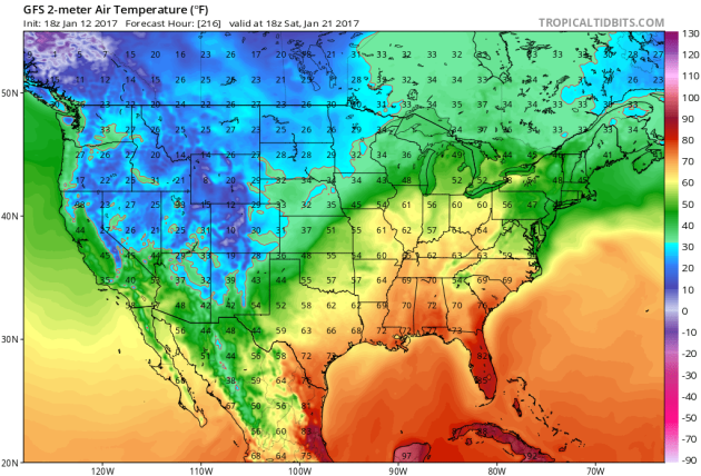
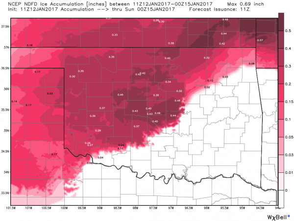
 Ice Storm Develops
.
The 84-hour 12 KM NAM model shows a smear of ice developing near
Wichita, spreading toward St. Louis, Champaign-Urbana and Indianapolis
as surface temperatures should be cold enough for rain to freeze on
contact. California gets a brief break, but another big storm will whack
the west coast the latter half of next week. Animation:
Tropicaltidbits.com.
Hints of March Next Week.
The west coast remains unusually chilly, but 60s are forecast to push
as far north as Chicago 1 week from Saturday with 70s in the Mid South
and 80s across Florida, according to GFS data. Old Man Winter takes a
breather, although the weather has been anything but harsh for most of
the south and east this winter, with only a few exceptions.
 Excessive Salt Use is Hurting Minnesota Lakes, State Officials Warn
. Here's an excerpt from
Lake Minnetonka Patch: "...
There
are currently 47 waterbodies in Minnesota that tested above the water
quality standard for chloride, with 39 in the metro. An additional 39
surface waters in the metro are near the chloride standard and many
others are unknown. The data show that salt concentrations are
continuing to increase in both surface waters and groundwater across the
state. Currently, there are no environmentally safe, effective and
inexpensive alternatives to salt. However, officials say residents can
reduce salt at the source through smart salting application strategies..."
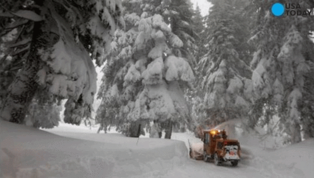
Too Much Snow Closes Ski Resorts in California, Nevada.
USA Today reports: "
Instead
of bringing delight to skiers and snowboarders eager for fresh powder,
the intense snowstorms that buried the mountains of California and
Nevada under up to 10 feet of snow this week instead caused several
winter resorts to close. The massive amount of snow combined with high
winds and road closures on Wednesday again shut down the Woodward Tahoe
Ski Area in California, which referred to the storm as
#Snowpocalypse2017. Nine feet of snow in three days also shuttered
California's Kirkwood Mountain Resort in California, and road closures
and other complications from the storm likewise left Nevada's Mt. Rose
Ski Tahoe not welcoming the normal stream of winter enthusiasts..."
Photo credit: "
Heavy
rain and snowfall hit parts of California, Nevada and Oregon early on
Wednesday, causing roads to be closed, schools to cancel classes and
widespread flooding along already swollen waterways."
USA TODAY NETWORK.
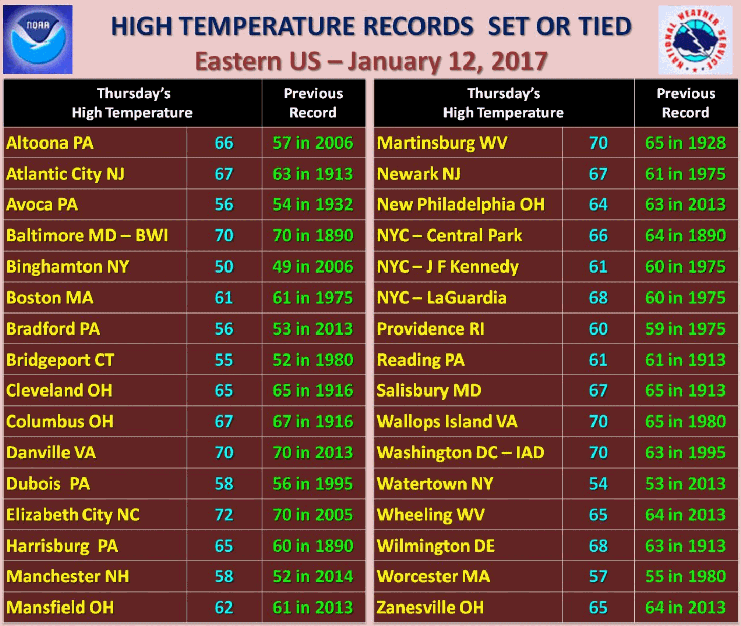 Meanwhile - Record Warmth Out East. Check out a long list of record highs on Thursday. Amazing.
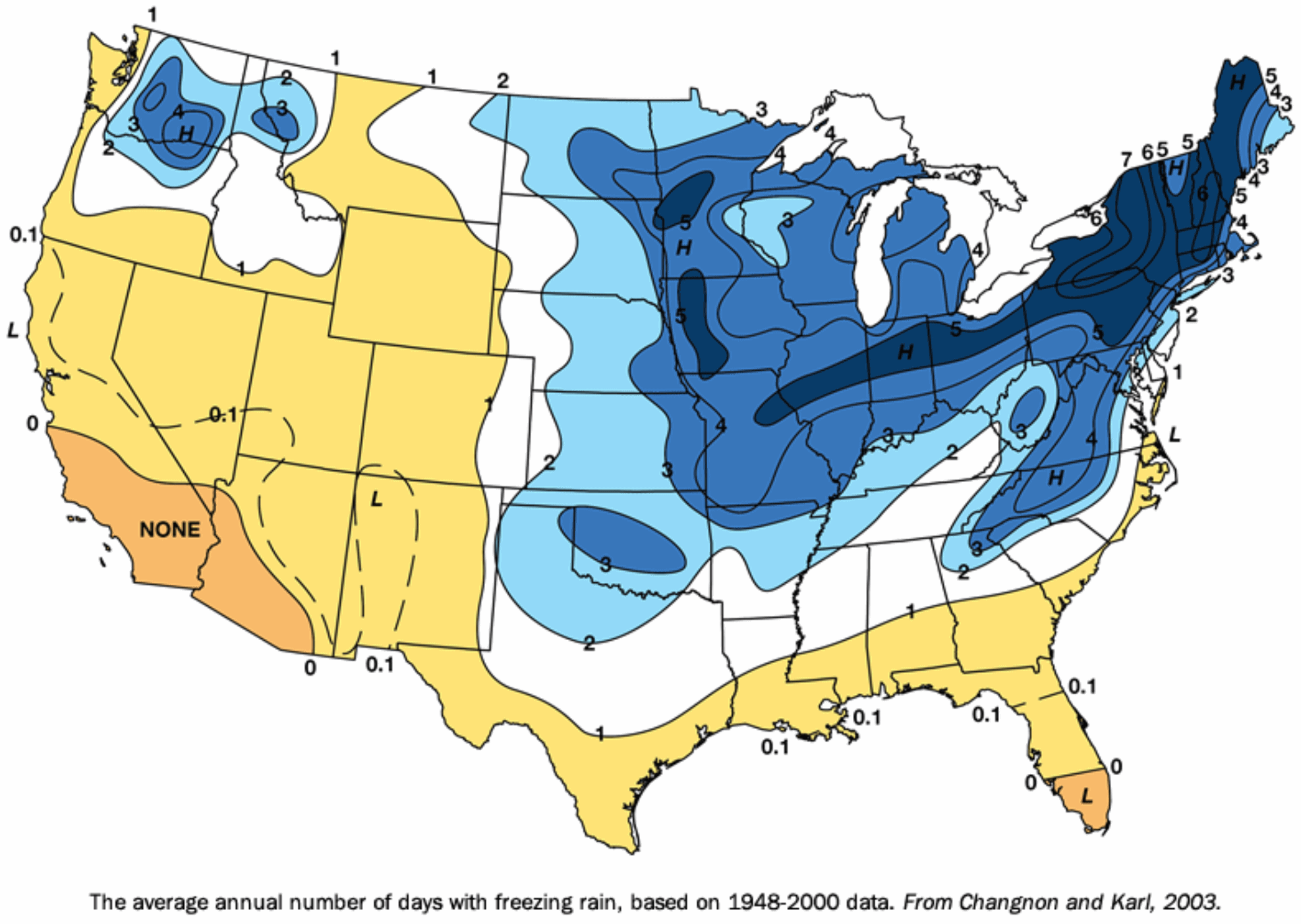 Climatology of Freezing Rain.
Minnesota sees about 3-5 days a year with freezing rain (glaze ice).
But the greatest frequency is found in New England. Here's an excerpt
from Midwestern Regional Climate Center: "The
Midwest and Northeast are prime areas for freezing rain events. Note
the high frequency areas in western Minnesota and western Iowa, and the
band from central Illinois eastward through northern Indiana, Ohio, and
eastward. In the high frequency band in the Midwest, an average of 12
to 15 hours of freezing rain occurs annually. While freezing rain can
occur anytime between November and April, most freezing rain events
occur during December and January
Climatology of Freezing Rain.
Minnesota sees about 3-5 days a year with freezing rain (glaze ice).
But the greatest frequency is found in New England. Here's an excerpt
from Midwestern Regional Climate Center: "The
Midwest and Northeast are prime areas for freezing rain events. Note
the high frequency areas in western Minnesota and western Iowa, and the
band from central Illinois eastward through northern Indiana, Ohio, and
eastward. In the high frequency band in the Midwest, an average of 12
to 15 hours of freezing rain occurs annually. While freezing rain can
occur anytime between November and April, most freezing rain events
occur during December and January...."
AerisWeather Briefing: Issued Thursday morning, January 12
th, 2017
*
A major ice storm is shaping up for the end of the week and into the
early weekend for areas from northern Texas into the Ohio Valley.
*
Ice accumulations of at least a quarter to a half an inch will be
possible across portions of this region. Current forecasts show the
potential of three quarters of an inch or more of ice across parts of
Oklahoma, Kansas and Missouri.
*
Ice accumulations of this
magnitude would cause significant travel issues, with the potential of
many roads becoming ice covered making travel impossible. This
significant icing would accumulate on trees and power lines, leading to
power outages.
* Winter Storm Watches are now in place from northern Texas to Illinois for the significant icing threat. These watches include
Oklahoma City, Wichita, Dodge City, Kansas City, and St. Louis.
Ice Storm Potential.
A long duration ice storm is shaping up as we head into the weekend
from Texas to the Ohio Valley as warm, moist air surges north over
temperatures that will be closer to freezing near the surface. In some
of these areas, we could see at least a quarter to a half an inch of
ice, which would lead to tree and power line damage as well as
impossible travel conditions.
Winter Storm Watches In Place.
Due to the significant icing expected as we head into the end of the
week and the weekend, Winter Storm Watches have been issued from
northern Texas to Illinois. Expect a number of these to be upgraded to
Ice Storm Warnings as we head through the next several days.
Forecast Ice Totals - Oklahoma. This is a snapshot of forecast ice totals through
Saturday evening across Oklahoma. While some more freezing rain will be possible
Saturday
Night, particularly across northern and western Oklahoma, at least a
quarter inch or more of ice is possible as far south as the Oklahoma
City metro through
Saturday. In Oklahoma City, freezing rain will start
tonight and last on and off into
Saturday. Some rain may mix in
tomorrow depending on where the freezing line sits, but heading into
Saturday enough warm air looks to move in to change it to all rain through the end of the weekend.
Forecast Ice Totals - Kansas. Across Kansas, the heaviest ice accumulation will be across parts of south-central and southeast Kansas through
Saturday Night, where over a half an inch of ice could be possible. For Dodge City, the chance of freezing rain moves in
Friday Night and the threat lasts into
Sunday. In Wichita, the freezing rain threat begins
Friday and lasts into
Sunday, with regular rain mixing in both
Saturday and
Sunday. Map credit: WeatherBell.
Forecast Ice Totals - Missouri.
Missouri is where some of the heaviest ice could fall as we head
through the weekend, with the potential of over a half of an inch of ice
from Joplin to across central areas of the state. St. Louis could see
between a quarter and a half an inch of ice, with Kansas City picking up
around a quarter inch. In St. Louis, freezing rain will start off
during the day
on Friday and last into
Sunday, with the heaviest ice accumulation expected
Friday Night. In Kansas City, the freezing rain potential will begin
Friday Night and last until midday
on Sunday, with some of the heaviest ice accumulation occurring
Saturday Night into early
Sunday.
Probability Of 0.10"+ Ice Through Sunday Morning.
There is at least a 50% chance of at least a tenth of an inch of ice
from northern Texas into central Illinois as we head into early
Sunday
morning, with the best chance of accumulating ice across portions of
Oklahoma, Kansas and Missouri. It is also important to note the
potential of freezing rain as far east as Washington D.C.
Friday Night and
Saturday.
This amount of ice is enough to cause trouble on the roads and put a
coating on trees and powerlines, which could start to weigh them down.
Map credit: NOAA.
Probability Of 0.25"+ Ice Through Sunday Morning.
There is at least a 40% chance of at least a quarter inch of ice from
Dodge City, KS westward to Jefferson City, MO, and south to Bartlesville
and Ponca City in Oklahoma. The highest probability of at least a
quarter inch of ice is across eastern Kansas and western Missouri.
Ice
accumulations of this magnitude would cause significant travel issues,
with the potential of many roads becoming ice covered making travel
impossible. This significant icing would accumulate on trees and power
lines, leading to power outages.
Summary: A potentially crippling ice storm is on track as we head into
Friday
and the weekend for parts of the central and southern Plains, with ice
accumulations of at least a quarter to a half an inch possible from
Oklahoma to Missouri. Winter Storm Watches have been issued from
northern Texas to Illinois for this significant icing threat. These
watches include
Oklahoma City, Wichita, Dodge City, Kansas City, and St. Louis.
Ice accumulations of this magnitude would cause significant travel
issues, with the potential of many roads becoming ice covered making
travel impossible. This significant icing would accumulate on trees and
power lines, leading to power outages. This would have the potential to
greatly disrupt operations through the weekend and into early next week,
depending on how fast power companies would be able to get power back
up.
D.J. Kayser, Meteorologist, AerisWeather
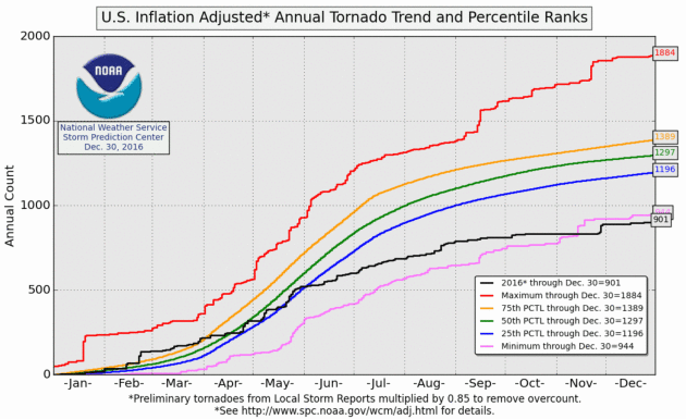
Will a 5 Year U.S. Tornado Drought End in 2017? Andrew Siffert includes some good news with his comprehensive overview at
BMS Media Centre: "...
When
the calendar flipped to 2017, a switch seemed to turned on for US
severe weather season: severe weather impacted the Gulf Coast states
with 31 tornadoes on January 2 (PCS 1711). Just two weeks into the year, 2017 already has 4.4 times more than the normal number of tornadoes.
However, the great news is that 2016 ended with lower reported tornado
numbers, and the preliminary numbers suggest that 2016 ended up as a
year with the fewest tornadoes since 1954 (when records started)..."
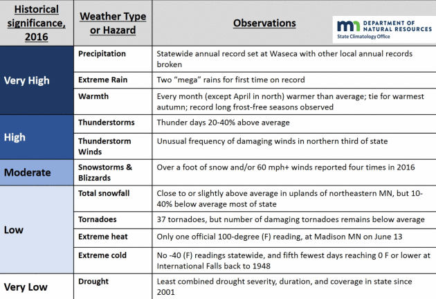
Top 5 Weather Events of 2016 in Minnesota.
The Minnesota DNR has the list; here are the top 2 weather events of last year: "
Here
are the results of voting for the top five weather events of 2016 from
the Minnesota State Climatology Office. Votes were cast from various
weather enthusiasts including the National Weather Service, the
University of Minnesota, State agencies and Facebook followers...
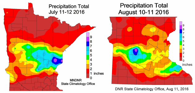
#2 Central Minnesota Flash Flood July 11-12, 2016
The largest flash flood in Minnesota since the event of June 19-20, 2012
struck part of the same region on July 11-12, 2016. The highest two-day
total was a volunteer reader in Pine County with 9.34 inches.
Southbound I-35 and Highway 61 was closed for a time on July 12. The
area covered by six inches or more of rainfall exceeded 2,000 square
miles, qualifying it as a "Mega Rain" event. The flooding would have
been worse had it not been for the relatively dry conditions beforehand.
In addition to the heavy rain, there were three tornadoes, two of which
were EF2. .
#1 State Record Precipitation Total at Waseca and Record Annual Twin Cities Precipitation.
The
event that garnered the most votes was the statewide annual
precipitation record set at Waseca and the Twin Cities annual record
precipitation. The preliminary 2016 precipitation total at Waseca is
56.24 inches, handily breaking the old record at St. Francis in Anoka
County of 53.52 inches in 1991. The 2016 total at Waseca breaks the old
record by 2.72 inches. The Twin Cities also broke the annual
precipitation record that was set over 100 years ago. The preliminary
total for 2016 is 40.32 inches, breaking the old record of 40.15 inches
set in 1911. The precipitation record for the Twin Cities begins in
1871..."
Map credit: Minnesota DNR, State Climate
Office. The July 11-12 "Mega-Rain" was one of 2 mega-rain events of
2016; the first time on record Minnesota has experienced 2 such
widespread flood events.
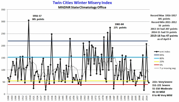
Winter Weather Misery Index: This Is Still a "Mild" Winter.
The arctic smacks and snow bursts have been evened out by 30s and rain.
Factoring in snowfall and temperature it hasn't been that bad, at least
not yet. That said, I think we'll at least wind up in the "moderate"
range by the end of meteorological winter. Here's an excerpt from the
Minnesota DNR: "..
As of January 10, 2017 the WMI for the 2016-17 winter is at 41 points:
19 points for cold, 22 points for snow. This is enough for this winter
to be in the "mild" category. Fourteen more points are needed for this
winter to be categorized as "moderate." The WMI for the winter of
2015-16 finished with 47 points,
enough for 2014-15 to be categorized as a "mild" winter. The WMI points
for the 2015-2016 winter were 18 for cold and 29 snow: 46 points. The
winter of 2016-17 should easily pass last winter in points. The WMI for
the winter of 2013-14 in Twin Cities was 207
points, or in the high end of the "severe winter" category. This was
the 9th most severe winter on record based on WMI points. The lowest WMI
score was the winter of 2011-2012 with 16 points. The most severe
winter is 1916-1917 with 305 WMI points. Note, this could also be called
the "Winter Fun Index" depending on your perspective!..."
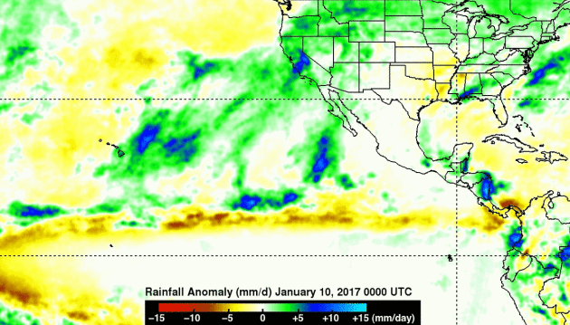
Pineapple Express Delivers Heavy Rains, Flooding, Drought Relief to California. Here's an excerpt of a
NASA article that delves into atmospheric rivers and the mixed atmospheric blessing now underway in California: "
California,
which has long been suffering through a strong, multi-year drought, is
finally beginning to see some much needed relief as a result of a recent
series of storms that are part of a weather pattern known as the
“Pineapple Express.” The Pineapple Express is known as an atmospheric
river. A large, slow-moving low pressure center off of the West Coast
taps into tropical moisture originating from as far south as the
Hawaiian Islands. This moisture is then channeled northeast by the
subtropical jet steam towards the West Coast where the topography aids
in squeezing out the moisture as air flows over the mountain ranges.
Though these rains are certainly welcome and very much needed, they have
also led to flooding and mudslides. The first storm in the series
arrived in the middle of last week and brought rain to northern and
central California. The next storm occurred over the weekend and brought
heavy rains again to mostly northern and central California although
southern California also received significant amounts. This event lead
to widespread flooding, down trees and mudslides, especially in the
Sierra Nevada where hurricane force winds occurred and Interstate 80 was
closed due to a massive mudslide..."
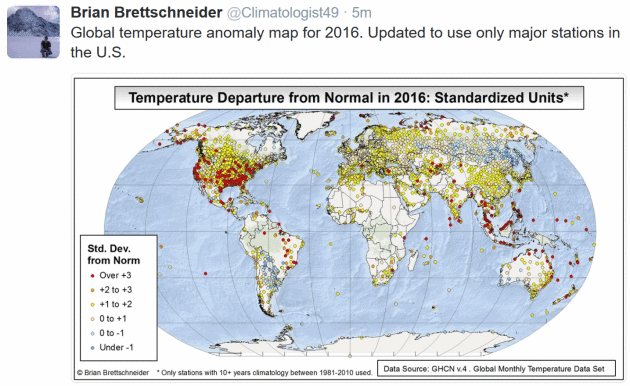
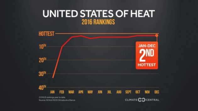
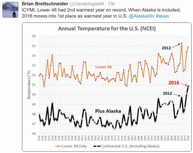
It's Official: 2016 Was Second Hottest Year for U.S. Only 2012 was warmer.
Climate Central reports: "
2016 was the second hottest year for the U.S. in more than 120 years of record keeping, government scientists announced on Monday,
marking 20 above-average years in a row. Every state had a temperature
ranking at least in the top seven, with two, Georgia and Alaska,
recording their hottest year. The announcement comes a week before the
National Oceanic and Atmospheric Administration, which released the U.S.
data, and NASA are expected to announce that 2016 set the record for
the hottest year globally. Both the global record and the U.S. near-record are largely attributable to greenhouse gas-driven warming of the planet..."
Command and Control.
The book was amazing, and now PBS's American Experience has turned it
into a must-see documentary. There have been over 1,000 accidents
involving nuclear warheads since the 1950s. Let that statistic sink in.
We've just been very, very lucky.
Stream it online here: "
A
chilling nightmare plays out at a Titan II missile complex in Arkansas
in September, 1980. A worker accidentally drops a socket, puncturing the
fuel tank of an intercontinental ballistic missile carrying the most
powerful nuclear warhead in our arsenal, an incident which ignites a
series of feverish efforts to avoid a deadly disaster. Directed by
Robert Kenner (FOOD, INC.) and based on the critically acclaimed book by
Eric Schlosser (FAST FOOD NATION), COMMAND AND CONTROL is a
minute-by-minute account of this long-hidden story. Putting a camera
where there was no camera that night, Kenner brings this nonfiction
thriller to life with stunning original footage shot in a decommissioned
Titan II missile silo. Eyewitness accounts — from the man who dropped
the socket, to the man who designed the warhead, to the Secretary of
Defense— chronicle nine hours of terror that prevented an explosion 600
times more powerful than Hiroshima."
Netflix for Cars; $1,500/month To Drive Any Cadillac, Anytime.
Like every other industry, the car industry is being disrupted. This is
an interesting concept, initially available in New York City - focusing
on people who want a little variety in their vehicle diet. Here's an
excerpt from
The Washington Post: "
In what AdAge is calling
a “Netflix for cars,” Cadillac has launched a program that it says is a
“first-of-its-kind luxury vehicle subscription service.” The program is
called Book by Cadillac and here’s how it works: For starters,
customers are no longer customers. They’re now “members.” A member pays a
flat monthly fee of $1,500 (there’s also a one-time $500 initiation and
processing fee). For all this, the member gets unlimited access to
several Cadillacs – from the V Series, XT5 and CT6 to an Escalade – for
as long and whenever wanted. These same cars would cost between $60,000
and $100,00 if purchased outright, according to a Reuters report.
The car is home delivered and the fee includes registration, taxes,
insurance and maintenance costs. There’s no mileage limit and if you
want out of the program you just have to give 30 days’ notice..."
Press release from Cadillac is
here.
All of Las Vegas's City-Owned Buildings Now Run on Renewable Energy.
Motherboard has the story: "
Las
Vegas is best known for its blinding neon signs and indulgent venues,
but more recently the city government has set its sights on keeping the
lights on in a more sustainable way. Las Vegas’s city-owned buildings
and other public infrastructure are now entirely powered by renewable
energy as of December, including about 48,000 streetlamps, lights inside
City Hall and power at city parks, Las Vegas spokesman Jace Radke said..."
Start-Up Company That Wants to Recycle Electric Batteries On Display at Detroit Auto Show.
WXYZ-TV in Detroit reports: "...
One
company is showcasing a new way to reuse electric car batteries. Shiv
Rajendran of Totus Power said, "We actually take somebody else's waste
and use it to provide electricity to people in developing countries."
That's the mission behind Totus Power. Shiv, an electrical engineer, has
found a way to make electric cars even more green. He takes used
electric batteries that would've been throw out and gives them another
purpose. "They are not actually dead, they just don't have the power to
run a car, but they are almost as good as new for running tablets, cell
phones, laptops, essentially replacing the lead-acid batteries that the
majority of the people in developing countries use," he explained..."
 Report Ranks Iowa as Top State for Corporate Access to Clean Energy. Midwest Energy News
 reports: "
According
to a new report, companies looking for easy access to renewable energy
should consider moving to Iowa. That state, followed by Illinois, topped
a ranking released Tuesday
by the nation’s retail and tech sectors urging state governments to
lower barriers to the further development of renewable energy. Ohio came
in 8th. The report, assembled by Clean Edge on behalf of the Retail
Industry Leaders Association and the Information Technology Industry
Council, comes just as state legislatures across the country are
convening for their 2017 sessions. The report was quite clear about its
intentions: to urge changes in state laws and regulations regarding
renewable energy, and especially corporate access to it..."
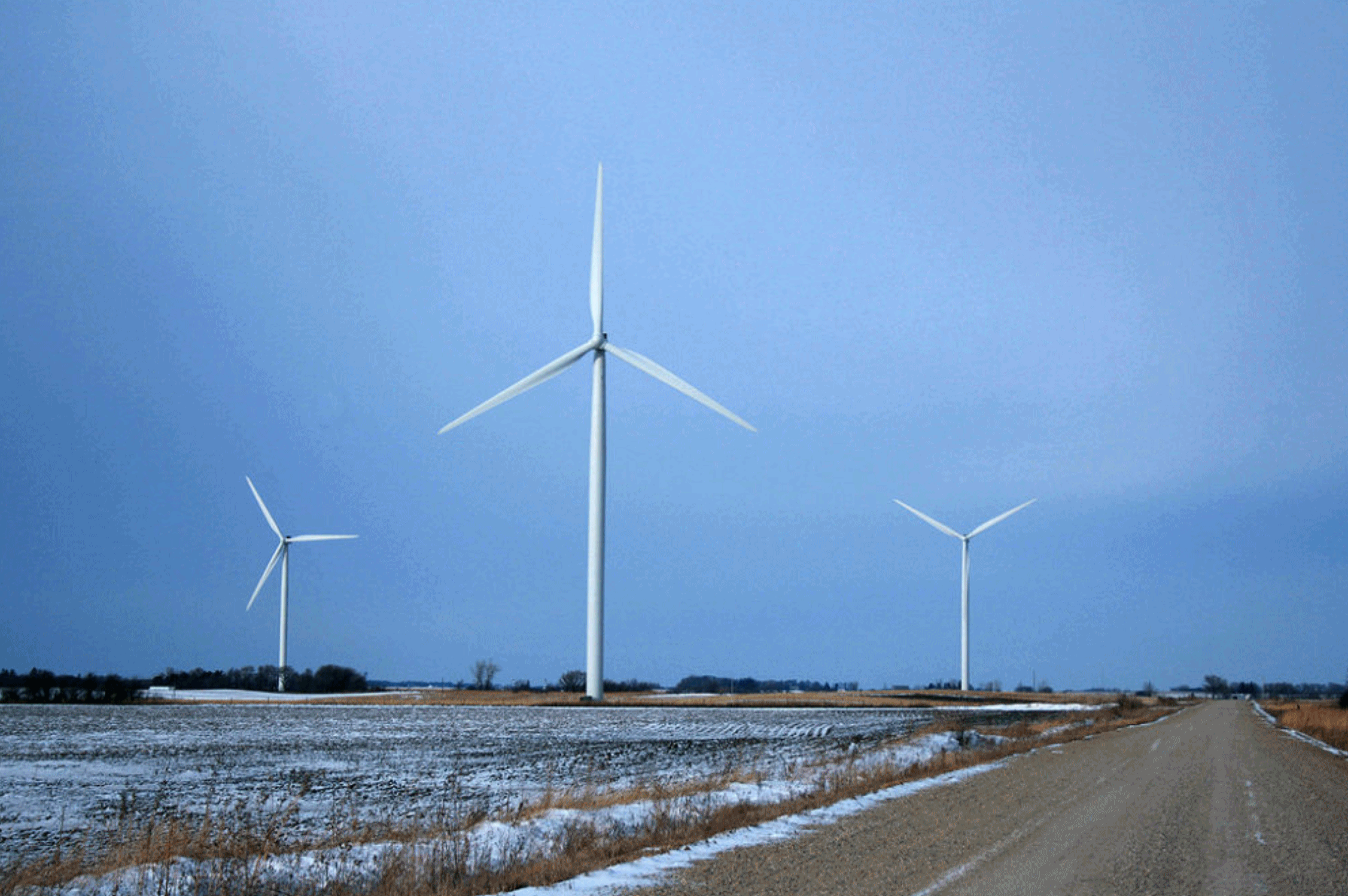
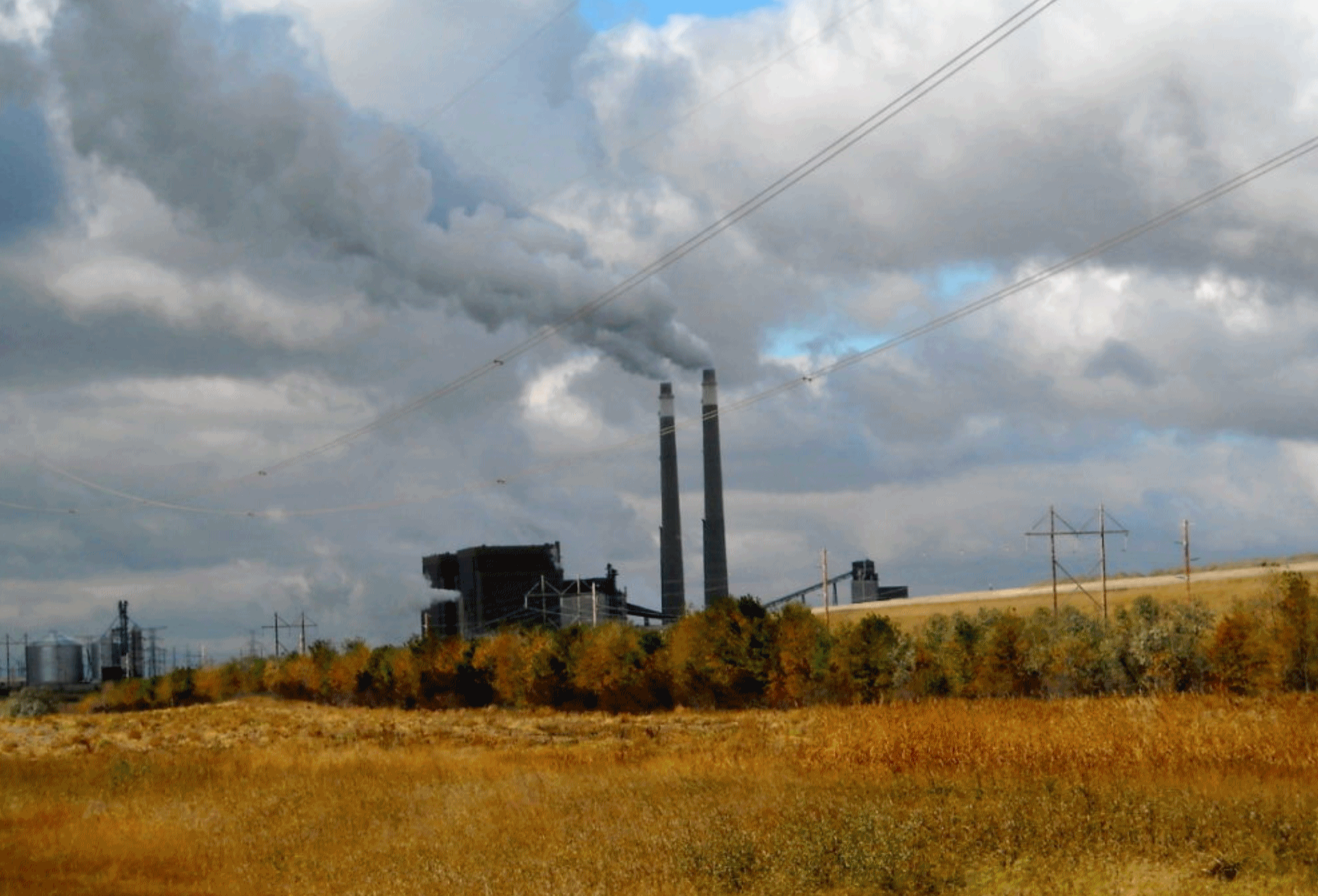 Minnesota Utility Sees Declining Returns in Coal Power Generation. Midwest Energy News
 reports: "
Minnesota’s
second biggest utility, Great River Energy, has begun to significantly
ramp down the output of its largest coal plant as the market has shifted
to wind power and natural gas production. The transmission utility’s Coal Creek Station,
located 50 miles north of Bismarck, North Dakota, can produce 1,100
megawatts (MWs) of electricity. That makes it the largest power plant in
North Dakota and by far the biggest in Great River Energy’s
system. Currently, though, the plant operates at less than a third of
its full output in times of high wind production – spring and fall – as
the cost of having it operate at full capacity costs the company money.
Some days the plant produces less than 300 MW..."
How Netlfix is Deepening Our Cultural Echo Chambers.
The New York Times has an interesting article; here's an excerpt: "...
Instead,
we’re returning to the cultural era that predated radio and TV, an era
in which entertainment was fragmented and bespoke, and satisfying a
niche was a greater economic imperative than entertaining the
mainstream. “We’re back to normal, in a way, because before there was
broadcasting, there wasn’t much of a shared culture,” said Lance Strate,
a professor of communication at Fordham University. “For most of the
history of civilization, there was nothing like TV. It was a really odd
moment in history to have so many people watching the same thing at the
same time...” (Image credit:
Doug Chayka)
It's More Expensive Than Ever To Raise a Child in the U.S. It's a big number, according to
The Washington Post: "
It’s
more expensive than ever to raise a child in the United States, where
families will shell out an average of $233,610 from birth through age 17
— or about $13,000 a year — according to new figures from the
government. The ballooning price tag, a 3 percent increase from a year
earlier, comes at a time when day-care costs can exceed university tuitions and homes prices have skyrocketed to record highs.
Families in urban areas in the Northeast, such as New York and Boston,
were likely to pay even more — an average of $253,770, or roughly
$14,000 a year — because of higher housing and child-care costs,
according to a report by the Department of Agriculture..."
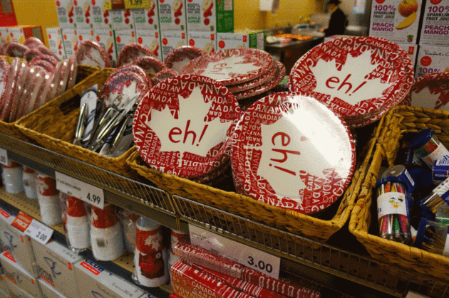
Why Do Canadians Say "Eh"? I learned something today, thanks to
Atlas Obscura: "...
Jack Chambers, a linguist at the University of Toronto,
writes that these “ehs” are all of a piece. “All of these uses have one
pragmatic purpose in common: they all show politeness,” he wrote in a
2014 paper. Using “eh” to end the statement of an opinion or an
explanation is a way for the speaker to express solidarity with the
listener. It’s not exactly asking for reassurance or confirmation, but
it’s not far off: the speaker is basically saying, hey, we’re on the
same page here, we agree on this. Even in the use of “eh” as a criticism
or a command, the word seeks to find common ground. If I say “you’re an
idiot, eh?”, what I’m saying is, you’re an idiot, but you should also
think you’re an idiot, and our understanding of you as an idiot finds us
on common ground..."
Photo credit: "
Canada Day items on sale in Nova Scotia."
Nicole Bratt/CC BY-SA 2.0
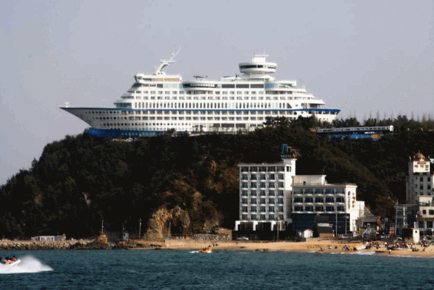
Hotel or Cruise Gone Bad? It turns out it's a luxury hotel, shaped like a cruise ship. Ah!
Atlas Obscura clears up any lingering confusion: "...
Believed
to be the world’s first hotel designed as a cruise ship, the Sun Cruise
Resort and Yacht is over 500 feet long and nearly 150 feet tall.
Complete with 211 rooms, six restaurants, a sculpture garden, and a
volleyball court, the giant misplaced boat sits peculiarly atop a tall
cliff to give the impression that it’s run aground. The resort is known
throughout the region for its eye-catching appeal, and it takes full
advantage by playing the sounds of bird calls and oceanic waves to mimic
the actual experience of sailing on a cruise liner without the
consequential seasickness..."
TODAY: Numb-ish. Patchy clouds, few flakes? Cold enough for me. Winds: SE 3-8. high: 8
FRIDAY NIGHT: Partly cloudy, not as cold. Low: -2
SATURDAY: Intervals of sun, getting better. Winds: SW 5-10. High: 20
SUNDAY: Partly sunny, hibernation optional. Winds: SE 5-10. Wake-up: 13. High: near 30
MONDAY: Cold rain or light mix. Winds: E 8-13. Wake-up: 22. High: 33
TUESDAY: Light mix or drizzle. Mainly wet roads. Winds: NW 5-10. Wake-up: 30. High: 34
WEDNESDAY: Intervals of sun, hints of March. Winds: S 8-13. Wake-up: 23. High: 36
THURSDAY: Partly sunny, January Thaw lingers. Winds: SE: 5-10. Wake-up: 25. High: 37
Climate Stories...
There's Snow in Portland, So Is Global Climate Change Even Real? Yes, say Scientists.
People continue to confuse weather with climate. Weather is a single
argument. Climate is 40 years of marriage. 40 years of arguments. Here's
an excerpt from
OregonLive.com: "...
Then,
the more important thing: "You can't judge the trend by a single data
point," Bonk said. "'Climate' is what you expect," Bonk told us, "but
'weather' is what you actually get. So one episode of snow or one
sequence within a particular season does not imply that our overall
climate is going one way or the other." "You need to look at the long
term trend over decades to hundreds to thousands of years," he added. The Weather Service focuses on weather, Bonk said, or what is happening now and in the next couple of weeks..."
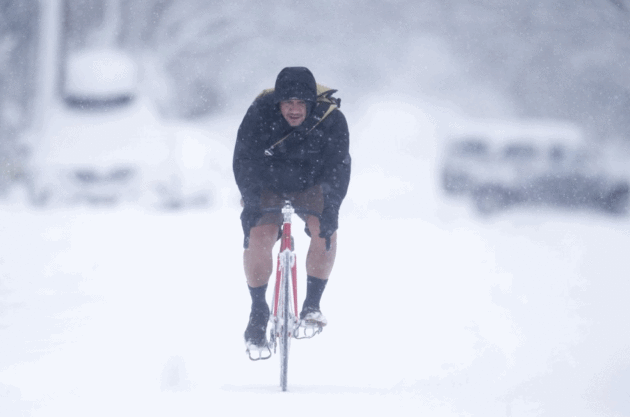
Photo credit: "
Mack
Faamausili of Northeast Portland headed into work on bike, only to
return home after learning it was closed for the day due to the winter
storm. In Northeast Portland, residents wandered through the streets and
in the snow in the early morning hours. Several inches of snow
blanketed Portland, January 11, 2017." Beth Nakamura/Staff.
Climate Change is Fueling a Second Chance for Nuclear Power. PRI,
Public Radio International, has the story: "...
Now,
the idea of cooling a reactor with liquid sodium is being revived by a
generation of nuclear scientists and entrepreneurs who see climate
change as a bigger threat than nuclear power. The highest-profile liquid
sodium project is being developed by TerraPower, backed by Bill Gates
and his former Microsoft chief technology officer Nathan Myhrvold. “From
a technical perspective, we’ve solved every technical problem that’s
occurred,” Myhrvold says. “But I can’t tell you, 'Oh yes, we’ve already
been successful.' It’s going to be many more years of hard work before
we are successful.” “So we made a crazy bet," he says, "and we’re going
to keep making that crazy bet..."
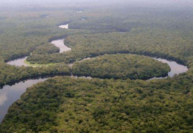
Carbon Deposit in Congo Swamp Equal to 20 Years of Gas Emissions: Study. Here's an excerpt from
Reuters: "
Scientists
say a recently discovered area of peatland straddling the two Congos
contains 30 billion tonnes of carbon dioxide, equivalent to 20 years of
U.S. greenhouse gas emissions, and must be protected to prevent major
environmental damage. The British
and Congolese teams, who made the discovery in 2014, say it is the
largest known tropical peatland - home to rare gorillas and forest
elephants - and in Wednesday's edition of Nature they say development
there would release the gas. Carbon
dioxide is linked to climate change and peatlands, formed from the
accumulation of dead plant material, act as "carbon sinks." Peat does
not decompose in a water-logged state but when it dries, the organisms
that break down plant material revive and the carbon seeps back into the
atmosphere..."
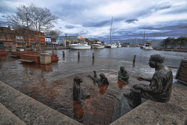
Guest Column: Climate Stewards' Views are Independent. Here's an excerpt of an Op-Ed at Maryland's Capital Gazette: "...Sea
level in Annapolis has risen by about a foot over the past 85 years and
is projected to rise at an increasing pace in the future. Current
efforts to protect our city from rising seas involve adaptation, but
even if the efforts succeed in holding back nuisance flooding and storm
surges for a decade or a century, adaptive measures do not address the
underlying problem: global warming is melting sheet ice and glaciers and
raising ocean temperatures, thus raising sea levels. Annapolis cannot
stop global warming, but as citizens and a city we can, while
implementing adaptive measures, set examples for how to shift away from
fossil fuels and advocate strongly, as people on the front line of
climate change, for effective mitigation policies at the state, national
and international levels..."
File photo:
Water Environment Federation.
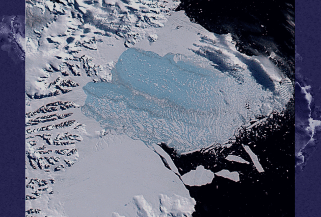
Antarctica Is About to Lose an Enormous Amount of Ice. The Question is What Happens After That. Chris Mooney has the story at
The Washington Post: "
Last week, British scientists announced a
disturbing finding — a crack in the Larsen C ice shelf in the Antarctic
Peninsula had dramatically accelerated its spread, increasing 11 miles
in length in the space of a month. This means the floating ice shelf,
which is nearly as big as Scotland and the fourth largest of its kind in Antarctica,
is poised to break off a piece nearly 2,000 square miles in size, or
over 10 percent of its total area. An ice island the size of a small
U.S. state would then be afloat in the Southern Ocean. That’s dramatic
enough, but there is uncertainty in the science world about what would
happen next. On the one hand, the researchers with Project MIDAS, who
announced the growth of the rift, have published research suggesting
that, in their words, it “presents a considerable risk to the stability
of the Larsen C Ice Shelf.” If they’re right, it’s hard to understate
how big a deal it is — Antarctica has lost ice shelves before, but not
one so enormous. Not only would a loss of Larsen C change the map of the
Earth itself; the shelf holds back glaciers capable of contributing
about 4 inches of global sea level rise over time..."
Image credit: "The Larsen B ice shelf on March 7, 2002, after it shattered into thousands of smaller icebergs." (NASA/Goddard Space Flight Center Scientific Visualization Studio.)
Alaskan Village, Citing Climate Change, Seeks Disaster Relief In Order to Relocate. There will be more climate refugees. Here's an excerpt from
NPR: "
The
tiny village of Newtok near Alaska's western coast has been sliding
into the Ninglick River for years. As temperatures increase — faster
there than in the rest of the U.S. — the frozen permafrost underneath
Newtok is thawing. About 70 feet of land a year erode away, putting the
village's colorful buildings, some on stilts, ever closer to the water's
edge. Now, in an unprecedented test case, Newtok wants the federal
government to declare these mounting impacts of climate change an
official disaster. Villagers say it's their last shot at unlocking the
tens of millions of dollars needed to relocate the entire community..."
Photo credit: "
The
Ninglick River is eating away at the shoreline in Newtok, Alaska, shown
here in August 2016. Engineers estimate the village is losing 70 feet
of land per year.
" Eric Keto/Alaska's Energy Desk.
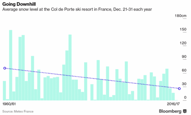
Swiss Alps Has Least Snowfall for Skiing in a Century. Bloomberg reports; here's a clip: "...You
can’t expect things to be the same as they are now in 50 years’ time,”
said Reto Knutti, a professor at the Swiss Federal Institute of
Technology’s Institute for Atmospheric and Climate Studies, who
estimates that by the end of this century the snowfall line could be 500
meters to 700 meters higher than today, with the length of time there’s
snow on the ground between four and eight weeks shorter. “Winter days
where at locations below 3,000 meters it just pours rain—that’ll be more
frequent.” Already, the snow season in Switzerland starts 12 days later
and ends 26 days earlier than in 1970, says Martine Rebetez, a
professor at the University of Neuchatel, who along with colleagues
studied data from 11 Alpine meteorological stations over four decades..."
Crazy Carbon Crystals and More New Ways to Fight Climate Change.
Are we on the cusp of a tech revolution in "carbon capture"? There are
some very encouraging developments, highlighted in a post at
Forbes; here are 2 excerpts: "...
In
other words the solution could be used to grab CO2, which contributes
to climate change, direct from the atmosphere and store it temporarily
into crystals that form as a result...What might surprise readers most,
though, is that this is just one way researchers have come up with to
extract greenhouse gases from the ambient air. Last year I reported on a novel method that uses solar power to transform ambient CO2
into a raw material that can be used to create all sorts of things from
aircraft to wind turbines. There's also interesting work going on
around injecting CO2 into rock and converting it into ethanol..."
Photo credit: "
Carbon dioxide trapped in crystals."
Republicans Want to Fight Climate Change, But Fossil Fuel Bullies Won't Let Them. Here's an excerpt of an Op-Ed from Senator Sheldon Whitehouse at
The Washington Post: "...
The
dirty secret is that climate change is not really a partisan issue in
Congress. Its history has not been partisan, with Republican senators
such as John McCain, Lamar Alexander, Susan Collins, Lindsey O. Graham
and Jeff Flake (as a House member) having introduced climate bills in
the past. Climate change became partisan in 2010, shortly after the five
Republican-appointed justices of the Supreme Court upended a century of
law and precedent to issue the Citizens United decision,
which rejected limits on corporate spending on political campaigns. The
timing is not a coincidence. Big-business interests, particularly the
fossil-fuel industry, led the charge. That industry’s annual U.S.
subsidy is $700 billion,
according to the International Monetary Fund. With stakes that high,
the incentive to protect the subsidy and the amount that the fossil-fuel
industry can afford to spend on political influence are enormous, so
the restraints of campaign finance and disclosure rules were
particularly galling..."
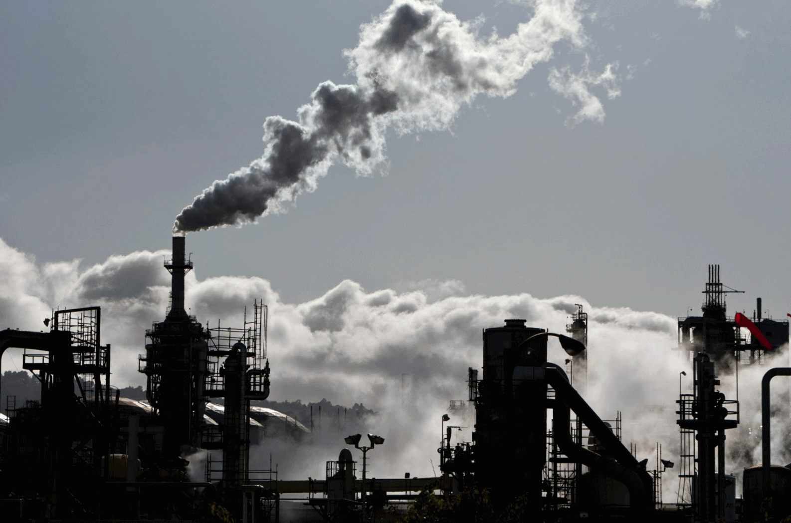
Photo credit: "
Smoke is released into the sky at a refinery in Wilmington, Calif." (Bret Hartman/Reuters).


No comments:
Post a Comment