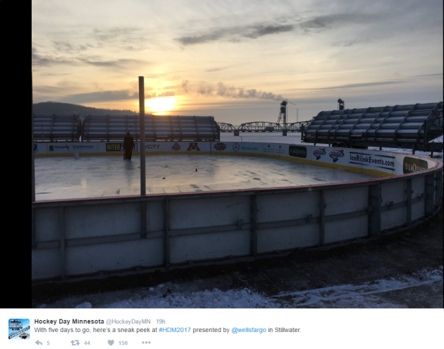
Hockey Day In Minnesota - Saturday, January 21st
One of my favorite days of the year is coming up this weekend! Weather conditions for Hockey Day in Minnesota over the years have ranged from brutally cold with frigid wind chills to picture perfect with light snow. This year's event will be held in Stillwater, located along the beautiful St. Criox River and while the setting couldn't be any more beautiful... unfortunately, the weather this Saturday looks a little ugly. High temperatures are expected to be in the low/mid 40s with a chance of a little light rain.
(Image below courtesy Twitter: @HockeyDayMN)
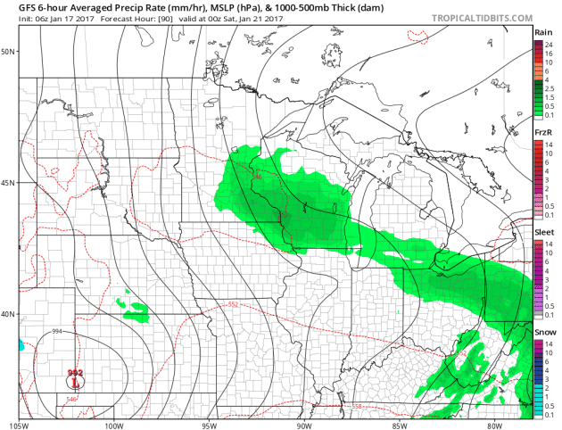
Saturday Weather Outlook
Here's the weather outlook from Friday night to PM Saturday, which shows scattered light rain showers rotating through the region. The storm system responsible for this somewhat soggy weather will also be responsible for temperatures in the low/mid 40s, which will be nearly 20F above average for mid/late January.
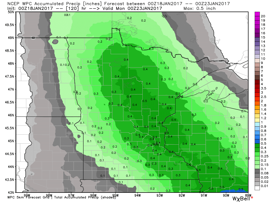
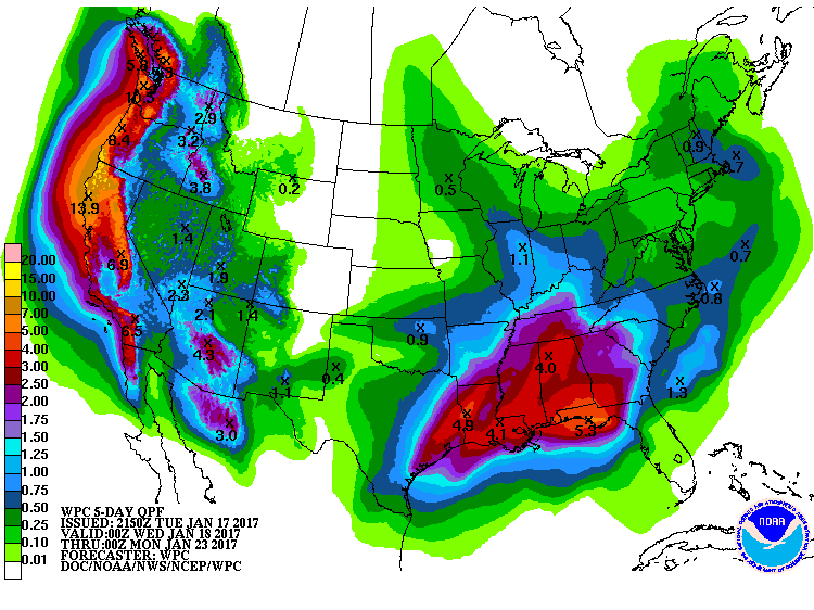
Precipitation Potential
Here's the precipitation potential through AM Sunday, which shows up to 0.4" liquid possible across parts of Minnesota and Wisconsin. Note that temperatures will be warm enough for mostly rain. Although rainfall tallies don't appear to be too terribly heavy, warm temperatures and rain will make any outdoor winter activities unfavorable. In the case for Saturday's Hockey Day in Minnesota, ice conditions will likely be warm, soft, slow and possibly even wet.
 ________________________________________________________________________
Early Spring-like Weather Maps. Lots of Drips
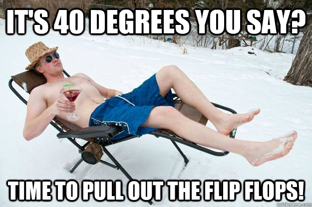
Have you heard that temperatures may hit 40 degrees or warmer over the next few days? No kidding!
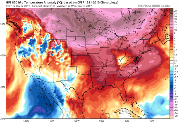
To outsiders, Minnesotan's look like a crazy bunch. Those who live here are well aware of how to deal with the cold, but bring on a 40 degree day in the middle of winter and yes, we probably are a little nuts. I wouldn't be surprised to see a few brave souls ditch the coat or even break out the flip flops as we enter a string of well above average temperatures. The increase in the temp department will come by way of several slaps of Pacific moisture along the West Coast.
Portland, OR wakes up to nearly 1/2 inch of crippling ice this morning while the extended forecast calls for widespread 6 to 12 inches of rain or more along the entire coast through next week. Some forecasts call for nearly 5 inches of drought denting rains in Los Angeles over the next 7 to 10 days!
Pieces of those western storms begin meandering into our neck of the woods later this week with light rain possible this weekend.
Enjoy the sun today! Where's the SPF?___________________________________________________________________________
Extended Forecast:
TUESDAY NIGHT: Mostly cloudy with patchy fog. Winds: SSW 5. Low: 18.
WEDNESDAY: Sunny and mild. Lots of drips. Winds: SSW 5. High: 40
WEDNESDAY NIGHT: Clouds thicken. Becoming mostly cloudy. Winds: SSW 5. Low: 29.
THURSDAY: Feels like March. Few afternoon sprinkles? Winds: SSE 4-8. High: 44
FRIDAY: Daytime showers. Light mix overnight. Winds: SE 5-10. Wake-up: 33. High: 42
SATURDAY: Mild with scattered light rain showers. Winds: E 5-10. Wake-up: 33. High: 44.
SUNDAY: Light rain mixes with a few wet flakes Winds: NW 5-10. Wake-up: 34. High: 41.
MONDAY: Mostly cloudy. Still warm for January. Winds: NW 5. Wake-up: 33. High: 40.
TUESDAY: Cooler. Light snow late. Winds: WSW 5. Wake-up: 28. High: 34.
_______________________________________________________________________________
_______________________________________________________________________________
This Day in Weather History
January 18th
January 18th
1996: A blizzard begins across the upper midwest. The Twin Cities Airport was spared the heavy snow, but received nearly one inch of rain. Heavy ice coating in the northwest metro area caused thousands of power outages. Wind chills were as low as -88 (on the old windchill scale) at Crookston. Snow totals were 18 inches at Ely and 12 inches at St. Cloud. Mail delivery was stopped for the day in Duluth and I-94 was closed all day from Rothsay and Moorhead. Flooding problems were caused in the Twin Cities due to backed up water.
1994: Governor Arne Carlson orders all Minnesota public schools closed due to the extreme cold and severe winter weather. Morning readings were in the 30-below-zero range. The biggest problem was from high winds that came with the cold.
_______________________________________________________________________________
_______________________________________________________________________________
Average High/Low for Minneapolis
January 18th
January 18th
Average High: 23F (Record: 48F set in 1891)
Average: Low: 7F (Record: -36F6set in 1887)
Average: Low: 7F (Record: -36F6set in 1887)
*Record Snowfall: 4.5" set in 2014
_______________________________________________________________________________
_______________________________________________________________________________
Sunrise Sunset Times For Minneapolis
January 18th
January 18th
Sunrise: 7:45am
Sunset: 5:02pm
Sunset: 5:02pm
*Daylight Gained Since Yesterday: ~1 minute 58 seconds
*Daylight Gained Since Winter Solstice (December 21st): ~31 minutes
________________________________________________________________________________
*Daylight Gained Since Winter Solstice (December 21st): ~31 minutes
________________________________________________________________________________
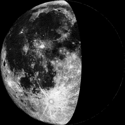
Moon Phase for January 16th at Midnight
1.6 Days Before Last Quarter
1.6 Days Before Last Quarter
__________________________________________________________________________________
Weather Outlook For Wednesday
High temperatures on Wednesday will be VERY mild across the region with highs approaching 40F in the Twin Cities. Note that this will be nearly 20F above average for the middle part of January. Interestingly, this is, on average, the coldest part of the year and it is going to feel more like March.
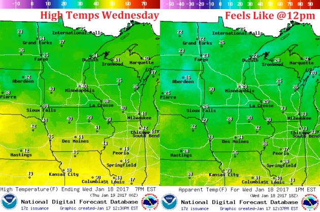
Weather Outlook For Wednesday
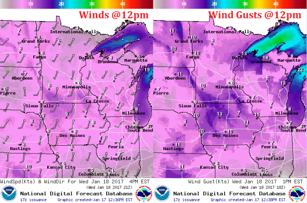
Winds will pick up out of the south on Wednesday, which will help to keep mild temperatures streaming into the Upper Midwest through the rest of the week. In fact, winds won't change much this week and temperatures will remain very mild through the weekend.
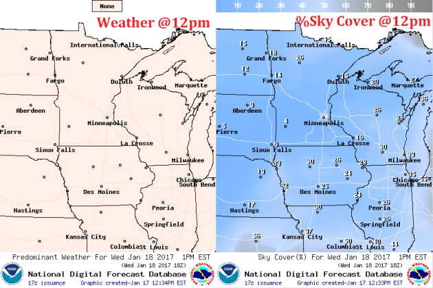
Mostly sunny to partly cloudy skies on Wednesday will make it feel like a spring day across the region. Enjoy it because clouds will be on the increase later this week with light chances into the weekend.
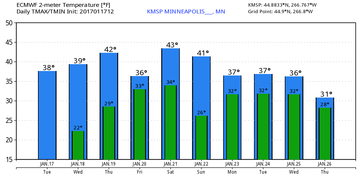
Extended Temperature Outlook for Minneapolis
Here's the temperature outlook through January 26th, which shows a VERY mild trend heading into the week ahead with highs in the 30s and even 40s this weekend! With several days above freezing, our snow pack will likely take a big hit... we may also have a fog concerns with melting snow and added moisture in the lower levels of the atmosphere.
___________________________________________________________________________________
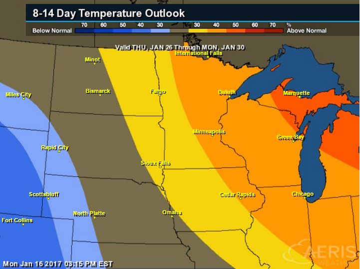
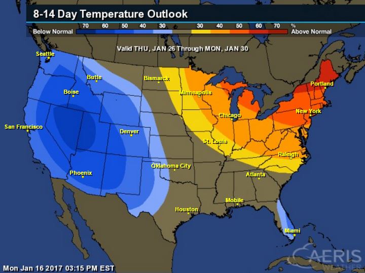
6 to 10 Day Temperature Outlook
According to NOAA's CPC, the 8 to 14 day temperature outlook suggests warmer than average temperatures continuing across much of the Upper Midwest from January 26th to January 30th. With that said, extended models are suggesting temperatures returning to near normal levels by the end of the month. Looking ahead, there doesn't appear to be any major cold snaps brewing over the next couple of weeks.
_________________________________________________________________________________
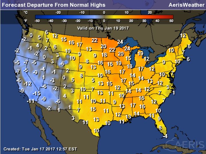
Highs From Average Thursday
Take a look at how much warmer than average much of the nation will be on Thursday. Just about everyone from the Front Range of the Rockies to the Eastern Seaboard will be at least 10F to near 20F above average!
National Temp Outlook
Take a look at the temperature anomaly through Wednesday, January 25th. Note that the Eastern half of the country looks to stay warmer than average through the entire time period. Late January appears to host colder than average weather across the western half of the country.
 Temperature Outlook
Take a look at the temperature anomaly through Wednesday, January 25th. Note that the Eastern half of the country looks to stay warmer than average through the entire time period. Late January appears to host colder than average weather across the western half of the country.
Here's the 8 to 14 day temperature outlook, which takes us into the end of January. Note that warmer than average temperatures continue across the Eastern U.S., while cold than average temperatures will move into the Western U.S.
 ________________________________________________________________________________
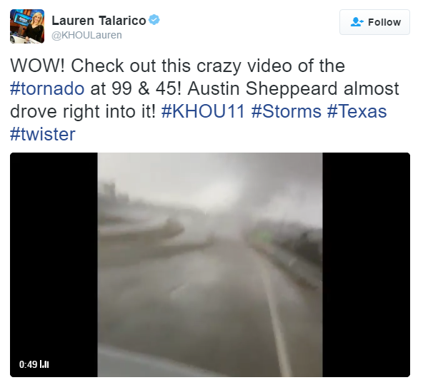
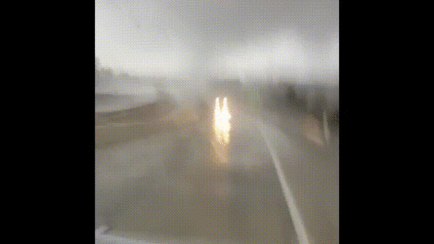
Tornado Near Houston, TX on Monday
Strong to severe storms, including tornadoes developed across parts of Texas on Sunday and Monday. One of those tornadoes was captured on video near Houston on Monday. Take a look at the tweet and video below. Note how close the person got to it before nearly running into it! YIKES!
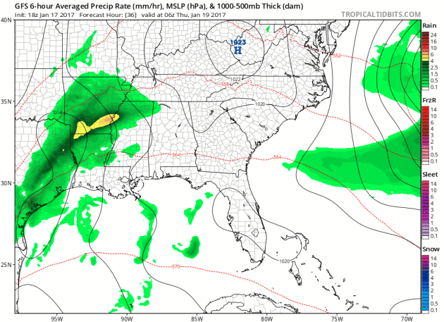
Thundery Outlook In the Southeast Through The Weekend
Heres' the simulated radar from Thursday to Sunday night, which shows ongoing showers and storms across parts of the Gulf Coast States. Note that an even more impressive storm develops over the weekend with more showers and storm across the Gulf Coast. This may be responsible for isolated severe storms and locally heavy rainfall.
National Weather Outlook
Here's the national weather outlook through the end of the week, which shows lingering showers and storms and locally heavy rainfall continuing and redeveloping across the Gulf Coast States. Some of the storms late week and into the weekend could be severe. Also note the next Pacific storm moving into the Western U.S. with widespread wintry weather and heavy rain along the coast.
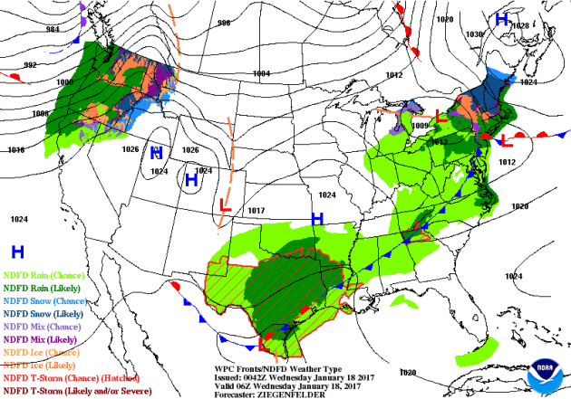
Winter weather headlines have been posted across parts of the Western U.S. in advance of another surge of Pacific moisture that will impact the region through midweek. This will create major issues with ice amounts possibly topping 0.5" to near 1" in some locations near the Columbia River Gorge. High elevations will see quite a bit of snow and lower elevations will see heavy rainfall potential.
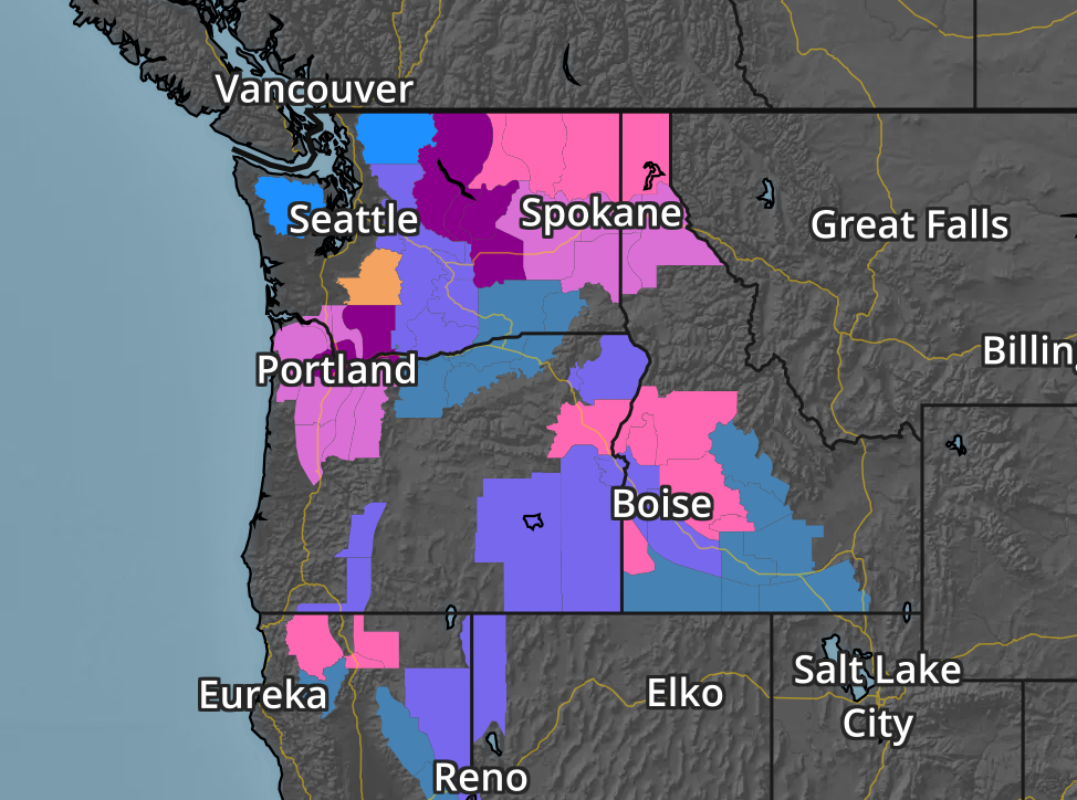
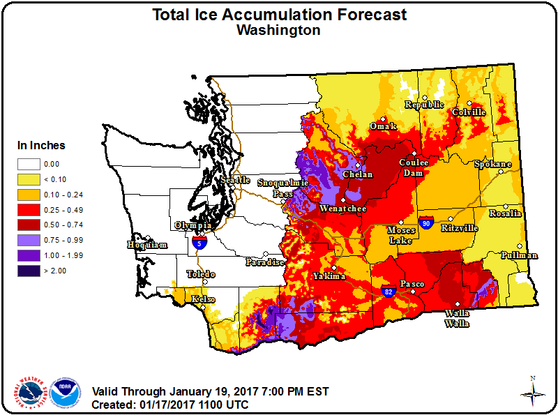
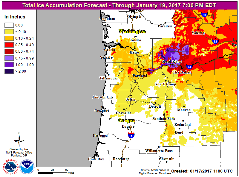
Ice Potential
Take a look at the icing potential from the state of Washington to near Portand, OR. Note that some locations sould see up to 0.5" to near 1" or more, which would create major issues in these areas. Significant travel issues and power outages will occur as this system gets underway later Tuesday through Wednesday.
According to NOAA's PC, the 5 day precipitation forecast suggests widespread 2" to 4"+ rainfall amounts across the Southern and Eastern U.S.. Also note the heavy moisture moving back into the West U.S., especially along the West Coast. Some 6" to 12"+ liquid tallies can't be ruled out from northern California to western Oregon and western Washington. There may even be some 3" to 6"+ tallies across parts of southern California through early next week.
Snowfall Potential
The extended forecast calls for additional heavy moisture in the Western U.S. with heavy snow in the high elevations. Note that widespread heavy snow looks to fall from the Cascades to the Sierra Nevada Range to parts of the Rockies. The additional heavy snow in the Sierra Nevada Range is wonderful news for the upcoming water supply during the summer months for parts of California.
_________________________________________________________________________________
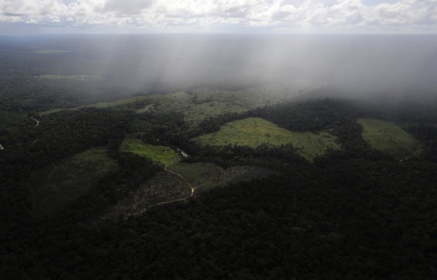
"Humans have destroyed 7% of Earth’s pristine forest landscapes just since 2000"
"Using satellite data, the researchers investigated changes to the world’s intact forest landscapes between 2000 and 2013. In 2000, they found that intact forest landscapes covered a total global area of 12.8 million square kilometers, or nearly 5 million square miles. But in the years since, human activities have altered and fragmented many of these areas. In total, truly intact forest landscapes declined by 7.2 percent. More than half these losses occurred in three countries alone: Russia, Brazil and Canada. In general, though, tropical parts of the world tended to suffer the greatest declines."
{A tract of Amazon rain forest, which has been cleared by loggers and farmers for agriculture, is seen near Santarem, Brazil, in April 2013. (Nacho Doce/Reuters)}
______________________________________________________________________________
"China, Europe drive shift to electric cars as U.S. lags"
"Electric cars will pick up critical momentum in 2017, many in the auto industry believe - just not in North America. Tighter emissions rules in China and Europe leave global carmakers and some consumers with little choice but to embrace plug-in vehicles, fuelling an investment surge, said industry executives gathered in Detroit this past week for the city's annual auto show."
{A 2018 Chevrolet Bolt EV is displayed during the North American International Auto Show in Detroit, Michigan, U.S., January 9, 2017. (REUTERS/Rebecca Cook/File Photo)}

"Japan’s Biggest Coral Reef Devastated by Bleaching"
Almost three-quarters of Japan’s biggest coral reef has died, according to a report that blames its demise on rising sea temperatures caused by global warming. The Japanese environment ministry said that 70 percent of the Sekisei lagoon in Okinawa had been killed by a phenomenon known as bleaching. Bleaching occurs when unusually warm water causes coral to expel the algae living in their tissues, causing the coral to turn completely white. Unless water temperatures quickly return to normal, the coral eventually dies from lack of nutrition. The plight of the reef, located in Japan’s southernmost reaches, has become “extremely serious” in recent years, according to the ministry, whose survey of 35 locations in the lagoon last November and December found that 70.1% percent of the coral had died.
(The white tips on this coral are a reflection of "bleaching" and declining coral health.
Credit: Oregon State University/flickr)
Credit: Oregon State University/flickr)

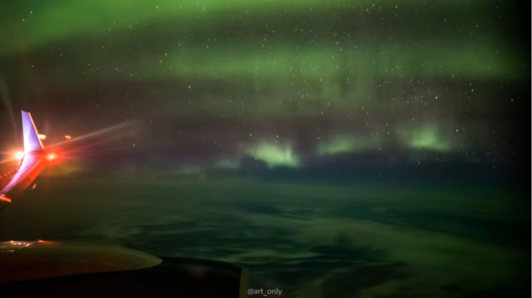
"Man Captures Northern Lights At 35,000 Feet After Finding Himself Sitting Alone On Flight"
With more and more of us flying on budget airlines, the idea of having space to spread out seems a little alien. Even extending your legs below the knee can prove troublesome. But now one man has shown the full potential of having a little more room to breathe, as he used an empty flight to set up his tripod and camera in the window seat and capture the Northern Lights.
_____________________________________________________________________________
Thanks for checking in and don't forget to follow me on Twitter @TNelsonWX

No comments:
Post a Comment