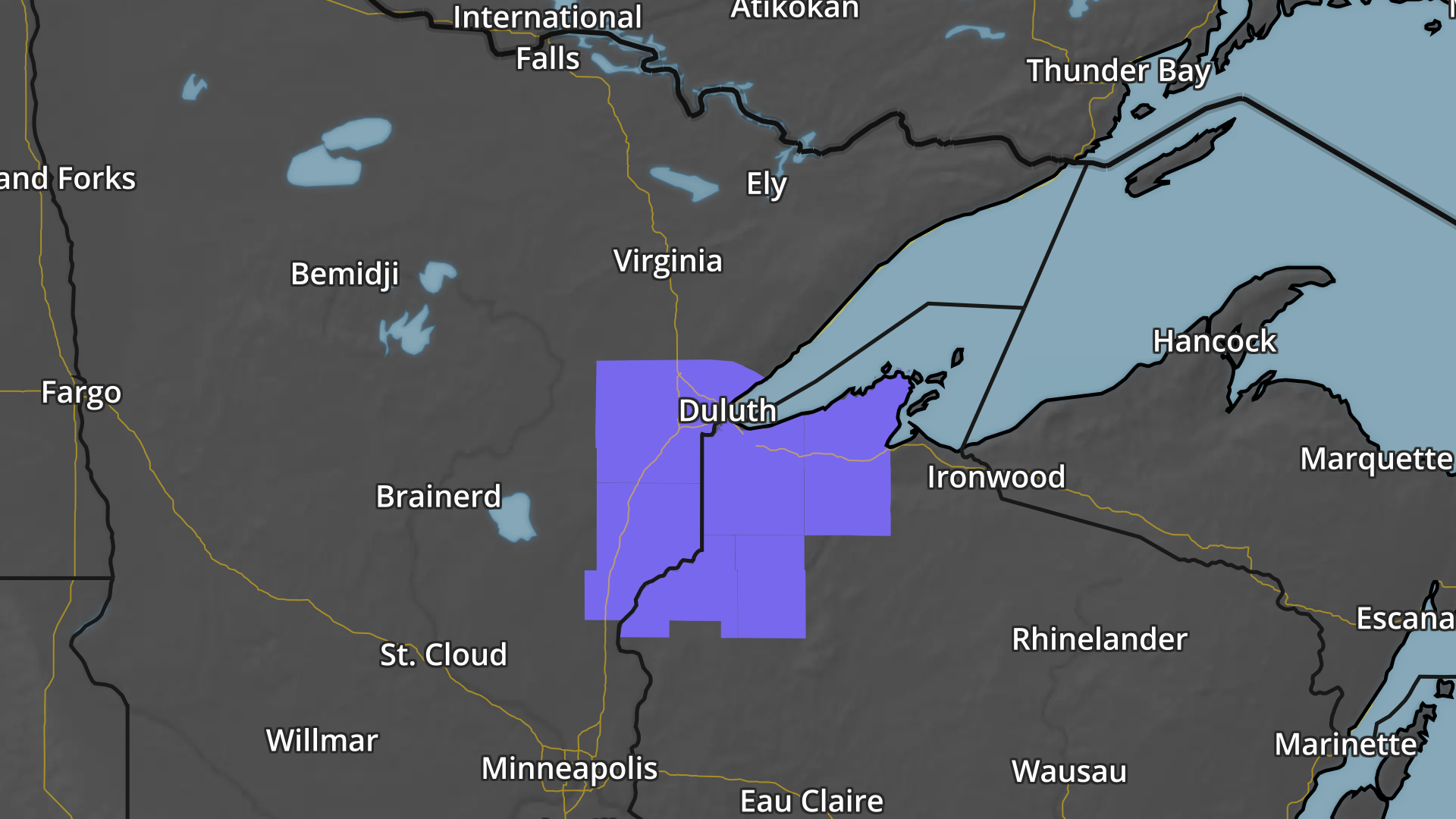
Winter Weather Advisory
A Winter Weather Advisory has been issued for parts of Minnesota and Wisconsin from 9AM to 7PM Monday for the potential of 3" to 5" of snow
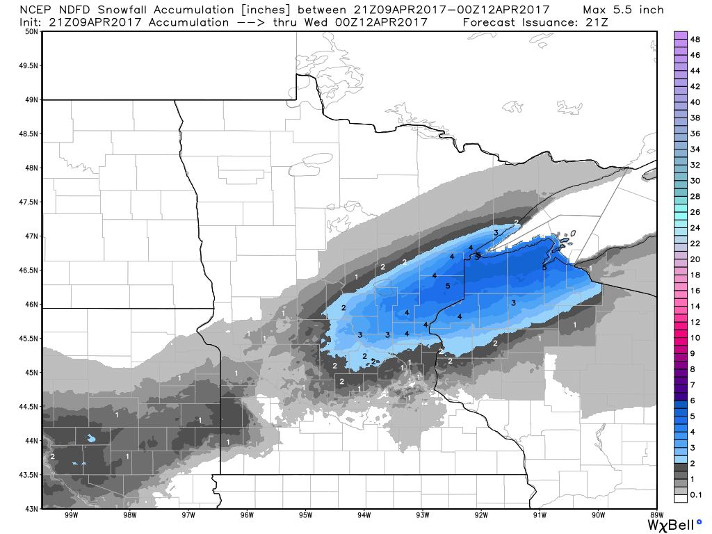
Snowfall Potential
Here's the snowfall potential through Tuesday, which suggests some 2" to near 4" tallies from north of the Twin Cities metro into Northwest Wisconsin. There could even be some 3" to 5" tallies for some locations close to Duluth.
Rain/Snow Mix Monday, Quieter By Tuesday
Here's the weather outlook from Sunday to Monday, which suggests a fairly unsettled and potentially thundery day across the Upper Midwest on Sunday. As the storm system moves through the region, isolated strong to severe storms maybe possible along with locally heavy rainfall on Sunday, while a rain/snow mix maybe possible on Monday and Tuesday as the storm system moves east.
.gif)
_______________________________________________________________________
"Dissecting climate trends in Minnesota month by month"
Mark Seeley is the Minnesota state climatologist and meteorologist at the University of Minnesota and recently wrote about how Minnesota's weather has changed over the last 100 years. He has come us with some interesting findings, especially when it comes to winter temperatures. Here's an excerpt from this week's Weather Talk:
"The biggest change has occurred in January with the monthly mean value now (most recent decade) that is 3.7°F higher than it was a century ago. This is a 57 percent increase relative to the 100 year mean monthly value for January temperature of 6.5°F (from a statewide calculation). By most statistical criteria this is a significant change in mean monthly temperature. Another example is the change in average February temperature. It is now 5.8°F greater than it was a century ago, and this represents 48 percent of the 100-year mean value for the month of 12.1°F. Some other months with significant changes in mean temperature are:
December: +3.0°F increase
March: +4.2°F increase
November: +2.9°F increase"
March: +4.2°F increase
November: +2.9°F increase"
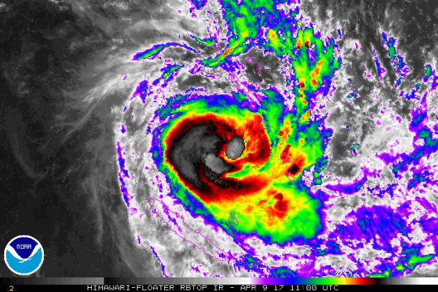
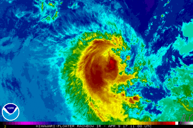
Tropical Cyclone COOK
Another cyclone has developed in the southern hemisphere and has been creating problems in the South Pacific. The cyclone created flooding in Vanuatu's central islands and is set to hit New Caledonia's main island. Interestingly, Cook will be the first cyclone to directly hit New Caledonia since 2003! Also, note that these storms are spinning anti-cyclonically because they are in the southern hemisphere!
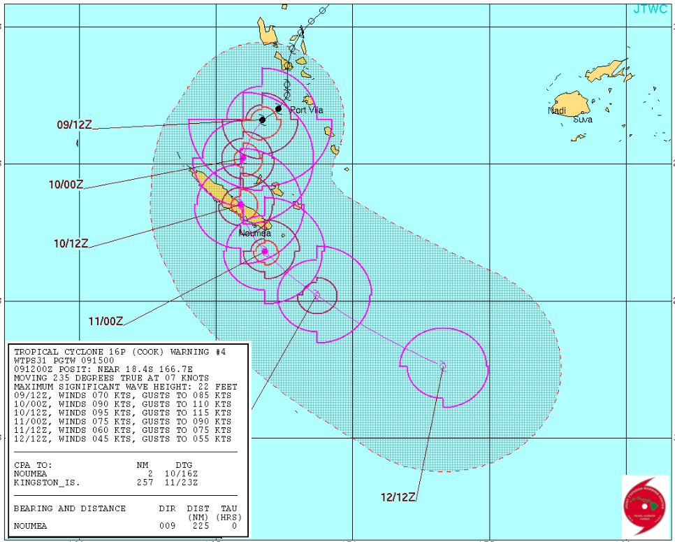
Tracking Cook
Here's the forecast for Cook over the next several days. The forecast track has it strengthening as it makes a direct hit with New Caledonia.
"New Caledonia bracing for Cyclone Cook"
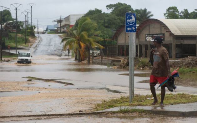
The cyclone caused flooding in Vanuatu's central islands yesterday and is now set to hit New Caledonia's main island with winds gusting now up to 160 kilometres an hour. The storm's centre is forecast to pass to the west of the Loyalty Islands, before making landfall on the east coast of the main island Grand Terre. Cyclone Cook will be the first to directly hit New Caledonia since 2003. Meteo France said the threat was very serious, forecasting gusts of up 200 kilometres an hour.
(Flooding in Vanuatu's capital, Port Vila. Photo: Dan McGarry)
__________________________________________________________________
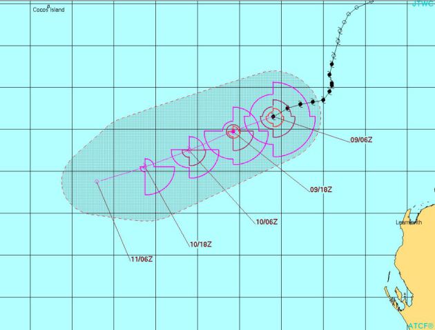
Tropical Cyclone ERNIE
Here's the latest from Ernie as it continues to weaken in the South Indian Ocean, just northwest of Australia. The good news is that this storm system did not impact Australia.
Tracking Ernie
Here's the forecast for Ernie from the Joint Typhoon Warning Center as it weakens and drifts south-southwest away from Australia over the next few days.
__________________________________________________________________________
2017 hurricane outlook: Colorado State predicts a slightly-below average season
Here we are at the beginning of April and we're already starting to think about the 2017 hurricane season. With the official start of the Atlantic hurricane season not starting until June 1st, Colorado State is already predicting a slightly below average season. By the way, the 2016 Atlantic Hurricane season was the first above average season since 2012! It produced 15 named storms, 7 of which were hurricane and 4 of those were major hurricanes (category 3 or higher). Here's an excerpt from Colorado State University: Colorado State University hurricane researchers are predicting a slightly below-average Atlantic hurricane season in 2017, citing the potential development of El Niño as well as recent anomalous cooling in the tropical Atlantic as primary factors. A weak La Niña this past winter has dissipated, and there is the potential that a weak to moderate El Niño could develop by the peak of the Atlantic hurricane season. El Niño tends to increase upper-level westerly winds across the Caribbean into the tropical Atlantic, tearing apart hurricanes as they try to form. In addition, most of the North Atlantic has anomalously cooled over the past month, and the tropical Atlantic is now slightly cooler than normal. In addition to providing less fuel for tropical cyclone formation and intensification, cooler tropical Atlantic sea surface temperatures are associated with a more stable atmosphere as well as drier air, both of which suppress organized thunderstorm activity necessary for hurricane development.
Named Storms (12)* 11
Named Storm Days (60.1) 50
Hurricanes (6.5) 4
Hurricane Days (21.3) 16
Major Hurricanes (2.0) 2
Major Hurricane Days (3.9) 4
Accumulated Cyclone Energy (92) 75
Net Tropical Cyclone Activity (103%) 85
* Numbers in ( ) represent medians based on 1981-2010 data.
Named Storm Days (60.1) 50
Hurricanes (6.5) 4
Hurricane Days (21.3) 16
Major Hurricanes (2.0) 2
Major Hurricane Days (3.9) 4
Accumulated Cyclone Energy (92) 75
Net Tropical Cyclone Activity (103%) 85
* Numbers in ( ) represent medians based on 1981-2010 data.
 _______________________________________________________________________
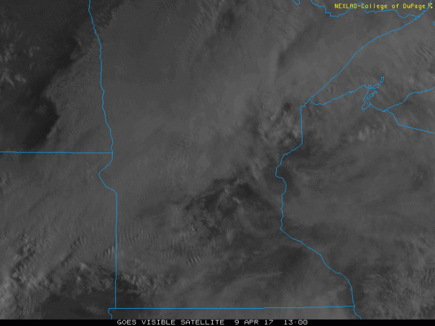
Visible Satellite on Sunday
Sunday was another somewhat cloudy day across the region as our storm system moved into place. A few locations started off with sunshine, but it quickly clouded over and widely scattered showers and storms developed across the southern half of the state.
 ___________________________________________________________________________

___________________________________________________________________________
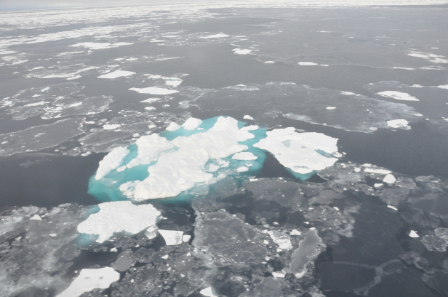
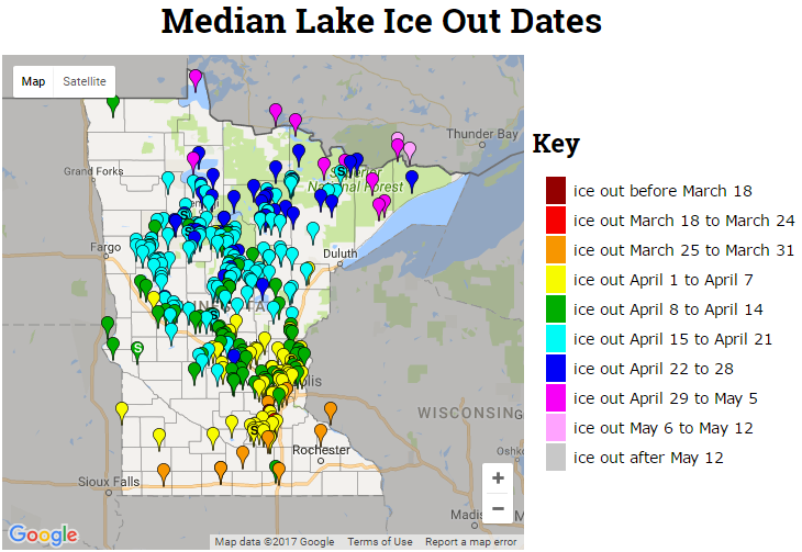
2017 Ice Out Dates
Here's the latest MN DNR ice out dates, which shows that more lakes across central and now northern MN have officially gone out for the season. Note that ice outs are occurring nearly 1 to 2 weeks ahead of schedule this year!
___________________________________________________________________________
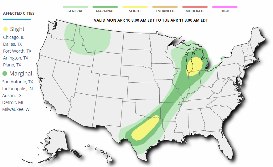
Active Early Week
Here's the weather outlook through AM Friday, which shows an ongoing thunder threat from the Great Lakes to the Southern Plains on Monday. A few of these storms could be a little on the strong to severe side with locally heavy rainfall. Meanwhile, more Pacific moisture will feed into the Western US with locally heavy rainfall and mountain snow.
Several Weather Threats Ahead
Weather conditions across the country look to remain somewhat active through the early week time frame, but not quite as active as it was over the past couple of weeks. According to NOAA's SPC, there is a risk of severe weather on Sunday and Monday across parts of the Central US. Large hail, damaging winds and isolated tornadoes maybe possible.
_________________________________________________________________________
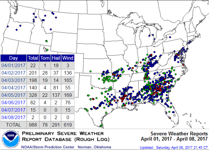
Active Start to April
According to NOAA's SPC, there have been nearly 1,000 severe weather reports through April 8th! While most of the reports have been either hail or wind reports, 78 of those have been tornadoes!
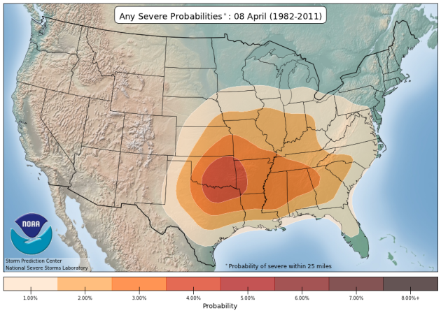
 Average Severe Weather For Early/Mid April
Here's an interesting map that shows the average severe weather probabilities for this time of the year and note that the highest concentration is across the Southern US and especially near the Arklatex region.
Average Severe Weather For Early/Mid April
Here's an interesting map that shows the average severe weather probabilities for this time of the year and note that the highest concentration is across the Southern US and especially near the Arklatex region.
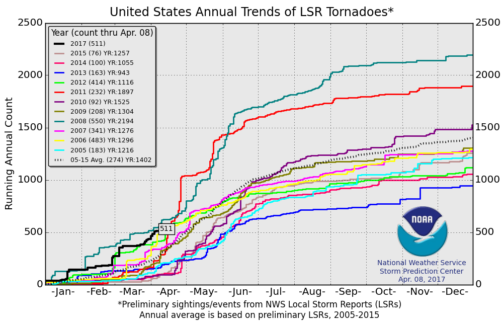
 2017 PRELIMINARY Tornado Count
According to NOAA's SPC, the PRELIMINARY tornado count for 2017 is at 511 (thru April 8). Interestingly, this is the highest number of tornado reports (thru April 8) since 2008 when 550 tornadoes were reported through that time frame. The 2005-2015 average number of tornado reports through April 8 is 274.
2017 PRELIMINARY Tornado Count
According to NOAA's SPC, the PRELIMINARY tornado count for 2017 is at 511 (thru April 8). Interestingly, this is the highest number of tornado reports (thru April 8) since 2008 when 550 tornadoes were reported through that time frame. The 2005-2015 average number of tornado reports through April 8 is 274.
 ________________________________________________________________
Wintry remnants today give way to 60s by Wednesday
By Todd Nelson, filling in for Douglas.I'm sure you've heard the "S" word being thrown around by now. Yes, the dirty little "S" word that we thought we wouldn't have to say anymore this year. Keep in mind that the Twin Cities still averages 2.4 inches of snow during the month of April, so we're not quite out of the woods yet.
Yesterday's thunderstorm activity gives way to a rain snow mix as the temperature drops through the day. I wouldn't doubt it if some north of the metro see a slushy coating by tonight. However, the best chance of a few inches of slop looks to fall across parts of Northwestern Wisconsin. The good news about snow this time of the year is that it doesn't stick around long. Though, on April 14th back in 1983, 13.6 inches of snow fell in one day. Good grief.
A few folks may get their undies in a bunch about Monday's snow chatter, but the extended outlook will help settle nerves. Sunshine returns Tuesday with high temperatures flirting with the 60s for the second half of the week. Spotty storms may develop late Friday, but should clear early this weekend.
______________________________________________________________________________
Extended Forecast:
Weather conditions across the country look to remain somewhat active through the early week time frame, but not quite as active as it was over the past couple of weeks. According to NOAA's SPC, there is a risk of severe weather on Sunday and Monday across parts of the Central US. Large hail, damaging winds and isolated tornadoes maybe possible.
_________________________________________________________________________
Active Start to April
According to NOAA's SPC, there have been nearly 1,000 severe weather reports through April 8th! While most of the reports have been either hail or wind reports, 78 of those have been tornadoes!
________________________________________________________________Wintry remnants today give way to 60s by Wednesday
By Todd Nelson, filling in for Douglas.I'm sure you've heard the "S" word being thrown around by now. Yes, the dirty little "S" word that we thought we wouldn't have to say anymore this year. Keep in mind that the Twin Cities still averages 2.4 inches of snow during the month of April, so we're not quite out of the woods yet.
Yesterday's thunderstorm activity gives way to a rain snow mix as the temperature drops through the day. I wouldn't doubt it if some north of the metro see a slushy coating by tonight. However, the best chance of a few inches of slop looks to fall across parts of Northwestern Wisconsin. The good news about snow this time of the year is that it doesn't stick around long. Though, on April 14th back in 1983, 13.6 inches of snow fell in one day. Good grief.
A few folks may get their undies in a bunch about Monday's snow chatter, but the extended outlook will help settle nerves. Sunshine returns Tuesday with high temperatures flirting with the 60s for the second half of the week. Spotty storms may develop late Friday, but should clear early this weekend.
______________________________________________________________________________
Extended Forecast:
MONDAY: Dropping temps. Rain/snow mix. Slushy coating north of the metro. Winds: NNW 10-15. High: 45, falling through the day.
MONDAY NIGHT: Cloudy with a chance of snow. Slushy coating possible. Winds: N 5-10. Low: 33.
TUESDAY: Sun returns. Feels warmer by afternoon. Winds: WNW 5. High: 54
WEDNESDAY: Clouds thicken, chance of rain late. Winds: S 5-10. Wake-up: 40. High: 62.
THURSDAY: Drying out. Clouds linger. Winds: SE 5-10. Wake-up: 44. High: 64.
FRIDAY: Gusty winds. Spotty PM showers. Winds: SSE 15-25. Wake-up: 44. High: 65.
SATURDAY: Leftover showers early, more PM sun. Winds: WNW 5-15. Wake-up: 49. High: 67.
SUNDAY: Looks dry, mild temperatures. Winds: NNW 5-10. Wake-up: 45. High: 62.
_______________________________________________________________________________
_______________________________________________________________________________
This Day in Weather History
April 10th
April 10th
1977: A record high of 86 is set at Redwood Falls.
_______________________________________________________________________________
_______________________________________________________________________________
Average High/Low for Minneapolis
April 10th
April 10th
Average High: 55F (Record: 88F set in 1977)
Average: Low: 35F (Record: 18F set in 1962)
Average: Low: 35F (Record: 18F set in 1962)
*Record Snowfall: 6.0" set in 1891
_______________________________________________________________________________
_______________________________________________________________________________
Sunrise Sunset Times For Minneapolis
April 10th
April 10th
Sunrise: 6:37am
Sunset: 7:52pm
Sunset: 7:52pm
*Daylight Gained Since Yesterday: ~3 minutes & 3 seconds
*Daylight Gained Since Winter Solstice (December 21st): ~4 hours & 31 minute
________________________________________________________________________________
*Daylight Gained Since Winter Solstice (December 21st): ~4 hours & 31 minute
________________________________________________________________________________
Moon Phase for April 9th at Midnight
1.0 Days until Full Pink Moon
1.0 Days until Full Pink Moon
Why is it the full pink moon? Here's an excerpt from Space.com: "April 11, 2:08 a.m. EDT – Full Pink Moon. The grass pink orchid, or wild ground phlox, is one of the earliest and most ubiquitous flowers of spring. Other names were the Full Sprouting Grass Moon, the Egg Moon and — among coastal tribes — the Full Fish Moon when the shad come upstream to spawn. In 2017, this is also the Paschal Full Moon; the first full moon of the spring season. The first Sunday following the Paschal Moon is Easter Sunday, which indeed will be observed five days later on Sunday, April 16."

________________________________________________________________________________
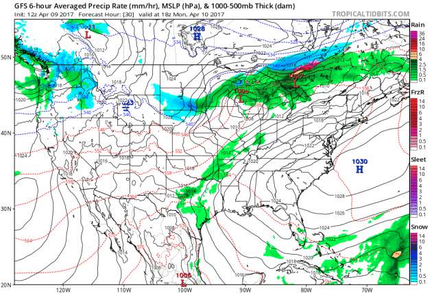
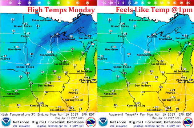
Weather Outlook For Monday
High temperatures on Monday will occur early in the day as the cold front sweeps through. It is likely that temperatures will slowly fall through the day, which will help to change any rain over the snow.
Weather Outlook For Monday
Winds will also be a bit breezy out of the north as the center of the storm pushes east of the region. Winds could actually gust to 20mph or greater across parts of the state.
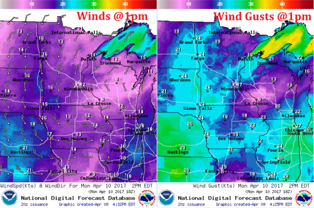
Here are the weather conditions around 1pm Monday. Note that a rain/snow mix will be possible across parts of central Minnesota into Northwest Wisconsin