
"Dissecting climate trends in Minnesota month by month"
Mark Seeley is the Minnesota state climatologist and meteorologist at the University of Minnesota and recently wrote about how Minnesota's weather has changed over the last 100 years. He has come us with some interesting findings, especially when it comes to winter temperatures. Here's an excerpt from this week's Weather Talk:
"The biggest change has occurred in January with the monthly mean value now (most recent decade) that is 3.7°F higher than it was a century ago. This is a 57 percent increase relative to the 100 year mean monthly value for January temperature of 6.5°F (from a statewide calculation). By most statistical criteria this is a significant change in mean monthly temperature. Another example is the change in average February temperature. It is now 5.8°F greater than it was a century ago, and this represents 48 percent of the 100-year mean value for the month of 12.1°F. Some other months with significant changes in mean temperature are:
December: +3.0°F increase
March: +4.2°F increase
November: +2.9°F increase"
March: +4.2°F increase
November: +2.9°F increase"

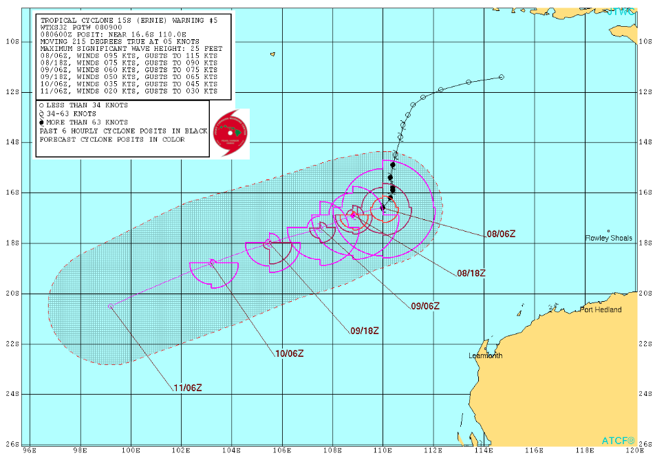
Tropical Cyclone ERNIE
While tropical activity close to home remains rather quiet, the Joint Typhoon Warning Center is keeping an eye on tropical activity near Australia in the Southern Indian Ocean The good news is that this storm is drifting south-southwest away from Australia and should pose no threat there.
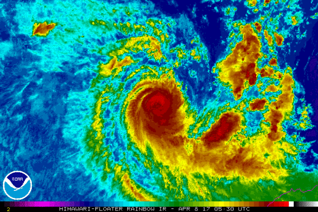
Tracking Ernie
Here's the forecast for Ernie from the Joint Typhoon Warning Center as it weakens and drifts south-southwest away from Australia over the next few days.
__________________________________________________________________________
2017 hurricane outlook: Colorado State predicts a slightly-below average season
Here we are at the beginning of April and we're already starting to think about the 2017 hurricane season. With the official start of the Atlantic hurricane season not starting until June 1st, Colorado State is already predicting a slightly below average season. By the way, the 2016 Atlantic Hurricane season was the first above average season since 2012! It produced 15 named storms, 7 of which were hurricane and 4 of those were major hurricanes (category 3 or higher). Here's an excerpt from Colorado State University: Colorado State University hurricane researchers are predicting a slightly below-average Atlantic hurricane season in 2017, citing the potential development of El Niño as well as recent anomalous cooling in the tropical Atlantic as primary factors. A weak La Niña this past winter has dissipated, and there is the potential that a weak to moderate El Niño could develop by the peak of the Atlantic hurricane season. El Niño tends to increase upper-level westerly winds across the Caribbean into the tropical Atlantic, tearing apart hurricanes as they try to form. In addition, most of the North Atlantic has anomalously cooled over the past month, and the tropical Atlantic is now slightly cooler than normal. In addition to providing less fuel for tropical cyclone formation and intensification, cooler tropical Atlantic sea surface temperatures are associated with a more stable atmosphere as well as drier air, both of which suppress organized thunderstorm activity necessary for hurricane development.
Named Storms (12)* 11
Named Storm Days (60.1) 50
Hurricanes (6.5) 4
Hurricane Days (21.3) 16
Major Hurricanes (2.0) 2
Major Hurricane Days (3.9) 4
Accumulated Cyclone Energy (92) 75
Net Tropical Cyclone Activity (103%) 85
* Numbers in ( ) represent medians based on 1981-2010 data.
Named Storm Days (60.1) 50
Hurricanes (6.5) 4
Hurricane Days (21.3) 16
Major Hurricanes (2.0) 2
Major Hurricane Days (3.9) 4
Accumulated Cyclone Energy (92) 75
Net Tropical Cyclone Activity (103%) 85
* Numbers in ( ) represent medians based on 1981-2010 data.
 _______________________________________________________________________
Visible Satellite on Saturday
Saturday's pesky high cloud cover was kind of a bummer. Don't get me wrong, it was nice and mild, but with the gusty winds and lack of bright blue skies, it wasn't as nice as I thought it would have been. Regardless, I hope you enjoyed the dry and mild weather because Sunday and Monday will be quite soggy as a storm system moves through the region.
 ___________________________________________________________________________

___________________________________________________________________________
If you're a gardener or a space guru this might be of some interest to you. Here's an excerpt from Earth to Sky Calculus regarding space seeds, which you can purchase if you're interested: "Northern Spring has arrived, and that means it's time to plant your garden. Your SPACE garden, that is. On March 26th, the students of Earth to Sky Calculus flew a payload-full of tomato and sunflower seeds to the edge of space. Carried 115,500 feet high by a giant helium balloon, the packets experienced temperatures as low as -63 C and cosmic ray dose rates 100 times Earth-normal. What will these far-out seeds yield? Find out for yourself! For only $39.95 we will send you a packet of space seeds along with control samples that remained on the ground during the flight. Plant them side by side for a backyard science experiment. Each shipment comes with a card telling the story of the flight and certifying that the seeds have been to the stratosphere and back again. Please specify your seed preference (Beefsteak tomato, cherry tomato, or sunflower) in the comments box at checkout."
See more from Earth to Sky Calculus HERE:

______________________________________________________________________________
Active Early Week
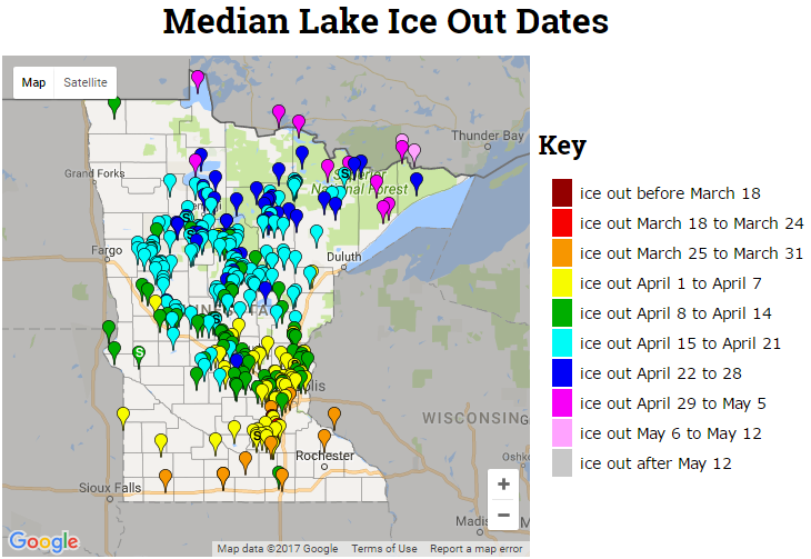
2017 Ice Out Dates
Here's the latest MN DNR ice out dates, which shows that more lakes across central and now northern MN have officially gone out for the season. Note that ice outs are occurring nearly 1 to 2 weeks ahead of schedule this year!
___________________________________________________________________________
Spring 2017 Continues to Arrive Early Across the Nation
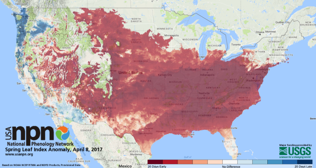
According to the National Phenology Network spring has sprung across much of the nation and arriving nearly 20 days earlier than a long-term average (1981-2010) in much of the South, Great Plains, Great Basin, mid-Atlantic, Midwest and parts of the Northeast. Here's the map as of April 8th, which now shows that parts of the High Plains, Upper Midwest and even parts of the Northeast are starting to see signs of spring!
See more from the USA NPN here:
_________________________________________________________________
See more from the USA NPN here:
_________________________________________________________________
Space Seeds?
See more from Earth to Sky Calculus HERE:
______________________________________________________________________________
Active Early Week
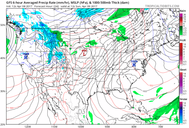
Here's the weather outlook through Thursday, which shows a fairly robust storm system moving through the Central US through the early week time frame. While strong to severe storms maybe possible Sunday and Monday, there also appears to be a little snow potential across the Upper Midwest and Great Lakes. The good news is that the weather doesn't appear to be as active as it was across the Southern US during the last week of March and the first week of April.
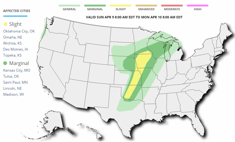
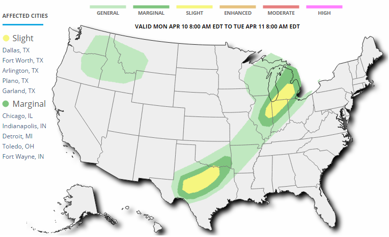
Several Weather Threats Ahead
Weather conditions across the country look to remain somewhat active through the early week time frame, but not quite as active as it was over the past couple of weeks. According to NOAA's SPC, there is a risk of severe weather on Sunday and Monday across parts of the Central US. Large hail, damaging winds and isolated tornadoes maybe possible.
_________________________________________________________________________
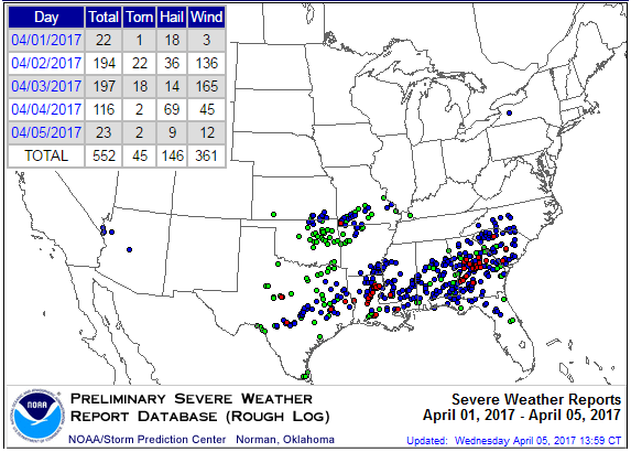
Active Start to April
According to NOAA's SPC, there have been nearly 550 severe weather reports through April 5th! While most of the reports have been either hail or wind reports, 45 of those have been tornadoes!
 Average Severe Weather For Early/Mid April
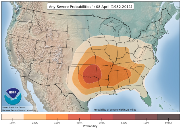
Here's an interesting map that shows the average severe weather probabilities for this time of the year and note that the highest concentration is across the Southern US and especially near the Arklatex region.
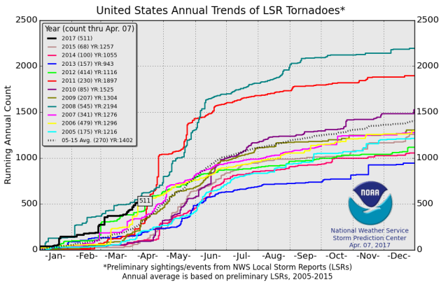
 2017 PRELIMINARY Tornado Count
According to NOAA's SPC, the PRELIMINARY tornado count for 2017 is at 511 (thru April 7). Interestingly, this is the highest number of tornado reports (thru April 7) since 2008 when 545 tornadoes were reported through that time frame. The 2005-2015 average number of tornado reports through April 7 is 270.
 ________________________________________________________________
Soggy Sunday ahead. A few strong storms south?
By Todd Nelson, filling in for Douglas."Can we fill up the kiddie pool?" I was asked eagerly by my 5 year old yesterday as he was running around the yard. "Not yet buddy, wait until it hits 80 degrees," I said. I guess have a promise to keep now, don't I?
70 degrees in April does something to a Minnesotans' psyche. It gets us all worked up. From long lines at city compost sites to frenzied activity at garden centers, many had a serious case of spring fever! It was the warmest day since early November, nearly 5 months ago!
A fairly robust storm system scoots through the Upper Midwest with scattered showers and storms, some of which could be strong to severe across parts of southern Minnesota later Sunday. Lingering rain showers mix with a few wet flakes late Monday as temperatures drop in the wake of the system. Parts of central Minnesota could end up with 1 to 2 inches of soaking rains, which will help alleviate some of the wildfire concerns until we green up.
After a brief cool down, temps look to rebound back into the 60s later this week. Spring has sprung!
______________________________________________________________________________
Extended Forecast:
Weather conditions across the country look to remain somewhat active through the early week time frame, but not quite as active as it was over the past couple of weeks. According to NOAA's SPC, there is a risk of severe weather on Sunday and Monday across parts of the Central US. Large hail, damaging winds and isolated tornadoes maybe possible.
_________________________________________________________________________
Active Start to April
According to NOAA's SPC, there have been nearly 550 severe weather reports through April 5th! While most of the reports have been either hail or wind reports, 45 of those have been tornadoes!
Here's an interesting map that shows the average severe weather probabilities for this time of the year and note that the highest concentration is across the Southern US and especially near the Arklatex region.
According to NOAA's SPC, the PRELIMINARY tornado count for 2017 is at 511 (thru April 7). Interestingly, this is the highest number of tornado reports (thru April 7) since 2008 when 545 tornadoes were reported through that time frame. The 2005-2015 average number of tornado reports through April 7 is 270.
Soggy Sunday ahead. A few strong storms south?
By Todd Nelson, filling in for Douglas."Can we fill up the kiddie pool?" I was asked eagerly by my 5 year old yesterday as he was running around the yard. "Not yet buddy, wait until it hits 80 degrees," I said. I guess have a promise to keep now, don't I?
70 degrees in April does something to a Minnesotans' psyche. It gets us all worked up. From long lines at city compost sites to frenzied activity at garden centers, many had a serious case of spring fever! It was the warmest day since early November, nearly 5 months ago!
A fairly robust storm system scoots through the Upper Midwest with scattered showers and storms, some of which could be strong to severe across parts of southern Minnesota later Sunday. Lingering rain showers mix with a few wet flakes late Monday as temperatures drop in the wake of the system. Parts of central Minnesota could end up with 1 to 2 inches of soaking rains, which will help alleviate some of the wildfire concerns until we green up.
After a brief cool down, temps look to rebound back into the 60s later this week. Spring has sprung!
______________________________________________________________________________
Extended Forecast:
SUNDAY: Mild with scattered storms, locally heavy rain. Winds: NE 5-15. High: 68
SUNDAY NIGHT: Showers and spotty thunderstorms, some with locally heavy rain. Low: 45
MONDAY: Dropping temps. Rain mixed with a few wet flakes. Winds: NNW 10-20. High: 46
TUESDAY: Hazy sun. Back to normal temps. Winds: NNW 5-10. Wake-up: 36. High: 54
WEDNESDAY: Few showers. 60s return. Winds: SW 5-10. Wake-up: 42. High: 61.
THURSDAY: Mostly sunny. Nicest day of the week. Winds: SE 5-15. Wake-up: 41. High: 61.
FRIDAY: Breezy. Scattered showers and storms. Winds: SE 15-25. Wake-up: 42. High: 64.
SATURDAY: Leftover showers, more PM sun. Winds: WSW 10-15. Wake-up: 45. High: 62.
_______________________________________________________________________________
_______________________________________________________________________________
This Day in Weather History
April 9th
April 9th
1931: Severe dust storms are reported in St. Paul.
_______________________________________________________________________________
_______________________________________________________________________________
Average High/Low for Minneapolis
April 9th
April 9th
Average High: 55F (Record: 81F set in 1930)
Average: Low: 34F (Record: 15F set in 1997)
Average: Low: 34F (Record: 15F set in 1997)
*Record Snowfall: 5.5" set in 1894
_______________________________________________________________________________
_______________________________________________________________________________
Sunrise Sunset Times For Minneapolis
April 9th
April 9th
Sunrise: 6:38am
Sunset: 7:51pm
Sunset: 7:51pm
*Daylight Gained Since Yesterday: ~3 minutes & 4 seconds
*Daylight Gained Since Winter Solstice (December 21st): ~4 hours & 28 minute
________________________________________________________________________________
*Daylight Gained Since Winter Solstice (December 21st): ~4 hours & 28 minute
________________________________________________________________________________
Moon Phase for April 8th at Midnight
2.0 Days until Full Pink Moon
2.0 Days until Full Pink Moon
Why is it the full pink moon? Here's an excerpt from Space.com: "April 11, 2:08 a.m. EDT – Full Pink Moon. The grass pink orchid, or wild ground phlox, is one of the earliest and most ubiquitous flowers of spring. Other names were the Full Sprouting Grass Moon, the Egg Moon and — among coastal tribes — the Full Fish Moon when the shad come upstream to spawn. In 2017, this is also the Paschal Full Moon; the first full moon of the spring season. The first Sunday following the Paschal Moon is Easter Sunday, which indeed will be observed five days later on Sunday, April 16."

________________________________________________________________________________
Weather Outlook For Sunday
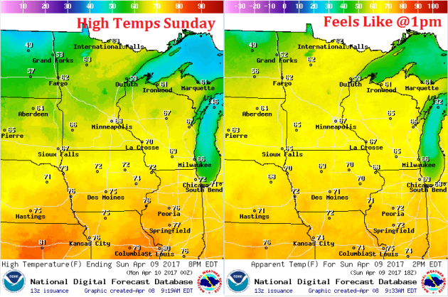
Despite being a soggy day, Sunday's high temperatures will be quite mild once again. Many across the state will be in the 60s prior to the cold front working through.
Weather Outlook For Sunday
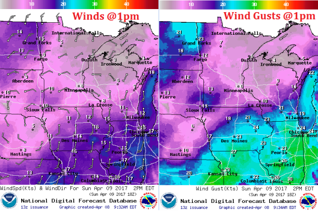
Saturday's wind gusts were very strong, at times gusting to near 30mph in a few locations. Thankfully the winds won't be quite as strong as our soggy storm system moves through on Sunday.
Here's the weather depiction for midday Sunday, which shows widespread shower and thunderstorm activity across the state. Keep in mind that some of the storms could be on the strong to severe side across the southern part of the state with locally heavy rainfall.