High Fire Danger
 We've
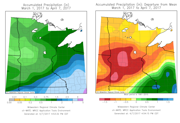
had a very recent dry period looking back over the past month here
across Minnesota. Many areas (with the exception of southeast Minnesota)
has received below average precipitation since March 1. Only 0.80" of
rain has fallen at the Twin Cities airport since that date, over one and
a half inches below average.
We've
had a very recent dry period looking back over the past month here
across Minnesota. Many areas (with the exception of southeast Minnesota)
has received below average precipitation since March 1. Only 0.80" of
rain has fallen at the Twin Cities airport since that date, over one and
a half inches below average.
 And
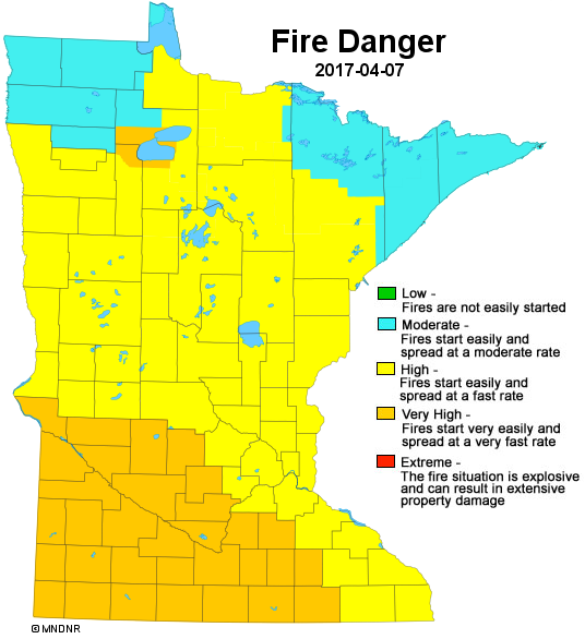
with little precipitation recently - as well as not that much snow in
some areas this past winter - the fire danger is quickly increasing
across the state. As of the Friday update from the Minnesota DNR, a good
portion of Minnesota was under either high or very high fire danger,
meaning that fires could start easily and spread at a fast rate.
And
with little precipitation recently - as well as not that much snow in
some areas this past winter - the fire danger is quickly increasing
across the state. As of the Friday update from the Minnesota DNR, a good
portion of Minnesota was under either high or very high fire danger,
meaning that fires could start easily and spread at a fast rate.
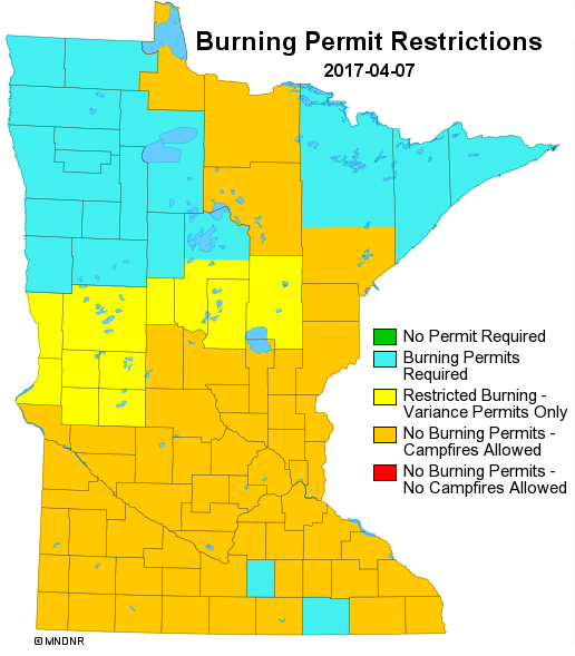 Due
to the high to very high fire danger, there are many areas of the state
where no burning permits are allowed besides campfires. The DNR
regularly updates this information on their website - you can check out
the latest by clicking here.
Due
to the high to very high fire danger, there are many areas of the state
where no burning permits are allowed besides campfires. The DNR
regularly updates this information on their website - you can check out
the latest by clicking here.
Meanwhile, it'll be very interesting to see if this still goes on Saturday: there is expected to be a wildfire training exercise at Camp Ripley, according to the Brainerd Dispatch. Read more about this exercise here.
_______________________________________________
Spectacular Saturday Ahead - First 70s Of The Year
By D.J. Kayser, filling in for Paul Douglas
It's been a nice start to spring so far, with fairly warm highs that make you shed those winter coats and bring out the shorts. One area that we are lacking in, though, is the moisture department. We've received only 0.80" of rain since March 1, over an inch and a half below average. This, on top of below average snow this winter, has led to a high fire danger across portions of the state.
While we will get to enjoy another warm weekend across the region, we will also add to our rain totals. As highs soar into the 70s and could even approach 80, today will be the best day of the weekend. Today will also be the first 70 degree day of 2017, which on average comes on April 9. How's that for timing?
A cold front dives south Saturday night before stalling across northern Iowa, bringing slightly cooler weather for Sunday along with up to an inch of rain across southern Minnesota. Behind that, periods of showers are likely through midweek with cooler temperatures. The good news: another warm up looks likely heading into next weekend.
_______________________________________________
Extended Forecast for Minneapolis
SATURDAY: A sunny, spectacular day. High 76. Low 52. Chance of precipitation 0%. Wind S 10-15 mph.
SUNDAY: Storm chances increasing. High 67. Low 46. Chance of precipitation 70%. Wind N 3-5 mph.
MONDAY: Cooler with more showers. High 55. Low 36. Chance of precipitation 60%. Wind NE 5-10 mph.
TUESDAY: Early snowflake? Partly sunny skies. High 53. Low 37. Chance of precipitation 10%. Wind NW 5-10 mph.
WEDNESDAY: Isolated shower, otherwise cloudy. High 60. Low 44. Chance of precipitation 20%. Wind SE 5-10 mph.
THURSDAY: AM showers. Slowly clearing skies. High 61. Low 40. Chance of precipitation 40%. Wind S 5-10 mph.
FRIDAY: Sunny with highs around average. High 59. Low 39. Chance of precipitation 5%. Wind SE 10-15 mph.
_______________________________________________
This Day in Weather History
April 8th
1805: John Sayer at the Snake River Fir Trading Post near present day Pine City mentions: 'The most tempestuous (stormy) day of the year. Pines and other trees fell near the fort.'
_______________________________________________
Average Temperatures & Precipitation for Minneapolis
April 8th
Average High: 54F (Record: 83F set in 1931)
Average Low: 34F (Record: 9F set in 1997)
Average Precipitation: 0.08" (Record: 0.73" set in 1906)
Average Snow: 0.1" (Record: 5.0" in 1980)
________________________________________________
Sunrise/Sunset Times for Minneapolis
April 8th
Sunrise: 6:40 AM
Sunset: 7:50 PM
*Length Of Day: 13 hours, 9 minutes and 41 seconds
*Daylight Added Since Yesterday: ~3 minutes and 4 seconds
*Next Sunrise At/Before 6 AM: May 2nd (6:00 AM)
*Next Sunset At/After 8 PM: April 16th (8:00 PM)
________________________________________________
Minnesota Weather Outlook
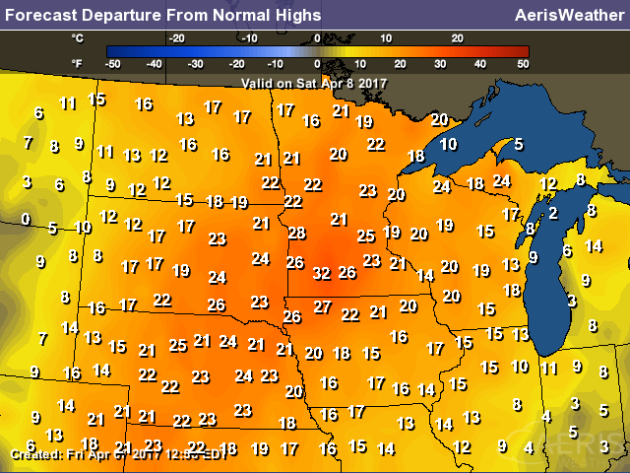
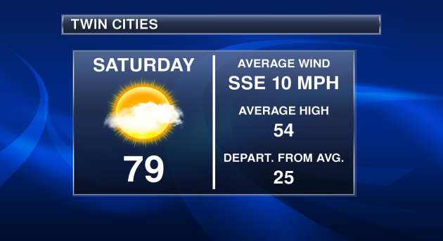 Today's
high in the Twin Cities will be a good 20-25 degrees above average for
this time of year, with south-southeast winds averaging around 10 mph.
Today's
high in the Twin Cities will be a good 20-25 degrees above average for
this time of year, with south-southeast winds averaging around 10 mph.
Extended Forecast for Minneapolis
SATURDAY: A sunny, spectacular day. High 76. Low 52. Chance of precipitation 0%. Wind S 10-15 mph.
SUNDAY: Storm chances increasing. High 67. Low 46. Chance of precipitation 70%. Wind N 3-5 mph.
MONDAY: Cooler with more showers. High 55. Low 36. Chance of precipitation 60%. Wind NE 5-10 mph.
TUESDAY: Early snowflake? Partly sunny skies. High 53. Low 37. Chance of precipitation 10%. Wind NW 5-10 mph.
WEDNESDAY: Isolated shower, otherwise cloudy. High 60. Low 44. Chance of precipitation 20%. Wind SE 5-10 mph.
THURSDAY: AM showers. Slowly clearing skies. High 61. Low 40. Chance of precipitation 40%. Wind S 5-10 mph.
FRIDAY: Sunny with highs around average. High 59. Low 39. Chance of precipitation 5%. Wind SE 10-15 mph.
_______________________________________________
This Day in Weather History
April 8th
1805: John Sayer at the Snake River Fir Trading Post near present day Pine City mentions: 'The most tempestuous (stormy) day of the year. Pines and other trees fell near the fort.'
_______________________________________________
Average Temperatures & Precipitation for Minneapolis
April 8th
Average High: 54F (Record: 83F set in 1931)
Average Low: 34F (Record: 9F set in 1997)
Average Precipitation: 0.08" (Record: 0.73" set in 1906)
Average Snow: 0.1" (Record: 5.0" in 1980)
________________________________________________
Sunrise/Sunset Times for Minneapolis
April 8th
Sunrise: 6:40 AM
Sunset: 7:50 PM
*Length Of Day: 13 hours, 9 minutes and 41 seconds
*Daylight Added Since Yesterday: ~3 minutes and 4 seconds
*Next Sunrise At/Before 6 AM: May 2nd (6:00 AM)
*Next Sunset At/After 8 PM: April 16th (8:00 PM)
________________________________________________
Minnesota Weather Outlook
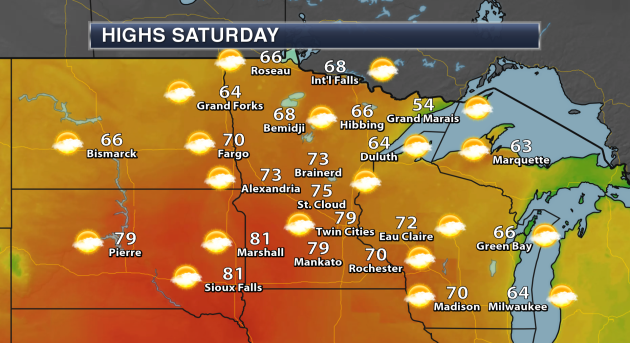
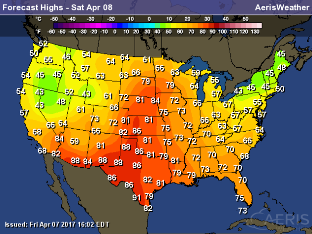
Get
out and enjoy the wonderful weather across the region today. Highs will
climb into the 70s and 80s across southern Minnesota, with highs in to
60s across the north. The cool spot will be along parts of Lake
Superior, where highs are only expected to be in the 50s in Grand
Marais.
With
highs in the 70s and 80s across portions of southern Minnesota, it's no
surprise that these temperatures will be a good 15-30°+ above average
for this time of year Saturday.
The
warm up doesn't last, though, as a cold front moves through Saturday
Night. By next week, temperatures will be back in the 50s and 60s for
highs, however there does appear to be another warm up in the forecast
heading into Easter weekend.
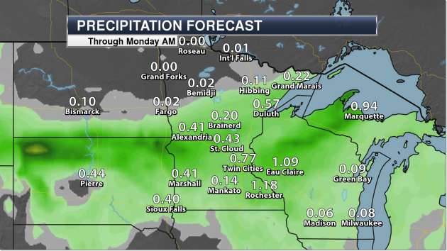 With
the next system that comes into the upper Midwest Sunday, we could see
some heavy rain across portions of southern Minnesota. Some spots of
southern Minnesota and western Wisconsin could pick up over an inch of
rain through Monday morning.
With
the next system that comes into the upper Midwest Sunday, we could see
some heavy rain across portions of southern Minnesota. Some spots of
southern Minnesota and western Wisconsin could pick up over an inch of
rain through Monday morning.
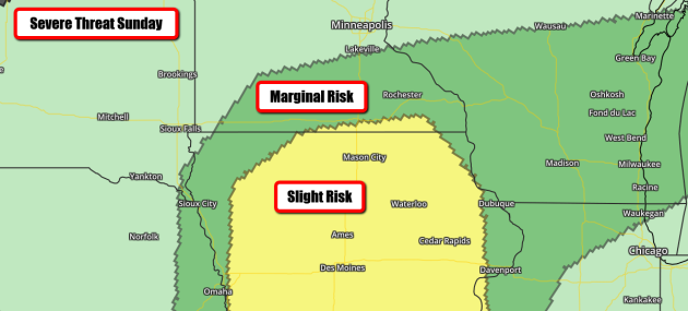 Some
of those storms over southern Minnesota could be strong Sunday
afternoon. There is a Marginal Risk of Severe Weather in place, with the
main threat being large hail.
Some
of those storms over southern Minnesota could be strong Sunday
afternoon. There is a Marginal Risk of Severe Weather in place, with the
main threat being large hail.
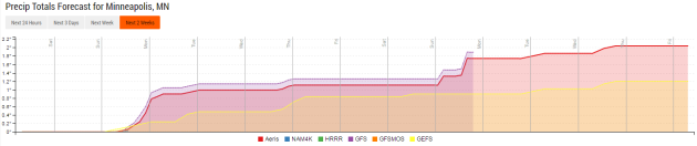 After
the rain Sunday, we'll watch a few more chances of showers through
midweek. It looks like we'll end next week dry, but more rain could be
possible for Easter Sunday.
After
the rain Sunday, we'll watch a few more chances of showers through
midweek. It looks like we'll end next week dry, but more rain could be
possible for Easter Sunday.
________________________________________________
National Weather Outlook
Warm Saturday In The Central U.S.
Feet of snow will be possible in the Sierra Nevada range through mainly Saturday, with only some lingering snow showers on Sunday. Some of that heavy snow will shift into parts of Idaho, Montana, and Wyoming late Saturday into Sunday, with over a half a foot likely in spots.
Five Day Precipitation Outlook
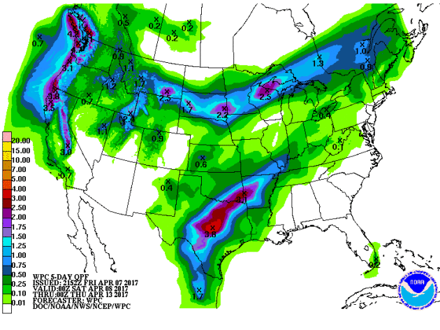
We'll be watching a few areas of heavy rain over the next five days. 3-5" will be possible in parts of the Pacific Northwest, especially along the coast, as a few systems impact the region from Friday Night through Wednesday. 2"+ of rain will be possible in the upper Midwest from late in the weekend to early next week. Another batch of heavy rain, from 2-4", will fall across Texas, Oklahoma and Arkansas early next week.
________________________________________________
Thursday's Tornadoes In The D.C. Area
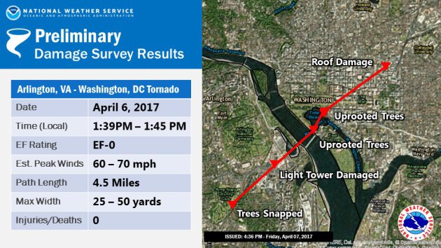 Image: NWS Baltimore-Washington D.C.At
least two tornadoes touched down in the Washington D.C. area Thursday
along a squall line called a QLCS. What is that? More from the Capital Weather Gang: "According
to one research study, these types of squall lines, called quasi-linear
convective systems (QLCS), generate 20 percent of all tornadoes in the
U.S. They are typically weaker, smaller and shorter-lived than the
classic supercell-type tornado, which is manufactured by a spiral or
“helical” updraft called a mesocyclone."
Image: NWS Baltimore-Washington D.C.At
least two tornadoes touched down in the Washington D.C. area Thursday
along a squall line called a QLCS. What is that? More from the Capital Weather Gang: "According
to one research study, these types of squall lines, called quasi-linear
convective systems (QLCS), generate 20 percent of all tornadoes in the
U.S. They are typically weaker, smaller and shorter-lived than the
classic supercell-type tornado, which is manufactured by a spiral or
“helical” updraft called a mesocyclone."
California Lifts The Drought Emergency
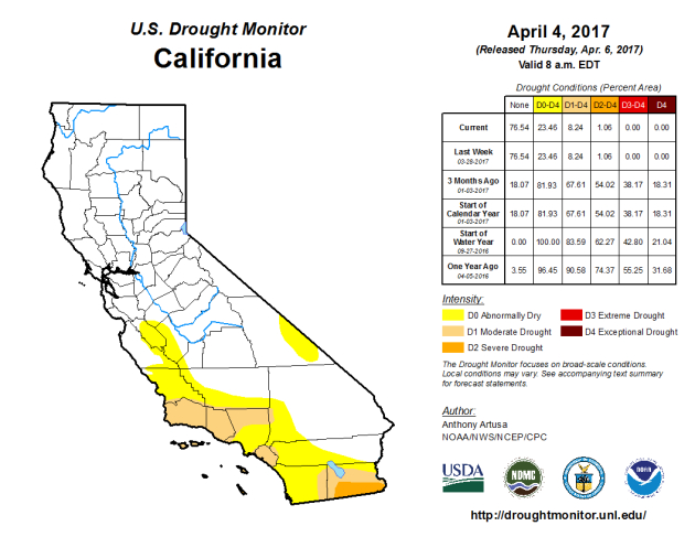
 Image: NOAATraveling
ships in the North Atlantic are on high alert for numerous icebergs in
the shipping lanes. How have they gotten there? Well, this is actually
years in the making. More from Popular Science: "There
is a swarm of about 481 icebergs parked in the shipping lanes of the
North Atlantic right now, creating a hazardous area so treacherous that
ships are having to detour 400 nautical miles out of their way to avoid
the Titanic’s infamous fate. The number of icebergs is unusual not only
because of the large number but also because of the speed at which the
icebergs gathered, and strange timing, early in the year."
Image: NOAATraveling
ships in the North Atlantic are on high alert for numerous icebergs in
the shipping lanes. How have they gotten there? Well, this is actually
years in the making. More from Popular Science: "There
is a swarm of about 481 icebergs parked in the shipping lanes of the
North Atlantic right now, creating a hazardous area so treacherous that
ships are having to detour 400 nautical miles out of their way to avoid
the Titanic’s infamous fate. The number of icebergs is unusual not only
because of the large number but also because of the speed at which the
icebergs gathered, and strange timing, early in the year."
Coal Mining Museum Powered By... Solar?
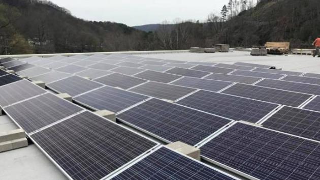 Image: WTMY-TVThat's right. The Kentucky Coal Mining Museum has installed solar panels and is now fueled by the sun. More from WYMT-TV: "The
Kentucky Coal Mining Museum in Benham is owned by Southeast Kentucky
Community and Technical College. Communications Director Brandon
Robinson told WYMT, they're hoping to save money by the switch. "
Image: WTMY-TVThat's right. The Kentucky Coal Mining Museum has installed solar panels and is now fueled by the sun. More from WYMT-TV: "The
Kentucky Coal Mining Museum in Benham is owned by Southeast Kentucky
Community and Technical College. Communications Director Brandon
Robinson told WYMT, they're hoping to save money by the switch. "
Warmth Out West In March
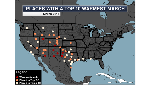
Unlike February, the warmth could be found in the western U.S. last month. More from the Praedicitx blog: "The heat shifted west for the most part during the month of March, with 60 long-term NWS climate locations from Washington state to the Gulf Coast seeing a top ten warmest March on record. A total of nine locations saw their warmest March on record, including Salt Lake City and Albuquerque."
________________________________________________
Thanks for checking in and have a great Saturday! Don't forget to follow me on Twitter (@dkayserwx) and like me on Facebook (Meteorologist D.J. Kayser)!
- D.J. Kayser

________________________________________________
National Weather Outlook
Warm Saturday In The Central U.S.
The
warmest weather during Saturday will be in the central U.S., where
highs will climb into the 70s and potentially 80s as far north as South
Dakota and Minnesota. It could be warmer in these areas than it will be
across Florida! For example, the forecast high in the Twin Cities is
76... in Orlando, FL it is 75! Areas like Goodland (KS), Grand Island
(NE) and even Marquette (MI) could see record high temperatures. On
either side of that ridge of warmth will be some cooler weather, as
parts of the Northeast and western U.S. won't make it out of the 50s for
highs.
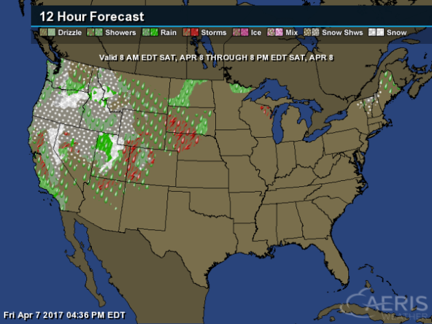
National Saturday Forecast
Most
of the weather on Saturday will occur out west, where rain and snow
will be possible. A few strong storms will be possible in the Salt Lake
City area. A few showers and storms will be possible across the Dakotas
and far northern Minnesota, meanwhile a few rain and snow showers will
be possible in northern New England. Other than that, no real inclement
weather is expected across the rest of the lower 48!
Snow Potential Through Sunday EveningFeet of snow will be possible in the Sierra Nevada range through mainly Saturday, with only some lingering snow showers on Sunday. Some of that heavy snow will shift into parts of Idaho, Montana, and Wyoming late Saturday into Sunday, with over a half a foot likely in spots.
We'll be watching a few areas of heavy rain over the next five days. 3-5" will be possible in parts of the Pacific Northwest, especially along the coast, as a few systems impact the region from Friday Night through Wednesday. 2"+ of rain will be possible in the upper Midwest from late in the weekend to early next week. Another batch of heavy rain, from 2-4", will fall across Texas, Oklahoma and Arkansas early next week.
Thursday's Tornadoes In The D.C. Area
California Lifts The Drought Emergency
With heavy rain during January and February across the state of California, Governor Brown
of California lifted the drought emergency today for all but four
counties. As of the latest Drought Monitor (released on Thursday), only 1% of California remains in Severe Drought, with 8% of the state in Moderate Drought. More from Cal OES: "Following
unprecedented water conservation and plentiful winter rain and snow,
Governor Edmund G. Brown Jr. today ended the drought state of emergency
in most of California, while maintaining water reporting requirements
and prohibitions on wasteful practices, such as watering during or right
after rainfall. “This drought emergency is
over, but the next drought could be around the corner,” said Governor
Brown. “Conservation must remain a way of life.”"
Icebergs And Ships... I Don't Think They Mix NicelyCoal Mining Museum Powered By... Solar?
Warmth Out West In March
Unlike February, the warmth could be found in the western U.S. last month. More from the Praedicitx blog: "The heat shifted west for the most part during the month of March, with 60 long-term NWS climate locations from Washington state to the Gulf Coast seeing a top ten warmest March on record. A total of nine locations saw their warmest March on record, including Salt Lake City and Albuquerque."
________________________________________________
Thanks for checking in and have a great Saturday! Don't forget to follow me on Twitter (@dkayserwx) and like me on Facebook (Meteorologist D.J. Kayser)!
- D.J. Kayser
No comments:
Post a Comment