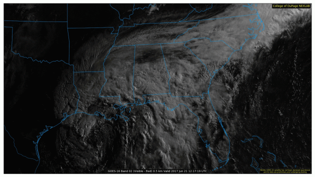
Tropical Storm Cindy in the Gulf of Mexico
Take a look at the new GOES 16 visible satellite loop of Tropical Storm Cindy from early Wednesday. Although Cindy didn't/doesn't look all that impressive from the satellite prospective, heavy rain is really the most concerning part of this system. With as much as 10" to 15" of total rainfall possibly falling in some locations across the Gulf Coast States, this could create life-threatening flooding in some locations. Note that we're not even a full month into the 2017 Atlantic Hurricane season and we've already had 3 named storms develop in the basin.
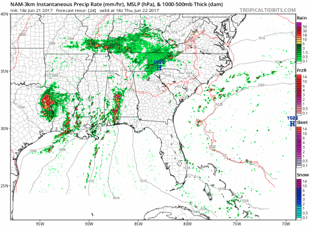
Tropical Trouble in the Gulf of Mexico
Here's the forecast as Cindy moves inland through the end of the week. Note that the system looks a little more organized on Thursday, but as it moves through the Ohio and Tennessee Valley it will quickly fall apart. Regardless of its strength, heavy rainfall will still be possible over the next few days.
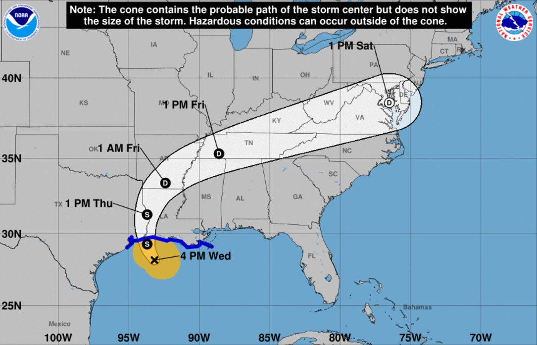
Tracking Tropical Storm Cindy
According to NOAA's NHC, the track of this storm will likely make landfall somewhere along the Texas/Louisiana coastline late Wednesday night/early Thursday morning as Tropical Storm Cindy. Tropical Storm Force winds could create high seas and minor wind damage as it nears the coast, but heavy rainfall and flooding is still expected to be the major concern over the next few days.
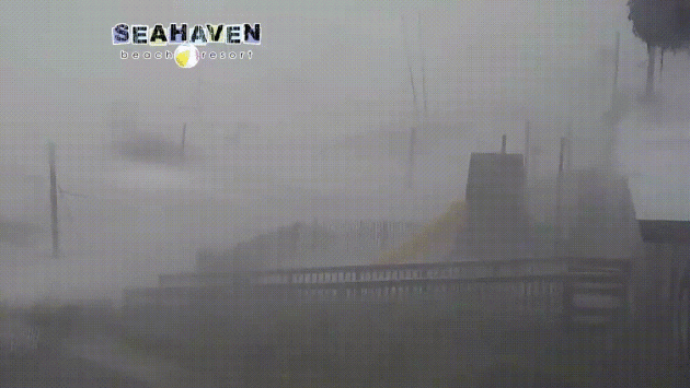
Panama City Beach, FL
Take a look what Panama City Beach, FL looked like on Wednesday as bands of heavy rain moved through the region. At this time, Bay county was under a flash flood warning, which included Panama City Beach, FL where 2" to 3" of rain had already fallen and another 1" to 2" was expected to fall through the morning.
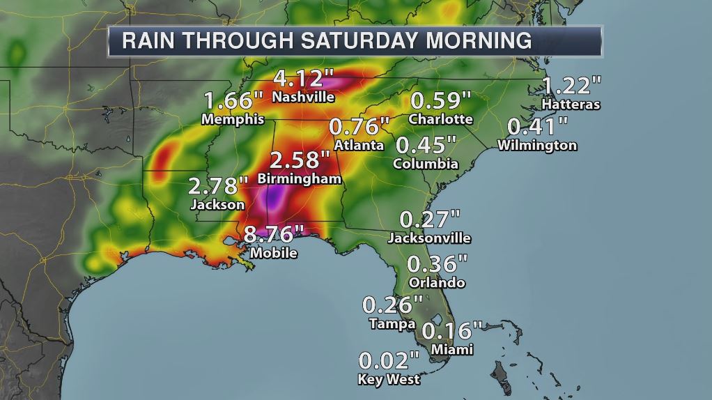
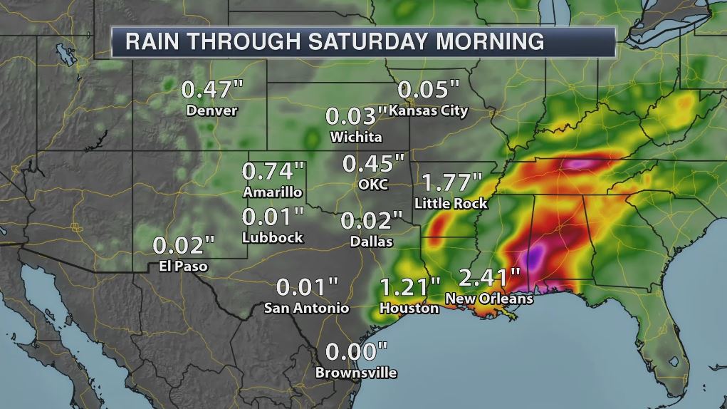
Heavy Rain Reports
Here's a quick look at how much rain has fallen across parts of the Panhandle of Florida since Tropical Storm Cindy moved into the region. Note that many locations have already seen more than 2" with more than 7" already falling in at the Pensacola Airport.
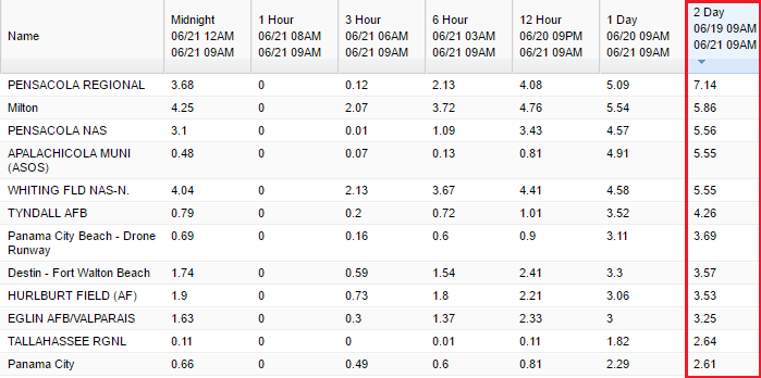
Flash Flood Watches Continue
The National Weather Service continues Flash Flood Watches across a wide from eastern Texas to Georgia, where heavy rainfall could lead to additional flash flooding through the end of the week. With many spots already seeing significant rainfall and more significant rainfall on the way, flash flooding will be the most serious part of this entire system.
Here's a quick look at how much rain has fallen across parts of the Panhandle of Florida since Tropical Storm Cindy moved into the region. Note that many locations have already seen more than 2" with more than 7" already falling in at the Pensacola Airport.
Flash Flood Watches Continue
The National Weather Service continues Flash Flood Watches across a wide from eastern Texas to Georgia, where heavy rainfall could lead to additional flash flooding through the end of the week. With many spots already seeing significant rainfall and more significant rainfall on the way, flash flooding will be the most serious part of this entire system.
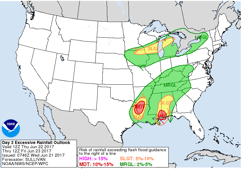
Flood Concerns Thursday & Friday
According to NOAA, excessive rainfall will be possible through the end of the week across the Southern US. In fact, there are moderate chances of excessive rainfall on Thursday across the Gulf Coast States where significant rainfall is possible, which a slight risk of excessive rainfall has been issued across parts of the Ohio and Tennessee Valley.
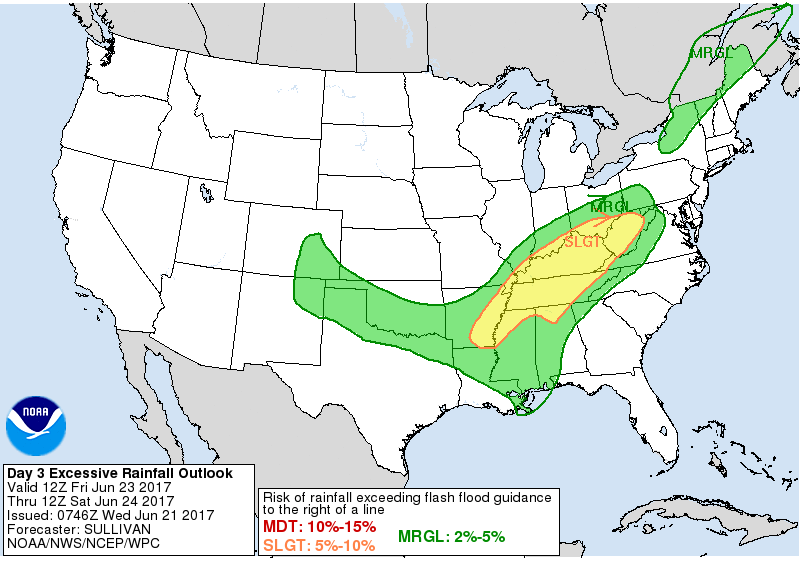
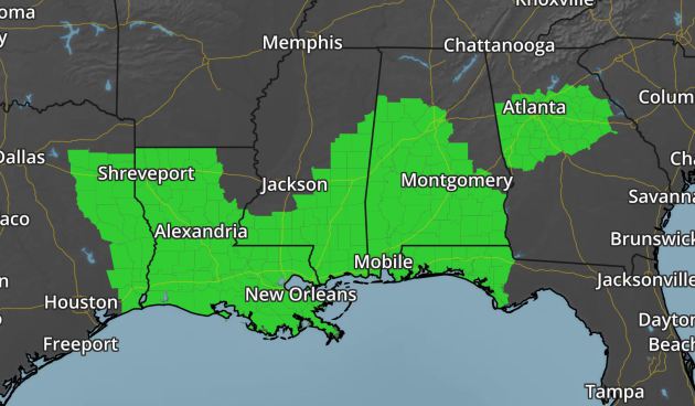
Heavy Rain Concerns
Flash Flood Watches have been posted by the National Weather Service across a wide area from Louisiana to Florida and Georgia. As deep tropical moisture soaks the region, widespread flooding can't be ruled out. Some of the latest forecast suggest that more than 10" of rain may be possible in spots through the weekend!
 ________________________________________________________
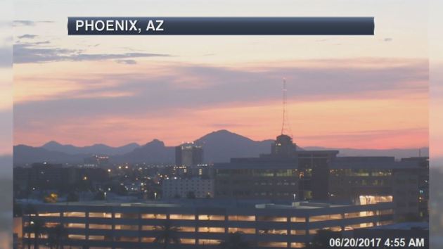
"It’s so hot in Phoenix that airplanes can’t fly"
"There are certain truths that accompany summer in Phoenix: Triple-digit temperatures persist well past sundown. It’s not considered abnormal to drive with oven mitts or ice packs in the car. And after a certain threshold, even the “it’s a dry heat” jokes cease being funny. Usually, the hot season is met with a certain amount of pearl-clutching disbelief by people outside of Arizona. Meanwhile, locals shrug, knowing simply to stay indoors as much as possible or escape to the cooler climes of Northern Arizona. But this week has felt different, even for seasoned desert-dwellers. As the Capital Weather Gang reported, the Southwest is experiencing its worst heat wave in decades. Excessive heat warnings have been in effect from Arizona to California and will be for the remainder of the week. How hot has it been? On Monday, temperatures in Phoenix hit 118 degrees, according to the National Weather Service, which announced the record-tying heat against a stock image of a flaming ball of fire."
(With temperatures likely to reach triple digits in Phoenix, American Airlines on June 20 cancelled dozens of inbound and outbound flights.(Reuters))

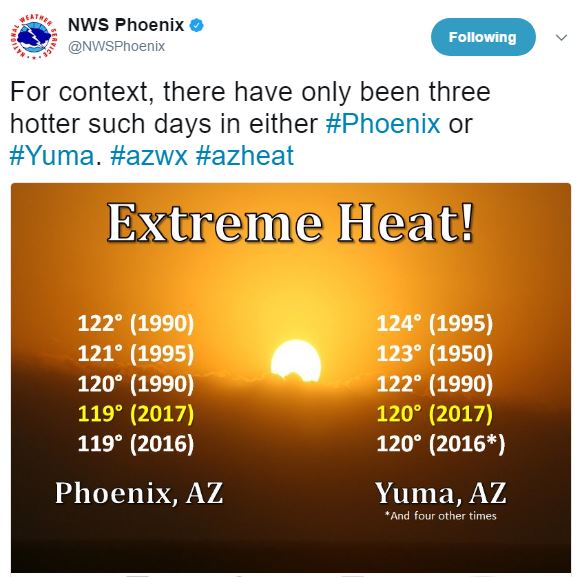
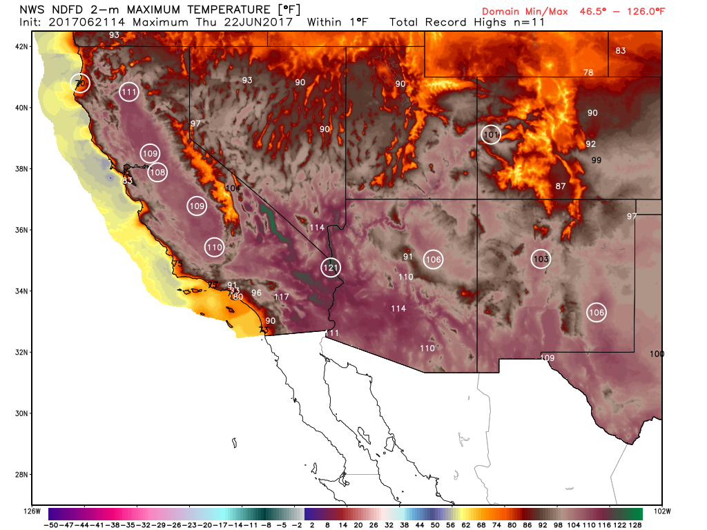
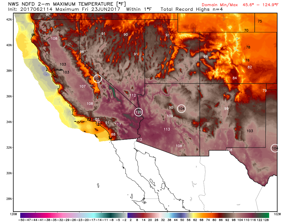
Extreme & Record Heat in Phoenix, AZ
Phoenix, AZ has been host to extremely hot temperatures over the last few days, where on Monday, June 19th, they tied a record high temperature of 118F set in 2016 that day. They also had a record high of 119F on Tuesday, June 20th, which is the 4th hottest temperature ever recorded in that city! WOW! Yuma, AZ also reached 120F on Tuesday, June 20th, which is also the 4th hottest temperature ever recorded in that cities history... that's some serious heat!
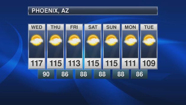
Extended Forecast for Phoenix, AZ
While the extended forecast still calls for extremely hot temperatures, it does appear that the worst may be behind us. Don't let your guard down though, high temps around 115F is nothing to sneeze at!
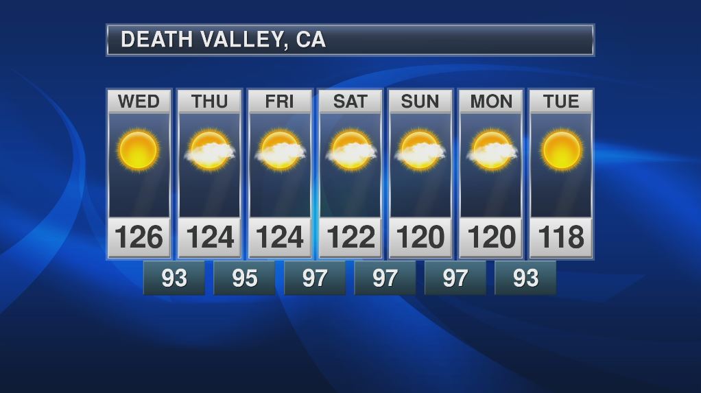
Death Valley, CA
While temperatures look to fall below 110F by early next week in Phoenix, AZ, readings in Death Valley, CA could still be up around an incredible 120F through the weekend! WOW!
"Tourists descend as temperatures climb in Death Valley"
"LAS VEGAS (AP) — Desert dwellers in the western U.S. see temperatures topping 120 degrees (49 Celsius) as a reason to hunker down indoors and turn up the air conditioning. But some tourists welcome it as a bucket-list opportunity to experience Death Valley — famously the hottest place in America. Many will get their chance in the days ahead as a vicious heatwave bakes parts of Arizona, California and Nevada. The mercury at Death Valley National Park reached 124 degrees (51 Celsius) on Sunday, and temperatures are expected to keep climbing through midweek as a dry, high-pressure system lingers over much of the Southwest. Many places saw triple-digit temperatures on Sunday, and the heatwave was blamed for power outages in several areas in California. "There's very few places on Earth to go to experience those temperatures, and Death Valley is one of those," said John Adair, a National Weather Service meteorologist."
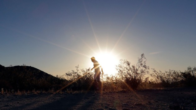
(FILE - In this June 16, 2017, file photo, a man runs through section of South Mountain Park at sunrise to avoid the excessive heat in Phoenix. (AP Photo/Matt York, File))
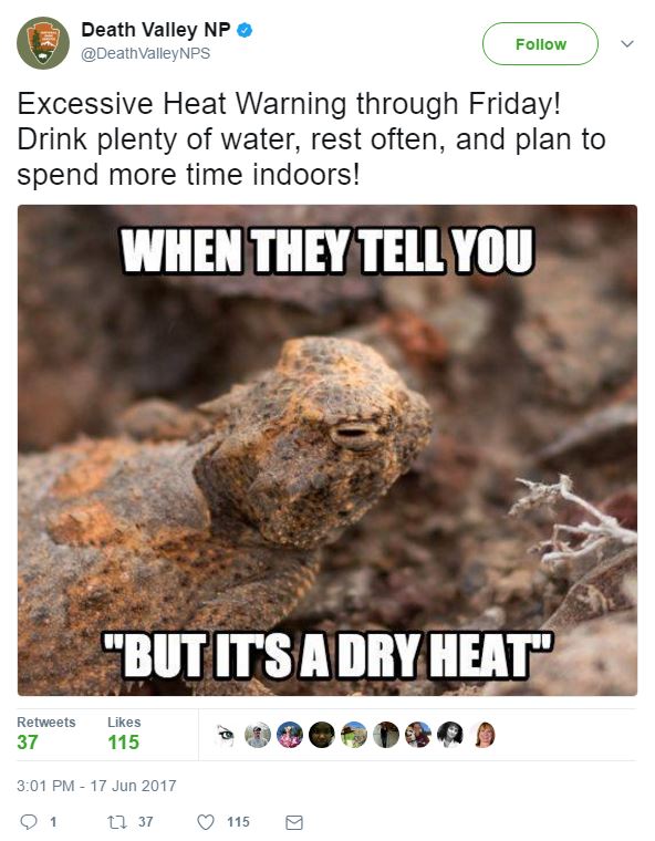
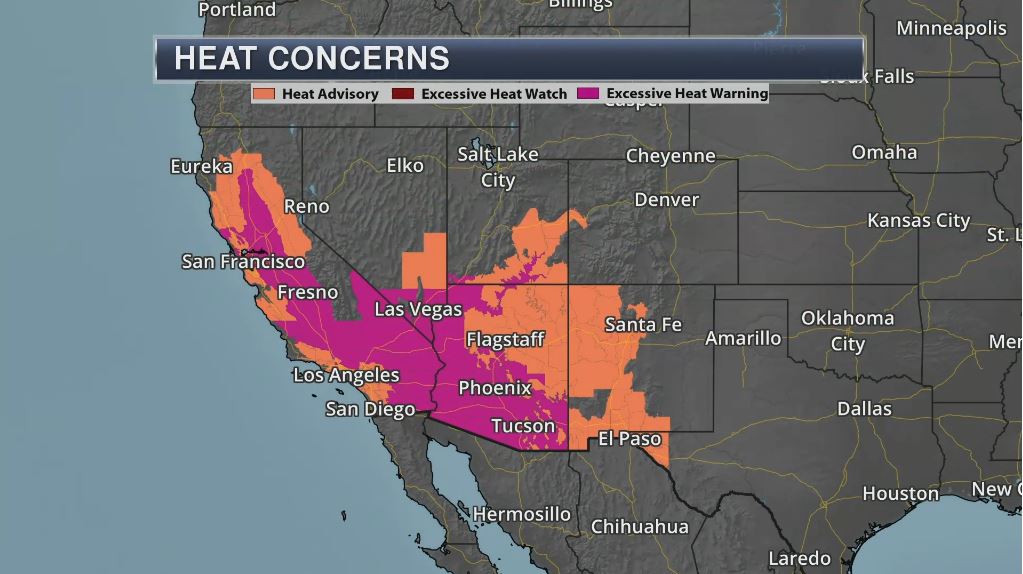
Extreme Heat Continues in the Southwest
The National Weather Service continues Excessive Heat Warnings and Advisories across a large part of the Southwest through midweek. In some cases, temperatures could be as hot as 120F+, especially for the desert locations including Death Valley, CA.
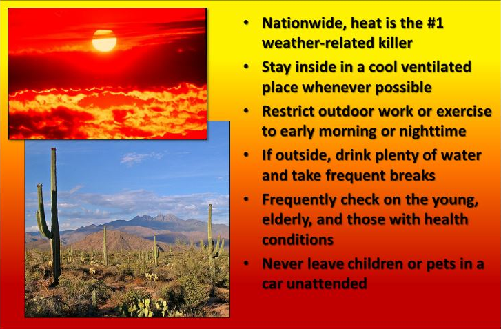
Heat is the #1 Weather Related Killer in the U.S.
"Nationwide, heat is the #1 weather-related killer. Stay inside in a cool ventilated place whenever possible. Restrict outdoor work or exercise to early morning or nighttime. If outside, drink plenty of water and take frequent breaks. Frequently check on the young, elderly, and those with health conditions. Never leave children or pets in a car unattended."
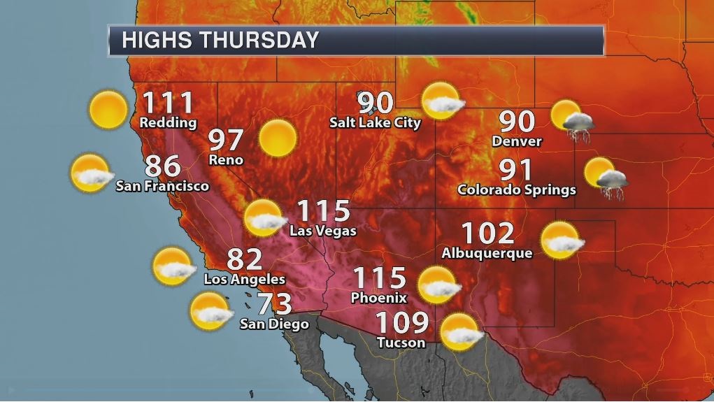
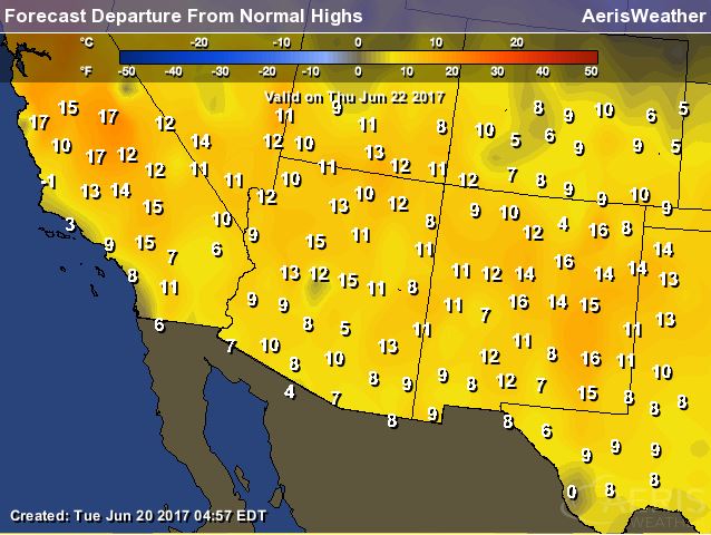
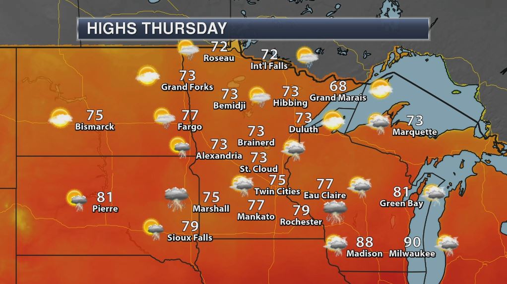
Thursday: High Temperatures - Highs Above Average - Forecast Records
It'll be another hot day in the Southwest on Thursday with temperatures still nearly 10F to near 20F above average. With readings in the 90s & 100s once again, more daily record high temperatures could fall.
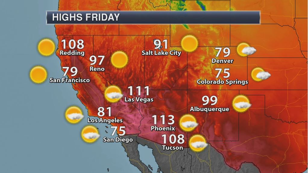
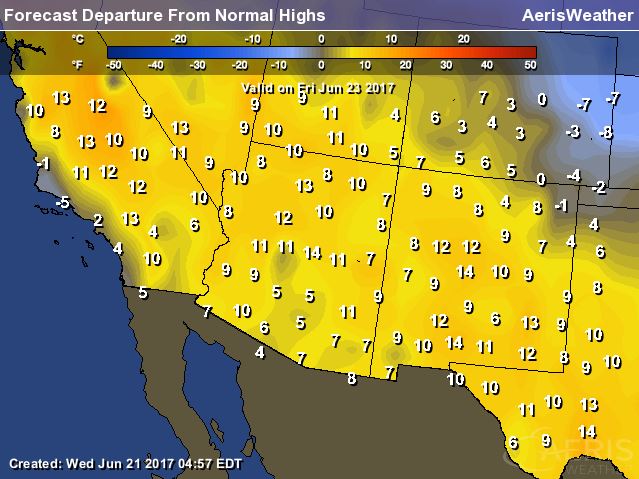
Friday: High Temperatures - Highs Above Average - Forecast Records
___________________________________________________
"When it comes to Southern California's heat wave, the worst is yet to come"
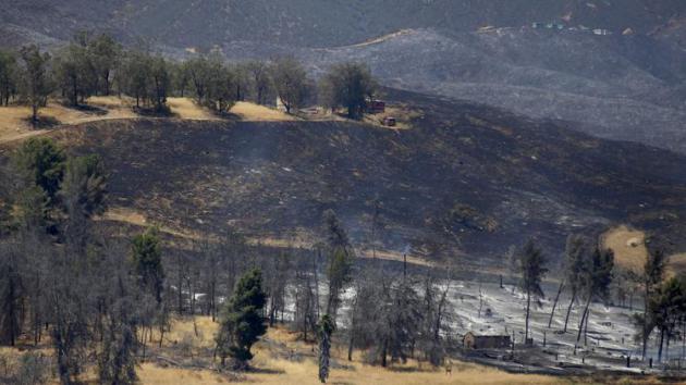
"Fiirefighters labored in scorching heat Sunday against five separate brush fires across Southern California as forecasters warned of more triple-digit temperatures in inland communities. The punishing heat wave broke records on Sunday in Lancaster, Palmdale and Sandberg, which saw highs of 108, 108 and 99 degrees, respectively. With a dry, high-pressure system parked over the Southwest, temperatures are expected to keep climbing through midweek, according to the National Weather Service."
(A brush fire near Castaic Lake burned 1,000 acres over the weekend and was only 10% contained as of Sunday afternoon. (Francine Orr / Los Angeles Times))
Weather Outlook
As we take a look at the national forecast, the main concern over the next few days will continue to be the tropical system moving into the Southern US over the next couple of days. Significant and potentially life-threatening flooding will be possible in some locations. Meanwhile dangerous heat continues in the Southwest with more record heat possible through the week.
.gif)
_________________________________________________________________
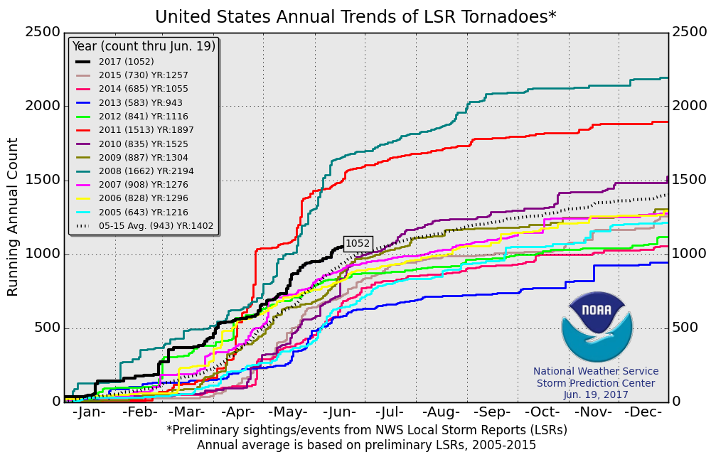
PRELIMINARY 2017 Tornado Count
According to NOAA's SPC, the PRELIMINARY 2017 tornado count is 1052 (through June 20). Note that is the most active year for tornadoes since 2011, when there were nearly 1,500 tornadoes. Keep in mind there was a major tornado outbreak in the Gulf Coast region from April 25-28, 2011 that spawned nearly 500 tornadoes, some of which were deadly. That outbreak is known as the Super Outbreak of 2011 and has gone down in history as one of the biggest, costliest and one of the deadliest tornado outbreaks in history.
________________________________________________________________________
'Refreshing' weather ahead. Warmer by the 4th
By Todd Nelson, filling in for Douglas
By Todd Nelson, filling in for Douglas
It's not too often that I can forecast well below average temperatures and get away with it. That kind of forecast in January would call for face-numbing wind chills and lots of angry tweets. In June... well, it's not too bad. Kind of refreshing, no?
With high temperatures struggling to get to 70 degrees in many locations this weekend, it may not be as lake-worthy as you'd hoped, but low humidity and a fresh breeze will make this weekend feel pretty pleasant. A few t-showers may chase you inside Saturday afternoon, but it could be worse!
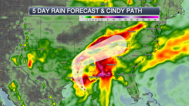
Tropical Storm Cindy is expected to bring life-threatening flash flooding along the Gulf Coast States through the end of the week before weakening in the Eastern U.S. this weekend. Cindy became the 3rd named storm of the 2017 Atlantic Hurricane Season, which is forecast to be slightly above average this season.
Lingering showers and storms work through southern Minnesota today before more sun returns Friday. Hot & sticky weather will resume in July, it always does.
Hey, it's summer in Minnesota!
______________________________________________________
______________________________________________________
Extended Forecast
THURSDAY: Some sun. Lingering T-shower, mainly southern MN. Winds: NNW 5-10. High: 76.
THURSDAY NIGHT: Lingering thundershower early, then clearing later. Winds: W 5. Low: 56
FRIDAY: Refreshing. Sun and cloud mix. Winds: NW 10-15. High: 73
SATURDAY: Chilly for June. A few PM showers. Winds: WNW 5-10. Wake-up: 54. High: 69
SUNDAY: Still cool. Stray afternoon rumble. Winds: WNW 5-10. Wake-up: 54. High: 72
MONDAY: More sun. Pleasant. Winds: W 5-10. Wake-up: 56. High: 74
TUESDAY: Warming temps. Late day rumble? Winds: SSE 5-15. Wake-up: 59. High: 78.
WEDNESDAY: Chance of showers and storms. Winds: ESE 5-10. Wake-up: 62. High 81.
_______________________________________________________
_______________________________________________________
This Day in Weather History
June 22nd
June 22nd
1988: Smoke fills the sky across much of Minnesota due to wild fires during the '88 drought.
1919: The 2nd deadliest tornado in Minnesota history hits Fergus Falls, killing 59 people. Like the #1 killer tornado for Minnesota (73 fatalities in St. Cloud and Sauk Rapids on 4/14/1886), it struck on a weekend.
1917: Grand Meadow has an intense downpour, and 4.98 inches of rain on this date. Corn crops are badly damaged by the heavy rain/flooding.
________________________________________________________
________________________________________________________
Average High/Low for Minneapolis
June 22nd
June 22nd
Average High: 81F (Record: 98F set in 1911)
Average Low: 61F (Record: 42F set in 1960)
Average Low: 61F (Record: 42F set in 1960)
Record Rainfall: 2.12" set in 1930
_________________________________________________________
_________________________________________________________
Sunrise/Sunset Times for Minneapolis
June 22nd
June 22nd
Sunrise: 5:27am
Sunset: 9:03pm
Sunset: 9:03pm
Hours of Daylight: 15hours & 36mins & 43 seconds
Daylight LOST since yesterday: 5 seconds
Daylight LOST since summer solstice (June 20th): 5 seconds
__________________________________________________________
Daylight LOST since summer solstice (June 20th): 5 seconds
__________________________________________________________
Moon Phase for June 21st at Midnight
1.8 Days Before New Moon
1.8 Days Before New Moon

_____________________________________________________________
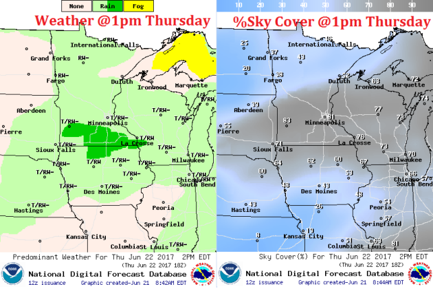
Weather Outlook for Thursday
Winds will be fairly light across the region on Thursday, but could be a little gusty if any thunderstorms move in. Winds will also turn out of a more westerly direction through the day, which will help to draw in much cooler air for the upcoming weekend.
Weather Outlook for Thursday
Lingering showers and storms will be possible across the region on Thursday. Note that the best chance of more organized thunderstorms will be possible across southern MN through the day, while the strong to severe thunderstorm potential will slide farther south into Iowa and Wisconsin.
__________________________________________________________________________
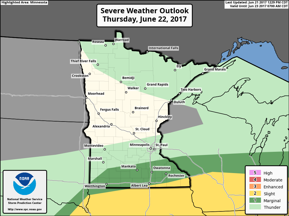
Severe Threats Move South Thursday
Here's the severe threat for Thursday, which shows the best potential of strong to severe storms sliding south into Iowa and Wisconsin. However, there still could be a few isolated strong storms across far southern MN.
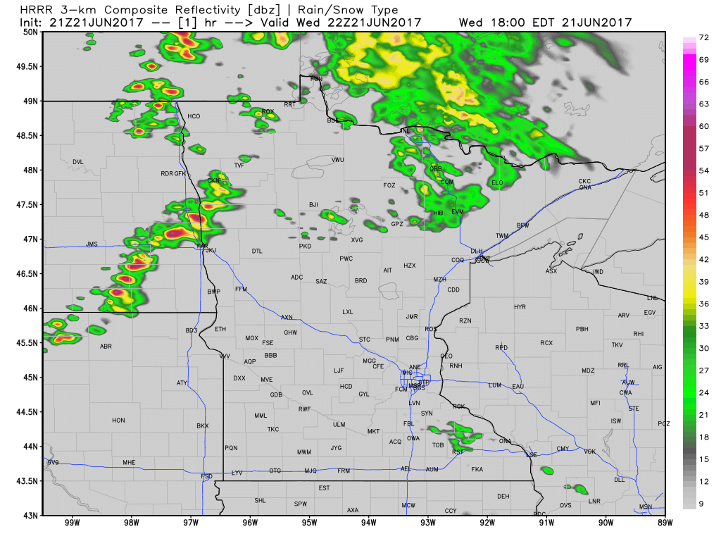
Midweek Storms, Some Strong With Locally Heavy Rainfall
Here's the weather outlook through late Thursday morning, which shows our next chance of showers and storms pushing through the region. Note that some of these storms could be strong to severe.
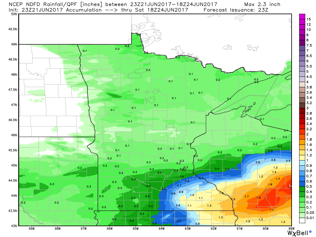
Extended Rainfall Forecast
Here's the extended rainfall forecast through midday Saturday, which suggests nearly 0.50" to 0.75" rain across southeastern MN, while 0.25" to 0.50" maybe possible across the Twin Cities. Of course, this will be dependent upon where thunderstorms develop.
________________________________________________________________________
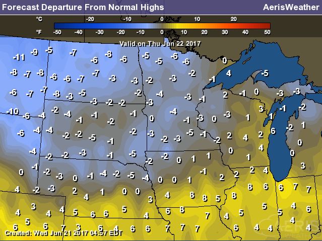
Weather Outlook For Thursday
High temperatures on Thursday will begin cooling down in the wake of the front that brought us a few strong storms across the region late Wednesday. Note most locations will be in the 70s, which will be nearly 5F below average.
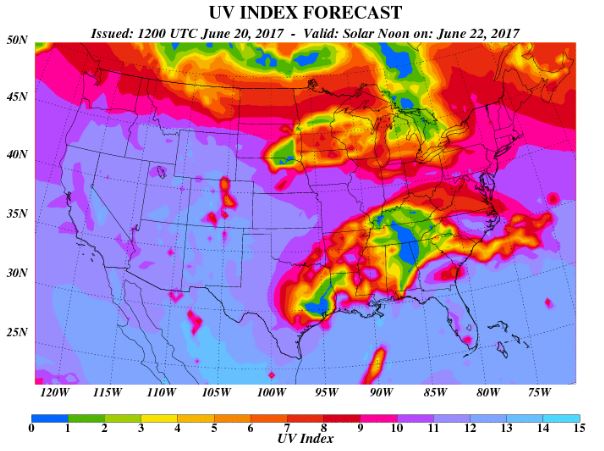
UV Index for Thursday - HIGH
The UV Index will be considered HIGH across much of the state of Minnesota on Thursday, which means that it will only 20 to 30 minutes or less to burn unprotected skin. With that said, if you are planning on spending any extended length of time outside, make sure you wear appropriate attire and lather on the sun block!
_____________________________________________________________
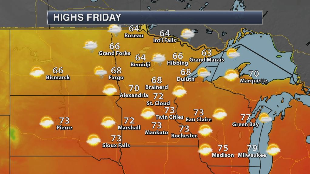
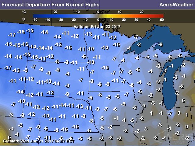
Weather Outlook for Friday
Friday will be even cooler with highs across the northern half of the state not even warming into the 70s. The southern half of the state will be able to warm into the lower 70s, but this will still be nearly 10F below average. The forecast into the weekend calls for similar if not even slightly cooler readings. The Twin Cities might even have a hard time reaching 70F!
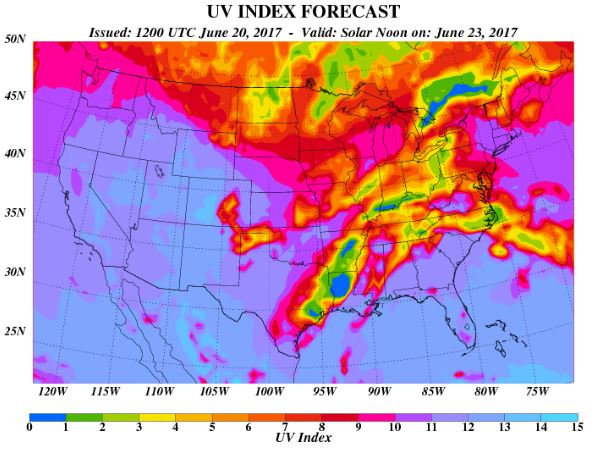
UV Index for Friday - HIGH
The UV Index will be considered HIGH across much of the state of Minnesota on Thursday, which means that it will only 20 to 30 minutes or less to burn unprotected skin. With that said, if you are planning on spending any extended length of time outside, make sure you wear appropriate attire and lather on the sun block!
"Overlooking This Tiny Detail on a Sunscreen Bottle Causes Major Skin Burns"
"It's 2017, and by now, we're well aware of the risks of tanning. We know to apply sunscreen every two hours, we know to put it on for all outdoor activities, and we know how important it is to apply even when it's cloudy. But what about expired sunscreen? What happens if we're following all the sun protection rules, but still manage to get a horrible sunburn because of an old bottle of sunscreen? I fell victim to a sunscreen expiration date, and now, it's the first thing I check before applying SPF."

_____________________________________________________________________________
Temperature Outlook
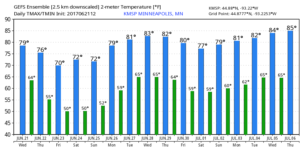
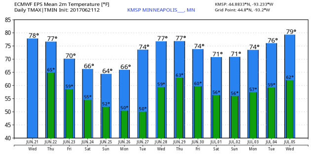
Here's the temperature outlook from 2 different models through into the early part of July. After a slight warm up back to near 80F on Wednesday & Thursday, the weekend looks quite chilly with highs that may struggle to get to 70F! After the brief weekend cool snap, temperatures look to steadily warm as we approach the the start of July. There are some indications that it could be hot & sticky around the 4th of July, but it's a little too early to tell. Stay tuned!
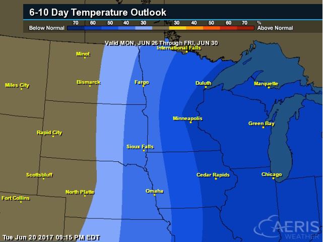
8 to 14 Day Temperature Outlook
According to NOAA's CPC, the extended temperature outlook through June 30th suggests much cooler than average temperatures across the entire region. After a very warm start to the month, temperatures looks to remain cool as we end the month. As of June 19th, the Twin Cities was still running nearly 7F above average for the month, but with continued cooler temperatures, we'll see how June ends.
___________________________________________________________
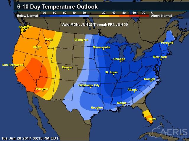
Extended Temperature Outlook
According to NOAA's CPC, the extended temperature outlook through June 30th shows much cooler than average temperatures across a good chunk of the central US and into the Northeast. Warmer than average temperatures look to continue across the Western third of the nation and across Florida.
 ____________________________________________________________
Temperature Trend
Here's the temperature trend through the end of the month, which shows cool exhaust from Canada continuing to settle south of the border over the next several days. The coolest batch of Canadian air may come in waves; one chunk over the upcoming weekend with another smaller batch moving into the Midwest/Great Lakes by the early/middle part of next week. Meanwhile, the Western US looks to remain quite hot through the end of the month.
.gif)
Weather Outlook This Week
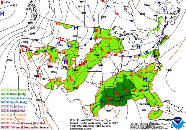
The weather outlook over the next couple of days shows the tropical system in the Gulf of Mexico moving north into the Lower Mississippi Valley with gusty winds and significant rain and flooding potential. Meanwhile, scattered storms breakout across the Central US, some of which could be strong to severe with locally heavy rains.
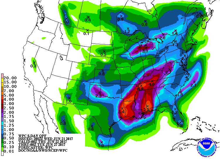
5 Day Precipitation Outlook
According to NOAA's WPC, the next several days could produce areas of locally heavy rainfall across the South US where some 6" to 10"+ rainfall tallies can't be ruled out. Note that some of this tropical moisture may lift northeast into the Ohio and Tennessee Valley through the upcoming weekend, which could also lead to areas of flooding. Another batch of heavier rain could fall across the Midwest and Great Lakes Region, which would be associated with scattered to spotty severe storms through the end of the week.
 ____________________________________________________________________
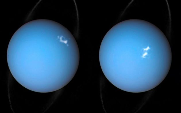
"NASA wants to probe Uranus in search of gas"
"We hear a lot about Mars, Jupiter, and Saturn, and that’s because we have extremely fancy hardware floating around and, in some cases, cruising on the surface of those planets. The planets that lie further away from the Sun don’t get nearly as much attention, but they may soon, as NASA is currently spitballing some missions that will give us a better look at Uranus than we’ve ever gotten. The theoretical missions, which would see NASA spacecraft heading to both Uranus and Neptune, would be of huge scientific benefit. The idea is to determine what the planets are made of, get an idea of the atmospheric composition, and take lots of fantastic photographs, too. Researchers hope to study the weather and overall climate of the planets, while determining how they fit into the overall makeup of our Solar System."
____________________________________________________
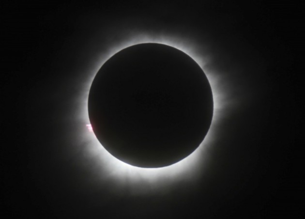
"How to avoid clouds that could spoil the Great American Eclipse"
"You’ll hear it again and again. The Aug. 21 total solar eclipse is a once in a lifetime celestial event, and a mind-blowing experience awaits those who witness it. It is being called the “Great American Eclipse;” the last comparable event occurred 99 years ago. But, depending where you go, clouds could play spoiler. Inevitably, some people who spend hundreds or even thousands of dollars to travel to view the spectacle could have their experience completely ruined by overcast skies. Fortunately, the National Oceanic and Atmospheric Administration (NOAA) has developed a website that provides detailed information about which locations have the best chance of skies clear enough to view the eclipse."
(A total solar eclipse in Belitung, Indonesia, on March 9, 2016. (AP))
___________________________________________________________
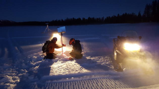
"Measuring the snowpack goes high-tech with airborne lasers and radar"
"Every year for almost half a century, California snow surveyor Pat Armstrong has trekked the rugged Sierra Nevada with three simple tools: a snow core tube, a scale and a notebook. For as long as he can remember, state water officials have relied on the accuracy of those tools to deliver crucial data on the size of the Sierra snowpack and its ability to sustain a growing population. “It hasn’t changed in a hundred years,” Armstrong said of the survey. But there is a growing belief that this low-tech process alone is becoming too unreliable to accurately manage California’s water needs. A warming climate, experts and officials argue, has ushered in a new age of unpredictable rainy seasons and caused the Sierra snowpack — the state’s largest naturally occurring reservoir — to melt faster than ever before. Knowing how much snow is available is essential to maintaining California’s water supply and minimizing flooding when the snow melts.
(Researchers with NASA's SnowEx project at a study site at Island Lake in the San Juan Mountains in Colorado on Feb. 15. (NASA Hydrological Sciences))
___________________________________________________________________
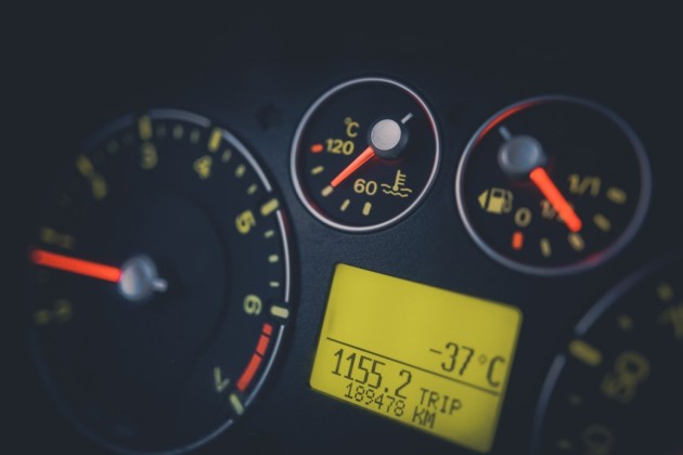
"This is why your car thermometer is almost always wrong"
"Few industries integrate technology into their products faster than do automobile companies. One of those features, now ubiquitous in most cars, is the dashboard thermometer display. But the temperature reading on your vehicle’s dashboard is often misleading and not representative of the actual temperature. In its most basic definition, temperature is a measurement of how fast gas molecules are moving or its average kinetic energy. Heat excites molecules, causing them to bounce around much more frequently, resulting in a higher temperature value. The most common way to measure this reaction is with a mercury thermometer, where the liquid mercury will physically expand and rise to a particular value when heat is added. Your car is equipped not with a thermometer but with a thermistor. Thermistors work in a similar manner to thermometers, but rather than using a liquid like mercury, thermistors measure the change in electrical current as a result of heat added or taken away. Thermistors are quite convenient, since they are small, cheap to make and for the most part, accurate. And really, the problem is not that your car uses a thermistor but rather where that thermistor is placed."
(image credit: WashingtonPost)
________________________________________________________________
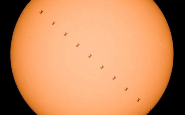
"Incredible image shows International Space Station passing in front of the sun"
"This incredible composite image, showing the International Space Station's transit past the sun, was taken at Csakanyhaza in Slovakia, close to the Hungarian border and around 150km north-east of Budapest. The ISSN took one second to pass across the sun - and the picture above is made from 11 separate exposures taken at regular split-second intervals."
(This combination photo shows the International Space Station as it flies in front of the sun CREDIT: EPA/PETER KOMKA HUNGARY OUT)
"Weather system revamp hopes to bring sunshine to US economy"
"New legislation requires NOAA to improve weather research and forecasting, boosting industries from farming and airlines and improving the public warning system"
"Farmers have been obsessed with weather for thousands of years. Ancient Greeks and Babylonians sought guidance on planting and harvest by surveying the sky for patterns in clouds and stars and by communing with gods – through prayers and animal sacrifices. Modern-day farmers, such as Steve Pitstick, a fifth-generation farmer in Illinois, count on sophisticated instruments for predicting the weather instead. During the planting season, Pitstick says, he checks the weather forecast three or four times a day. Too much rain means he can’t plant because the heavy machinery will compact the wet soil, smothering the seeds; too little and the seeds won’t germinate. “Weather is huge in our business. We use the forecast during planting season to get a sense of what we’re doing and to know the level of urgency to get the crops planted,” says Pitstick, who grows corn and soybeans. Weather is big business in many other industries, too, and an ambitious plan is underway to revamp the country’s weather forecast system. It’s the Weather Research and Forecasting Innovation Act of 2017, the first major weather legislation that Congress has passed since the early 1990s."
_______________________________________________________________
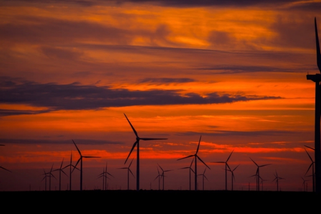
"The U.S. Hit a Wind and Solar Power Milestone in March"
"Ten percent of all of the electricity generated in the U.S. in March came from wind and solar power, marking the first such milestone in U.S. history, according to a new U.S. Energy Information Administration report. The EIA estimates that wind and solar farms likely generated 10 percent of America’s electricity in April as well, which would be another first, according to the report. This year’s milestone shows that renewables are becoming a major source of electricity in the U.S. and can no longer be considered “alternative” energy, said Christopher Clack, CEO of the power grid modeling firm Vibrant Clean Energy and a former National Oceanic and Atmospheric Administration researcher. The report’s findings represent a marked increased from March 2016, when wind and solar generated 8.6 percent of total U.S. electricity. Overall, about 7 percent of U.S. electricity comes from wind and solar annually, up from less than 1 percent a decade ago. Texas is the country’s biggest wind power producer and California is the largest solar producer."
(The Los Vientos wind farm in Texas. Credit: Duke Energy/flickr)
_______________________________________________________
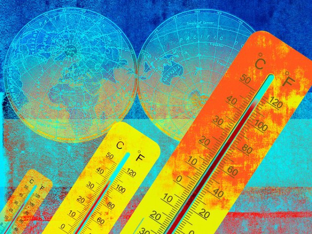
"IS IT SO BAD IF THE WORLD GETS A LITTLE HOTTER? UH, YEAH"
"MANY OF US share some dim apprehension that the world is flying out of control, that the center cannot hold. Raging wildfires, once-in-1,000-year storms, and lethal heat waves have become fixtures of the evening news—and all this after the planet has warmed by less than 1 degree Celsius above preindustrial temperatures. But here’s where it gets really scary. If humanity burns through all its fossil fuel reserves, there is the potential to warm the planet by perhaps more than 10 degrees Celsius and raise sea levels by hundreds of feet. This is a warming spike comparable in magnitude to that so far measured for the End-Permian mass extinction. If the worst-case scenarios come to pass, today’s modestly menacing ocean-climate system will seem quaint. Even warming to half of that amount would create a planet that would have nothing to do with the one on which humans evolved, or on which civilization has been built. The last time it was 4 degrees warmer there was no ice at either pole and sea level was hundreds of feet higher than it is today."
(Image Credit: GETTY IMAGES via Wired)
_______________________________________________________
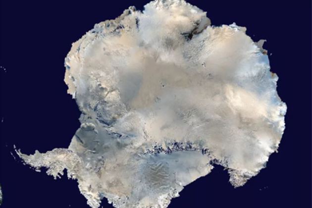
"Unusual weather in Antarctica leads to rain and a Texas-sized melt"
"An area larger than the state of Texas in West Antarctica melted to an unusual degree last year, with pools of the meltwater remaining on the surface for as long as 15 days. That’s trouble, since meltwater can accelerate the thawing already occurring from warming ocean temperatures. West Antarctica alone could contribute 10 feet of sea level rise, according to a 2009 paper published in Science. This area in the Ross Ice Shelf, the world’s largest chunk of floating ice, likely melted at its surface because of a particularly strong 2015–2016 El Niño event, which brought warm and moist sea air to the area, according to the study published today in Nature Communications. El Niños have caused melting atop the Ross Ice Shelf before, but this time it lasted unusually long, according to the paper. It appears it also rained on the ice shelf and other parts of West Antarctica. That could made it easier for the snow surface to melt."
(Image Credit: NOAA)
Thanks for checking in and don't forget to follow me on Twitter @TNelsonWX

No comments:
Post a Comment