.29" rain fell in St. Cloud yesterday.
73 F. Thursday high temperature.
80 F. average St. Cloud high on June 22.
84 F. high on June 22, 2016.
June 23, 2002:
Just a few weeks after torrential rains hit the area, another round of
heavy rain hits northern Minnesota. This time up to eight inches would
fall in a two-day period in parts of Mahnomen and St. Louis Counties.
 A Cool and Showery Bias Into The 4th of July?
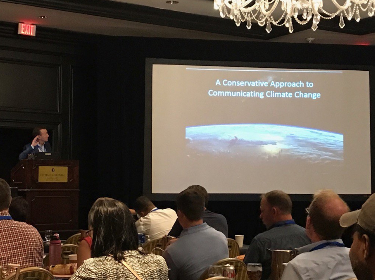
I
just got back from Kansas City, where I gave a talk to America's TV
meteorologists on climate messaging for conservatives; framing that
highlights faith as well as science. Not sure it moved the needle, but I
sense more traction with stewardship and Creation Care.
The
increase in warm season rainfall is most pronounced in the Midwest and
New England. Large hail MAY be on the increase, but it's unclear whether
background warming has a role. Expanding suburbs means more expensive
targets for severe weather to strike. Normalization of socioeconomic
trends is an ongoing challenge.
I'm stalling because I really
don't want to talk about weekend weather, or the 4th of July for that
matter. A stubborn wrinkle of cold air aloft keeps us cool and showery
this weekend with highs in the 60s. We warm up next week, but long-range
models show another cooling trend in time for the 4th of July weekend.
Upper 70s and low 80s for highs with spotty T-showers? We've seen worse.
Not
exactly a postcard-perfect holiday but unlike Phoenix you won't burn
the bottom of your feet walking the dog. Great news: no worries about
heat stroke/sunburn anytime soon!
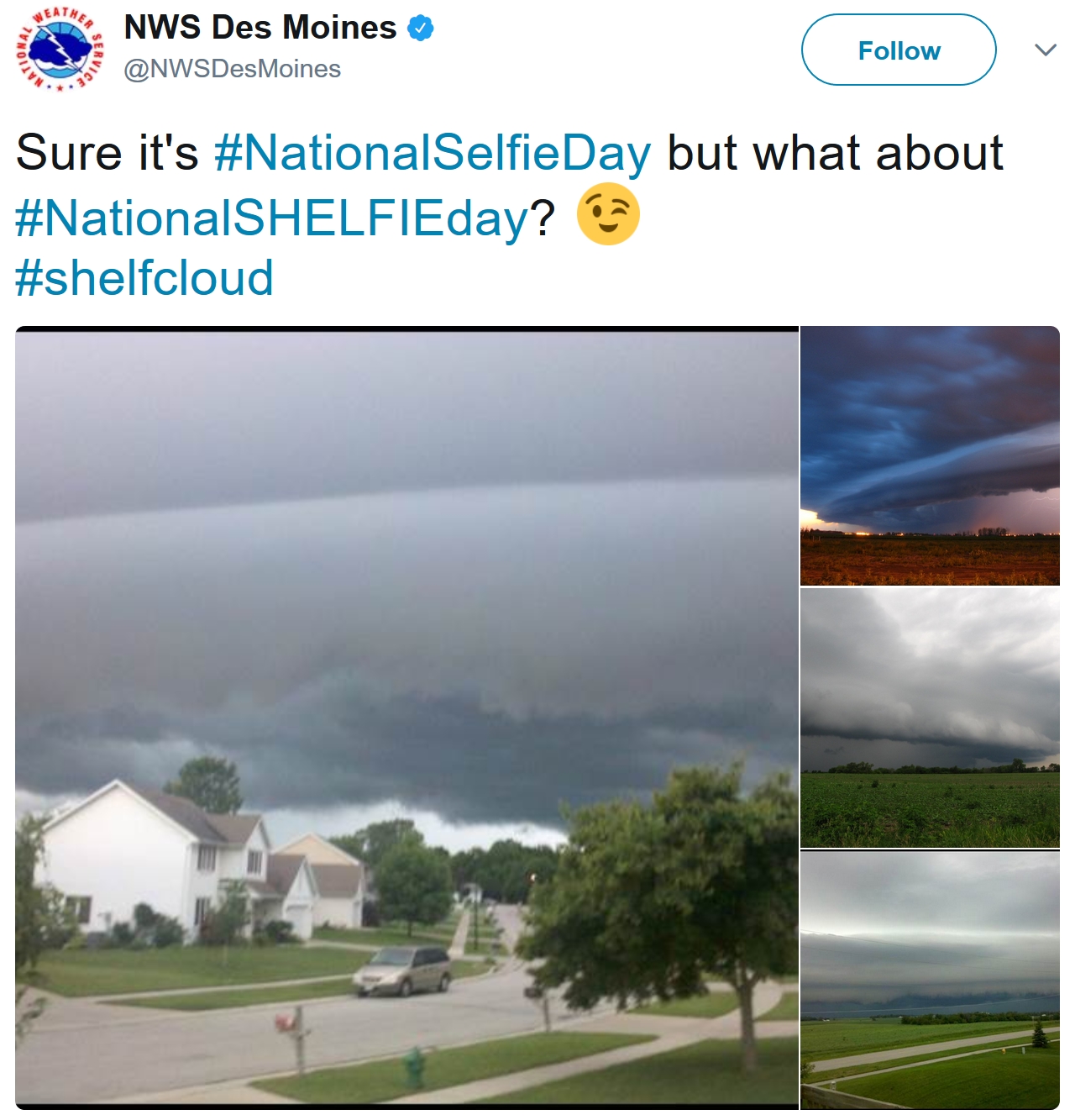
Photo credit: WCCO-TV meteorologist Mike Augustyniak. Thanks Mike!
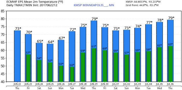
Cool Bias Hangs On.
No signs of sweltering heat spreading into Minnesota and Wisconsin, at
least not looking out 2 weeks or so. A series of cool frontal passages
will keep temperatures 5-10F cooler than average; highs mostly in the
70s through the period. Except for tomorrow and Sunday, when metro highs
may not climb out of the 60s. ECMWF guidance: WeatherBell.
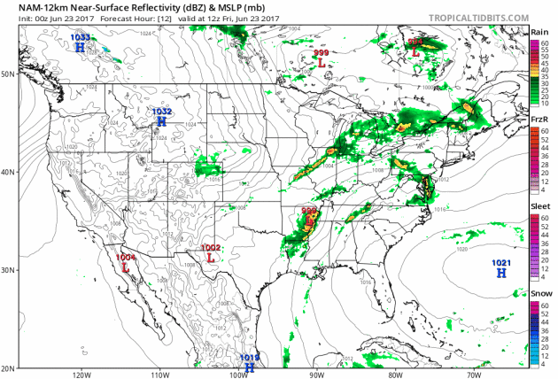
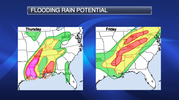
Tracking the Soggy Remains of Cindy.
12 km NAM guidance suggests the core of heaviest rain will track from
Memphis to Louisville and Cincinnati today, possibly soaking Washington
D.C. and Philadelphia with a few inches of rain by Saturday. A flush of
Canadian air sparks instability showers from the Upper Midwest into the
Great Lakes and New England, while strong to severe storms sprout from
the southern Plains into the southeastern USA. The west coast stays
mostly dry, with sizzling heat lingering over the southwest. 84 hour
Future Radar: NOAA and Tropicaltidbits.com.
Hot Air Expanding North Second Week of July?
The worst of the heat wave continues to grip the southwestern USA, but
GFS forecasts for 500 mb looking out roughly 2 weeks suggest that heat
may spread into the Midwest, Ohio Valley and Great Lakes. Remember that
July is, historically, the hottest month of the year.
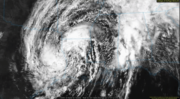
Sloppy Remnants of Tropical Storm Cindy. This (non-operational) GOES-16 visible loop (courtesy of the
College of DuPage Nexlab,
was taken yesterday during the early afternoon hours; a
counterclockwise swirl of tropical moisture pushing flooding rains inito
the Gulf Coast and Mid South.
Here is an excerpt of a Praedictix corporate briefing issued yesterday by meteorologist D.J. Kayser:
Heavy Rain Over The Past Few Days. Rainfall
totals have already topped 8” in Gulfport, MS, and 9” in Pensacola, FL,
over the past three days due to Cindy. This has caused flooding across
the region, and any additional rain will only continue to prolong the
issue.
Official Forecast Track. Steady weakening is expected throughout the day, with Cindy expected to become post-tropical
tonight.
The system will gradually make a turn northeast and accelerate over the
next couple days, merging with a frontal system as we head into the
weekend. Heavy rain that could cause significant flooding continues to
be the main threat with Cindy. As of
7 AM CDT, a Tropical Storm Warning was in effect from High Island, TX to Morgan City, LA.
Additional Rain Potential. Additional
heavy rain of 2-8” is expected over the next couple days on top of the
5-10” of rain that has already fallen along the northern Gulf Coast.
This rain will only further increase the potential of flooding across
the region, and could result in significant, potentially
life-threatening flash flooding with many streams and rivers leaving
their banks. Meanwhile, heavy rain will continue to spread north into
the Tennessee and Ohio Valleys as the remnants of Cindy moves across the
region, bringing the potential of 1-4”+ of rain.
Flash Flood Watches Continue. Due
to the heavy rain threat, Flash Flood Watches continue across the
region - as far north as Tennessee and Missouri. Due to significant rain
that has already fallen along the northern Gulf Coast, any additional
rainfall continues to pose the threat of life-threatening flash
flooding. Due to the prolonged nature of the rain, the flooding
potential could exist for some time.
Flash Flood Potential.
Some of the heaviest rain today will occur along and in front of the
overall path of Cindy. These areas have the best potential of 3-5" of
rain today, with isolated totals up to a foot. Due to this,
life-threatening flash flooding could occur across parts of eastern
Texas, western Louisiana and southern Arkansas, leading to a “high” risk
of excessive rainfall that could lead to flooding from the Weather
Prediction Center. The flooding threat will continue into
Friday as the system continues north and northeast into the Ohio and Tennessee Valleys.
Meanwhile the southwestern USA continues to bake:
 The Science Behind Arizona's Record-Setting Heat Wave.
 Here are a few nuggets from
Pacific Standard that made me do a double-take: "
In
the Arizona desert, as far back as weather records go, it's never been
this hot for this long. By early Monday afternoon, the temperature was
111 degrees in Tucson, the first in a forecasted series of a record-setting seven consecutive days
with highs above 110, the longest streak in city history. (The previous
record, should it fall, was six days in a row in 1994.)...
- The United States Border Patrol stepped up safety messages, saying "it is physically impossible for the average person to carry enough water to survive."
- The National Weather Service also warned against walking pets outdoors, saying that at pavement temperatures above 162 degrees (consistent with air temperatures of 102), skin is instantly destroyed.
Also on Monday, American Airlines canceled 38 flights previously scheduled for Phoenix on Tuesday—simply because it will be too hot to fly..."
Seriously Hot. Check out a
Reddit photo
taken on Wednesday in the greater Phoenix area, showing a surface
temperature of 168F. Asphalt + 120 F air temperature = first and second
degree burns. Imagine living in your oven. That's what much of the
southwestern USA is enduring this week.
Hot Dog Booties? Every threat is an opportunity.
Esquire has a photo essay that includes the picture above and a photo credit from Tempe, Arizona: "
Since hot pavement can burn dogs' paws, Phoenix radio station KSLX handed out protective booties at a PetSmart in Tempe, Arizona."
 Phoenix: Second-Fastest Warming City in the USA. Praedictix
 meteorologist Kristin Clark explains: "...
In the U.S. Phoenix is the second-fastest warming city over
the past 50 years. We are fortunate in the States to have access to
cooling technologies. Yet the increasing frequency of heat waves will
negatively impact health with more heat-related illnesses like heat exhaustion and heat stroke.
Diseases could spread as insects thrive in newly warmed regions. More
days with poor air quality will lead to asthma and poor respiratory
health. Stresses on crops and worsening drought will impact
agriculture. Elevated strains on the energy grid grow as demand for air
conditioning increases. The use of energy increases as well as cooling
costs. Hot how will it get at your house this week? Be sure to check
the Praedictix local, regional and national forecast..."
New Tools To Help Visualize the Future of Drought. These new
NOAA NCEI maps provide the perspective necessary to try and answer tough questions related to moisture. Here's an excerpt from the
U.S. Drought Portal: "
How
much rain is it going to take for this drought to get better? What’s
the likelihood that the drought will be over a month from now? If it
doesn't rain again for the rest of the month, how bad could the drought
get? Questions like these start creeping in when the landscape browns,
when streams get low, when the sun starts baking our gardens.
Californians were among those contemplating such things as drought
intensified there from 2011 into this past winter. Folks in the Dakotas
are asking those questions now. How bad can it get? There’s a tool that
can help answer. Drought Termination and Amelioration pages from NOAA’s National Centers for Environmental Information (NCEI) offer a customizable interface anyone can use to find information on..."
Map credit: "
Based
on the PHDI. PHDI is a primary measure of long-term drought but may not
apply to all areas, including those with heavily managed surface water.
No additional precipitation is needed for white areas. Values are in
inches."

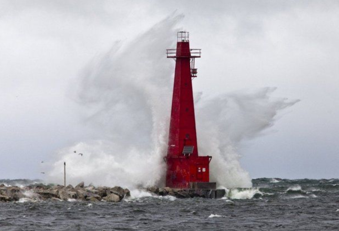 Warning System for Great Lakes Tsunamis Under Development
. I had no idea - here's a clip from a fascinating article at
MLive.com: "...
Rapid
changes in barometric pressure, often associated with fast-moving
weather systems, can generate meteotsunamis. Although many meteotsunamis
are too small to notice, large meteotsunamis can have devastating
coastal impacts, including damaging waves, flooding and strong currents,
that cause significant damage, injury and death. An average of 106
meteotsunamis are observed each year, according to the CIGRL. For
example, in 2003 in Sawyer, seven people drowned in an incident
initially attributed to rip currents, though the water level records
indicated a moderate meteotsunami occurred around the time of the
drownings..."
Photo credit: "
A wave crashes over the pier at Pere Marquette Park in Muskegon Friday, Oct. 31, 2014." (Cory Morse | MLive.com).
Preparing for the Storm: Predicting Where Our Coasts Are At Risk. It's a complicated matrix of regular tidal forcings, sea level rise, land subsidence and storm-surge flooding, according to
USGS: "...
What
Bandy needed was a model that accounted for waves breaking on the
beach, for the shifting shape of the Outer Banks’ beaches and dunes, and
how and where the interaction could cause coastal erosion. “That’s
information the U.S. Geological Survey [USGS] can provide,” said Hilary
Stockdon, project lead for the USGS National Assessment of Coastal
Change Hazards (NACCH). The USGS created a model that accurately
predicts which areas of the beach are at risk to overwash or flooding
from impending nor’easters and hurricanes. Combined with the offshore
wave forecasts of the NWS, meteorologists like Bandy can now speak in
specifics when warning officials and residents. The USGS created the
model using more than a decade of carefully gathered data on how storms
affect coastlines and by merging models of coastal waves and water
levels with detailed mapping..."
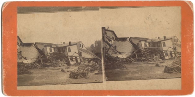
The World's Most Catastrophic Floods, in Photos. The History Channel reviews some of the biggest killers on record, including the Great Johnstown Flood of 1889: "...
The disaster began
shortly after 3 p.m on May 31, 1889, when a dam on Pennsylvania’s Lake
Conemaugh washed away following several days of drenching rain. The
collapse unleashed some 16 million tons of water, which quickly turned
into a 40-foot-high, half-mile-wide surge of mud and debris. An hour
later, the wave struck Johnstown like a giant fist, crushing some 1,600
buildings and sweeping away everything in its path. When the waters
finally receded, over 2,200 people were dead and many more were injured
or homeless. The flood was later blamed on the poorly maintained dam,
which was owned by a hunting and fishing club, but no one was ever held
financially liable for the disaster..."
NOAA Data Helps Retail and Manufacturing Business Minimize Impacts from Weather and Climate. Here's an excerpt from
NOAA NCEI: "...
In
the winter, in particular, the weather can dramatically influence
economic activity related to the manufacturing and retail industries. A
severe snowstorm may keep consumers from shopping at retail stores and
dining at restaurants. And, winter weather can prevent goods from
getting to market too. For example, when a major snowstorm caused a
single-day shutdown in New York, it resulted in $152 million in lost sales (link is external).
However, major snowstorms can be profitable for online retailers and
the automotive repair industry. Since they account for $3.2 trillion or
17 percent of the U.S. GDP and an estimated 22 million jobs
collectively, the performance of the manufacturing and retail industries is a top indicator of economic well-being.
With the right data, manufacturers, retailers, and the companies that
invest in them can understand and measure how weather is influencing
their bottom lines and the country’s economy..."
File photo: Pixabay.com.
Senators Push Trump for Answers on Power Grid Malware Attack.
Could one smart hacker sitting in his mother's basement on the other
side of the world bring down the U.S. power grid? Here's a clip from a
troubling story at
WIRED.com: "
In one of his first public statements on his priorities as president, Donald Trump promised
to develop a "comprehensive plan to protect America's vital
infrastructure from cyberattacks." That has not yet materialized. And as
new evidence has emerged that a piece of sophisticated malware caused a blackout in the Ukrainian capital last December, one group of senators wants answers now about the threat of Russian grid-hacking. In a letter to the president
Thursday, 19 senators have called on the White House to direct the
Department of Energy to conduct a new analysis of the Russian
government's capabilities to disrupt America's power grid..."
 Fisticuffs Over The Route to a Clean-Energy Future
.
Could the U.S. economy run on entirely-renewable sources like wind,
solar and hydro? Probably not with today's antiquated grid, reports
The New York Times: "
Could
the entire American economy run on renewable energy alone? This may
seem like an irrelevant question, given that both the White House and
Congress are controlled by a party that rejects the scientific consensus
abouut human-caused climate change. But the proposition that it could,
long a dream of an environmental movement as wary of nuclear energy as
it is of fossil fuels, has been gaining ground among policy makers
committed to reducting the nation's carbon footprint. Democrats in both
the United States Senate and in the California Assembly have proposed
legislation this year calling for a full transition to renewable energy
sources..."
Head of the American Meteorological Society to Secretary of Energy: You're Dead Wrong on Climate. Meteorologist Dan Satterfield has a post at
AGU Blogosphere: "
There
is just no doubt anymore that the warming of the last century is due to
rising greenhouse gases in the atmosphere. Yes, there are a ton
of myths out there but no one who understands the basic science has any
doubt. Even the latest surveys show that among those in the field the
agreement is over 99%.
So, when the Secretary of Energy goes on TV and says things that are
preposterous, someone should correct him. Keith Seitter, the Exec.
Director of the American Meteorological Society, has done just that..."
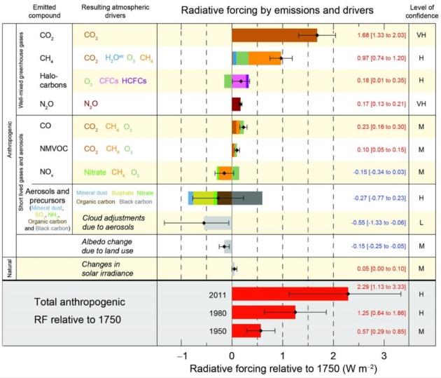
Image credit: "It’s the math. I’m quite sure that atmospheric scientists will be happy to explain this graphic to Secretary Perry." From the IPCC 2013.
Perry's Climate Change Comment "Flies in the Face of Science", Moniz Says. The Houston Chronicle reports: "Former Energy Secretary Ernest Moniz said Wednesday he was "disappointed" by his successor Rick Perry's
recent comments that mankind was not the primary cause of climate
change. "It flies in the face of science," he said. "But I had been
encouraged by Secretary Perry's strong enthusiasm for the national labs
and the innovation agenda. However there, the problem is the disconnect
to the budget prepared by the administration." The comments came while
Moniz was in Washington to announce the launch of a new nonprofit that
he will lead. The Energy Futures Initiative will provide technical expertise and analysis on reducing carbon dioxide emissions to fight climate change..."
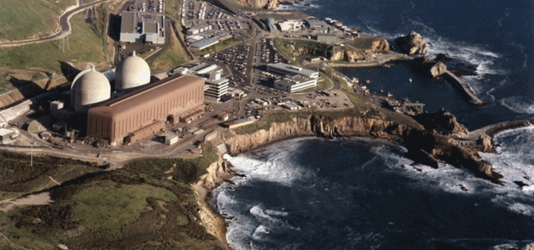 Rapid Nuclear Decommissioning Threatens Climate Targets, Says IEA. Reuters
 has the story: "
Decommissioning
nuclear plants in Europe and North America from 2020 threatens global
plans to cut carbon emissions unless governments build new nuclear
plants or expand the use of renewables, a top International Energy
Agency official said.
Nuclear is now the largest low-carbon power source in Europe and the
United States, about three times bigger than wind and solar combined,
according to IEA data. But most reactors were built in the 1970s and
early 80s, and will reach the end of their life around 2020.
With the average nuclear plant running for 8,000 hours a year versus
1,500-2,000 hours for a solar plant, governments must expand renewable
investments to replace old nuclear plants if they are to meet
decarbonisation targets, IEA Chief Economist Laszlo Varro told Reuters..."
File photo: NRC.
 New Solar Paint Could Offer Endless Supply of Clean Energy.
This is the kind of potential breakthrough we're going to need to power
up world economies without harmful pollution or greenhouse gas
emissions. Fusion reports: "Researchers at RMIT University in Australia
have developed a solar paint that could offer endless supplies of clean
energy. The paint captures water vapor from the surrounding air, and
then uses energy provided by the sunlight to split the water into
hydrogen and oxygen. Once harvested, the resulting hydrogen could power
fuel cells (which can provide electric power) or go directly into
powering combustion engines
New Solar Paint Could Offer Endless Supply of Clean Energy.
This is the kind of potential breakthrough we're going to need to power
up world economies without harmful pollution or greenhouse gas
emissions. Fusion reports: "Researchers at RMIT University in Australia
have developed a solar paint that could offer endless supplies of clean
energy. The paint captures water vapor from the surrounding air, and
then uses energy provided by the sunlight to split the water into
hydrogen and oxygen. Once harvested, the resulting hydrogen could power
fuel cells (which can provide electric power) or go directly into
powering combustion engines..."
Photo credit: Pixabay.
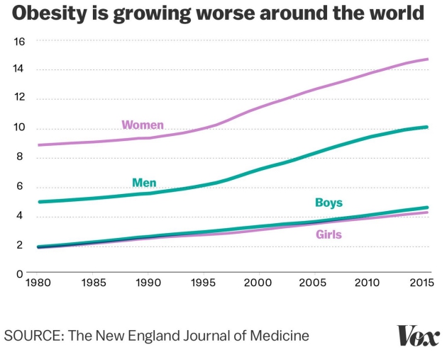
Obesity Now Kills More People Worldwide Than Car Crashes, Terror Attacks and Alzheimer's Combined.
Vox has the discouraging trends: "...
Since
1980, the obesity prevalence has doubled in more than 70 countries
around the world — mainly in low- and middle-income regions — and it has
steadily increased in nearly every other country. The study is the
largest systematic analysis of obesity data ever done, with researchers
combing the medical literature and crunching thousands of data sets on
obesity in adults and children covering 195 countries. Here are their 5
most important takeaways A lack of exercise and too many calories have
been depicted as equal causes of the obesity crisis. But they shouldn’t
be, the NEJM authors said..."
Graphic credit:
Javier Zarracina/Vox.
Stephen Hawking Calls for a Return to the Moon as Earth's Clock Runs Out. So don't sweat the thundershowers! Here's an excerpt from
The Washington Post: "
Humans are overdue for a return trip to the moon, Stephen Hawking has just opined. Speaking on Tuesday at the Starmus Festival,
a science-slash-musical gathering, the astrophysicist offered two parts
doom cut with one part scientific optimism. He argued that we should
prepare for a cosmic exodus to take place in the next 200 to 500 years.
“We are running out of space, and the only place we can go to are other
worlds. It is time to explore other solar systems,” he said via video
link to the audience gathered in Trondheim, Norway. “Spreading out may
be the only thing that saves us from ourselves. I am convinced that
humans need to leave Earth...”
Photo credit: "
Stephen Hawking on a New York stage during the announcement of the Breakthrough Starshot initiative in April 2016." (Lucas Jackson/Reuters).
Alabama Warns of Floating Fire Ants in Flood Waters. Just when you thought it couldn't get much worse comes a story at AP and WMUR.com: "Floating
colonies of fire ants could form in flood waters as Tropical Storm
Cindy trudges inland. That's the warning from Alabama state officials,
who say the insects known as red imported fire ants can present a
potentially serious health threat to people and animals during severe
flooding. The Alabama Cooperative Extension System said in a statement
that the floating colonies may look like ribbons, streamers or a large
ball of ants floating on the water..."

TODAY: Mild sun, PM shower possible. Winds: NW 10-20. High: 71
FRIDAY NIGHT: Patchy clouds - what June? Low: 53
SATURDAY: Morning sun, PM clouds, showers. Winds: NW 10-20. High: 66
SUNDAY: Mostly cloudy, PM shower up north. Winds: NW 10-15. Wake-up: 52. High: 65
MONDAY: Sunny, free A/C continues. Winds: NE 8-13. Wake-up: 50. High: 69
TUESDAY: Sunny and milder. Feels like June. Winds: SE 7-12. Wake-up: 55. High: 79
WEDNESDAY: Humid, heavy showers, T-storms. Winds: SE 10-15. Wake-up: 59. High: 77
THURSDAY: Sunnier, drier - better lake day. Winds: NW 8-13. Wake-up: 62. High: 82
Climate Stories....
 Exxon, BP and Shell Back Carbon Tax Proposal to Cut Emissions.
 Ironic
that the oil majors around the world are coming around and addressing
the elephant in the living room, but the administration is still
advocating ambitious environmental policy right out of the 1950s. Here's
an excerpt from
The Guardian: "
Oil giants ExxonMobil,
Shell, BP and Total are among a group of large corporations supporting a
plan to tax carbon dioxide emissions in order to address climate
change. The companies have revealed their support for the Climate Leadership Council, a group of senior Republican figures that in February proposed a $40 fee on each ton of CO2 emitted
as part of a “free-market, limited government” response to climate
change. The fossil fuel companies announced their backing for the plan
alongside other major firms including Unilever, PepsiCo, General Motors
and Johnson & Johnson..."
Photo credit: "
Under
the proposal, a $40 carbon tax, rising over time, would be levied on
emissions in order to encourage a shift towards renewable energy sources
such as solar and wind." Photograph: Franck Robichon/EPA.


No comments:
Post a Comment