Twin Cities Dew Points So Far This Summer
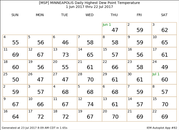
Last
week was certainly a muggy week in the Twin Cities, with maximum dew
points each day in the 60s and 70s. In fact, we saw three days last week
with a dew point of 70 or higher - the highest being both Tuesday and
Wednesday with a max dew point of 72. So far this summer in the Twin
Cities (since June 1st) we have seen 21 days with a dew point of 65 or
higher - seven of those days seeing dew points of 70 or higher. The
highest so far was on the 12th of this month with a dew point of 74. For
comparison, the highest dew point last year in the Twin Cities was 77, with the all-time highest being 82 (which occurred in July of 2011).
_______________________________________________
Comfortable Today - Hot And Sticky By Tuesday
By DJ Kayser, filling in for Douglas
Some like it… muggy?
I know I personally don’t, but muggy weather and summer always go hand in hand. If you are a fan of muggy weather, you certainly enjoyed last week as all but one day saw the dew point at or above 65 at some point during the day. Since June 1st, 21 days have had a dew point at or above 65 in the Twin Cities, and a third of those days have had a 70+ degree dew point. That’s still better than parts of Iowa, which saw dew points in the 80s last Thursday!
Sunday gave us a break from the muggy weather, and that comfortable weather continues today, with highs around 80 and dew points hovering in the 50s. As we head toward the middle of the week, however, sticky weather returns with storms likely. Some of those storms could be strong, with the potential of heavy rain as well. Pleasant weather then returns in the form of Canadian high pressure late in the week.
I'm sure we won't be done with the summer heat and humidity though – we still have August to get through, and the State Fair is only a month away!
_______________________________________________
Extended Twin Cities Forecast
MONDAY: Sunny and comfortable. High 80. Low 66. Chance of precipitation 0%. Wind SE 5-10 mph.
TUESDAY: Muggy. Late day storms. High 91. Low 72. Chance of precipitation 60%. Wind S 5-15 mph.
WEDNESDAY: Storm chance lingers in southern MN. High 83. Low 65. Chance of precipitation 50%. Wind NW 5-15 mph.
THURSDAY: A very pleasant, sunny day. High 82. Low 65. Chance of precipitation 0%. Wind N 5-10 mph.
FRIDAY: Sunny. Nice end to the week. High 83. Low 66. Chance of precipitation 0%. Wind SE 5-10 mph.
SATURDAY: A touch muggier. Mainly sunny skies. High 85. Low 67. Chance of precipitation 20%. Wind SW 5-10 mph.
SUNDAY: Early morning storms. Turning sunny. High 81. Low 58. Chance of precipitation 30%. Wind NW 5-10 mph.
_______________________________________________
This Day in Weather History
July 24th
1987: A historic deluge ends in the Twin Cities. Two-day totals include over a foot of rain at Bloomington. Nearly 10 inches falls in downtown Minneapolis, and near 9 inches is recorded in St. Paul. At one time the water reaches a depth of 13.5 feet on I-494 near East Bush Lake Road. I-494 in Bloomington would be closed for nearly 5 days.
1891: Heavy frost hits Elkton in Mower County in southeast Minnesota. The frost kills all vegetable crops. The low in Elkton is 34, and the Twin Cities have a low of 49.
_______________________________________________
Average Temperatures & Precipitation for Minneapolis
July 24th
Average High: 83F (Record: 104F set in 1936)
Average Low: 64F (Record: 49F set in 1891)
Average Precipitation: 0.14" (Record: 1.69" set in 2012)
________________________________________________
Sunrise/Sunset Times for Minneapolis
July 24th
Sunrise: 5:50 AM
Sunset: 8:48 PM
*Length Of Day: 14 hours, 58 minutes and 24 seconds
*Daylight Lost Since Yesterday: ~2 minute and 5 seconds
*Next Sunrise At/After 6 PM: August 2nd (6:00 AM)
*Next Sunset At/Before 8:30 PM: August 8th (8:29 PM)
________________________________________________
July 24th
1987: A historic deluge ends in the Twin Cities. Two-day totals include over a foot of rain at Bloomington. Nearly 10 inches falls in downtown Minneapolis, and near 9 inches is recorded in St. Paul. At one time the water reaches a depth of 13.5 feet on I-494 near East Bush Lake Road. I-494 in Bloomington would be closed for nearly 5 days.
1891: Heavy frost hits Elkton in Mower County in southeast Minnesota. The frost kills all vegetable crops. The low in Elkton is 34, and the Twin Cities have a low of 49.
_______________________________________________
Average Temperatures & Precipitation for Minneapolis
July 24th
Average High: 83F (Record: 104F set in 1936)
Average Low: 64F (Record: 49F set in 1891)
Average Precipitation: 0.14" (Record: 1.69" set in 2012)
________________________________________________
Sunrise/Sunset Times for Minneapolis
July 24th
Sunrise: 5:50 AM
Sunset: 8:48 PM
*Length Of Day: 14 hours, 58 minutes and 24 seconds
*Daylight Lost Since Yesterday: ~2 minute and 5 seconds
*Next Sunrise At/After 6 PM: August 2nd (6:00 AM)
*Next Sunset At/Before 8:30 PM: August 8th (8:29 PM)
________________________________________________
Minnesota Weather Outlook
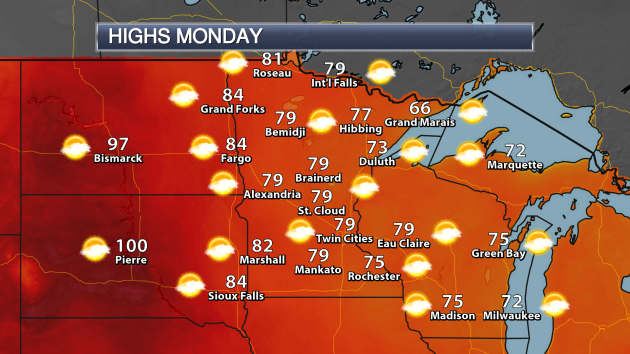 Another
nice day is expected across the state Monday, with highs in the 70s in
most spots. Areas along Lake Superior will likely stay in the 60s, with
areas of western Minnesota reaching the low 80s. The hot weather will
stay out in the Dakotas, where Pierre is likely to top 100.
Another
nice day is expected across the state Monday, with highs in the 70s in
most spots. Areas along Lake Superior will likely stay in the 60s, with
areas of western Minnesota reaching the low 80s. The hot weather will
stay out in the Dakotas, where Pierre is likely to top 100.
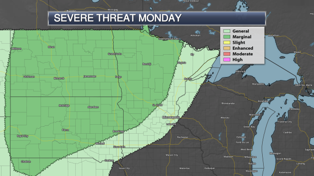 As
we head toward the overnight hours, however, storms are expected to
form across the Dakotas and eventually move into parts of western
Minnesota. These stronger storms may be capable of damaging winds.
As
we head toward the overnight hours, however, storms are expected to
form across the Dakotas and eventually move into parts of western
Minnesota. These stronger storms may be capable of damaging winds.
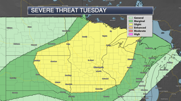 A
severe risk will exist on Tuesday as well as the cold front moves
through the upper Midwest. The greatest risk will be during the
overnight hours across the region with damaging winds. However, hail and
tornadoes will be possible, especially if any storms pop during the
afternoon and evening.
A
severe risk will exist on Tuesday as well as the cold front moves
through the upper Midwest. The greatest risk will be during the
overnight hours across the region with damaging winds. However, hail and
tornadoes will be possible, especially if any storms pop during the
afternoon and evening.
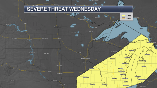 Isolated
severe storms will continue to be possible across southeast Minnesota
Wednesday as the cold front continues to move through.
Isolated
severe storms will continue to be possible across southeast Minnesota
Wednesday as the cold front continues to move through.
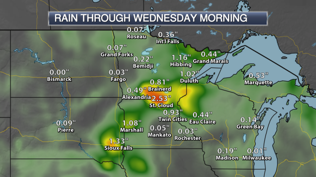 Heavy
rain will be possible with these storms as well. The models are showing
some of heaviest will be possible across southwest and central
Minnesota, with the potential of over 2" in St. Cloud.
Heavy
rain will be possible with these storms as well. The models are showing
some of heaviest will be possible across southwest and central
Minnesota, with the potential of over 2" in St. Cloud.
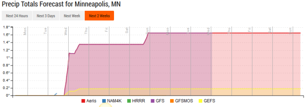 After
the rain expected toward the middle of the week, the next rain chance
will move in Saturday Night as a cold front sweeps through the state.
After that, modes indicate drier weather through the first week of
August.
After
the rain expected toward the middle of the week, the next rain chance
will move in Saturday Night as a cold front sweeps through the state.
After that, modes indicate drier weather through the first week of
August.
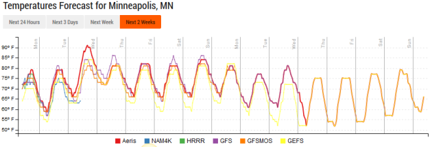 The
warmest weather over the next couple weeks appears to be Tuesday, when
temperatures will be pushing 90 in the Twin Cities. Otherwise, models
are showing highs at or below average into the beginning of next month.
The
warmest weather over the next couple weeks appears to be Tuesday, when
temperatures will be pushing 90 in the Twin Cities. Otherwise, models
are showing highs at or below average into the beginning of next month.
_______________________________________________
National Weather Outlook
Monday Forecast
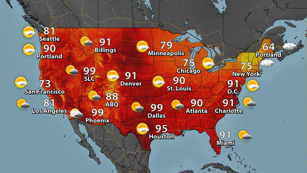 Finally
the heat is starting to break across portions of the central U.S. as we
head into Monday (at least for a day) as temperatures will only be
around 90 in St. Louis. Monsoonal storms will continue to be possible
across parts of the Southwest, meanwhile a frontal system brings the
chance of storms from the Northeast to the southern Plains.
Finally
the heat is starting to break across portions of the central U.S. as we
head into Monday (at least for a day) as temperatures will only be
around 90 in St. Louis. Monsoonal storms will continue to be possible
across parts of the Southwest, meanwhile a frontal system brings the
chance of storms from the Northeast to the southern Plains.
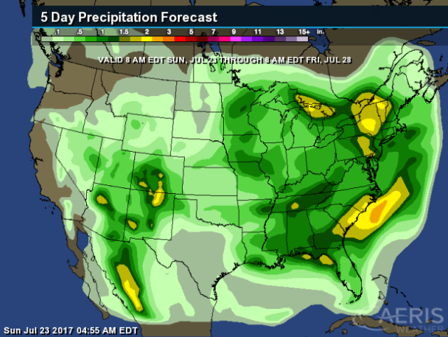 The
heaviest rain through Friday will be in the eastern U.S., where some
areas from New York to the Carolina coasts could pick up two inches or
more of rain. Heavy rain will also be possible in parts of the Southwest
thanks to monsoonal storms.
The
heaviest rain through Friday will be in the eastern U.S., where some
areas from New York to the Carolina coasts could pick up two inches or
more of rain. Heavy rain will also be possible in parts of the Southwest
thanks to monsoonal storms.
_______________________________________________
_______________________________________________
National Weather Outlook
Monday Forecast
_______________________________________________
How Often Do 80+ Dew Points Occur?
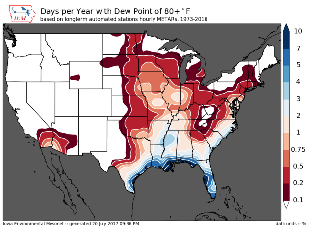
Last
week parts of Iowa reached the 80s for dew points. How common is that
around the nation? As you can see from this map from the Iowa
Environmental Mesonet, the most common areas to see them is around the
Gulf Coast, but areas into the upper Midwest do tend to see some each
year. Click to read more from IEM.
The Total Solar Eclipse Is Coming!
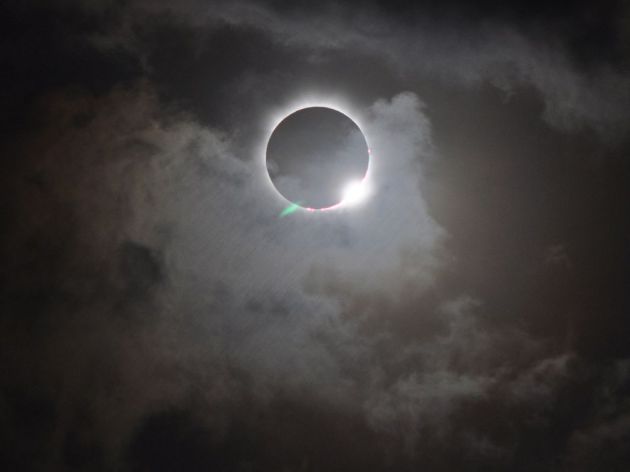
We
are now less than a month away from the total solar eclipse, and more
anticipation is being built up for it. Have you ever looked at the path
of the peak of the eclipse and wondered why it moves west to east? Popular Science has the answer why that is: "This
summer, for the first time since 1918, a total solar eclipse will cut a
path across the mainland United States. On August 21, everyone in North
America will be able to watch the moon pass in front of the sun,
blotting out some or all of its light (depending on where you live).
People near Lincoln City, Oregon will see the total eclipse around
9:05am PDT. Then the path of totality slants eastward, finishing up in
South Carolina at 2:43pm EDT. But hold on—if the moon rises in the east
and sets in the west (or pretty close to it, anyway), why does the
shadow of an eclipse move from west to east? The answer, says Angela
Speck, an astronomer at the University of Missouri, is a matter of
perspective." (Image above: A total solar eclipse in Australia. NASA.)
Meanwhile,
WIRED did the math to try and figure out how many people could actually
watch the total solar eclipse in August. I won't spoil the amount - you'll just have to click and find out yourself!
A New Gold Rush In California
There's
gold in the rivers! Well, some rivers... and it's all due to that
Oroville Dam that was damaged back in February due to heavy rain. LiveScience has more: "The
Oroville Spillway emergency in California may have one silver — or gold
— lining: The debris kicked up by weeks of heavy rain and runoff is now
flecked with gold, and amateur gold panners are enjoying quite the
bonanza. The "gold rush" is occurring along the Feather and Yuba rivers,
which are fed by the Oroville Dam. Of course, would-be panners should
take note: It's unlikely that panners will hit the jackpot and retire
with steamer trunks full of gold bars; the average haul from panning the
river lately is worth just $40 to $300, CBS5 reported."
Tectonic Activity... And Life

You
may not think of the two being connected, but a new theory out from
scientists says that tectonic activity may actually be needed for life
to exist. More from Scientific American: "Our
planet is in constant flux. Tectonic plates—the large slabs of rock
that divide Earth’s crust so that it looks like a cracked
eggshell—jostle about in fits and starts that continuously reshape our
planet—and possibly foster life. These plates ram into one another,
building mountains. They slide apart, giving birth to new oceans that
can grow for hundreds of millions of years. They skim past one another,
triggering earth-shattering quakes. And they slip under one another in a
process called subduction, sliding deep into the planet’s innards and
producing volcanoes that spew gases into the atmosphere. And not only is
Earth alive, it is a vessel for life. Because it is the only known
planet to host both plate tectonics—that ongoing shuffling of tectonic
plates—and life, many scientists think the two might be related. In
fact, some researchers argue that shifting plates, which have the
ability to help regulate a planet’s temperature over billions of years,
are a crucial ingredient for life." (Image: This artist’s conception shows 55 Cancri e—a world that might be overrun by flowing lava. Credit: ESA / Hubble, M. Kornmesser)
______________________________
Thanks for checking in and have a great Monday! Don't forget to follow me on Twitter (@dkayserwx) and like me on Facebook (Meteorologist D.J. Kayser)!
- D.J. Kayser

No comments:
Post a Comment