14 Fun Facts About Dragonflies...
I was poking around in the garden this weekend and my 5-year old son came up to me holding this beautiful dragonfly. It didn't move much, made me wonder if he was tired from breakfast. It got me thinking, what to dragonflies even eat? It turns out they help control the mosquito population and can eat as many as 30 to 100 mosquitoes a day! WOW!! Here's an excerpt from SmithsonianMag.com HERE:
Flying insects are usually annoying. Mosquitoes bite you, leaving itchy red welts. Bees and wasps sting. Flies are just disgusting. But there’s something magical about dragonflies.
1 ) Dragonflies were some of the first winged insects to evolve, some 300 million years ago. Modern dragonflies have wingspans of only two to five inches, but fossil dragonflies have been found with wingspans of up to two feet.
2 ) Some scientists theorize that high oxygen levels during the Paleozoic era allowed dragonflies to grow to monster size.
3 ) There are more than 5,000 known species of dragonflies, all of which (along with damselflies) belong to the order Odonata, which means “toothed one” in Greek and refers to the dragonfly’s serrated teeth.
4 ) In their larval stage, which can last up to two years, dragonflies are aquatic and eat just about anything—tadpoles, mosquitoes, fish, other insect larvae and even each other.
5 ) At the end of its larval stage, the dragonfly crawls out of the water, then its exoskeleton cracks open and releases the insect’s abdomen, which had been packed in like a telescope. Its four wings come out, and they dry and harden over the next several hours to days.
6 ) Dragonflies are expert fliers. They can fly straight up and down, hover like a helicopter and even mate mid-air. If they can’t fly, they’ll starve because they only eat prey they catch while flying.
7 ) Dragonflies catch their insect prey by grabbing it with their feet. They’re so efficient in their hunting that, in one Harvard University study, the dragonflies caught 90 to 95 percent of the prey released into their enclosure.
8 ) The flight of the dragonfly is so special that it has inspired engineers who dream of making robots that fly like dragonflies.
9 ) Some adult dragonflies live for only a few weeks while others live up to a year.
10 ) Nearly all of the dragonfly’s head is eye, so they have incredible vision that encompasses almost every angle except right behind them.
11 ) Dragonflies, which eat insects as adults, are a great control on the mosquito population. A single dragonfly can eat 30 to hundreds of mosquitoes per day.
12 ) Hundreds of dragonflies of different species will gather in swarms, either for feeding or migration. Little is known about this behavior, but the Dragonfly Swarm Project is collecting reports on swarms to better understand the behavior. (Report a swarm here.)
13 ) Scientists have tracked migratory dragonflies by attaching tiny transmitters to wings with a combination of eyelash adhesive and superglue. They found that green darners from New Jersey traveled only every third day and an average of 7.5 miles per day (though one dragonfly traveled 100 miles in a single day).
14 ) A dragonfly called the globe skinner has the longest migration of any insect—11,000 miles back and forth across the Indian Ocean.

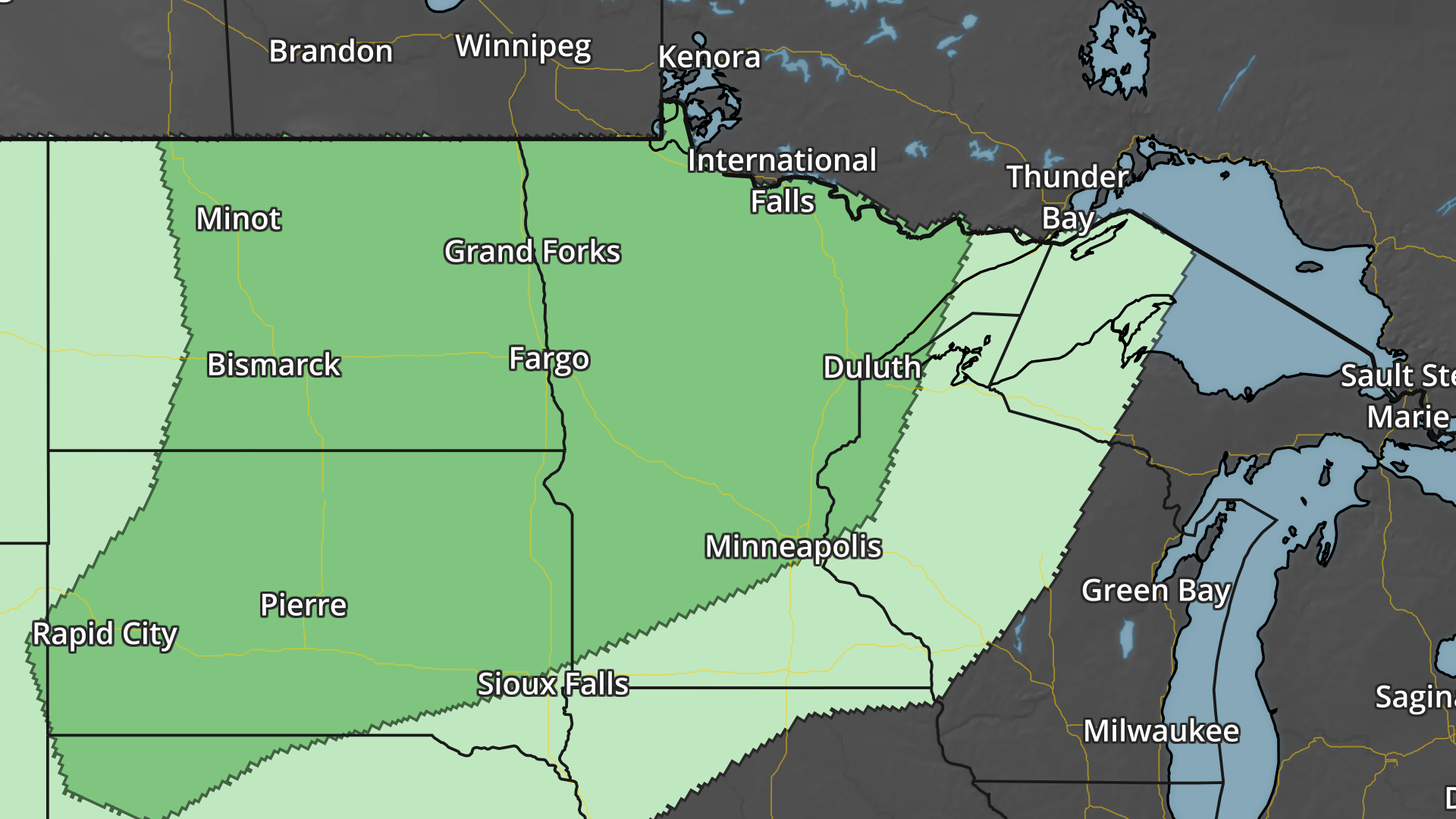
Severe Threats: Monday, Tuesday & Wednesday
According to NOAA's SPC, there is a risk of strong to severe storms as we head into next week. At this point, there is a MARGINAL risk for severe storms late in the Monday across much of Minnesota, while Tuesday there is another threat across the much of the state. By Wednesday, the threat shifts farther east.
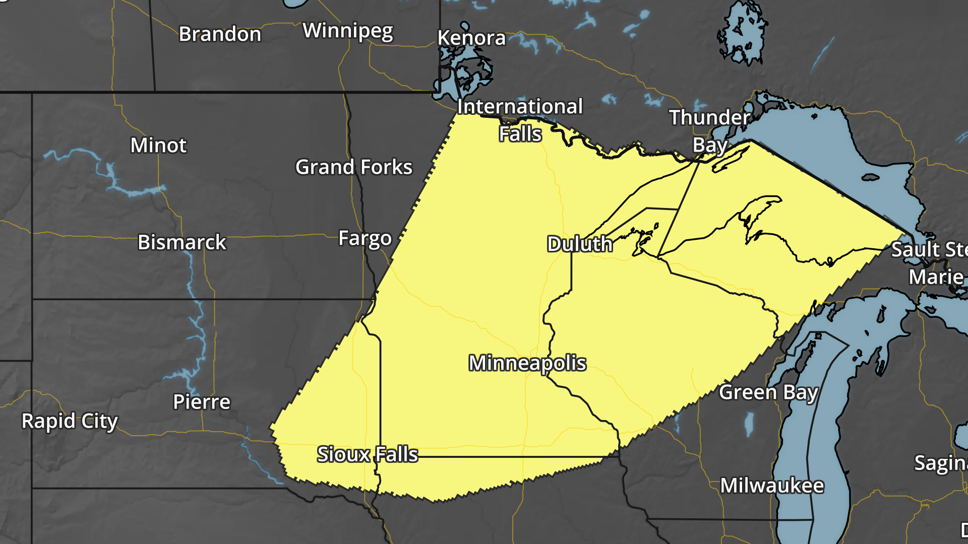
Simulated Radar
The simulated radar from midday midday Sunday to Wednesday shows a fairly active start to the week. It appears the first round of potentially strong to severe storms with locally heavy rainfall would arrive late Monday into Tuesday before skirting south of the region Wednesday.
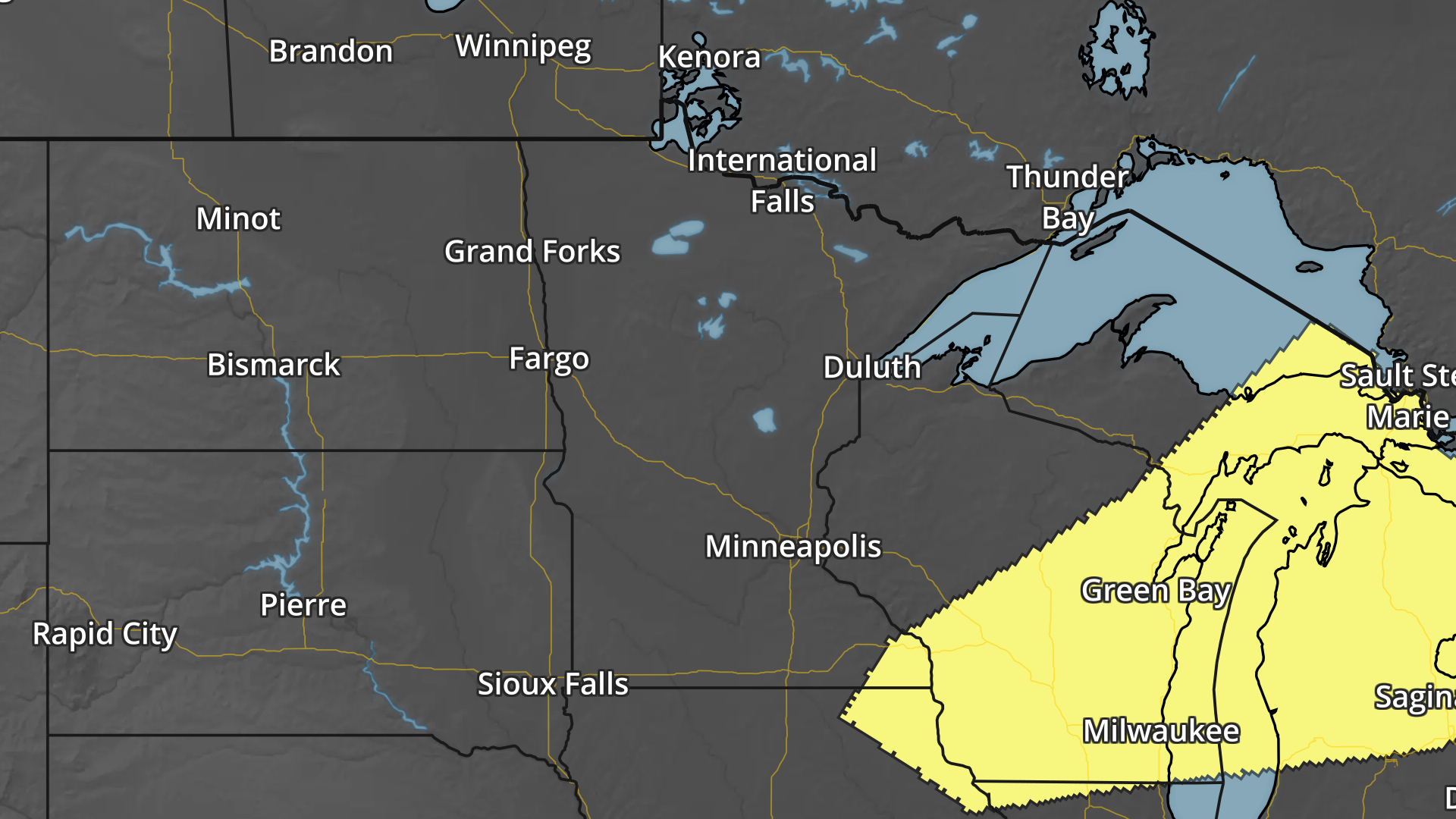
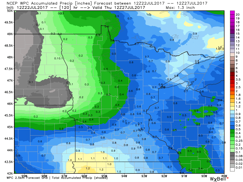
Heavy Rainfall Potential Ahead
The rainfall forecast through AM Thursday shows pockets of heavier rain across the Arrowhead and southern Minnesota. Some locations could see nearly 1" over the next few days as our storm threat moves through this week.
___________________________________________________________________________
GREG in the Eastern Pacific
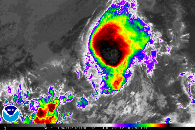
The National Hurricane Center continues to track GREG, which as of early Saturday was a tropical storm with sustained winds of 50mph. GREG is the 7th named storm of the 2017 Eastern Pacific Hurricane Season. There have been 3 hurricanes this season, 1 of which was a major hurricane (FERNANDA) that reached category 4 strength. The IR satellite loop below shows a big blob of thunderstorms, but nothing really well-defined.
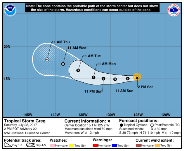
Here's the official track for GREG, which has it staying a tropical storm through next week. The good news is that this storm will continue to drift west, away from any major land masses.
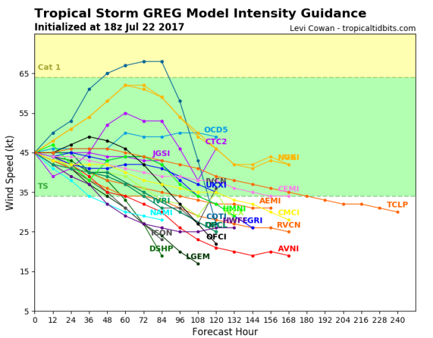
Greg Strength
Most of the forecast models for GREG keep this storm at tropical storm status, but one brings it close to hurricane strength as we head into the next couple/few days.
Eastern Pacific Outlook: Next 5 Days
Weather conditions in the Eastern Pacific continue to remain active as NOAA's NHC is keeping an eye on 2 other waves of energy east of GREG one has become Tropical Depression NINE while the other one has become Tropical Depresison TEN.
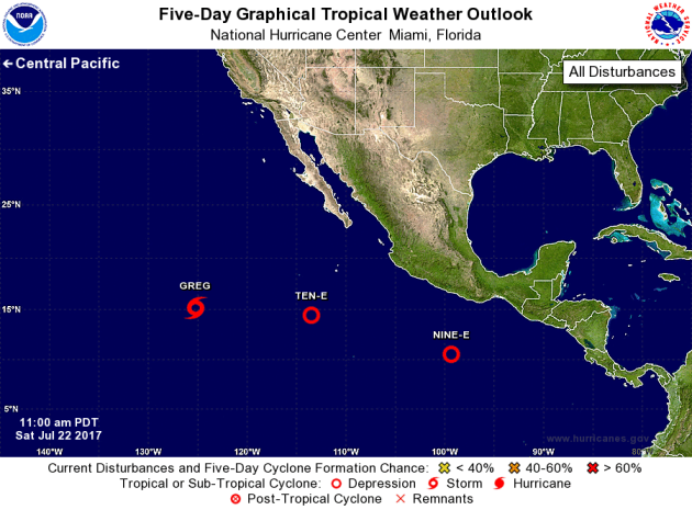
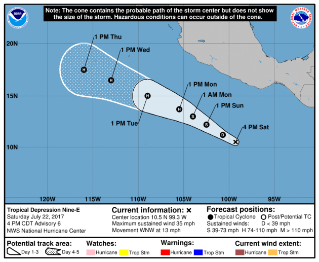
Tropical Depression NINE
According to NOAA's NHC, this particular storm could become a tropical storm over the weekend and potentially even become our 4th hurricane of the season by Tuesday. This storm is forecast to track a little closer to Mexico, which will help to bring higher surf along the west coast of Mexico.
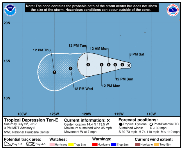
Tropical Depression TEN
This storm also has the potential to become a tropical storm as we head through the weekend, but turning into a tropical storm prior to NINE. The other difference is that this storm is not expected to turn into a hurricane.
Atlantic Outlook: Next 5 Days
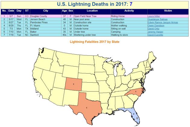
2017 Lightning Fatalities
According to NOAA's NWS, there have been 7 lightning fatalities so far this year, the most recent coming from North Carolina on July 18th as a 40-some year old man was walking to store. Note that 4 of these deaths have occurred in Florida, which is considered to be the lightning capital of the United States.
 Lightning Deaths Over the Last 10 Years
According to NOAA's NWS, lightning kills an average of 47 people each year in United States! Over the last 10 years, 310 people have died from lightning and what is interesting is that nearly 79% have been males!
Lightning Deaths Over the Last 10 Years
According to NOAA's NWS, lightning kills an average of 47 people each year in United States! Over the last 10 years, 310 people have died from lightning and what is interesting is that nearly 79% have been males!
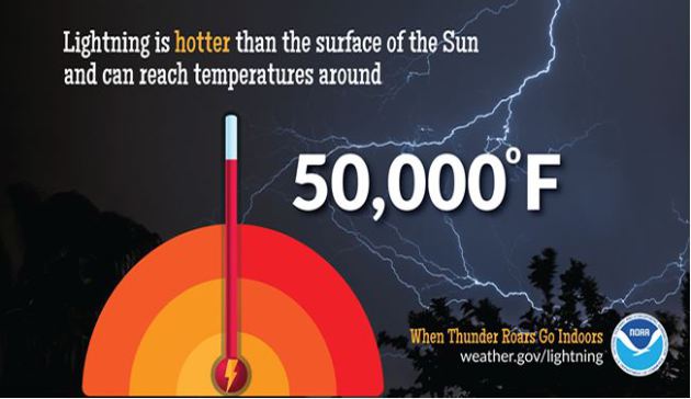
.png) Lightning Safety: Myths & Facts
Did you know that lightning is nearly 5 times hotter than the surface of the sun? Here are a few interesting myths and facts from NOAA's NWS regarding lightning:
Lightning Safety: Myths & Facts
Did you know that lightning is nearly 5 times hotter than the surface of the sun? Here are a few interesting myths and facts from NOAA's NWS regarding lightning:
Myth: If you're caught outside during a thunderstorm, you should crouch down to reduce your risk of being struck.
Fact: Crouching doesn't make you any safer outdoors. Run to a substantial building or hard topped vehicle. If you are too far to run to one of these options, you have no good alternative. You are NOT safe anywhere outdoors. See our safety page for tips that may slightly reduce your risk.
Myth: Lightning never strikes the same place twice.
Fact: Lightning often strikes the same place repeatedly, especially if it's a tall, pointy, isolated object. The Empire State Building is hit an average of 23 times a year
Myth: If it’s not raining or there aren’t clouds overhead, you’re safe from lightning.
Fact: Lightning often strikes more than three miles from the center of the thunderstorm, far outside the rain or thunderstorm cloud. “Bolts from the blue” can strike 10-15 miles from the thunderstorm.
Myth: Rubber tires on a car protect you from lightning by insulating you from the ground.
Fact: Most cars are safe from lightning, but it is the metal roof and metal sides that protect you, NOT the rubber tires. Remember, convertibles, motorcycles, bicycles, open-shelled outdoor recreational vehicles and cars with fiberglass shells offer no protection from lightning. When lightning strikes a vehicle, it goes through the metal frame into the ground. Don't lean on doors during a thunderstorm.
Myth: A lightning victim is electrified. If you touch them, you’ll be electrocuted.
Fact: The human body does not store electricity. It is perfectly safe to touch a lightning victim to give them first aid. This is the most chilling of lightning Myths. Imagine if someone died because people were afraid to give CPR!
Myth: If outside in a thunderstorm, you should seek shelter under a tree to stay dry.
Fact: Being underneath a tree is the second leading cause of lightning casualties. Better to get wet than fried!
See more on lightning including safety tips HERE:
 ___________________________________________________________________________
National Weather Hazards Ahead...
According to NOAA's NWS, there have been 7 lightning fatalities so far this year, the most recent coming from North Carolina on July 18th as a 40-some year old man was walking to store. Note that 4 of these deaths have occurred in Florida, which is considered to be the lightning capital of the United States.
Myth: If you're caught outside during a thunderstorm, you should crouch down to reduce your risk of being struck.
Fact: Crouching doesn't make you any safer outdoors. Run to a substantial building or hard topped vehicle. If you are too far to run to one of these options, you have no good alternative. You are NOT safe anywhere outdoors. See our safety page for tips that may slightly reduce your risk.
Myth: Lightning never strikes the same place twice.
Fact: Lightning often strikes the same place repeatedly, especially if it's a tall, pointy, isolated object. The Empire State Building is hit an average of 23 times a year
Myth: If it’s not raining or there aren’t clouds overhead, you’re safe from lightning.
Fact: Lightning often strikes more than three miles from the center of the thunderstorm, far outside the rain or thunderstorm cloud. “Bolts from the blue” can strike 10-15 miles from the thunderstorm.
Myth: Rubber tires on a car protect you from lightning by insulating you from the ground.
Fact: Most cars are safe from lightning, but it is the metal roof and metal sides that protect you, NOT the rubber tires. Remember, convertibles, motorcycles, bicycles, open-shelled outdoor recreational vehicles and cars with fiberglass shells offer no protection from lightning. When lightning strikes a vehicle, it goes through the metal frame into the ground. Don't lean on doors during a thunderstorm.
Myth: A lightning victim is electrified. If you touch them, you’ll be electrocuted.
Fact: The human body does not store electricity. It is perfectly safe to touch a lightning victim to give them first aid. This is the most chilling of lightning Myths. Imagine if someone died because people were afraid to give CPR!
Myth: If outside in a thunderstorm, you should seek shelter under a tree to stay dry.
Fact: Being underneath a tree is the second leading cause of lightning casualties. Better to get wet than fried!
See more on lightning including safety tips HERE:
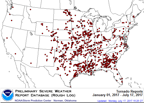
PRELIMINARY 2017 Tornado Map
It certainly has been a fairly active first half of 2017 with 1187 preliminary tornado reports through July 21st. Note that this is the most tornadoes through July 11th since 2011, when there were 1,655 reports. The map below shows the distribution of the tornadoes so far this year.
 PRELIMINARY 2017 Tornado Count
According to NOAA's SPC, the PRELIMINARY 2017 tornado count is 1187 (through July 21). Note that is the most active year for tornadoes since 2011, when there were 1,655 tornadoes. Keep in mind there was a major tornado outbreak in the Gulf Coast region from April 25-28, 2011 that spawned nearly 500 tornadoes, some of which were deadly. That outbreak is known as the Super Outbreak of 2011 and has gone down in history as one of the biggest, costliest and one of the deadliest tornado outbreaks in history.
.png)
____________________________________________________________
According to NOAA's SPC, the PRELIMINARY 2017 tornado count is 1187 (through July 21). Note that is the most active year for tornadoes since 2011, when there were 1,655 tornadoes. Keep in mind there was a major tornado outbreak in the Gulf Coast region from April 25-28, 2011 that spawned nearly 500 tornadoes, some of which were deadly. That outbreak is known as the Super Outbreak of 2011 and has gone down in history as one of the biggest, costliest and one of the deadliest tornado outbreaks in history.
____________________________________________________________
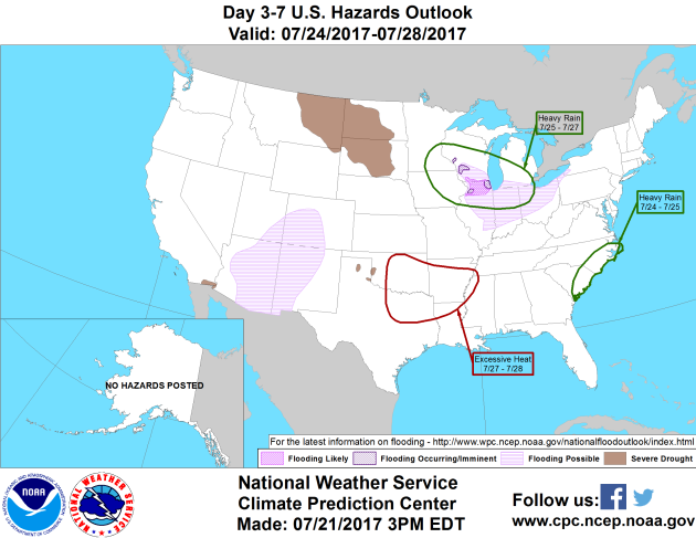
2.) Heavy rain shifting southeast across the upper to middle Mississippi Valley, Great Lakes, and Midwest, Tue-Thu, Jul 25-27.
3.) Flash flooding possible for parts of Arizona, Colorado, New Mexico, and Utah, Mon-Fri, Jul 24-28.
4.) Excessive heat for parts of the lower Mississippi Valley, Oklahoma, and Texas, Thu-Fri, Jul 27-28.
5.) Excessive heat continuing for parts of Oklahoma and Texas, Sat-Mon, Jul 29-31.
6.) Flash flooding possible for the desert Southwest, Sat-Fri, Jul 29-Aug 4.
7.) Slight risk of much above-normal temperatures for much of the western U.S. and Great Plains, Sat-Fri, Jul 29-Aug 4.
8.) Flooding occurring, imminent, or possible for parts of the upper Mississippi Valley, Great Lakes, and Midwest.
9.) Severe Drought across parts of the Great Plains, Arizona, California, and Hawaii.
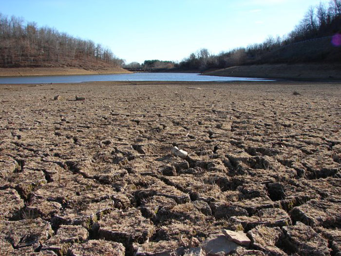
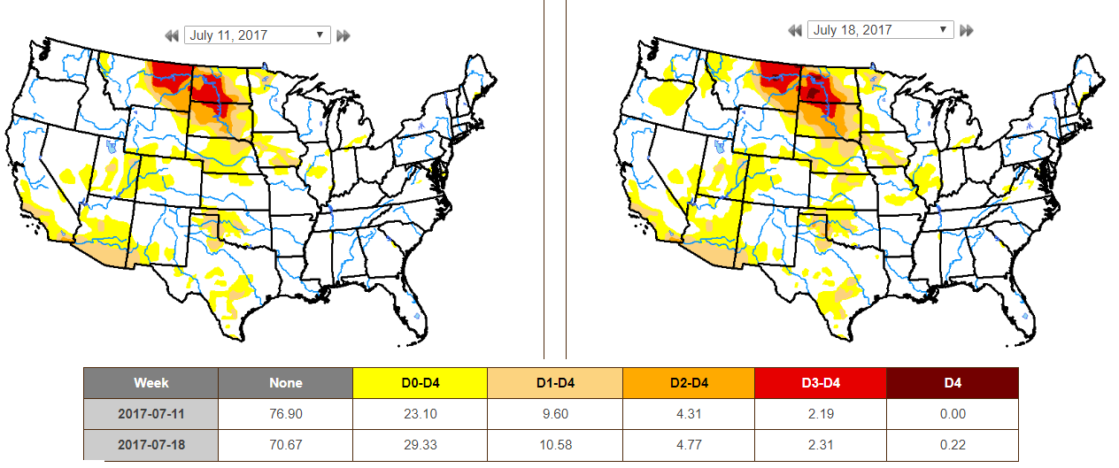
Six percent of North Dakota is now experiencing exceptional drought, according to the U.S. Drought Monitor, which was updated Thursday. It is the first time since 2006 that the state has been put in a D4 drought rating. The Drought Monitor also shows 34 percent of the state is in extreme drought (D3), 17 percent in severe drought (D2) and 17 percent in moderate drought (D1). Seventy-four percent of the state is experiencing some level of drought, two percentage points higher than last week. Meanwhile, more drought resources have been shaking loose for midwestern farmers and ranchers affected by the worsening conditions in primarily Montana, North Dakota and South Dakota.
See more from WillistonHerald.com HERE:
 ___________________________________________________________________________
See more from WillistonHerald.com HERE:
___________________________________________________________________________
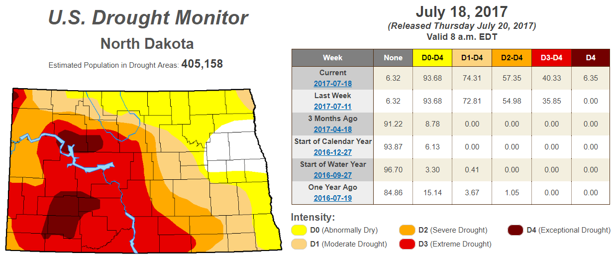
EXCEPTIONAL Drought in North Dakota
According to the US Drought Monitor, parts of North Dakota are now under an EXCEPTIONAL Drought. Interestingly, this is the first time since 2006! While a little more than 6% is considered to be in an EXCEPTIONAL drought, more than 40% is under an EXTREME drought, which is up from the nearly 36% last week. Also, nearly 94% of the state is considered to be either abnormally dry or in some type of drought.
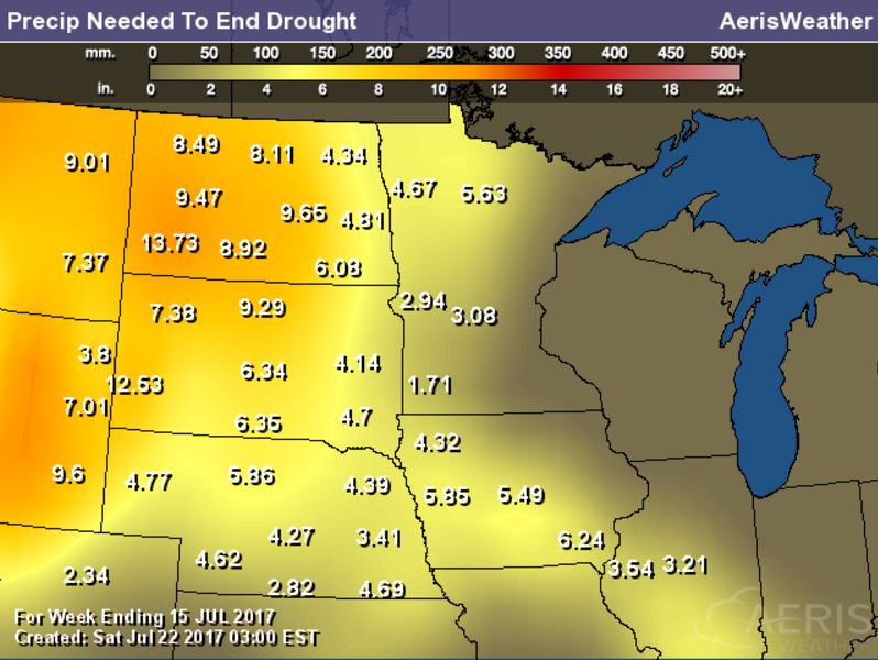
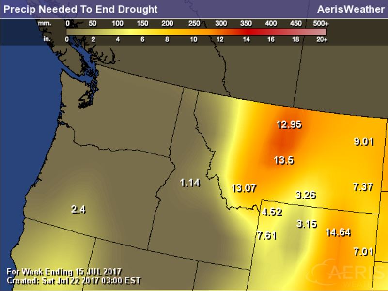
Rain Needed to End Drought
Exceptional and Extreme drought conditions are in place over parts of Montana and North and South Dakota due to several days/week of hot and dry weather. The image below suggests how much rain would be needed to end the drought, which suggests nearly 6" to 12" or more!
US Drought Monitor
According to the US Drought Monitor, drought conditions from July 11h to July 18th worsened slightly across the nation. Note that EXCEPTIONAL and EXTREME drought conditions (located across parts of Montana and parts of North and South Dakota increased from last week
_________________________________________________________________________
National Weather Outlook
Here's the weather outlook through the middle next week, which shows stormier weather starting to develop across the northern tier of the nation once again. Some of these storms could be strong to severe with areas of heavy rainfall, which could lead to localized flooding. There will also be a continued monsoon storm threat across the Desert Southwest through the week with the potential of damaging winds, dust storms and localized flooding.

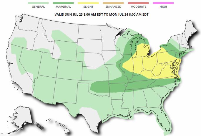
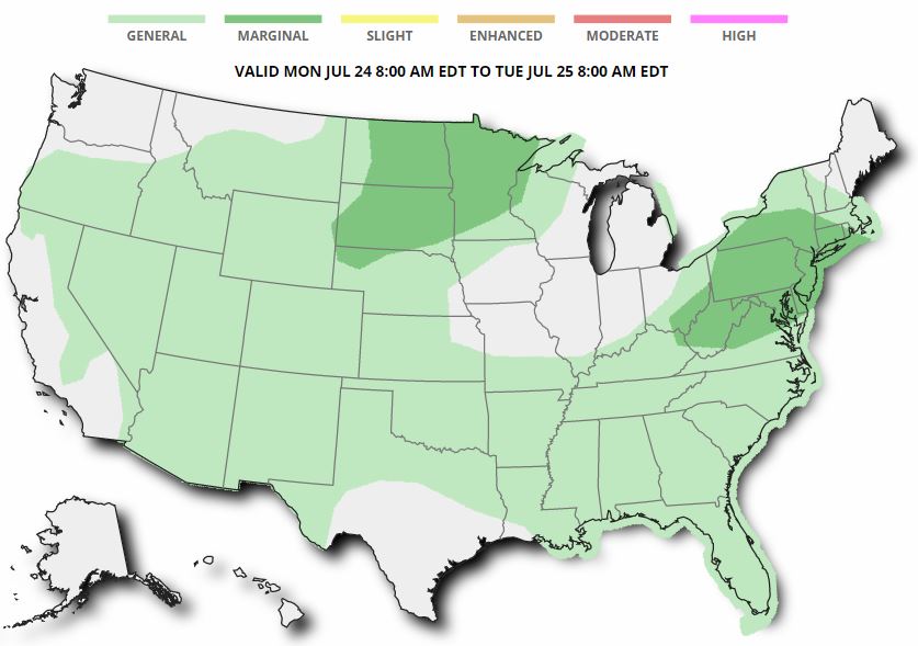
Severe Threats Sunday & Monday
Here are the severe weather concerns for Sunday & Monday, which shows the best potential of strong to severe storms parts of the Ohio Valley and Great Lakes into parts of the Northeast and Mid-Atlantic State on Sunday. The severe threat continues across parts of the Northeast on Monday, but also moves back into the Upper Midwest.
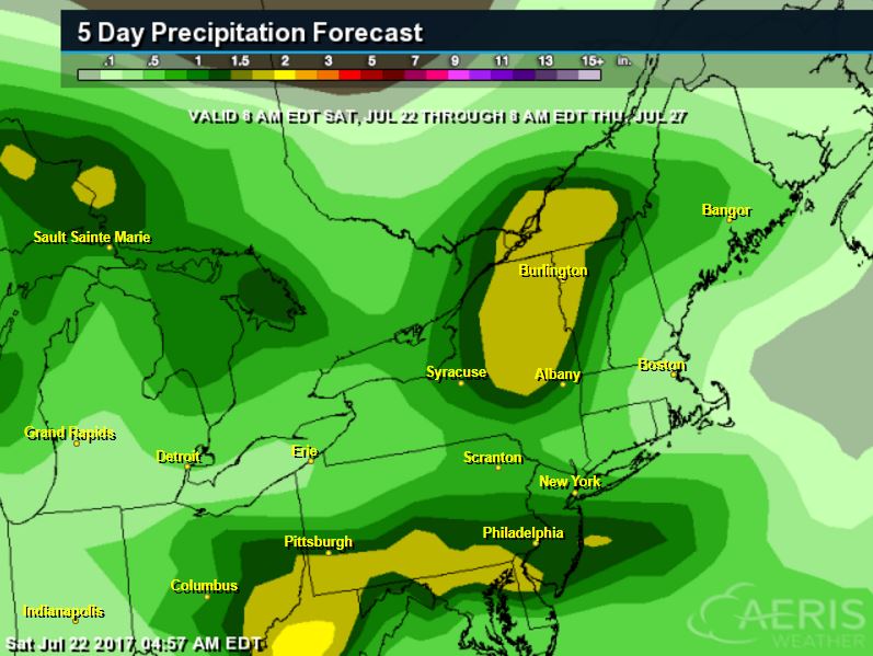
Excessive Rainfall Potential Sunday & Monday
According to NOAA's WPC, there is a risk of excessive rain on Sunday across parts of the Central and Eastern US especially across West Virginia, but the best chance is located across the Desert Southwest. On Monday, the heavy rainfall threat continues across parts of the Northeast and the Desert Southwest.
.gif)
.gif)
Localized Heavy Rain Threats
Excessive rainfall potential is in place over parts of the Northeast over the next couple/few days and the rainfall forecast suggests some 1" to 2"+ rainfall tallies through AM Thursday. Areas of heavy rain could lead to localized areas of flooding.
________________________________________________________
Monsoonal Storms
WOW - take a look at this video that @WesCallisonTNN tweeted a couple of days ago, which shows a montoon storm developing and dumping a huge blob of heavy rain over some of the mountains in Arizona. These types of heavy rainfall events can lead to dust storms and flash flooding.

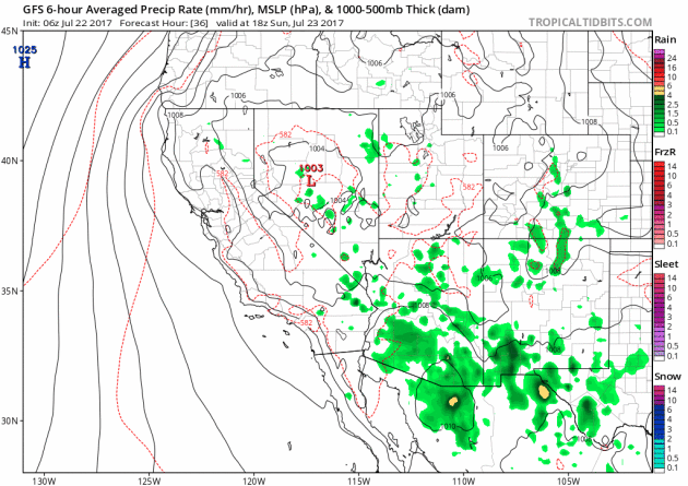
Monsoon Storms Continue
Here's the simulated radar from Sunday to Thursday, which shows the potential of daily monsoon storms continuing across the region. Note that some of the storms could be a little on the strong side with gusty winds, dust storms and locally heavy rain, which could lead to localized flooding. The 5 day rainfall forecast below suggests that some areas could see up to 1" of rain or more through the end of next week!
 ________________________________________________________________________
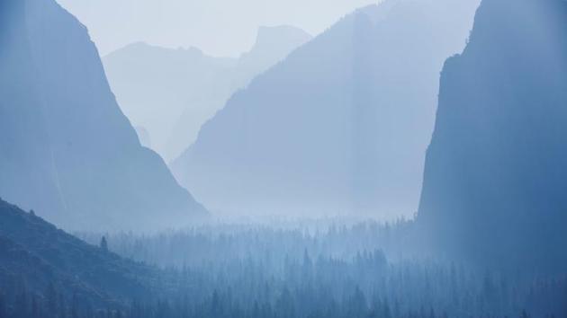
"Smoke from Mariposa fire obscures vistas in Yosemite National Park"
"Smoke was taking a visible toll Saturday on Yosemite National Park, where some of the most picturesque vistas on earth were hidden behind eerie curtains of thick haze drifting in from the devastating Detwiler fire, about 35 miles to the west. From the famous Tunnel View overlook on Highway 41, granite monoliths towering over Yosemite Valley including El Capitan and Half Dome resembled gray silhouettes. Bridal Veil Falls was barely visible. Earlier in the week, these formations, along with waterfalls gushing with unusually heavy runoff from this winter’s historic snowpack, could not be seen at all through the gray shroud."
(Smoke from the Detwiler fire blankets the entire Yosemite Valley, as seen from the Tunnel View in Yosemite National Park. (Marcus Yam / Los Angeles Times))
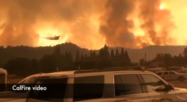
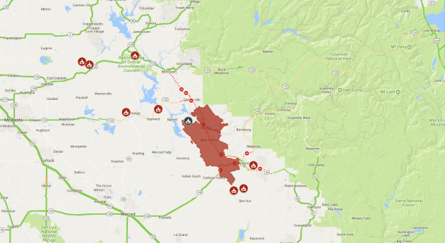
DetWiler Fire - Near Yosemite - California
The Detwiler Fire located near Yosemite National Park in California has ballooned to a very large 75,200 acre fire since Sunday, July 16th. This fire has already consumed more than 120 structures; 60 homes, 63 minor structures and 1 commercial structure. A number of other homes and smaller structures have been damaged as well, but 1,500 other structures are being threatened now. There are almost 4,500 people working on the fire and it is only 30% contained at this point . Gusty winds will continue to keep this fire threat high.
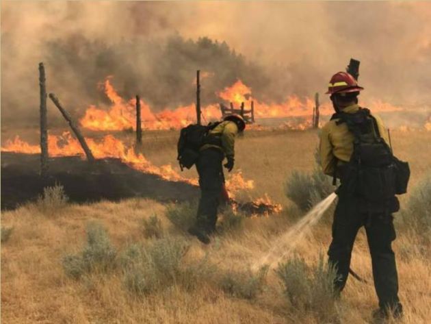
Lodgepole Complex - Montana
According to Inciweb, one of the largest fires currently burning in the Lower 48 is the Lodgepole Complex located 52 miles NW of Jordan, MT. This particular fire has consumed a whopping 125,000 acres and is expected to be fully contained by Wednesday, August 2nd. This particular fire started on Wednesday, July 19th and quickly spread as hot, dry and windy weather created extreme fire behavior. Gusty winds are still posing a concern for the fire.
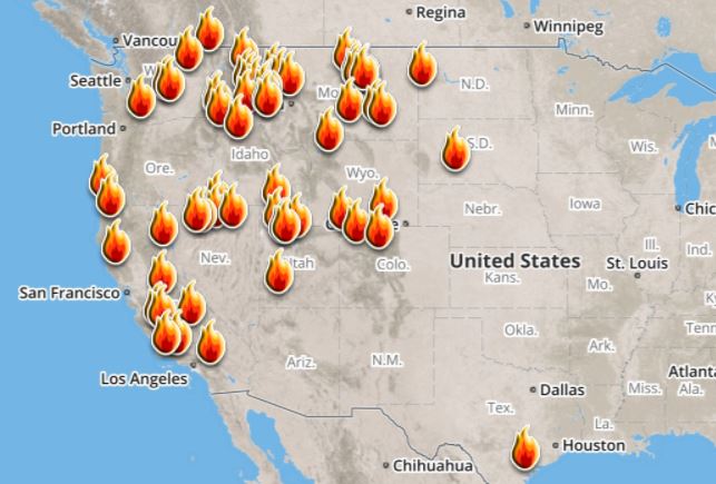
Ongoing Large Wildfires
Here's a look at the current wildfire map across the country. Recent hot and dry weather has helped to spark several wildfires across the Western US, while a few have also been popping up in the Eastern US.
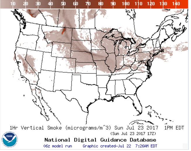
National Smoke Analysis
Here's the projected wildfire smoke concentration for midday Sunday, which suggests that smoke from wildfires burning across parts of Canada and the Western US could continue to linger around the Upper Midwest/Great Lakes region. There also appears a very high concentration of smoke from fires burning across the western half of Canada. If you are in these areas, air quality could be a little poor, but these areas may also be enjoying very interesting looking sunrises/sunsets, which tend to look hazy or reddish-orange.
________________________________________________________________________
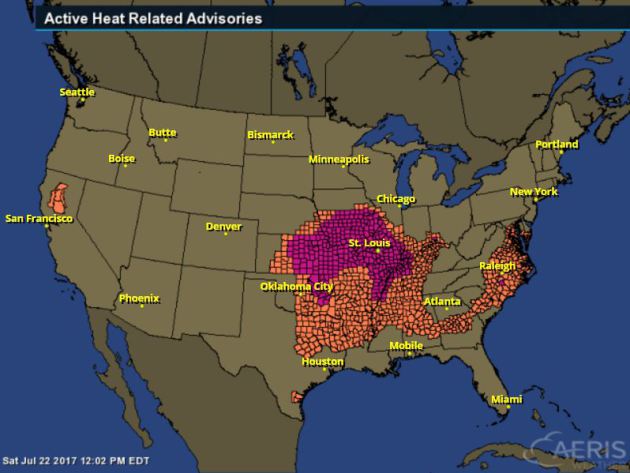
Excessive Heat Concerns
Excessive Heat Warning and Advisories continue across many locations in the Central and Eastern US through the weekend. Dangerous heat index values of 100F to 115F may be possible in these areas.
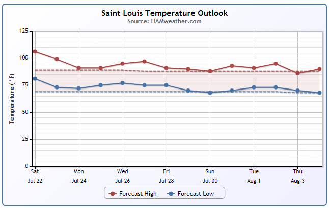
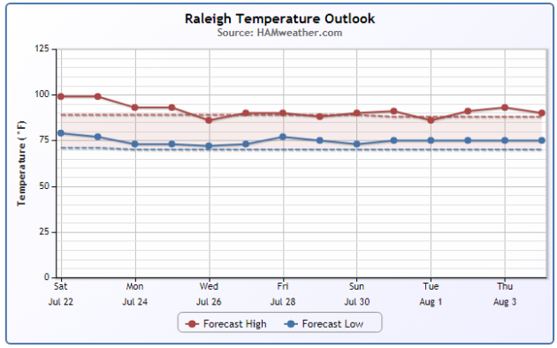
Hot Week Ahead
Take a look at the extended forecast below for St. Louis, MO and Raleigh, NC below. Note that after several days of dangerous heat, the excessive heat looks to finally break a bit into early next week. Temperatures may finally get back to near normal levels as we head into the last week of July. However, there still could be a few heat spikes in St. Louis with temps nearing 100F again.
________________________________________________________________________
In the Calm Eye of a Meteorological Storm
By Paul Douglas
By Paul Douglas
Some days I daydream what it would be like to live in a place with no weather. No, not Pluto. Say San Diego? "What time will the fog burn off? Will it get to 82 or 84F?" That would be fun for a few weeks, and then I would succumb to boredom. Phoenix heat? Florida, where locals shuffle around in furs and boots when winter temperatures fall into the 50s? I'd injure myself laughing.
We get 4 real seasons in Minnesota. Plenty of variety; sometimes too much variety! But rarely is it dull.
Until the Summer of '17. Weather systems are in a holding pattern, fronts floundering in slow-motion.
A faint puff of Canadian air drops temperatures and humidity levels Sunday and Monday. Better sleeping weather. We warm up later in the week but dangerous heat, extended days or weeks above 90 or 100F, stays south of Minnesota into early August.
Meanwhile, exceptional drought is gripping the Dakotas (impacting wheat prices), while Chicago and parts of Wisconsin are underwater from waves of severe thunderstorms and blistering heat grips the nation's breadbasket. We are relatively lucky this year.
________________________________________________________________________
Extended Forecast
SUNDAY: Partly sunny and cooler. Winds: NW 7-12. High: 79
SUNDAY NIGHT: Mostly clear and comfy. Winds: N 5. Low: 60
MONDAY: Sunny and pleasant. Light winds. Winds: SE 5-10. High: 81
TUESDAY: Sticky with scattered T-storms. Winds: S 7-12. Wake-up: 64. High: 86
WEDNESDAY: Few T-storms, especially southern MN. Winds: NW 5-10. Wake-up: 68. High: 82
THURSDAY: Plenty of sun. Drier day. Winds: NE 3-8. Wake-up: 65. High: 84
FRIDAY: Blue sky. Not too many complaints. Winds: N 3-8. Wake-up: 66. High: 85
SATURDAY: A fine, sunny summer day. Winds: NW 3-8. Wake-up: 67. High: 86.
_______________________________________________________
_______________________________________________________
This Day in Weather History
July 23rd
July 23rd
1987: The greatest deluge ever recorded begins in the Twin Cities, with 10 inches of rain in six hours at MSP airport.
________________________________________________________
________________________________________________________
Average High/Low for Minneapolis
July 23rd
July 23rd
Average High: 83F (Record: 105F set in 1934)
Average Low: 64F (Record: 47F set in 1876)
Average Low: 64F (Record: 47F set in 1876)
Record Rainfall: 9.15" set in 1987
_________________________________________________________
_________________________________________________________
Sunrise/Sunset Times for Minneapolis
July 17th
July 17th
Sunrise: 5:49am
Sunset: 8:49pm
Sunset: 8:49pm
Hours of Daylight: 15hours & 00mins
Daylight LOST since yesterday: ~2 minute and 2 seconds
Daylight LOST since summer solstice (June 20th): ~37 minutes
__________________________________________________________
Daylight LOST since summer solstice (June 20th): ~37 minutes
__________________________________________________________
Moon Phase for July 23rd at Midnight
0.9 Days Since New Moon
0.9 Days Since New Moon

_________________________
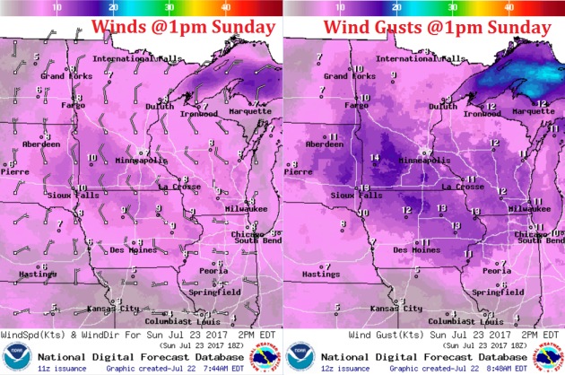
Weather Outlook For Sunday
Here's the weather outlook for midday Sunday, which suggests not only cooler temperatures in place, but also much more comfortable air in place as dewpoints fall from the 60s/70s to the 50s across much of the state!
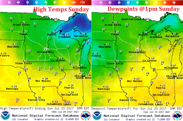
Weather Outlook For Sunday
On the backside of the storm system that brought us widely scattered showers and storms over the last couple/few days, winds will turn out of the NW, which will allow cooler, less humid air to move in on Sunday. Winds could be a little gusty at times over open areas with gusts approaching 15/20mph through the afternoon.
Weather Outlook For Sunday
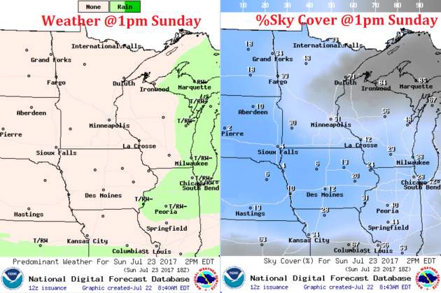
Here's the weather outlook for midday Sunday where areas of clouds will linger across the Arrowhead, parts of eastern Minnesota and into northern Wisconsin. The good news is that we will stay dry under partly to mostly sunny skies.
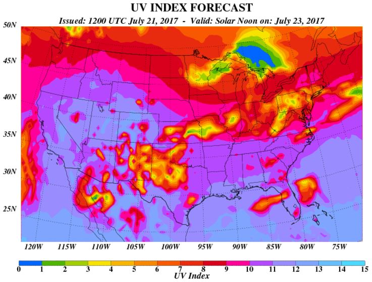
UV Index for Sunday - HIGH
The UV Index will be considered HIGH across much of the state of Minnesota on Monday, which means that it will only 20 to 30 minutes or less to burn unprotected skin. With that said, if you are planning on spending any extended length of time outside, make sure you wear appropriate attire and lather on the sun block!
 __________________________________________________________________________
Weather Outlook For Monday
Monday will be another very comfortable day across the region, especially considering that it is late July. High temps will spread from the 70s across northeastern MN to the low/mid 80s across the central and western part of the state. The good news is that dewpoints will still be very comfortable in the 50s.
M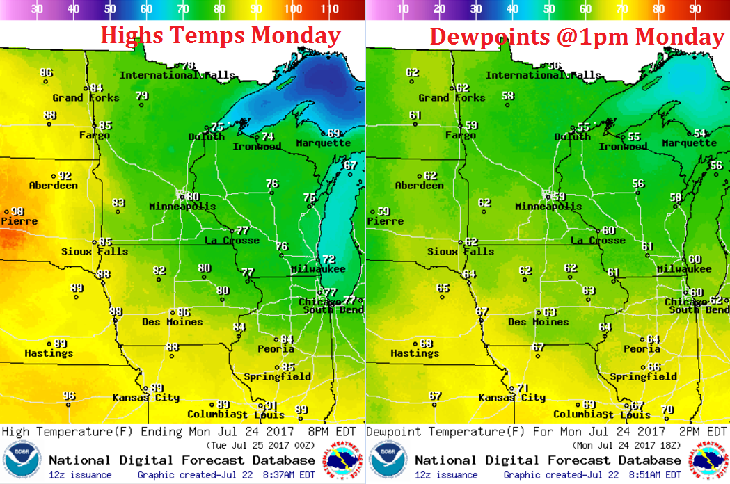
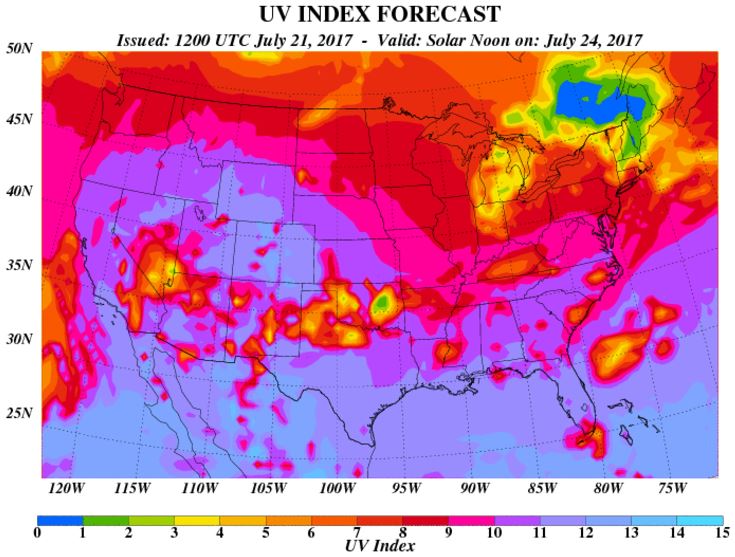
UV Index for Monday - VERY HIGH
The UV Index for Monday is expected to be VERY HIGH once again, which means that your skin could burn in 15 to 20 minutes or less!
 _____________________________________________________________
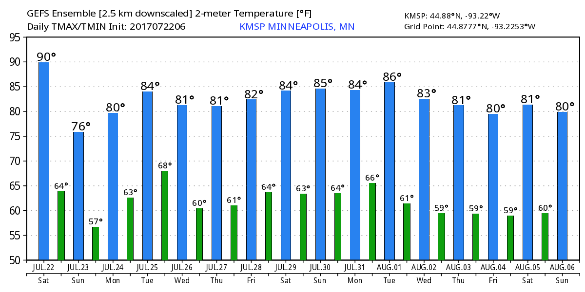
Minneapolis Temperature Outlook
Here's the temperature outlook through August 6th, which shows temperatures taking a little bit of a dip on Sunday compared to where we were on Saturday. As we head through the last full week of July, temperatures will slowly climb into the 80s. The forecast into early August keeps temperatures in the low to mid 80s. Stay tuned...
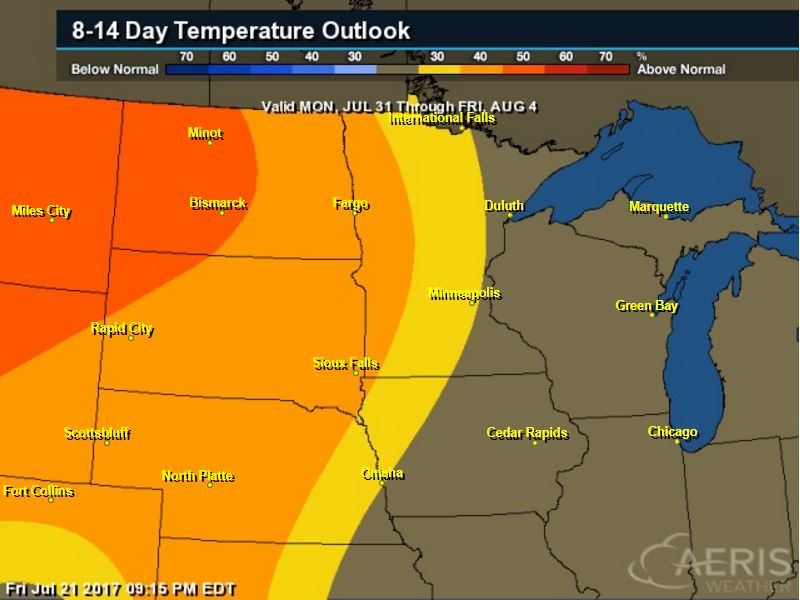
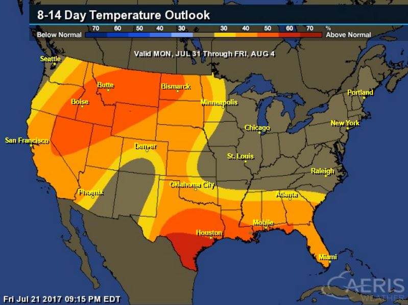
8 to 14 Day Temperature Outlook
According to NOAA's CPC, the extended temperature outlook from July 31st to August 4th suggests warmer than average temperatures continuing across much the western half of the Upper Midwest as we head into the early part of August. Temperatures closer to the Great Lakes may be a little closer to average.
___________________________________________________________
Extended Temperature Outlook
According to NOAA's CPC, the extended temperature outlook through August 4th shows much of the nation will be dealing with above normal temperatures as we head into early August. However, temperatures across the northeastern part of the country and some in the Desert Southwest could be a little closer to average.
Extended Temperature Outlook
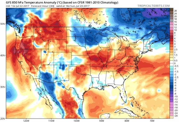
Here's the extended 850mb temperature anomaly loop into next weekend. This describes how warm or cold (from average) mid/low level temperatures will be over time. Note that the warmer oranges and reds are still in place across much of the nation, but there are some cooler blues moving in across the Midwest/Great Lakes/Ohio Valley and the Northeast through the week. While it'll still be hot for much of teh nation, places like St. Louis, MO and surrounding areas will get a nice break from the ridiculous heat that has been in place there over the last several days.
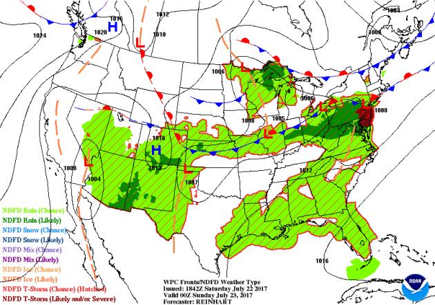
Weather Outlook Ahead
The weather outlook over the next couple of days shows stormy weather continuing across parts of the Southern and Eastern US. Some of the storms in these areas could be strong to severe with locally heavy rains. There could also be a few strong storms in the Southwest with locally heavy rain, but heavy rain also looks to be possible in the Upper Midwest as we head into early next week.
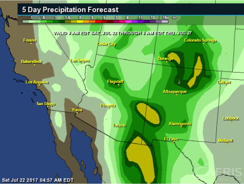
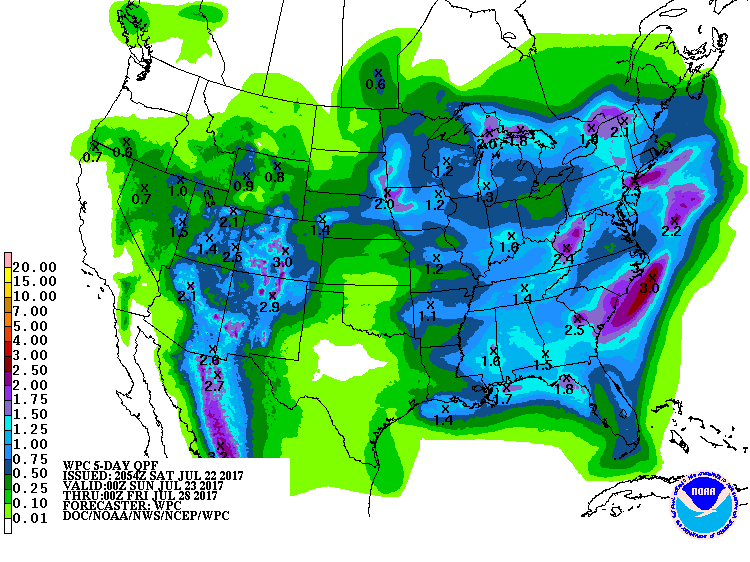
5 Day Precipitation Outlook
According to NOAA's WPC, the next several days could produce areas of locally heavy rainfall across parts of the Eastern half of the country with some locations seeing as much as 1" to 2"+ rainfall, which could lead to areas of flooding. There will also be areas of heavy rain in the Southwest due to monsoon storms with some 3"+ tallies possible there.
 ___________________________________________________________________
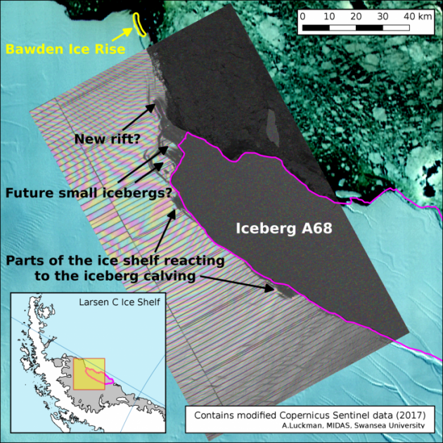
"New rift found in Antarctic ice shelf just weeks after 1 trillion tonne iceberg broke free"
"Just weeks after a massive 1 trillion tonne iceberg broke free from Antarctica, scientists have found a brand new crack in the Antarctic ice shelf. Researchers monitoring the Larsen C ice shelf and its response to the dramatic birth of the new iceberg suggest that the new rift may cause further loss of ice from the Antarctic region. "A new rift appears to be extending northwards (towards the top left) and may result in further ice shelf area loss," researchers at Project Midas, which is monitoring the changes of Larsen C and A68 said."
(Map of Larsen C, overlaid with NASA MODIS thermal image from July 12 2017, showing the iceberg has calved)
_____________________________________________________
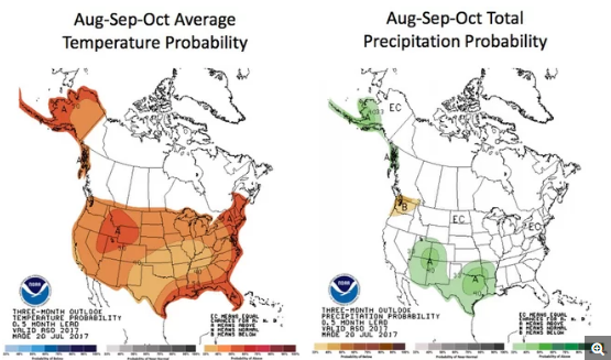
"The Weather Forecast for August, September and October? Hot!"
"Grab that iced tea — much of the U.S. has had a hot summer so far, and it's only going to get hotter, according to a report released today (July 20) by the National Oceanic and Atmospheric Administration (NOAA). For the next three months — August, September and October — the United States is predicted to have above-average temperatures, Dan Collins, a meteorologist and seasonal forecaster with the NOAA Climate Prediction Center-Operational Prediction Branch, said in news briefing today. "You can see that across the entire United States, including Alaska, there is more of a chance that temperatures will be above normal," Collins said. "
(The three-month forecast shows that the U.S. will likely have above-normal temperatures (right) and only slightly above-normal rainy conditions in the American Southwest and Alaska (left).)
__________________________________________________________
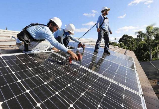
"New homes will now require solar panels in South Miami, a first in Florida"
"Anyone building a new house in South Miami — or in some cases renovating existing ones — will have to install solar panels after the city commission approved a groundbreaking law Tuesday night. The measure, the first of its kind in Florida, will go into effect in two months on Sept 18. The ordinance passed 4-1 Tuesday night, with commissioner Josh Liebman dissenting." "Under the rules, new residential construction would require 175 square feet of solar panel to be installed per 1,000 square feet of sunlit roof area, or 2.75 kw per 1,000 square feet of living space, whichever is less. If the house is built under existing trees, the shade may exempt it. Home renovations that replace more than 75 percent of the structure or extend the structure by more than 75 percent would also have to follow the new ordinance. South Miami Mayor Philip Stoddard, a biology professor at Florida International University, has championed this measure. His entire home runs on solar and he drives an electric car. His monthly electric bill is about $10."
(South Miami passed a new law on July 18, 2017, requiring all new homes built in the city to have solar panels, the first such measure in Florida. The law, which goes into effect in September, also applies to some residential renovations. Al Diaz adiaz@miamiherald.com)
______________________________________________________
Thanks for checking in and don't forget to follow me on Twitter @TNelsonWX

No comments:
Post a Comment