64.1" snow so far this winter.
89" amount of total snow necessary to catapult the Twin Cities into 3rd place, the 3rd snowiest winter on record. 85.3" has already fallen on the Minneapolis/St. Paul metro area so far this winter.
Winter Weather Advisory: nothing is posted yet, but I expect the NWS to issue an advisory within the next 12-24 hours, possibly a Winter Storm Watch for parts of southeastern MN and western WI.
Tuesday evening/night: heaviest snow likely from 5 pm Tuesday through 8 am Wednesday.
2-4" snow possible in the St. Cloud metro area by Wednesday morning, closer to 3-6" in the Twin Cities area.
60s likely next week in the Twin Cities. Welcome to spring in Minnesota.
Sunday Halo.Thanks to Broadcast Weather meteorologist Susie Martin for snapping this photo of an impressive halo Sunday afternoon. White sunlight being refracted (bent) by billions of tiny, prism-like ice crystals, creates a rainblow of color. Click
here for a good explanation on optical illusions (called "parhelia") like halos, sundogs, rainbows and coronas form.
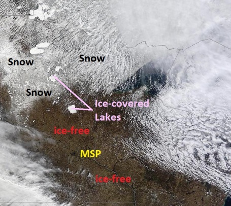
Sunday Satellite Snapshot. NASA's "Terra" satellite captured this high-res image of Minnesota yesterday, showing ice lingering from Mille Lacs and Gull Lake on north to Leech and Red Lake. There's still a few inches of snow on the ground from near Wadena to Crosslake to Aitkin and Grand Rapids. Click here to see the latest high-res image.
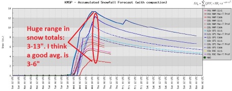
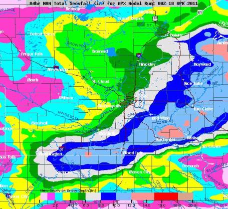
Insert Deep Sigh Here. The good news: we probably won't pick up a foot of slush. The bad news: the atmosphere should be cold enough for snow Tuesday night into Wednesday morning. The latest (00z) NAM prints out .45" liquid for the St. Cloud area. If it were all snow we'd pick up 5-6" of heavy, wet snow. I suspect some of this will fall as rain Tuesday afternoon/evening, and some of the snow will melt on contact with a relatively mild ground (keeping final amounts down). That's why I'm predicted 2-4", with some 6" amounts possible south/east of St. Paul. Whatever falls should be pretty much gone by Thursday afternoon. If not I'm packing my bags and hitchhiking to Dubuque.
What Month Is This Again? Some April. Yes, the models have been consistently over-estimating snowfall amounts in recent weeks, so I'm discounting what ALL the models are saying. That said, I'll be amazed if we escape without any accumulating snow Tuesday night into Wednesday. I do NOT think we'll wind up with 18", but by the same token I doubt we'll escape with an inch or two either. Right now a good mid-range (average) range would be something in the 3-6" range, more south of the Twin Cities, closer to the storm track. The St. Cloud area, farther from the storm track, may see 2-4".
Potentially "Plowable". Yes, I'm really looking forward to ditching the word, "plowable". Replacing it with "balmy"..or maybe "showery". Anything but plowable. The latest
NAM solution shifts the heaviest snow amounts south/east of the Twin Cities metro, but (if the models are on the right track) there could still be some 3-6" amounts, with an outside chance of 8" of slush by Wednesday morning, especially east of St. Paul.
I'm expecting closer to 2-4" for the greater St. Cloud area.
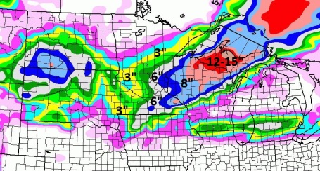
GFS Solution. There are strong similarities with the NAM solution, showing the heaviest snow bands just south/east of MSP. But the GFS is even more aggressive with amounts, suggesting some 12" amounts for far southeastern Minnesota.
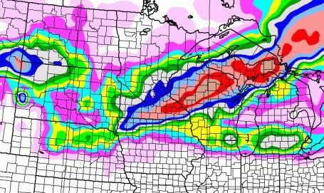
Potentially Plowable Tuesday Night. The models can't seem to agree on anything, but the latest NAM solution shows the heaviest bands of wet snow setting up over the south and east metro late Tuesday into Wednesday morning, possibly some 5-6"+ amounts south of the Minnesota River and east of the St. Croix River. If I had to give a range right now I'd probably (reluctantly) go with 3-6",
but closer to 2-4" for St. Cloud. I wouldn't be shocked to see some 8" amounts from near Mankato and Northfield to Red Wing and Rochester, into much of west central Wisconsin. We'll see.
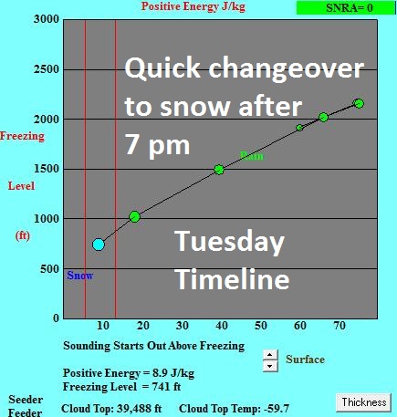 Timing
. Right now the latest (NAM) guidance, probably more reliable than the GFS model, suggests a fairly rapid changeover from rain to snow around 7 pm tomorrow evening. As precipitation begins temperatures will rapidly cool to the wet bulb temperature, close to freezing - and strong upward motion overhead Tuesday night will also tend to cool the layer. Right now it looks like mostly-snow.
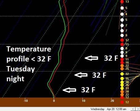 A Cold Profile
. Are you sure it's the third week of April? As far as the atmosphere is concerned it's the first week of March. The red line is the predicted temperature "profile" with altitude at midnight tomorrow night, showing a temperature curve well below freezing throughout the lowest mile of the atmosphere, cold enough to ensure mostly snow. Great news.
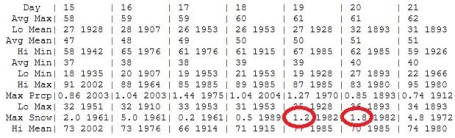
Chance Of A Snowfall Record Or Two? According to the Minnesota State Climatology Office, the single-day snowfall record for Tuesday (April 19) is 1.2", for Wednesday (April 20) it's 1.8". Both records stand a good chance of being broken this week. Hey, if it's going to snow this late in the season let's at least break a few records and make a little "news". Check out the April averages and records for MSP
here.
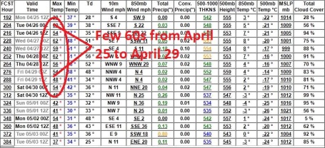
Welcome Rerun of Spring. The GFS continues to bring a real warm front wafting into town by Monday, April 25. Expect 3 or 4 days/row with highs at or above 60, followed b a cooler front as we sail into the first week of May.
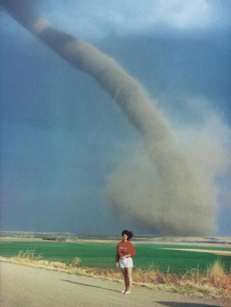
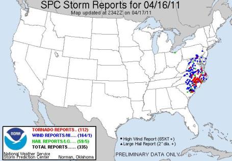
Sunday Outbreak: 112 Tornadoes. Every time I check in the Storm Prediction Center has increased the number. SPC is now reporting 112 confirmed tornadoes on Saturday from Maryland to South Carolina. North Carolina was hit the hardest. Details
here.
 Keeping Perspective: Preliminary Vs. Final Tornado Reports
. Patrick Marsh has an
interesting post about establishing a reliable tornado count. Is SPC overestimating or underestimating tornado reports on a routine basis: "
Over the last few days, the southern United States has endured a significant severe weather event that took the lives of a still increasing number of people. While many communities are still trying to sift through the wreckage, meteorologists, “meteorologists”, chasers, and other weather enthusiasts have taken to Facebook and Twitter to discuss what has happened. Unfortunately, a lot of misinformation is floating around. Here’s my quick attempt to clarify some of this information. As of this writing, 248 preliminary tornadoes have been reported via the Storm Prediction Center’s Preliminary Storm Report webpage over the three days 14-16 April 2011. Much has been made about this number. Unfortunately this number contains many duplicate tornadoes, and potentially even some tornadoes that never were. Hence the label “Preliminary”. Over the next few weeks, National Weather Service Offices throughout the south will be conducting damage surveys to determine the number of actual tornadoes to the best of their ability. There is no doubt that this has been a significant three-day tornado outbreak. However, until the official numbers are released via the National Weather Service’s Storm Data publication, people should exercise extreme caution in trying to quantify where this week’s severe weather outbreak ranks in history. It used to be the case that the preliminary number of tornadoes underestimated the number of actual tornadoes. However, near March of 2006 the pattern reversed itself with the number of preliminary tornadoes typically overestimating the number of actual tornadoes. For more information regarding preliminary vs. final tornado reports, please read this blog post on the topic by Harold Brooks, which can be found on the United States Severe Weather Blog."
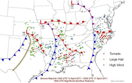
Incredible Outbreak. I counted at least 230 tornadoes from Thursday through Saturday, April 14-16. States hardest hit: Oklahoma (Thursday), Mississippi and Alabama (Friday), and North Carolina (Saturday). A full-screen version of the map is
here, courtesy of Victor Gensini.
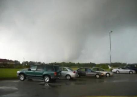
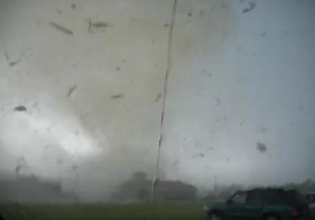
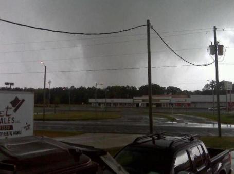
A Little Too Close. all the atmospheric ingredients came together Saturday for an Oklahoma-like outbreak of tornadoes in North Carolina on Saturday. Some of these were huge, 1/4 to 1/2 mile wide tornadoes, possibly EF-3 and EF-4 strength, what you might expect to see near Wichita or Oklahoma City, not Raleigh, North Carolina. Storm chaser Steven Hoag got dangerously close to the tornado that hit Wilson, North Carolina Saturday afternoon. The remarkable video clip is
here; a few more details: "
Video from Steven Hoag, who took it from the Fred's Food Club parking lot next to Walgreens in Wilson, NC, AS THE TORNADO is hitting Walgreens and nearby businesses on Forest Hills Road & Wooten Blvd. Video taken Saturday, April 16, 2011 in the late afternoon."
What Is A "Wedge" Tornado? When you think of a tornado you think of the classic funnel shape, straight out of the Wizard of Oz, or the movie "Twister". Sometimes tornadoes are so large and violent that they don't even resemble the classic funnel. Many of Saturday's tornadoes that descended from the skies over North Carolina were big, fat "wedge" tornadoes, in some cases nearly 1/2 mile wide, something you'd expect to see in Kansas, not the east coast. In some cases it must have looked like the entire rotating 'supercell" thunderstorm had descended to the ground. Two big tip-offs that it's a tornado, and not just a garden-variety thunderstorm: 1). rotation. If the entire cloud base is rotating visibilty that's a sign of impending trouble, and 2). large hail. The larger the hail, the stronger the updraft, and the greater the risk of tornadogenesis.
* NSSL has a good recap of how tornadoes form, and how you can better protect your family from these rare and violent wind storms
here.
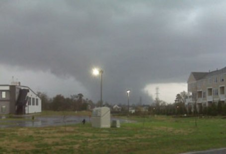
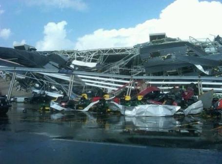
Extreme Damage. This is all that's left of a Lowes store in Sanford, North Carolina, courtesy of @benturnerlive and the
Ham Weather Biosphere blog, updated by meteorologist D.J. Kayser. The tornado that leveled the store is below.
Analysis Of A Super-Outbreak. Jeff Masters has a good summary of the North Carolina outbreak in his
Wunderblog. The photo above is of the tornado that went on to level the Lowes department store in the photo above: "
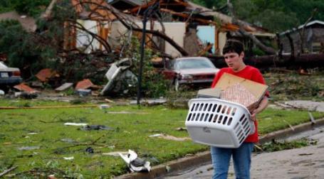
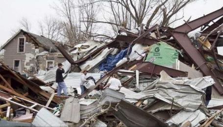
In a stunning display of violence, dozens of tornadoes rampaged through North Carolina and Virginia on Saturday, killing at least 25 people, injuring at least 130, and damaging or destroying at least 450 homes and businesses. Hardest hit in yesterday's outbreak was the the town of Askewville in northeast North Carolina, where a violent tornado that was likely at least an EF-3 ripped homes off their foundations and killed fourteen people. Also hard-hit was the Raleigh area, where a mile-wide EF-3 tornado with 140 - 150 mph winds roared through the downtown region, killing five people. The 22 deaths in North Carolina made yesterday's outbreak the deadliest day for tornadoes in the state since 1984, when the infamous March 28 tornado outbreak killed 57 people and injured 1248."
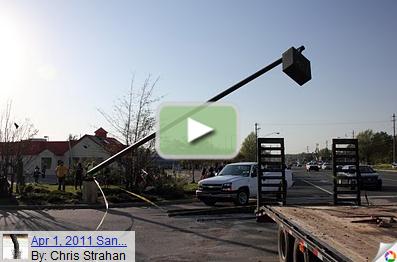
Incomprehensible Damage. Chris Strahan has photos of some of the damage in Sanford, North Carolina
here.
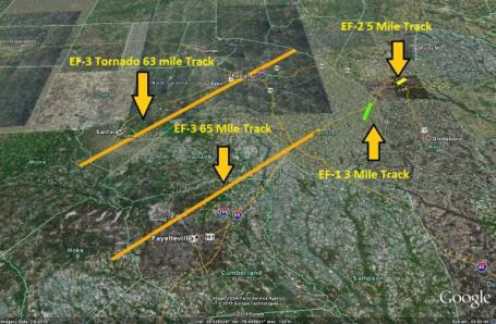
Kansas-Size Tornadoes In North Carolina? A convergence of meteorological factors, including unusually strong jet stream winds and "shear" (changing wind speed/direction with altitude) resulted in long-lasting tornadoes. Two of the tornadoes (both EF-3 strength) were on the ground 63 and 65 miles respectively, according to Brad Panovich from
WCNC-TV.
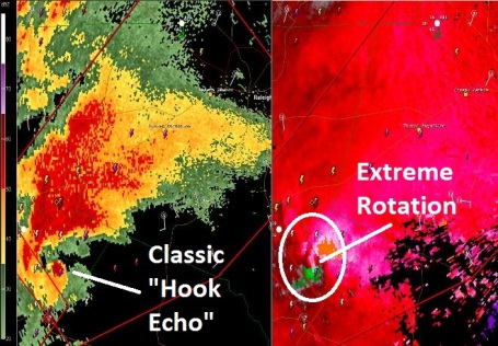
"Kansas-Size" Tornadoes. The one benefit of large, long-lasting tornadoes? They are impossible to miss on Doppler radar, giving meteorologists more time to get warnings to the public. It's the small, brief (EF-0 to EF-1) twisters, especially late at night, that can cause a disproportionate number of injuries because they're difficult to detect, and people are often asleep, simply not alert to the threat of tornadoes. That's where a NOAA Weather Radio becomes indispensable: the only device that will set off a (loud) audible alarm and wake you up in the middle of the night if YOUR county is under a warning. Doppler image courtesy of
Texas Storm Chasers.
Tracking "Supercells". WRAL-TV's (in-house) Doppler radar showed the individual hail and rotation cores from Saturday's historic outbreak. At one point the on-air meteorologist choked up as neighborhoods he knew from first-hand experience were being devastated by EF-2 and EF-3 tornadoes. All non-essential employees of the TV station were ordered to the basement, but the meteorologist and control room crew stayed on the air providing continuous coverage. It was TV meteorology at it's finest - the coverage almost certainly helped to save lives across North Dakota. More details on Saturday's deadly tornado swarm
here.
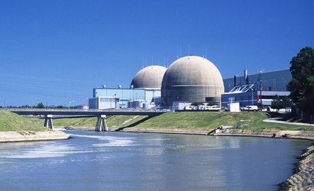
Tornado Cuts Power To Surry Nuclear Power Plant. Nuclear reactors and containment shields are designed and built to be able to withstand a direct strike from a tornado. To my knowledge there has never been a direct strike. Saturday's tornado swarm in shut off power to much of North Carolina, including a couple of nuclear power plants in southeastern Virginia, as
reported by the Williamsburg Yorktown Daily: "
The U.S. Nuclear Regulatory Commission staff is monitoring the situation at the Surry nuclear power plant after the site lost offsite power early Saturday evening due to a tornado affecting an electrical switchyard next to the plant. The NRC is monitoring the event through the NRC resident inspectors at the site and in the Atlanta regional office. The plant is operated by Dominion. The two units at the Surry plant automatically shut down after losing offsite power. Four of the plant’s diesel generators started to power the units’ emergency loads, an NRC spokesman said in a press release. Plant operators have partially restored offsite power to both plants, and safety systems have operated as needed."
Tornado Damages Oklahoma School, But Shelter Underneath Stands Strong. More details about the massive tornado that hit Tushka, Oklahoma last Friday from from the New York Times: "
The tornado hit, and for 10 minutes the sound was deafening. A cedar tree crashed to earth near one entrance of the shelter. A car was flipped over and landed next to another. Wind howled down the air vents in the ceiling and stirred up dirt and debris. “They were screaming: Get down! Get Down! Protect your head!” Ms. Davis recalled. Two residents of Tushka died in the storm, a pair of elderly sisters whose bodies were found in the debris of a house. Ms. Davis and the other people who sought safety in the shelter emerged to find a scene of chaos. The winds had torn off the top story of the original brick school building, erected in 1918, and left a pile of rubble. One of the two gymnasiums looked as if it had exploded. The sign saying Walter E. Cooper Gymnasium adorned a ruin. The roof of the newer annex to the school had been ripped off, and electric wires hung in the hallways."
EF-2 Tornado? No Problem - The Prom Must Go On. The Des Moines Register
reports on the aftermath of the massive tornado that destroyed much of Mapleton, Iowa. Even though much of the town was flattened, high school seniors rallied and (somehow) were able to have their prom: "
The tornado with its 136 mile-per-hour winds ripped through Mapleton a week ago with little more than 10 minutes' warning. But of course everybody saw prom coming ages ago. This is the high school rite of passage steeped in nervous anticipation, preparation, the awkward ritual of it all. The surprising part was that prom went on as planned Saturday for the 120 juniors and seniors of Maple Valley-Anthon-Oto High School, despite the destruction of more than 100 homes and the rearranging of so many lives. One minor change was the after-prom party relocated to nearby Anthon because of the leaky roof in Mapleton's elementary school gym."
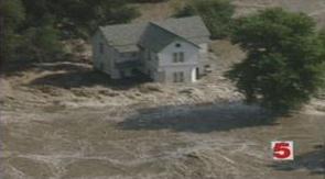
Are Severe Weather Events Becoming More Common? KSDK-TV in St. Louis tries to connect the dots: are these just (well-reported) but random severe weather events, or is there a common thread here? A though question, with no easy answers. Here is an excerpt from the
story: "
The Flood of '93, the tornado of 1896, Hurricane Katrina, all of these events have one thing in common. They were major catastrophes, each causing major loss of life and destruction. These types of storms are deemed as a 100 year event. "The 100 year storm is a statistical analysis that we meteorologist dreamt up," said Saint Louis University professor Dr. Bill Dannevik. "Assuming you have 100 years of observations of some sort of condition; whether it be rainfall, snowfall, wind speeds, flood levels. And if you look at that collection of data and you see a certain kind of event occurred one time in the 100 years of data you have. Then you would call that a 100 year event" Right now the climate is warming slowly and the issue is determining how much of the warming is natural and how much is human induced. "The evidence suggests that something like half, perhaps more, of the change that we're seeing can be related to the increase of the greenhouse gas emissions in the atomsphere," Dannevik explained. And these emissions over time cause warmer temperatures which means more fuel for weather systems."
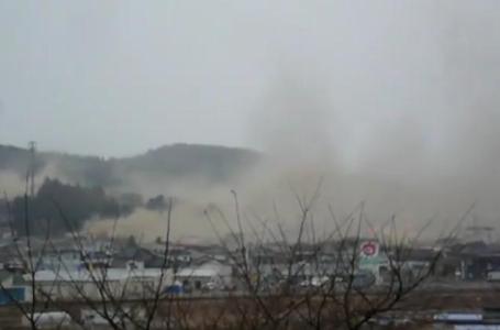
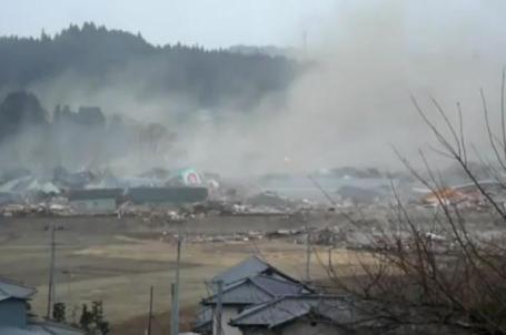
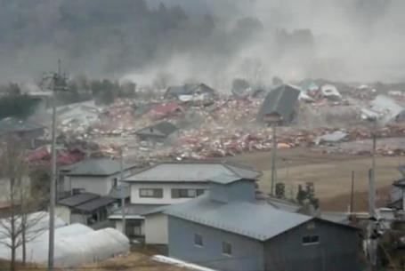
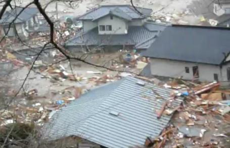
Nightmare Come To Life. This is some of the most
dramatic footage of the March 11 tsunami in Japan that I've seen yet. As we fret about slush and complain about the "winter that won't let go" let's try to keep a little perspective. At least snow won't carry away our homes. In light of recent tornadoes, earthquakes and tidal waves I'm gaining a new appreciation for Minnesota's relatively (reasonable) natural disasters. Here are the details from Mashable.com: "
We’ve seen a lot of footage of the tragic Japan tsunami, but this clip is the most horrifying yet. Entitled “South Sanriku — Tsunami seen from Shizugawa High School,” it’s shot from high ground, but toward the end of the video you can see panicked residents running for their lives. Almost as dramatic as the video is its audio track, where even if you don’t speak Japanese, you can tell the people are expressing concern at the beginning, but by the end, their voices have reached a high level of panic and horror as they watch their homes washing away. Shortly after the tsunami, one survivor called the oncoming deluge “a gigantic pile of garbage coming down the street.” That’s an apt description, as you can see an entire town reduced to a huge pile of watery debris in a matter of minutes. Shocking."
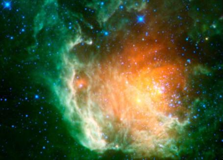
NASA Posts Thousands Of Spectacular New Photos. Interested in astronomy? The U.K.'s Daily Mail newspaper has an
update on a treasure-trove of new images available from NASA: "
You'll go starry-eyed at NASA's latest mission success - because the space agency has uploaded thousands of amazing space snaps onto the Internet, including shots of previously unseen galazies, stars and asteroids. The colossal gallery - available to anyone with a connection to the web - was taken by NASA's super high-tech sky-mapping telescope. It took a staggering two and a half million pictures of the universe, which include 33,000 new asteroids found floating between Mars and Jupiter - and 20 comets." The actual NASA images can be seen
here.
 The One Movie You Must See This Year.
 If you haven't already seen the documentary "Inside Job", go out of your way to track this down (it's available on iTunes to rent or buy - not sure if it's on Netflix yet). You know the story: a deregulated Wall Street took enormous risks, made bad bets, and taxpayers ultimately bailed out the Goldman Sachs of the world. Not one Wall Street executive has been prosecuted or indicted - no one has gone to jail for the Heist of the Century. Is the game rigged? I don't pretend to know, but if this doc doesnt' make your blood boil, nothing will. It's the most important movie you'll see for a very long time. The trailer for the movie is
here.
Want To Live To 100? Try To Bounce Back From Stress. Helen Reichert loves her chocolate truffles and Budweiser (hopefully not together). She's thinking of taking up smoking again. Helen Reichert is 109 years old, still living at home, still vital and sharp. What gives? NPR has the
story, and theories on why some people can live to a ripe old age (with most of their faculties intact): "
So what's going on here? Unusual longevity often has a genetic basis, and Reichert probably does have a gene that contributes to her unusual longevity. But she also exhibits a powerful trait geriatricians call adaptive competence. If you're a boomer and you don't think your outlook on aging has any impact on the rest of your life, you might want to brighten your attitude a bit. "I define it loosely as the ability to bounce back from stress. Many scientists view this solely as biological stress. But many of us who care for older patients see adaptive competence as psychologically critical as well. You don't get to be 109 without life hurling a few curveballs at you, and Reichert has had more than her share: bereavement, gender discrimination, medical issues. And after each, she dusts herself off and moves on."
"If you're a boomer and you don't think your outlook on aging has any impact on the rest of your life, you might want to brighten your attitude a bit."
- Dr. Mark Lachs
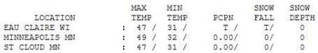
A Fleeting Taste of Spring. O.K. Consider it spring-lite, more like mid March in Minnesota, but with bright sun and light winds it felt pretty good out there yesterday. Highs ranged from 42 at Alexandria to
47 in St. Cloud, 49 in the Twin Cities.
Paul's SC Times Outlook for St. Cloud and all of central Minnesota:
TODAY: Mostly cloudy, cool & calm. Winds: E 8-13. High: 46
MONDAY NIGHT: Cloudy and chilly. Low: 34
TUESDAY: A cold rain changes to snow by late afternoon or evening. High: 40
TUESDAY NIGHT: Snow, potentially heavy at times - some accumulation is likely. Low: 30
WEDNESDAY: 2-4" possible. Heavier snowfall amounts possible south/east of the Twin Cities. Travel may be slow and slushy. High: 36
THURSDAY: Fading sun, much better. Low: 29. High: 47
FRIDAY: Happy to see rain again. Low: 34. High: 49
SATURDAY: Sun returns, hints of spring - probably the nicer day of the weekend. Low: 36. high: 53
SUNDAY: Clouds increase, milder. Low: 37. High: 57
* String of 60s likely next week as spring finally stages a comeback in Minnesota.
With All Due Apologies
&%*^%)&(*&!!!!!
This forecast should be censored, edited into a footnote, expunged from the print pages of the SC Times. It is with heavy heart and a partly-guilty conscience that I must (once again) predict a "plowable" snow for much of the area from Tuesday night into Wednesday morning.
For the record: I hope I'm wrong on this call. The models have been erratic and especially unreliable in recent weeks. The European (ECMWF) solution whisks the storm well south of Minnesota. But the NAM and GFS runs still bring a shield of significant snow into the southeastern third of Minnesota. A cold rain Tuesday afternoon changes to snow, heavy at times Tuesday night, a potential for 2-4" close to home before the flakes subside midday Wednesday. Another 3.7" and this becomes the 3rd snowiest winter on record for the Twin Cities, where 3-6" of snow may accumulate.
I know. The s-word should be banned from our lexicon until further notice. 85.3" is quite enough. Even though the models have been off in recent weeks I still suspect we'll experience at least one more "substantial" snow, and this may be it. Whatever does fall will melt within 24 hours; I see a string of 60s the last week of April. Hallelujah!
Welcome to the Winter That Just Won't Let Go.

Fossil-Fuel Will Dominate In 2030: ExxonMobile. Will it? If so the impact on our atmosphere and the environment in general will be incalculable, and future generations will be severely impacted. Here's an
article from The Nation: "
There is bad news for those determined to tackle global warming. No matter how desperately the world wants to reduce carbon emissions through a cut in fossil-fuel consumption, it seems an inescapable fact that such fuels will continue dominating global energy demand 20 years from now. "According to ExxonMobil's "Outlook for Energy: A View to 2030", in that year the combined demand for oil, coal and gas will remain at about 80 per cent of overall fuel needs, even with the increasing supply of nuclear, hydropower, biomass/wastes and other renewables. "Despite the sharp growth of other types of fuel], they will grow from a very low base," Rob Gardner, manager of the Economics and Energy Division of ExxonMobil's Corporate Strategic Planning Department, said during a recent briefing to the Nation Group. He predicts demand will rise 1.2 per cent per annum from 2005 to 2030, when the world's population will reach 8 billion. However, Gardner acknowledged during the briefing that the US giant's outlook had been completed prior to the nuclear disaster in Japan, which is now swaying development plans in several countries and could send the demand for oil, coal and gas even higher."
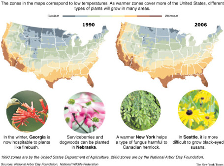 Global Warming Effect On Plants.
 A good summmary of the impact of warming on plants in this
article from opposingviews.com: "
With certain areas of the world getting progressively warmer, various life forms like plants are beginning to feel the impact. Overall, the affect of global warming on plants has been both positive and negative, and may be a preview to what the change in climate could mean for humans. As a result of the warmer weather, plants are featuring increased microbial action in the soil, which makes the plants more productive. The combination of hotter temperatures and strong winds, both of which are results of global warming, tends to speed up the spreading of plants, pollen and seeds. This helps plants survive and reproduce in nature – something that is desperately needed given the damage done to forests over the past decade. Further, while less snow cover tends to lead to more thawing and refreezing of soil, the impact on the roots of plants is offset by the increase in microbial action. And, of course, it’s that microbial action that ultimately makes the plants more productive. Global warming also has a very specific, noteworthy impact on weeds. As a result of warmer weather, invasive plants will tend to move to areas with a higher temperature. This should then provide some very necessary space for an increasing number of plants that have otherwise been constricted."
Wyoming's Boom Poses Challenge For Obama. The New York Times
reports on an improving economy in Wyoming, and how that's actually bad news for President Obama and his energy policy: "
The bottom-line message is that the climb out from this recession, if Wyoming is any measure, could be as politically turbulent as the descent. Economists say administration policies to reduce imported energy, along with higher commodity prices, are bolstering what Wyoming has to offer — natural gas and oil, coal so near the surface it can be harvested without underground mines and endless wind for electricity turbines. But many other residents here say they still see Mr. Obama as the enemy of Wyoming’s mineral bounty. “He’s perceived as the energy killer,” said Barrett K. Norris, co-owner of Thunder Basin Homes, a manufactured housing company in Gillette."


No comments:
Post a Comment