64.1" snow so far this winter in St. Cloud.
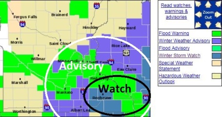
Winter Weather Advisory posted for the Twin Cities.
The advisory does NOT include St. Cloud.
Winter Storm Watch in effect for far southeastern Minnesota
1-2" predicted for the St. Cloud metro area by midday Wednesday.
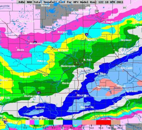
5-10" snow anticipated for far southeastern Minnesota, closer to Rochester, Winona and Lake City.
Heaviest snow expected from 6 pm this evening through 2 or 3 am Wednesday morning.
Freeways/interstates stay mostly wet, but some accumulation is likely on secondary roads and bridges by Wed. AM.
1.2" record snowfall for today in the Twin Cities (set on April 19, 1982).
1.8" record snowfall for tomorrow (set on April 20, 1982).
* I doubt the Twin Cities will see the 3.7" additional snow necessary for this to become the 3rd snowiest winter on record for MSP, but it may be a close call.
 April Slush
. Snow is on the way, a little rain/snow mix developing this afternoon (spreading in from the south), changing to all snow after 6 pm or so, but with temperatures above 32 F. roads should stay wet up until 8 or 9 pm. Snow will first start to stick on lawns and fields, some side streets and secondary roads will become slushy by 10 or 11 pm tonight. I think we'll wake up to 2-3" snow across much of the metro area, maybe a few 3-5" amounts over the far southern and eastern suburbs. Whatever falls will melt (quickly), possibly by the end of the day Wednesday. The sun returns Thursday, we should top 60 Sunday. No worries - this too shall pass.
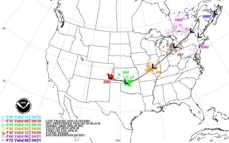
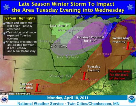
Snowy Scenario. There is still considerable disagrement between models (GFS, which has a "southward bias", takes the heaviest snow bands well south of MSP - while the NAM, which tends to be a little more reliable in general, brings the heavier snow bands a little closer to the southern and eastern suburbs of the Twin Cities). More from the local NWS office
here.
 Southward Detour
. The ideal storm track for heavy snow in the Twin Cities is roughly Omaha to Des Moines, Lacrosse and Wausa. Today's storm will track about 200 miles farther south/east, meaning a glancing blow of light to moderate snow for us from late afternoon through Wednesday morning - the heaviest snow bands clipping far southeastern MN.
Dueling Models:
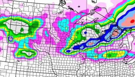
Solution #1. Why should the two main models agree (on anything?) The GFS solution keeps significant snow well south/east of MSP, with only an inch or two for the Twin Cities, but some 4-8" amounts over far southeastern MN and much of central Wisconsin. The GFS has been consistently whisking the storm well south/east of MSP. It seems that the NAM is trending closer to the GFS
solution, meaning a little less snow for MSP than earlier thought.
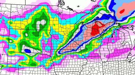
Solution #2. The NAM model runs keeps the heavy snow band closer to the Twin Cities. The most significant snows should still set up south/east of the metro area, but the NAM keeps some 6+" amounts close to the far southern/eastern suburbs of the metro area by Wednesday. This is why we're hedging our bets, splitting the difference, why I suspect 2-3" may be closer to what we ultimately wind up with across much of the metro area, with 5" amounts possible from Northfield to Rosemount and Hastings. The northwestern suburbs, Elk River, Monticello and Medina, may only pick up an inch or two.
Winter Weather Advisory Metro - Winter Storm Watch Far Southeast MN. The NWS has downgraded the Winter Storm Watch to a Winter Weather Advisory (GFS hinting that the heaviest snow will stay south/east of the Twin Cities metro area).
The advisory does NOT include St. Cloud. A Winter Storm Watch is still in effect for Rochester, Winona and all of far southeastern MN. More from the NWS on the watch here:
URGENT - WINTER WEATHER MESSAGE
NATIONAL WEATHER SERVICE TWIN CITIES/CHANHASSEN MN
409 AM CDT MON APR 18 2011

...A LATE WINTER STORM BEARING DOWN ON THE UPPER MIDWEST BY TUESDAY
   AFTERNOON...

.THE NATIONAL WEATHER SERVICE HAS ISSUED A WINTER STORM WATCH FOR
PARTS OF SOUTH CENTRAL AND EAST CENTRAL MINNESOTA AND WEST CENTRAL
WISCONSIN FOR TUESDAY EVENING THROUGH NOON WEDNESDAY. THE WATCH
WAS LOCATED MAINLY SOUTH AND EAST OF A LINE FROM SLEEPY
EYE...GAYLORD...MINNEAPOLIS TO CENTER CITY IN MINNESOTA...AND
LUCK AND RICE LAKE IN WISCONSIN.

A LOW PRESSURE SYSTEM OVER THE PACIFIC NORTHWEST...WILL TRACK
EAST OVER THE CENTRAL ROCKIES LATER TODAY...THEN MOVE EAST AND
STRENGTHEN OVER THE UPPER MIDWEST ON TUESDAY. ACCUMULATING SNOWS
ARE LIKELY OVER PARTS OF SOUTH CENTRAL AND EAST CENTRAL MINNESOTA
AND WEST CENTRAL WISCONSIN. THERE IS THE POTENTIAL FOR HEAVY WET
SNOW WITH TOTAL SNOW ACCUMULATIONS OF SIX INCHES OR MORE OVER
PARTS OF SOUTHEAST MINNESOTA AND WESTERN WISCONSIN BY WEDNESDAY
AFTERNOON. THERE COULD BE A BRIEF PERIOD OF SLEET BEFORE MIDNIGHT
TUESDAY.

THERE REMAINS SOME UNCERTAINTY IN THE TRACK AND
INTENSITY OF THIS STORM SYSTEM... SO CONTINUE TO MONITOR THE
LATEST FORECASTS AND STATEMENTS FROM THE NATIONAL WEATHER SERVICE.
How Much? The trends seem undeniable at this point: the heaviest
snow amounts setting up over far southeastern MN by Wednesday morning.
Still thinking 1-2", give or take.
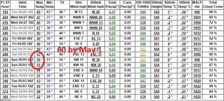
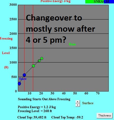
Timing The Changeover To Snow. The latest Bufkit package hints at a possible cold rain during the afternoon today, rapidly changing to wet snow after 4 or 5 pm. With air (and ground) temperatures above 32 F. I expect roads to be wet into the evening hours today, but
snow may start to stick after 8 or 9 pm, especially on side streets, bridges and secondary roads.
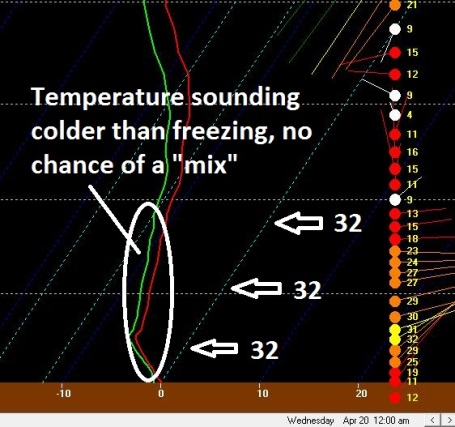
A Snowy "Sounding". The NAM model predicts temperatures throughout the lowest mile of the atmosphere will be (well) below freezing by midnight tonight, implying all snow from 6 or 7 pm through the morning hours Wednesday. You'd expect to see this kind of a temperature profile in mid March, not mid April. But that's the kind of winter season we're having...
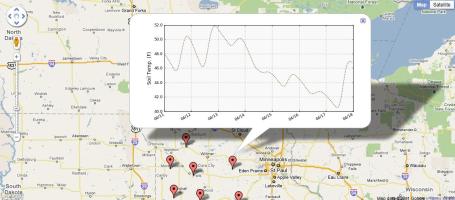
Another Factor To Consider. If anyone asks the soil temperature just west of MSP is a balmy 46 F. Who cares? Ground temperatures are still relatively mild, and for a few hours Tuesday evening snow will melt on contact with a relatively warm ground. It will take a few hours for soil temperatures to cool down to 32, and for the snow to STICK. That's why I'm going 2-3", and not 5 or 6", which is what .39" of liquid would equate to (with a rough 13:1 snow:rain ratio). If you're bored beyond recognition and want to check out soil temperatures click
here, data courtesy of the MN Dept. of Agriculture.
 A Reluctant Spring
. Whether it's a lingering La Nina pattern or something else at work, I still don't see any sustained warmth looking out 2 weeks or so, no prolonged 60s or 70s. Yes, it's annoying, this "backwards spring", but there is one big silver lining:
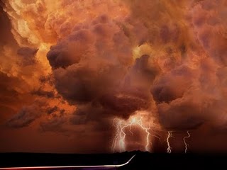
it delays tornado season in Minnesota. Snow or tornadoes? Good grief - what a choice.
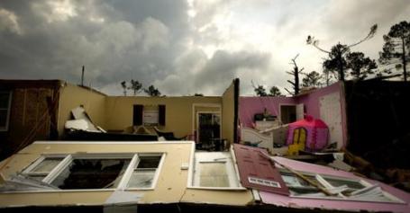
15 State Tornado Outbreak Deadliest Since 2008. Yahoo News and AP have an
update on the extensive swarm of tornadoes that swept across the south and east, from Oklahoma, Mississippi and Alabama to North Carolina last weekend: "
The devastation is stunning — homes and lives shattered as the deadliest swarm of twisters in three years battered up to 15 states. Ultimately, this could turn out to be among the top 10 three-day outbreaks for number of tornadoes, though experts can't be sure until all the reports are sorted, said Greg Carbin of the federal Storm Prediction Center in Norman, Okla. While tornadoes occur regularly, their power always shocks. This time it was storms battering their way from Oklahoma to North Carolina, claiming at least 44 lives, almost half of those in North Carolina. It was the deadliest since Feb. 5, 2008, when 57 died in the "Super Tuesday" election day tornadoes in the Southeast. And that was the highest tornado death toll since 76 died in 1985. "A major storm system like this is going to happen every few years, usually in April or May," said Carbin. While May is the nation's busiest month for twisters, they surge sharply in April, and most early spring tornadoes strike the Southeast and South Central states. Indeed, the biggest tornado outbreak on record occurred April 3-4, 1974 when 147 confirmed twisters touched down in 13 states, claiming 310 lives in the United States and 8 in Canada.
For about the past 30 years, the United States has averaged 135 tornadoes in April, the highest number being 266 in 1974, according to Jake Crouch of the National Climatic Data Center in Asheville, N.C. In these latest storms, the National Weather Service is investigating 267 preliminary tornado reports — including 97 in North Carolina on Saturday. But many of those will turn out to be duplicates, Carbin said in a telephone interview."
* Unlike tornado outbreaks of the past, the National Weather Service reports that nearly 90 percent of the past weekend's reported storms occurred in areas where tornado warnings were in effect. In central North Carolina, 97 percent of the tornadoes were in areas where warnings had been issued, with an average lead time of almost 26 minutes.
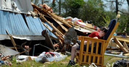
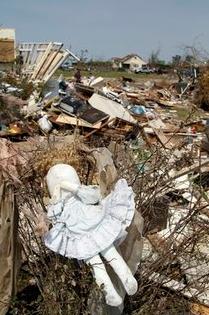
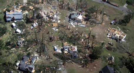
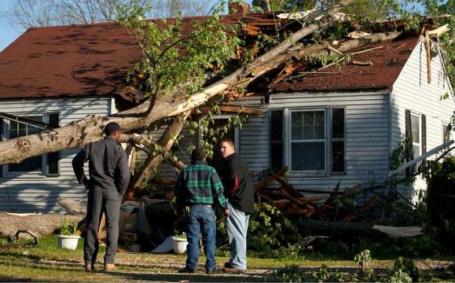
Kansas-Size Outbreak. An aerial photo shows some of the approximately 30 houses severely damaged or destroyed by a tornado in the St. Andrews neighborhood just south of Sanford, N.C., Sunday, April 17, 2011. (AP Photo/The News & Observer, Thomas Babb).
After Violent Storms, A Widespread Path of Death And Damage. A good summary of Saturday's record tornado outbreak in North Carolina from the New York Times
here: "
The terrified look in one of her employee’s eyes was the first clue Terri Rodriguez had that something was terribly wrong Saturday afternoon. The worker had been washing kitchen equipment behind Golden Corral, a popular restaurant in Sanford, N.C., when he spotted a giant black funnel cloud bearing down. It was one of more than 90 tornadoes — what one meteorologist described as a “family” of them — that hit the state on Saturday. He ran to Ms. Rodriguez, who walked out the back door. She dodged a piece of flying wood, and then she saw it: a dark funnel cloud thick with wood and metal only a couple of blocks away. About 140 people were eating in her restaurant, many of them in front of the thick plate-glass windows that run the length of the place. “All I could think is that I have to get them away from the glass because I knew it would just cut them in half,” she said in an interview on Sunday. “I thought, where can I put them? Then I yelled: ‘Tornado! Everyone to my kitchen!’ ”
Tornadoes Kill At Least 43 In North Carolina And Elsewhere. The NY Times has the
details: "
At least 22 people were killed after violent tornadoes roared through the city of Raleigh and across the heart of North Carolina Saturday afternoon and evening, state officials said Sunday. The storms also severely injured 130 other people and leveled or damaged hundreds of homes, demolished a big-box store and a trailer park, plucked trees out of the earth, and left more than 84,000 people without power....The North Carolina toll would have been far higher had it not been for a canny manager of a Lowe’s home improvement store in Sanford, 40 miles southwest of Raleigh. Patty McQuillan, a public information officer for the state’s Division of Emergency Management, said the manager, who was not immediately identified, hustled more than 100 customers and workers into the more fortified rear of the store into offices before the front of the cavernous store collapsed. Witnesses said much of the store had been flattened, with jagged beams and siding poking out of the rubble, though no one was seriously injured. “It was really just a bad scene,” Jeff Blocker, a Lowe’s regional vice president, told The Associated Press. “You’re just amazed that no one was injured."
 Tornado Swarm Deals Death, But Also Miracles
. We all know how fickle tornadoes can be:
one home leveled, while across the street sits a home largely undisturbed. The New York Times has an
article highlighting these oddities, and minor miracles: "
ASKEWVILLE, N.C. — For all the deaths and broken bones and flattened houses, there were still some miracles packed into the 10 minutes it took for the last of a great roar of tornadoes to chew through this rural corner of the state. There was Glen White, 24, who found the strength to push up a wall that had fallen on five residents of a group home. There was the married couple who were thrown into their backyard as the storm exploded their home. They landed close enough, battered and bruised, to hold hands. And there was Molly, a graying donkey who for years has starred in the town Christmas pageant. People say they saw her lifted into the funnel cloud when the storm hit Saturday night. They thought she was a goner. But Sunday morning, her owner, Jake Dunlow, 75, found her on her back in a ditch about 300 feet away. A day later, she was grazing in her own pasture, oblivious to the splinters of seven mobile homes all around her."
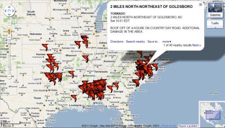
Interactive Tornado Count. Someone put together a pretty slick
interface, using Google Maps, that shows every tornado touchdown from last Friday through Sunday, based on damage reports submitted to SPC.
Fact-Checking The North Carolina Tornado Outbreak. In the heat of battle, the "fog of war", tracking EF-3 tornadoes and trying to make sense of what has happened, bad information often gets out. Accu Weather takes a look at what has been reported, and what is true/factual in this
interesting post:
Was the number of tornado reports a record breaker and how does that relate to the number of actual tornadoes? This is a point of contention, and it depends on who you ask. Although officially there were 240 tornado
reports during the 2-day outbreak, this number will be reduced considerably when the twister paths are investigated. As storm reports are easier to file with the National Weather Service due to better technology, the number of people seeing the same twister increases greatly. You can read
our news story on this for more information. It will be at least a week before we know how this outbreak compares to other major events. It's possible that this system could eclipse the worst outbreak in the states history, which took place on March 28, 1984. During that storm,
22 tornadoes killed 42 people in North Carolina.
UPDATE: CNN is reporting "97 confirmed tornadoes" though I find it hard to believe that the NWS would have had time to calculate that number yet.
Was the Raleigh tornado the widest ever in U.S. history? No. This was a typo in the NWS's
initial storm survey report which listed the width as "3." This was later reissued
CORRECTED FOR MAXIMUM PATH WIDTH of "0.3 miles." The widest tornado on record occurred i
n Nebraska in 2004, and was 2.5 miles in length.
Was where the tornadoes struck remarkable, in number, time of year or location? I don't believe so, but I'll have more information on this available later today.
Why did this happen? We are working on a story on what meteorological factors led to this outbreak, in this area, this time of year. It's unlikely, in my opinion, that long-term climatological factors, such as Global Warming or Cooling, had anything to do with this event, and pending answers to the questions above, it may not have been unprecedented.
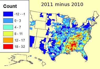
Busier Than Last Year. La Nina winters are often followed by unusually severe springs across the USA, an energized (and more powerful) jet stream capable of whipping up the extremes in wind aloft necessary to turn an ordinary thunderstorm into a tornadic "supercell" capable of large hail and twisters. From the
Iowa Environmental Mesonet: "
This past weekend saw yet another severe weather outbreak with numerous tornadoes reported over the deep south. The featured map (click for a better view) shows the difference in number of severe and tornado warnings this year versus last year. Only counties shown in dark blue have seen a decrease. The deep south certainly stands out with Alabama having all counties with higher totals than last year. The total count in this plot is 4,779 warnings for 2010 and 14,517 warnings for 2011. The total count for 2011 is the largest on record for the period prior to 18 April."
Tornadoes "Unpredictable"? Hardly. The site "
Meteorological Musings" examines the question: if there was so much warning and lead time with Saturday's North Carolina tornado outbreak, why did a couple dozen people still have to die? The answer seems to center on the tricky, sticky topic of mobile homes. An estimated 30-40% of all tornado deaths in the USA occur in mobile home parks - people simply have inadequate protection from tornadoes unless they can reach an underground shelter within a minute or two: "
So, why did people die? Given the sheer number of tornadoes and the strength of the tornadoes combined with the population density of the affected areas, some deaths were inevitable. I'm told that most communities in North Carolina do not have tornado sirens, which might be a factor. It is too soon to know if everyone received the warnings in time (i.e., in the 2007 Greensburg, KS tornado, everyone but a trucker from California received the warning as far as can be determined). The NWS will likely make these determinations via their damage surveys. Based on early news reports, at least half of the deaths in North Carolina were associated with mobile homes. A helicopter shot I saw clearly showed at least some nearby mobile homes were not tied down. It is my opinion, based on years of study and research, that an untied mobile home is completely unsafe in a tornado. We are getting to the point in America that the issue is not so much whether there will be an advance warning but making sure that everyone who needs to receive the warning gets it."
(Screen capture above is from WRAL-TV helicopter video showing the mobile home pad (upper left) and the stripped mobile home chassis moved off the pad. The mobile home may have tumbled as it moved.)"
WJLA-TV (Washington D.C.) Responds To "Jeopardy" Fans Upset About Severe Storm Interruptions. I feel their pain. I can't tell you the number of people who called to complain about live tornado coverage on WCCO-TV when there were tornadoes on the ground. "Don't care, not my county. Get off the air! This is an especially good episode of Oprah!" I kid you not. I could tell you stories that would curl your hair. Would these viewers feel any different if an EF-3 tornado was heading toward
their neighborhoods? Probably. True, TV is limited by over-the-air technology - it does seem somewhat ridiculous (very 1990s) to warn 88 counties for a tornado impacting 10% of ONE county experiencing a tornado threat. New (mobile) innovations will soon make this problem a thing of the past - the ability to alert only the people in the direct path of a tornado or hailstorm, turning on their cell phones, telling them how many miles away the threat is from their current GPS location. That capability is coming, but not soon enough. Here is the
story from mediabistro.com: "
As a herd of tornadoes rumbled through much of the southeast this weekend, some viewers in D.C. blasted WJLA for interrupting “Jeopardy!” with severe weather updates. Now the ABC-affiliate is responding to its Alex Trebek-loving critics. In a new post on the station’s weather blog, WJLA’s John Metcalfe includes a handful of viewer comments (sample: “why ruin the show for thousands of devoted viewers so your weather guy and the computer graphics department can have a Saturday night ego trip?”) and sarcastically writes: This hailstorm of peevishness raises all sorts of mind-bending trains of thought. Do Jeopardy! viewers live in concrete bunkers immune from damaging weather? Does Alex Trebek command such power over his viewers that they don’t care whether they live or die, as long as his beaming face is the last thing they see? Would cutting into the show with tornado news be O.K. if it wasn’t during the ever-so-important double-Jeopardy! round?"
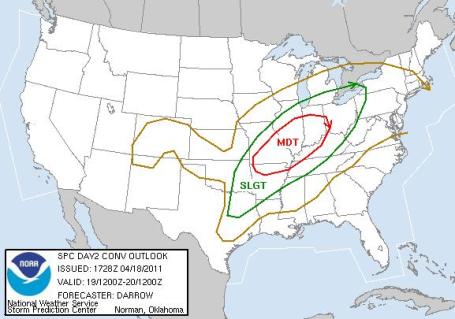
Another Tornado Outbreak Today? According to
SPC there is a moderate risk of tornadoes from St. Louis and Memphis to Louisille and Indianapolis. Winds aloft are unusually strong, another atmospheric scuffle brewing between tropical air from the Gulf of Mexico and cooler, drier air over the Great Lakes capable of creating supercell storms later today.
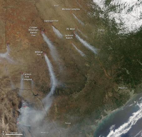
A Perfect Storm For Wildfires. NASA's Earth Observatory has an
update on the massive fires engulfing much of the Lonestar state, the result of severe drought, tinder-dry humidity levels and high winds: "
Since April 6, more than a million acres have burned throughout the state of the Texas, according to the Texas Forest Service. This image, taken by the Moderate Resolution Imaging Spectroradiometer (MODIS) on NASA’s Aqua satellite, shows conditions on April 15, 2011. Wind whipped both smoke and dust southeast across the state. The fires detected by MODIS are marked in red. The image illustrates one of the primary reasons fire danger is extremely high in Texas: strong winds. Warm temperatures, dry vegetation, and low humidity are also contributing to hazardous fire conditions. Normally a rainy month, March 2011 was the driest March on record, said the Texas Forest Service. Plentiful rains in 2010 spurred grass and shrubs to grow. The recent lack of rain, warm temperatures and low humidity has turned all of that vegetation into dry tinder, creating unprecedented fire danger. As of April 18, at least 23 large wildfires were burning in Texas. Seven of the largest are labeled in the image."
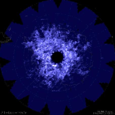
Clouds, Clouds Burning Bright. NASA has the first
composite photo of rare noctilucent clouds over the South Pole. A possible connection exists betweent the frequency of these high-altitude, luminous clouds, and climate change: "
High up in the sky near the poles some 50 miles above the ground, silvery blue clouds sometimes appear, shining brightly in the night. First noticed in 1885, these clouds are known as noctilucent, or "night shining," clouds. Their discovery spawned over a century of research into what conditions causes them to form and vary – questions that still tantalize scientists to this day. Since 2007, a NASA mission called Aeronomy of Ice in the Mesosphere (AIM) has shown that the cloud formation is changing year to year, a process they believe is intimately tied to the weather and climate of the whole globe. "The formation of the clouds requires both water and incredibly low temperatures," says Charles Jackman, an atmospheric scientist at NASA's Goddard Space Flight Center in Greenbelt, Md., who is NASA's project scientist for AIM. "The temperatures turn out to be one of the prime driving factors for when the clouds appear." So the appearance of the noctilucent clouds, also known as polar mesospheric clouds or PMCs since they occur in a layer of the atmosphere called the mesosphere, can provide information about the temperature and other characteristics of the atmosphere. This in turn, helps researchers understand more about Earth's low altitude weather systems, and they've discovered that events in one hemisphere can have a sizable effect in another."
A Native Son Revitalizes His Paper. In case you missed
this story in the New York Times by David Carr, some encouraging trends at the Star Tribune (and it didn't happen by accident): "
In 2008, when I last saw Michael Klingensmith, he was sitting in a corner office on the 34th floor of the Time Warner building, one of three powerful executives who controlled Time Inc., the biggest magazine publisher in the world. It was the only company that Mr. Klingensmith, an M.B.A. from the University of Chicago, had ever worked for. After three decades, including stops at Sports Illustrated and Time, he was on the short list to become the next chief executive. When the job went to Ann Moore, he hung in for a while as executive vice president in charge of strategy and acquisitions. “It was a real job, it just wasn’t a very fun one,” he said. So in 2008 at the age of 55, he took early retirement. He could have gone to work at any publisher in Manhattan, but instead, after a short time as a consultant, he moved to Minneapolis to become the publisher of The Star Tribune. It wasn’t a move to Mister Rogers’ Neighborhood. The newspaper had been through years of upheaval, churning through bankruptcy, publishers and lots of layoffs. But what could have been a quixotic last fling has turned into something far more impressive: The Star Tribune is adding readers — the Sunday circulation grew 5.7 percent in the last audit and will most likely be up again a bit in the audit that will be out in few weeks — the business is making money and, get this, distributing money from its profit-sharing plan to its employees."
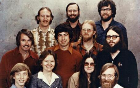
An "Unvarnished" Peek Into Microsoft's History. Did you see the 60 Minutes piece on Paul Allen? Fascinating; the parallels with Howard Hughes are unmistakable (as pointed out by Leslie Stahl). Here is a New York Times
summary of Allen's new book documenting his rough ride with Bill Gates. Fascinating stuff for any true techno-geek: "
In his autobiography, Paul G. Allen, the co-founder of Microsoft, portrays his role during the company’s early years as the visionary and technology strategist, while Bill Gates is presented as a brilliant business tactician. At one point in the book, which will be published on Tuesday, Mr. Allen describes Mr. Gates as a partner “who could take my ideas and magnify them.” At another point, Mr. Allen writes, “Our great string of successes had married my vision to his unmatched aptitude for business.” Nevertheless, Mr. Allen denied, in an interview on Friday, that the book was an effort to swing the pendulum of history in his direction, to claim more of the credit for critical decisions at the birth of the personal computer industry. “I just think this is my side of the story told in an unvarnished, warts-and-all way,” Mr. Allen said. Fiery confrontations between Mr. Allen and Mr. Gates drew considerable attention last month after an excerpt of the book was published in the May issue of Vanity Fair and on the magazine’s Web site. The clashes came over product decisions, hiring plans and their shares in the young company."

If You're Not On Facebook It's Time To Get Over Yourself. You probably run into a few sanctimonious people who have yet to get onto FB, and who pride themselves on being (luddites) and refusing to join the social media experiment. Sam Biddle from Gizmodo takes them on in
this post:
"Oh, yeah, I'm not on Facebook. Like, it's so invasive. If you've said anything like this, I feel bad for you. Facebook has over half a billion users. Almost everyone I know uses it. I use it. You probably use it. But ubiquity isn't equal to universality. Everyone knows one of those self righteous Facebook abstainers. Social media luddites. Pushing aside modern society in favor of a purer lifestyle, devoid of pokes, tags, and feeds. Defenders of something more natural and independent than Zuckerberg's friendship hive. Except really, these people aren't defending anything except antisocial, extremely annoying behavior. And if you're one of them—you need to stop. I will grant you this: Facebook, much like Twitter, has a lot that sucks about it. A tremendous amount. You're exposed to inane human behavior on a scope and volume unprecedented in the history of mankind. And yes, there are privacy eyebrow-raises that are warranted—it's a little weird that people I barely know anymore see where I work, where I live, and who I'm talking to."

I'm suddenly feeling very inadequate with my single touch-screen iPhone 4. Definite smartphone-envy. A
post from gizmag.com: "
Kyocera's dual-touchscreen Echo smartphone is now available through Sprint in the U.S. The standout feature of the Echo is the extra screen real estate provided by the two 3.5-inch WVGA touchscreen displays connected by a pivot hinge that allows the device to be used in the traditional single screen configuration or folded out so each display can be used independently, side-by-side or combined to form a 800 x 960 pixel 4.7-inch display – albeit divided by a black bar formed by the frame."
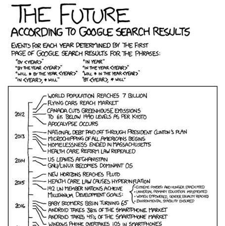
The Future According To Google Search Results. Someone has entirely too much free time, but the results are interesting. Click
here (to waste more time).
The T-Mobile Royal Wedding. O.K. This 2:13
YouTube clip has gone viral, nearly 5 million views, and it is funny. I have to give T-Mobile credit for poking fun at the "Royals", and creating a little more interest in the brand as well. This is what I'd LIKE to see this upcoming weekend on CNN, but I have a hunch the real deal will be considerably more restrained: "
Watch the wedding entrance dance to top all wedding entrance dances. T-Mobile's Royal Wedding Dance celebrates the marriage of William and Kate with the help of a host of royal look alikes and music from East 17! T-Mobile wishes William and Kate a long and happy marriage. Join our Facebook group http://www.facebook.com/tmobileuk."
 Calm Before The (Slush)
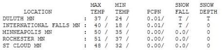
. Under a gray sky the mercury only reached 32 at Grand Marais, 37 in Duluth,
48 in St. Cloud and 50 in the Twin Cities. Statewide Monday temperatures were 10-15 degrees cooler than average with a trace of rain in Redwood Falls, .01" at International Falls.
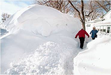
Could Be Worse. NO, we will not see
this much snow anytime soon.
Paul's Star Tribune Outlook for the Twin Cities and all of Minnesota:
TODAY: Cloudy and raw. A cold rain develops this afternoon, mixing with snow by the dinner hour. Winds: E 10-20. High: 41
TUESDAY NIGHT: Wet snow likely, starts to accumulate on lawns/fields. Low: 31
WEDNESDAY: Snow tapers to flurries, 1-2" for the metro. More south/east. High: 43
THURSDAY: Sun returns, snow quickly disappears. Low: 32. High: 50
FRIDAY: Warm enough aloft for rain. Low: 35. High: 47
SATURDAY: Damp start, slow PM clearing. Low: 37. High: 52
SUNDAY: Nicer day, feels like spring again! Low: 38. High: 61
MONDAY: PM showers, thunder? Low: 41. High: near 60
Weather Amnesia
Only Siberia has more weather extremes than Minnesota and the Dakotas. Then why do we stay? Denial. "Hey, the climate is warming, it's all good!" That, and amnesia. I think we're all hard-wired to forget the atmospheric trials & tribulations. The weather unites us, gives us something to talk about, other than Joe Mauer's flu, tax reform or a new Vikings stadium.
Exhibit A: April snow. "You're telling me my GREEN lawn is about to get shellacked with snow?!!" Yes, but it won't be that bad. Air temperatures close to freezing should keep freeways mostly-wet Wednesday morning. Some of the snow will melt on contact (soil temperatures are in the low 40s, if anyone asks).
Models suggest that the heaviest snow bands will set up south/east of MSP, with some 5-8" amounts possible for Rochester, but we should wind up with closer to 1-2" by Wednesday; maybe 3" closer to the Twin Cities (on lawns, fields and slow-moving robins). Whatever falls will melt within 24 hours. I promise. And I never promise anything (except sunrise and sunset).
Rain returns Friday; Sunday the sunnier day of the weekend. 60s pop up next week, before another big storm the middle of next week (probably rain).
Within 72 hours we'll look back & wonder, "Did it really snow?" Um, what snow?
NASA Study Predicts More Severe Storms With Global Warming. I thought it might be timely to call up an
MSNBC article from 2007. Climate scientists have been predicting this for some time now: "
NASA scientists have developed a new climate model that indicates that the most violent severe storms and tornadoes may become more common as Earth’s climate warms. "Previous climate model studies have shown that heavy rainstorms will be more common in a warmer climate, but few global models have attempted to simulate the strength of updrafts in these storms. The model developed at NASA’s Goddard Institute for Space Studies by researchers Tony Del Genio, Mao-Sung Yao, and Jeff Jonas is the first to successfully simulate the observed difference in strength between land and ocean storms and is the first to estimate how the strength will change in a warming climate, including “severe thunderstorms” that also occur with significant wind shear and produce damaging winds at the ground. This information can be derived from the temperatures and humidities predicted by a climate computer model, according to the new study published on August 17 in the American Geophysical Union’s Geophysical Research Letters. It predicts that in a warmer climate, stronger and more severe storms can be expected, but with fewer storms overall."
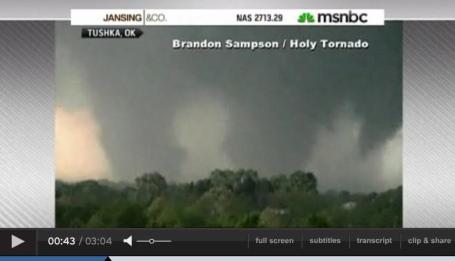
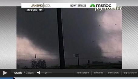
Why The Spike In Tornadoes? MSNBC has a
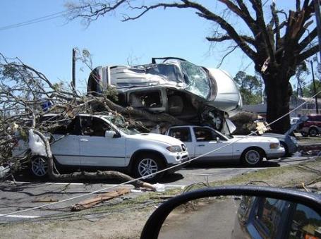
video focusing on the sharp increase in not only the number of tornadoes observed so far in 2011, but the intensity - far more EF-3 and EF-4 tornadoes than usual. A coincidence? Maybe. But I wouldn't take that bet. Again, no one storm, outbreak or even season can be linked to climate change. The reality: an increase in atmosphere temperature has evaporated more water into the air. More water vapor overhead may be "loading the dice" in favor of more numerous extreme weather events. Top image of a "multi-vortex tornado" from Tushka, Oklahoma, bottom image of a "wedge tornado" from Jackson, Mississippi.
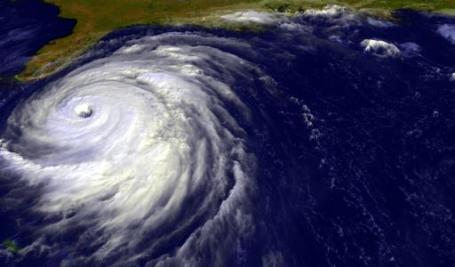
Hurricanes Worsen: Is A Warmer Earth To Blame? The Philadelphia Enquirer
examines a growing debate in the meteorological community: the number of hurricanes does not seem to be increasing, but the hurricane that do develop seem to be getting more intense over time. A fluke, or a trend? "The simmering issue of whether a warmer world brews more-destructive hurricanes is a powerful one, not just for coastal interests but for every U.S. taxpayer from Philadelphia to Honolulu. Look for the debate to heat up this year, as the latest outlooks are calling for another busy and potentially destructive hurricane season, which will begin June 1. Without question, hurricanes have become more devastating as the world has become warmer during the last 30 years. But are the trends related? Human activity indisputably is a factor - for evidence, see all that nature-taunting coastal building. The greenhouse case, however, remains arguable. A word on the warming: It's been real. Global temperatures have been above long-term averages every month since February 1985, according to National Climate Data Center records dating to 1880. They are just under a degree Fahrenheit higher now than they were when the trend started. As for the hurricanes, a warming trend also has taken hold in the storm-inciting waters of the tropics, and a 2008 study found rather convincingly that peak winds of the strongest hurricanes have intensified since 1981.
. Reuters has the
story: "
A better monitoring network for greenhouses gases is needed to warn of significant changes and to keep countries that have agreed to cut their emissions honest, scientists said in papers published Monday. "What we're hoping to do is see if the warming is feeding the warming, particularly in the Arctic," said Euan Nisbet, a specialist in methane emissions at the University of London. "Our monitoring network is very, very limited. We feel more observation is needed." Such measurement could warn of possible climate tipping points, scientists said in papers published by Britain's science academy, the Royal Society. The data also could be used to verify countries' reporting of greenhouse gas emissions against targets under the present Kyoto Protocol and a possible successor after 2012. The Earth's climate in the past has changed in a relatively short period of time, warming rapidly about 12,000 years ago at the end of the most recent glacial period. Scientists are not sure why that happened, and have warned of possible climate tipping points from manmade emissions."
On Climate Change The GOP Is Lost In Never-Never Land. A timely
editorial in the Washington Post: "
The climate change denialism is a newer part of the catechism. Just a few years ago, leading Republicans — John McCain, Sarah Palin, Mitt Romney, Newt Gingrich and Tim Pawlenty among them — not only accepted global warming as real but supported some kind of market-based mechanism to raise the cost of burning fossil fuels. Now polls show declining numbers of Republicans believing in climate change, and a minority of those believing humans are at fault, so the candidates are scrambling to disavow their past positions. Palin, who as Alaska governor supported efforts to limit greenhouse gas emissions, in 2009 wrote in The Post, “But while we recognize the occurrence of these natural, cyclical environmental trends, we can’t say with assurance that man’s activities cause weather changes.” Pawlenty similarly acknowledged on “Meet the Press” last year that “the climate is changing,” but added that “the more interesting question is how much of that is man-made versus natural causes.” When I asked last week how Pawlenty would answer that “interesting question,” his spokesman responded by e-mail: “We don’t know [the] cause of climate change.” Climate science is complex, and much remains to be learned. But if you asked 1,000 scientists, 998 of them would say that climate change is real and that human activity — the burning of oil, gas and coal — is a significant contributor. But Pawlenty’s supposed uncertainty is convenient, because if we don’t know the cause, then there’s little point in looking for a cure. And any cure is going to cost money, or votes, or both."
The Science Of Why We Don't Believe Science. Chris Mooney at Mother Jones has an
eye-opening article about why we accept some scientific data as "truth", while denying other scientifically-accepted information. It all comes down to how our brains are hard-wired: "
The theory of motivated reasoning builds on a key insight of modern neuroscience (PDF): Reasoning is actually suffused with emotion (or what researchers often call "affect"). Not only are the two inseparable, but our positive or negative feelings about people, things, and ideas arise much more rapidly than our conscious thoughts, in a matter of milliseconds—fast enough to detect with an EEG device, but long before we're aware of it. That shouldn't be surprising: Evolution required us to react very quickly to stimuli in our environment. It's a "basic human survival skill," explains political scientist Arthur Lupia of the University of Michigan. We push threatening information away; we pull friendly information close. We apply fight-or-flight reflexes not only to predators, but to data itself. We're not driven only by emotions, of course—we also reason, deliberate. But reasoning comes later, works slower—and even then, it doesn't take place in an emotional vacuum. Rather, our quick-fire emotions can set us on a course of thinking that's highly biased, especially on topics we care a great deal about. (Bottom Line: We apply fight-or-flight reflexes not only to predators, but to data itself.)"
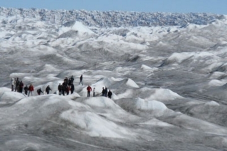
NOAA Joins International Effort To Track Black Carbon In The Arctic. The concern? Black carbon lowers the albedo of Arctic ice, accelerating melting, which further warms the air, sparking more warming - an example of "positive feedback" that is increasing the rate of ice melt up north. NOAA has the
details: "
Six nations are participating in a study that looks at the potential role of black carbon, or soot, on the rapidly changing Arctic climate. NOAA is using two small unmanned aircraft the size of a large suitcase outfitted with sensors to sniff and sample the air. The Arctic climate is changing faster than some scientists expected. A continuing decline in summer sea ice, warmer temperatures, changes in vegetation, and other indicators signal polar changes that affect the rest of the globe. Black carbon is contributing to this warming. Scientists say much of the black carbon in the Arctic comes from biomass and fossil fuel burning in North America and Eurasia. “Carbon is dark in color and absorbs solar radiation, much like wearing a black shirt on a sunny day. If you want to be cooler, you would wear a light-colored shirt that would reflect the sun’s warmth,” said Tim Bates, a research chemist at NOAA’s Pacific Marine Environmental Laboratory (PMEL) in Seattle and co-lead of the U.S. component of the study. “When black carbon covers snow and ice, the radiation is absorbed, much like that black shirt, instead of being reflected back into the atmosphere.” Also participating in the Coordinated Investigation of Climate-Cryosphere Interactions (CICCI) project are scientists from Norway, Russia, Germany, Italy and China. The goal is to coordinate more than a dozen research activities so they are done concurrently providing, for the first time, a vertical profile of black carbon’s movement through the atmosphere, its deposition on snow and ice surfaces, and its affect on warming in the Arctic."
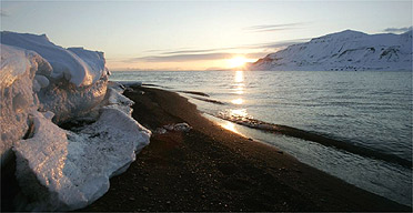
Climage Change Retreating Arctic Coastline By Half A Meter Every Year. Here's a
story from dnaindia.com: "
Climate change and increased erosion are retreating the Arctic coastline by half a metre every year, according to a new study by more than 30 scientists from 10 countries. This implies substantial changes for Arctic ecosystems near the coast and the population living there. The researchers investigated over 100,000 km and thus a fourth of all Arctic coasts and have published their results for the first time. The changes are particularly dramatic in the Laptev, East Siberian and Beaufort Seas, where coastal erosion rates reach more than 8 metres a year in some cases. Since around a third of the world's coasts are located in the Arctic permafrost, coastal erosion may affect enormous areas in future. Up to now they have been protected against the eroding force of the waves by large sea ice areas. Due to the continuous decline in sea ice, this protection is jeopardised."
Budget Fight Hurts U.S. Climate Effort. We're only interested in protecting the environment and responsible development when the economy is in good shape? Really? An
update from the New York Times: "
AUSTIN, TEXAS — The recent budget wrangling in Washington will take a toll on the administration’s efforts to combat climate change. The budget of the U.S. Environmental Protection Agency was cut $1.6 billion — 16 percent — for the rest of this fiscal year, under the bill that President Barack Obama signed Friday. Other programs, like international forest-protection efforts, will also get less financing than their advocates had hoped. But with Republicans determined to rein in the E.P.A., environmentalists say, things could have been worse. Bigger clashes may be coming, as Congress draws battle lines over the budget for the next fiscal year. The largest cuts to the E.P.A., which is the main environmental regulator in the U.S. government, will affect local programs, like the money the agency disperses to states to improve their wastewater treatment and drinking water facilities. But some cuts will affect climate-related programs. S. William Becker, the executive director of the National Association of Clean Air Agencies, which represents state and local government regulators, said that states would receive $25 million less than the Obama administration had sought for the remainder of this fiscal year to implement the administration’s greenhouse gas programs. The E.P.A. began to regulate emissions of the gases in a limited way in January, and it plans to phase in additional requirements over time."
Physics Trumps Right Wing Ideology. For the record (not that anyone really cares), I've voted as a Republican for just about my entire adult life, but lately I've been embarrassed by the growing willingness of many of my right-wing friends and colleagues to deny climate science and look the other way. If 97% of doctors gave you the same diagnosis - chances are you'd listen to them and take action, but that apparently doesn't apply to climate scientists. The political process has become increasingly corrupted by energy lobbyists and fat campaign contributions to the point where my party is unrecognizable (at least to me). It makes me sad, it makes me angry. Our kids and grandkids are going to be pretty upset; they'll want to know what we knew - when - and what we did about it. Here's a
post that sums up my current level of frustration about climate denial as a political art-form: "
Global warming deniers know as much about climate science as they do about brain surgery. Would you let them tell your doctor what to do about that tumor? Why do I–a professional physicist and lifetime member of the American Physical Society–accept the reality of human-caused global warming? Because I accept the following top-ten list of physics facts, which have never been disputed in the scientific literature. This is also why the American Physical Society of 47,000 physicists says “The evidence is incontrovertible: Global warming is occurring”.
PHYSICS FACT #1: The atmospheric carbon dioxide concentration has increased rapidly since the beginning of the industrial revolution, after being nearly constant for thousands of years.
PHYSICS FACT #2: The surplus carbon dioxide has an isotope composition that can only come from fossil fuels. The increase in concentration is not natural; it comes from human activities.
PHYSICS FACT #3: The radiative properties of carbon dioxide have been measured by physicists in the laboratory: It absorbs thermal infrared (heat) radiation.
PHYSICS FACT #4: Because carbon dioxide has this heat-absorbing physical property, the increase in its concentration has increased the infrared opacity of the Earth’s atmosphere and blocks the outward radiation of heat."
Europe's Largest Ecological Catamaran Takes Sail. Here's an interesting
article from gizmag.com: "
It may be 24 meters (79 feet) long, 10.5 meters (34.5 feet) wide and be able to carry up to 150 passengers, but the Eco Slim seagoing catamaran produces less of a carbon footprint than vessels much smaller than itself. There are two main reasons for this – its electric motors, which are powered by several onboard renewable sources, and its lightweight, streamlined hull, that allows it to move through the water using a minimum amount of energy. Created by Spain's Drassanes Dalmau shipbuilders and launched on March 31st, it's officially Europe's largest "green" catamaran."


No comments:
Post a Comment