Storm fizzles:
too much dry air (at the surface and aloft) for accumulation close to the metro area.
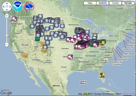
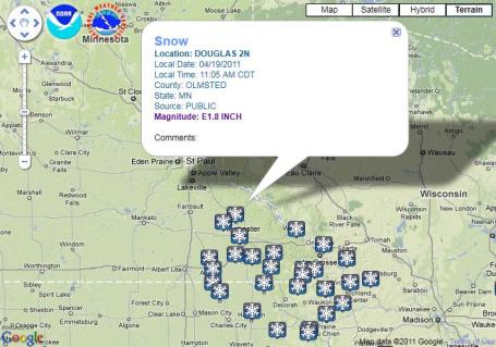
2-7" snow reported across far southeastern Minnesota, closer to Winona, Rochester and La Crosse.
8.7" snow reported in Green Bay, WI Tuesday, the greatest daily snowfall so late in the season. 91.2" for the season, snowiest since 1889-90.
Slushy Coating to Inch or Two possible on some lawns/fields this morning - any snow will melt within an hour or two.
Sunday:
nicer day of the weekend with highs near 60; a more springlike pattern returns early next week.
T-storms possible by Monday/Tuesday of next week.
Slight chance of a severe storm outbreak close to home by Tuesday.
It Did Snow - Just Not Here. Austin, Minnesota picked up 3.8", with 4.4" reported at Peterson, in Fillmore County, far southeastern Minnesota. Rochester saw nearly 4", with over 8" in the La Crosse area.
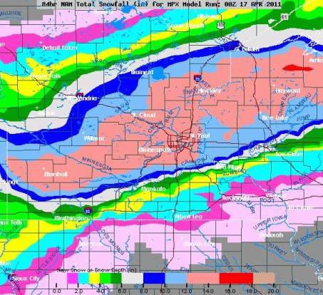 "NAM" Snowfall Forecast, Issued Midday Sunday
. This is the raw data we were looking at Sunday, hinting at a major snowfall for the Twin Cities.
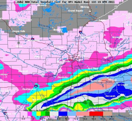 "NAM" Snowfall Forecast, Issued Tuesday Afternoon
. The reality of numerical weather prediction: there will always be changes and gyrations from model run to model run. As newer, more accurate and reliable data initializes the supercomputers and we get closer to the actual storm event the accuracy should (in theory) improve dramatically as we get closer to the storm. But I've never seen the models off by this much in the span of just 48 hours. It's a trend I've noticed in the U.S. models since late February. A bit of a meteorological mystery...
 Anatomy of a Bust.
 It's too easy, and something of a cop-out, to shrug your shoulders, point to the weather models, and blame the computer simulations we use day-in and day-out. The best forecasts take advantage of computer models, historical perspective, and common sense.
Much of the challenge is knowing which model (if any) to believe! Maybe it's just my imagination, but I've noticed a gradual degradation in the models ever since late February; they're just far more unreliable than they were back in December, January and early February, when the models did a pretty good job helping us nail a few (major) snowstorms. Since then it's been all downhill, and I'm at something of a loss to explain why. Is it the transition from a wintry regime to a more springlike pattern, a change in the physics of the models (which does take place) that makes them less accurate for winter-type, cold-core snow/ice events in April? That's one possible explanation: that we're running a summer model, while the pattern is still locked in a March-like pattern. The other explanation: cuts at NOAA? I have heard nothing about cuts in staffing or operations at NCEP, the National Centers for Environmental Prediction, based at Camp Springs, MD. I'm not a conspiracy theorist - I have to believe if there were (significant) changes to the models (or layoffs) we would have heard something through official channels. It's a real head-scratcher. As recently as Sunday the (usually reliable)
NAM
model was hinting at 12-15" for the Twin Cities. Within 2 days the NAM went from over a foot to less than an inch. You don't see those kinds of gyrations (within 2 days of the arrival of a storm) very often.
If it weren't for weather models we'd be hard-pressed to make any kind of forecast beyond 36 hours. We absolutely rely on them to get any kind of handle. Looking at current data only gets you so far. But something is going on - the European ECMWF model is performing admirably (with this last "storm" it correctly kept the heaviest precipitation shield well south of Minnesota). The U.S. models are underperforming, and I'm at a loss to explain why.
Dodging A Bullet. We've been VERY lucky in recent weeks, all things considered. A couple of potentially major snowfalls fizzled, early model fears did not pan out, we've only seen a few dribs and drabs of snow so far in April. And the potential for record flooding never quite materialized. Two major factors at work here: a lingering La Nina (cooling of equatorial Pacific Ocean water) kept us cooler than average much of March and early April. That slowed the rate of snow melt. In addition Minnesota avoided heavy rain events, no 1-2" rainfalls in recent weeks. That amount of rain falling on frozen ground (with lingering snow up north) would have accelerated snow melt, and made a bad flood season much worse. So in a strange way our annoyingly cool spring was a blessing, at least for anyone living along Minnesota's streams and rivers.
Avoiding A Worst-Case Minnesota Flood Scenario. I asked Dan Luna about the flood season, and why record floods never materialized. Here is his response: "
As far as the NWS terminology goes, we had major flooding at most river locations. So in our minds we did have a major flood, just not a record flood. We still have concern though for the next month or so."
Luna goes on to add "Basically a hydrograph represents a volume of water. If you drive by the Miss/Mn rivers they are still very high and have been for 4 weeks. If we had not had the cold weather, we would not have stopped the melt, and the water would have continued flowing to the main river channels all at once. By stopping the melt we kept the river from coming up any higher and ultimately prolonged the high levels (what we are seeing now). So back to the hydrograph...the volume of water is what we expected. The only other factor which relates to river height would be the duration of the hydrograph. If the the volume is forecast and is what we expected, and it occurs over a 28 day period and we change the duration to a 20 day period or shorter...what happens? If volume is conserved, the peak or river height must go up. That is what did not happen. The volume is what we expected. Typically we do not see these high levels for such a long period unless we experience substantial rainfall, which we did not."

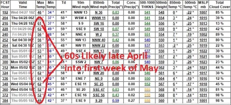
. I asked Pete Boulay, over at the Minnesota State Climatology Office, about the last time we had a late April snowfall in the Twin Cities. I've been trying to block those slushy memories, but he refreshed my (senior) memory:
"That would be 2002 where the Twin Cities saw 5.5 inches of snow on April 27th (during the evening) and .5 on the 28th."
"Looking in past history for the Twin Cities measurable April snow falls on about 1/3rd of the Aprils past the 15th. Usually it is only an inch or two, but occasionally there is a larger storm like in 2002."
Thanks Pete. Yes, it's been a disappointing spring so far - but things could be considerably worse.
Experimental Local Storm Reports Google Map Display. Now there's a mouthful, but the San Diego office of the National Weather Service has done a great job with a very cool information-mash-up. Current storm reports on top of an interactive Google Map. Click
here to see for yourself.
Will Spring "Stick" This Time? I think so, yes. It's been a forgettable spring, temperatures trending cooler, but at least we haven't been rocked with mega-snows, hail or tornadic storms. The pattern is finally beginning to shift, the jet stream migrating northward, pulling warmer air (and a growing thunder threat) with it. The GFS is hinting at a string of 60-degree highs from late April into the first few days of May. Yes, it would be nice to put away the winter clothing.
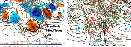
Potential For Severe Storms? It's early to be speculating about something 6 days away. You would think I would have learned my lesson (after this last psuedo-storm). But I guess it's human nature to look ahead, do the best we can with the (often limited) tools at hand. If there's one lesson to be learned in this last (fizzling/disappointing) storm, it's that the European ECMWF seems to do a consistently better job than the (U.S.) GFS or NAM models. I've heard this from other meteorologists, and I'm starting to see the light. The only problem: ECMWF data is not in the public domain - the Europeans charge (exhorbitant) fees to access the complete model data set. We can only see bits and pieces, a subset of the model, but it's enough to give us a glimpse of what may be to come. By Tuesday of next week the ECMWF predicts a negatively tilted trough of low pressure aloft, implying strongly diverging air aloft, a vigorous warm frontal boundary pushing into southern Minnesota. That COULD set the stage for strong to potentially severe storms by Tuesday afternoon of next week. We'll see.
. PBS has the
story: "
After deadly tornadoes pummeled states across the South and Midwest over the weekend, emergency workers assessed the devastation and continued to search for victims on Monday. Gwen Ifill discusses the storm's aftermath with David Schrader of the American Red Cross."
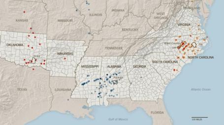
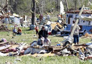
Experts Busy Assessing Ferocity Of Storms. The tornadoes that slammed into North Carolina and Virginia were especially fierce, according to NWS personnel dispatched to track and summarize the damage paths. It's now believed that 6-8 "supercell" thunderstorms may have dropped as many as 15-20 tornadoes, some EF-3 and EF-4 in strength. This is often the case, "families" of tornadoes forming under the same parent thunderhead.
More from the New York Times: "
Amid the stunned residents, bleary-eyed insurance adjusters and solicitous relief officials who traipsed through storm-damaged homes and businesses Monday was a small cadre of meteorologists tasked with figuring out just how many tornadoes touched down and how powerful they were. Jeff Orrock, a warning coordinator at the National Weather Service, spent Sunday and Monday talking his way past emergency officials in North Carolina so he could perform tornado assessment — a mundane task that is important in improving the ability to forecast such storms and warn people to take cover. His inspection of the State Employment Security Commission building in Roanoke Rapids, N.C., helped to show just how powerful the storms were miles beyond hard-hit Raleigh."
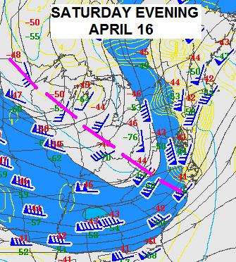
A Tornado-Producing "Machine". The Weather Channel's Stu Ostro has a
good explanation of the meteorological ingredients necessary to produce a super-outbreak similar to what America experienced last weekend, the dangers of a "negatively-tilted trough": "
Those upper-level jet stream maps, by the way, have some similarities to the pattern present for big outbreaks last May in Oklahoma, April 1998 in the Deep South, and March 1984 in the Carolinas ... except this time it happened on three consecutive days. With this kind of dip, the jet stream energy tends to really punch over the warm, humid, unstable air ahead of it, conducive to severe storms. Also, the air ahead of the trough spreads widely apart in upper levels of the atmosphere (a particularly vivid example of which is above, as I illustrated on the Friday map with the arrows that follow along with the wind flags), which helps lead to thunderstorm development as air rises to take the place of the air evacuated above. [There's a whole separate technical topic of "diffluence" vs. "divergence," but that's beyond the scope of this blog! Readers who are interested in learning more about that can find a quick tutorial here.] Then, with the right combination of other ingredients such as winds at different levels of the atmosphere blowing in different directions, tornadoes can form. Those ingredients were also strongly present on Thursday, Friday, and Saturday."
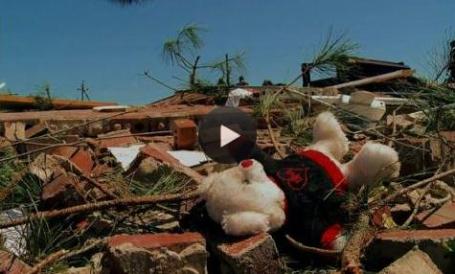
Massive Tornado Outbreak From OK to NC: Why So Big? Meteorologist Jon Davies has
another perspective on the meteorological parameters present last Friday and Saturday, able to generate long-lasting, violent tornadoes: "
The tornado outbreak last Thursday-Friday-Saturday across the south central into the southeastern U.S. and mid-Atlantic states was pretty eye opening (see photos above). Sadly, more than 30 people died in tornadoes, and there were at least 45 deaths over all from a very strong severe weather system on a 3-day tear. Why so big an outbreak? The 500 mb forecast charts above show a dynamically intense, broad trough in the mid-levels moving from the central into the eastern U.S. during those 3 days, providing plenty of upward "forcing" in the atmosphere. Most of the tornadoes occurred toward the southern end of the system with plentiful moisture (not shown) available from the Gulf and Atlantic. Also on the 500 mb maps above, notice how the mid-level flow intersected the blue lines of storm initiation and orientation at a larger angle toward the southern end of the activity each day, often around 70 deg rather than 10-30 deg seen father north. This orientation of the mid-level flow aloft relative to the surface activity tended to make for more discrete and individual supercells in those areas, probably helping the generation of tornadoes. Low-level storm-relative helicity (SRH, not shown) was also very high in these areas, with values of 600-700 m2/s2 (!!!) from AL to NC during the last 2 days of the outbreak. This helped to support strong tornadoes in environments where MLCAPE was less than 1500 J/kg."
Deadly Twisters Renew Questions About Pressures On Emergency Budgets. Many states are cutting their budgets for emergency response - and it's coming at a bad time, as
reported by the New York Times: "
ATLANTA — Emergency management officials in Southern states said recent budget cutting did not limit their ability to respond to the scores of tornadoes that touched down in six states on Friday and Saturday, leaving at least 44 people dead, injuring hundreds and causing devastating damage to houses, businesses and farmland....Nationwide, even as states have slashed their budgets in consecutive years, spending on state emergency management systems has actually increased slightly, according to the National Emergency Management Association. The accumulated budgets of those agencies in the 50 states and the District of Columbia totaled $316.8 million in the 2010 fiscal year, up from $294.3 million in 2009."
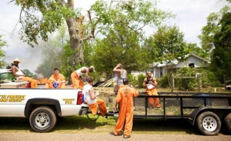
When Disaster Strikes, Help Neighbors Dig Out. Here's an excerpt of an
editorial from the Charlotte Observer: "
There are practical lessons, too, from Saturday's storms. In an era of a warming globe, we must expect and prepare for more extremes of weather - not just hotter temperatures but also more violent storms that cause more damage. This should be of particular concern as the state's and the nation's infrastructure - roads, bridges, water and sewer systems and other structures - continues to age without adequate maintenance. The storms should also remind us about the foolhardiness of building in harm's way, especially along the coast, as sea levels rise and as land erodes. In particular they should remind us about the importance of effective building codes that require residences in potentially hazardous zones to be built to withstand high winds and other forces of nature. State lawmakers should strongly oppose any attempts to weaken those regulations. The storms also require us to reflect on our personal responsibilities as good citizens: Make emergency plans should tornadoes, hurricanes or earthquakes occur. Have on hand at least minimal nonperishable food and water supplies as well as other gear that might be needed. And find the time to lend a hand, make a donation, or help feed or shelter a newly homeless neighbor."
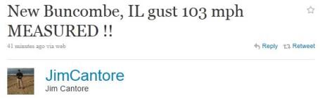
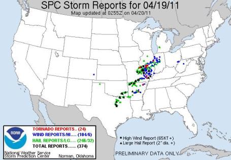 Another Outbreak
. As of 10 pm Tuesday night 24 tornadoes had been observed, most of them in Illinois. Details from SPC
here.
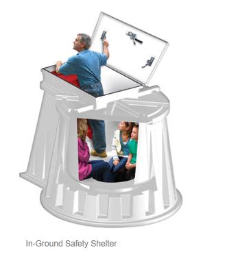 Tornadoes Prompt Run Of Phone Calls To Storm Shelter Companies
. I'm always amazed by the number of people living in Tornado Alley, or "Dixie Alley" (Mississippi and Alabama to Tennessee) who don't have basements, for a variety of reasons: expense, too much bedrock making excavation prohibitively expensive. USA
Today has
story about companies with a solution to deadly, tornado-force winds: "
The wave of tornadoes and storms that brought death and destruction across the South and Mid-Atlantic has triggered another surge: inquiries to companies that specialize in storm shelters. Phones at Granger Plastics Co. of Middletown, Ohio, which makes in-ground storm shelters, lit up Monday morning and calls haven’t stopped. “When you go though a weekend like this, you realize how much damage these storms can do,” says Alli Cravens, Granger’s marketing manager. Even at $5,000-$6,000 a pop for a five-person shelter, installation extra, callers are unfazed, she says: “Our website had its busiest day Sunday.” The calls are an understandable reaction to tornadoes from Thursday through Saturday, killing at least 46 people in six states. And with the National Weather Service forecasting more severe weather from Texas to the Great Lakes through today, the calls aren’t likely to abate. The Granger shelters (photo above) are just over 5 feet high and 5 feet across and designed to be buried underground, fit five adults “or more in a real emergency,” Cravens says. They take a half-day to install."
 Life Insurance
. I've said it before: NOAA
Weather Radio is an amazingly (affordable) form of life insurance: $30-50 buys you a radio that turns on (automatically) in the middle of the night if a tornado warning is issued for your county. No other device will do that. For people living in mobile homes a shelter like the one above, built by
Granger, is a good option. Costs vary, but for $3-6k you can have an in-ground shelter that installs in a garage, or in your yard - one that WILL
protect you in the event of a tornado.
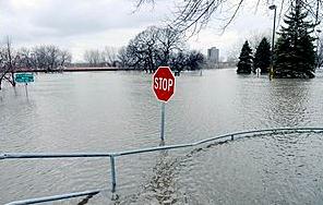
Floodwaters Forcing Closures Along Mississippi. Accu Weather meteorologist Bill Deger has an
update on flooding along the Mississippi River, well downstream of St. Paul: "
As waters continue to swell along the Mississippi River, officials are warning residents and closing roadways in anticipation of a crest soon in some areas. Homes and businesses along the river from near Dubuque, Iowa, to the Quad Cities are stacking sandbags and preparing for the worst as river levels are expected peak this week. Many nearby roadways have been closed due to high water, with officials taking precautionary measures to protect vehicles along roads and bridges in danger of being impacted. The Savanna-Sabula bridge, an important thoroughfare that connects northern Illinois with central Iowa, was closed on Monday night. The worry that debris could strike the underbelly of the bridge led to the closure, leaving drivers to deal with a much longer commute around the bridge."
 657 New Islands Discovered Worldwide
. As our tools improve, new discoveries mount, from a sub-atomic level to distant galaxies. It would seem that there are some islands out there that have never been accurately documented, until now. Here's an excerpt of a
story from Live Science: "
Here's something you don't see every day — hundreds of new islands have been discovered around the world. The Earth has 657 more barrier islands than previously thought, according to a new global survey by researchers from Duke University and Meredith College in Raleigh, N.C. The researchers identified a total of 2,149 barrier islands worldwide using satellite images, topographical maps and navigational charts. The new total is significantly higher than the 1,492 islands identified in a 2001 survey conducted without the aid of publicly available satellite imagery Barrier islands often form as chains of long, low, narrow offshore deposits of sand and sediment, running parallel to a coast but separated from it by bays, estuaries or lagoons. Unlike stationary landforms, barrier islands build up, erode, migrate and rebuild over time in response to waves, tides, currents and other physical processes in the open ocean environment
."
* To see "
8 Of The World's Most Endangered Places" click
here, courtesy of ouramazingplanet.com.
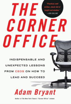
Distilling The Wisdom Of CEO's. I thought this was an
interesting article in the New York Times about the character traits necessary to be an effective CEO. Like the quarterback of a football team, a CEO can make or break a company. Truly good ones are few and far between: "
IMAGINE 100 people working at a large company. They’re all middle managers, around 35 years old. They’re all smart. All collegial. All hard-working. They all have positive attitudes. They’re all good communicators. So what will determine who gets the next promotion, and the one after that? Which of them, when the time comes, will get that corner office? In other words, what does it take to lead an organization — whether it’s a sports team, a nonprofit, a start-up or a multinational corporation? What are the X factors? Interviews I conducted with more than 70 chief executives and other leaders for Corner Office
in The New York Times point to five essentials for success — qualities that most of those C.E.O.’s share and look for in people they hire. The good news: these traits are not genetic. It’s not as if you have to be tall or left-handed. These qualities are developed through attitude, habit and discipline — factors that are within your control. They will make you stand out. They will make you a better employee, manager and leader. They will lift the trajectory of your career and speed your progress."
Why Twitter Might Be Ruining Your Love Life. Yes, this social media stuff is getting a little out of hand. People spend so much time posting updates on Twitter and FB, its amazing they have time to do their "work" and live their lives. Sam Biddle at Gizmodo takes on a
growing problem: addiction to the Twitter-Monster: "
A new series of studies out of OKCupid's data-crunching love labs reveal daily Twitter users have shorter relationships than those who don't—five to ten percent shorter. This makes sense. Twitter might turn us into more annoying, vain mates. Across all ages, the data—sampling over 800,000 OKC users—saw appreciable dips in relationship length among avid tweeters. So what's behind this trend? Does a fast-paced, wham-bam see ya never lifestyle just jibe with the 140 character interlocutor? Is it as simple as OKCupid cofounder Christian Rudder's assessment that "People who Tweet live their life in shorter bursts"? That's part of it. But it's not enough. Yes, the internet is probably ravaging our attention spans, and those used to expressing themselves (and absorbing the thoughts of others) in tiny fragments might prove to be statistically more frustrating partners than those who, I don't know, write long letters to each other? But there's more to the story of Twitter's finger in the eye of the average love life. Anything you use every day transforms you—gradually, slightly, yes—but profoundly."
 Don't Take Away My Cell Phone!
 The AP has a rather unsurprising
finding:
younger people would rather go without TV than their smart phones: "
Young people would rather give up watching TV than go without their mobile phones - for the first time since an annual media survey began. Ever since media regulator Ofcom began conducting its research in 2005, TV has consistently come top of the popularity stakes. But for the first time, 16 to 24-year-olds have said they would miss both their mobile phone (28%) and the internet (26%) more than TV (23%). Children aged between 12 and 15 are also more attached to their mobile - saying that they would struggle from not having a mobile (26%) more than TV and the internet (24%). For adults aged 16 and over, TV remains the medium that would be missed the most, but the figure has decreased from 50% in 2009 to 44% in 2010. Those aged 12 to 15 spend 17.2 hours each week watching TV - with time spent on the internet nearly catching up at 15.6 hours."
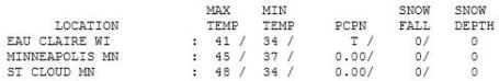
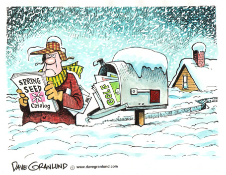
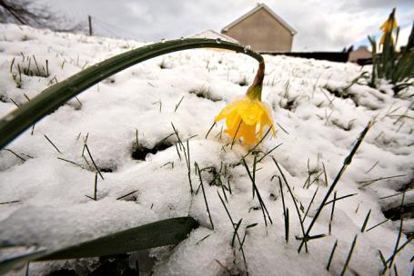
 Spring On Hold
. Under a gray, threatening sky, temperatures held in the 40s statewide, ranging from 41 at Eau Claire, WI to
48 in St. Cloud, 45 in the Twin Cities. That's a far cry from the average high of 59 in the metro area. By Sunday we should see a return to more springlike conditions, statewide.
 Paul's SC Times Outlook for St. Cloud and all of central Minnesota:
TODAY: A little light snow or flurries possible early (slushy coating - 1"), clouds give way to some PM sun. Winds: NW 10. High: 43
WEDNESDAY NIGHT: Mostly cloudy and cool. Low: 29
THURSDAY: Some sun, feels like spring again. High: 51
FRIDAY: Light rain likely, lawns "greening up". Low: 37. High: 49
SATURDAY: Damp start, slow PM clearing. Low: 36. High: 52
SUNDAY: Spring fever returns to Minnesota. Partly sunny and milder. Low: 38. High: 59
MONDAY: Periods of rain likely. Low: 42. High: 57
TUESDAY: Showers linger, PM thunder? Low: 45. High: near 60
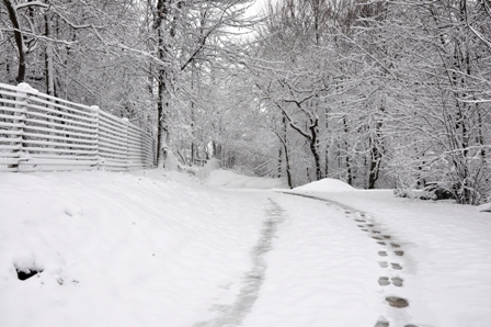
(Photo courtesy of Donncha O Caoimh at http://inphotos.org/)
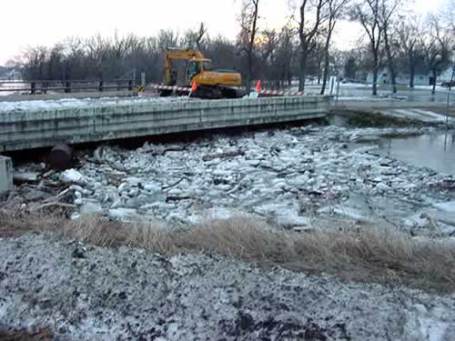
Fleeting Slush
The "storm" we've been tracking for nearly a week came limping into town overnight; any (minor) traces of slush in your yard will melt rapidly. Statistically this SHOULD be the last snow event for the Twin Cities, although with a persistent La Nina pattern I'm not sure I'd take that bet. Some 6"+ snowfall amounts are still possible closer to the storm track, from Rochester to Winona, but the metro area escapes with a candy-coating of slush on a few lawns & fields.
So what happened? Too much dry air in place (which, for whatever reason the models didn't catch). Snow was falling high overhead Tuesday afternoon/evening, but it evaporated before reaching the ground. The storm veered farther south/east, taking a track too far from MSP for significant snow close to home. The Dakots picked up 6-12" snows, with up to 10" across central Wisconsin, but a surge of dry air aloft snuffed out the storm as it lifted into central Minnesota. That said, far southeastern MN is waking up to some 2-7" amounts, closer to Winona and La Crosse, with 6-10" amounts streaking into central Wisconsin. No excuses: the models did a lousy job with this one, and so did we, continuing a pattern of "false positives" we've seen ever since early March. I have no idea why model performance is so bad with these snow scenarios. The very same models did a heroic job in December, January and much of February, but the transition to a spring pattern has left them especially unreliable. A few days ago ALL the models were hinting at a few inches. Then the GFS killed the storm Monday afternoon, whisking it south/east. In retrospect we were lucky to wind up with anything from this system.
Spring fever makes Minnesotans do strange and impulsive things. My friend & partner, Todd Frostad, lives on Lotus Lake, in Chanhassen. "A few days ago guys on a pontoon were breaking up the ice, so they could have water-skiing boasting rights," he said. Say what? "They had dry suits on, I saw them taking turns water-skiing on my way to work!" Impressive. Crazy. It confirms my suspicion that we're a state of Weather Warriors.
Skies brighten this afternoon, a little sun should boost the mercury to 50 tomorrow before a cold rain returns Friday. Skies dry out Saturday with a clearing trend; Sunday restores your faith in spring with highs near 60, before showers and T-storms slosh into town Monday. Slush to thunder in 5 days.
Supreme Court Hears Arguments In Global Warming Case. An
update from Huffington Post: "
WASHINGTON -- The Obama administration and leading power companies are going before the Supreme Court in an effort to block a global warming lawsuit aimed at forcing cuts in greenhouse gas emissions. The justices are hearing arguments Tuesday in the court's second climate change case in four years. A half-dozen states, New York City and three land trusts sued four private utilities and the Tennessee Valley Authority over emissions of carbon dioxide from plants in 20 states. The lawsuit says carbon dioxide, which is produced when coal, gasoline and other fossil fuels burn, is one of the chief causes of global warming. The administration and the companies say federal courts should not set environmental policy. The administration says the Environmental Protection Agency is developing regulations that would accomplish what the states are seeking."
10 Crazy Ideas To Combat Climate Change (That Just Might Work). Wellhome.com has a
few non-traditional ideas: "
A generation ago, the development of electric cars seemed like a novel, crazy idea in the effort to stop climate change. But as science gets closer to developing an efficient car, and as a number of hybrid vehicles begin to flood the market, it’s becoming apparent that what was crazy yesterday may be the next big idea in saving our environment tomorrow. Scientists have brainstormed a number of ideas that seem strange, wacky, and just plain weird to us now. These ideas range from simple steps that people are encouraged to make a part of their daily lives to trillion dollar endeavors that, at the moment, seem completely illogical. However, in another generation these ideas may be the next big leap in going green."
Met Office Chief Gets Death Threats From Climate-Skeptic Fringe. Here's a nice development. It's come to this? Here's the
story from tbd.com: "
Another day, another believer in manmade climate change marked for death. This time the target is John Hirst, head of the Met Office, which is like the British counterpart to NOAA. Hirst opened up about the threats during a recent talk at the University of Exeter. Oddly enough, he was discussing trying to reach out to a prominent climate skeptic, U.K. celebrity Johnny Ball, who reportedly has received death threats himself from climate-change believers. (Yes, the river of hate flows both ways.) "I wrote to Johnny and said: 'I get death threats too, it's crazy,” Hirst said. “'Why don't we talk, because if we can take some of this small 'p' politics out of this conversation we might do a service to the world.'" Hirst didn't mention specific threats, but judging from hate mail sent to climatologists in the past he might've been told to “gargle razor blades,” sink “6 feet under, with the roots” or simply stand inside his house while a yawning earthquake “swallows you into hell.” The skeptical fringe can be quite creative, when motivated."
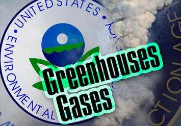 U.S. Greenhouse Gases Drop To 15 Year Low
. One rare silver lining to the worst recession/downturn in 65 years?
Details from Fox News: "
A slow economy and less demand for energy caused the U.S. to emit a smaller volume of greenhouses gases in 2009 than in any year since 1995, according to a government report released Wednesday. The drop in emissions was due primarily to less demand, but changes in coal and natural-gas prices were also an important cause, the report from the U.S. Environmental Protection Agency said. Energy demand across all sectors dropped in 2009, the report said. It said the price of natural gas fell while the price of coal increased, leading the U.S. to burn less coal, which emits more greenhouse gases than other energy source. In total, in 2009 emissions of the greenhouse gases, which are linked to climate change, were the equivalent of 6,640 metric tons of carbon dioxide, down from 7,062 metric tons in 2008 and a high of 7,265 metric tons in 2007. U.S. emissions in 2009 were more than 7% greater than 1990 levels, the report said. Fossil fuels burned to generate electricity remained the largest contributor to U.S. greenhouse-gas emissions, followed by fuels burned for transportation and non-electrical fuel consumption by factories, homes, and businesses."
Americans Believe Climate Change Is Happening, But Disagree On Why. Here's the
story from the University of New Hampshire and newswise.com: "
DURHAM, N.H. – Most Americans now agree that climate change is occurring, but still disagree on why, with opinions about the cause of climate change defined by political party, not scientific understanding, according to new research from the Carsey Institute at the University of New Hampshire. Republicans most often point to natural causes of climate change while Democrats most often believe that human activities are the cause. The greatest polarization occurs among people who believe they have the best understanding. “Although there remains active discussion among scientists on many details about the pace and effects of climate change, no leading science organization disagrees that human activities are now changing the Earth’s climate. The strong scientific agreement on this point contrasts with the partisan disagreement seen on all of our surveys,” said Lawrence Hamilton, professor of sociology and senior fellow with the UNH Carsey Institute....
“However, most people gather information about climate change not directly from scientists but indirectly, for example through news media, political activists, acquaintances, and other nonscience sources. Their understanding reflects not simply scientific knowledge, but rather the adoption of views promoted by political or opinion leaders they follow. People increasingly choose news sources that match their own views. Moreover, they tend to selectively absorb information even from this biased flow, fitting it into their pre-existing beliefs,” Hamilton said."
* To see the pdf of the study itself, "Climate Change, Partisanship, Understanding, And Public Opinion", click
here.
American Teens Know Less About Climate Change Than Their Parents. I find this story hard to believe - it seems like younger people seem to understand the science (and tend to believe climate scientists). Personally, I've seen less skepticism from people under the age of 30 than people my (advanced) age. Here's the
story from treehugger.com: "
Compared to the rest of the world, people in the US really lag behind in their knowledge of climate change. And a new survey done by Yale University's Project on Climate Change Communication shows that American teens knowledge of climate change generally trails that of adults--just 25% of teens received a passing score in the survey, compared to 30% of adults. Sigh. The good news in this (barely)? Roughly two-thirds of both adults and teens say that switching to renewable energy will reduce global warming either some or a lot. And while two-thirds of adults can correctly identify what the greenhouse effect is, 77% of teens can."


No comments:
Post a Comment