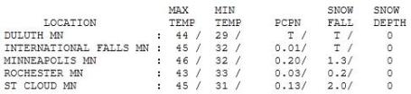
66.1" snow so far this winter in St. Cloud.
86.6" snow so far this winter in the Twin Cities (still the 4th snowiest winter on record - need another 2.4" to move into the #3 position).
2" snow fell at St. Cloud yesterday (2" at Kimball, 2.4" at Sauk Rapids).
1.3" snow fell Wednesday in the Twin Cities.
1.8" snow. Record snowfall for the Twin Cities - April 20 (set in 1982).
45 F. high on Wednesday at STC (average high is 57 F). Last year the high was 73 on April 20 in St. Cloud.
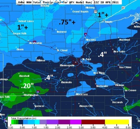
.67" rain predicted between tonight and Saturday evening (most of that falling Friday.
1.88" rain predicted for the area from this evening through midnight, April 27 (GFS).
Sunday: nicer, brighter, drier day of the weekend, chance of 60 F. by mid afternoon.
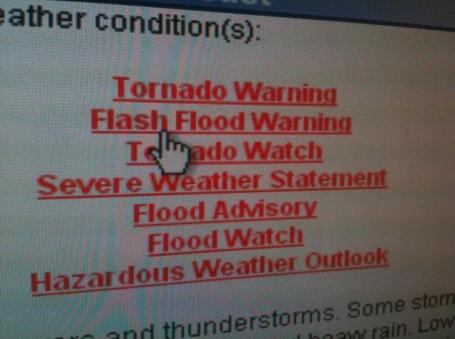
272: April tornadoes nationwide, a new nationwide record for the USA, and the month is a little more than half-over (Greg Forbes, The Weather Channel).
Dodging A (Wet & Muddy) Bullet. There is still some question/confusion about Minnesota's flood season. A number of people have stopped me and asked, "Paul, why wasn't the flooding as bad as predicted?" A good question. For some answers I went to the top of the food chain at the local NWS office in Chanhassen. Dan Luna is the MIC (meteorologist in charge) of the office, and he shared a few thoughts with me (in no particular order):
"It's accurate to say that Minnesota has been experiencing major flooding, but not record flooding, for a variety of reasons."
"We dodged a bullet this year. We had 3 distinct thaws in February, March and April. That slowed the rate of snow melt just enough to avoid catastrophic flooding. Prolonging the melt helped to avert a major disaster."
"Much of March and early April was cold and dry, which helped to reduce the volume of water flushed into Minnesota's streams and rivers."
"Minnesota was lucky in terms of a lack of major rainstorms. If we had picked up a couple inches of rain in March, when we still had heavy snow on the ground, flooding would have been considerably worse."
"There has been a tremendous amount of water in Minnesota's rivers. We've had a very long-duration flood event, some bridges over the Minnesota River have been closed now for nearly a month."
"The average length of (major) flooding in Minnesota may be close to 18 days, give or take. This year it was closer to 30 days."
"It could have been an order of magnitude worse had we experienced a sudden melt like we had last year..."
"Last year's temperatures (sudden thaw in March) coupled with this year's snow on the ground would have, in all probability, produced new records for flooding on Minnesota's rivers."
"Most of Minnesota's river flooding comes between September and May. The reason? Lack of vegetation. Vegetation: trees, lawns, shrubs and crops all absorb water, reducing the amount of runoff into area streams and rivers. When Minnesota greens up in May and June the potential for (major) river flooding drops off considerably because the vegetation-effect kicks in, pulling water out of the soil."
"We have to be on-guard until we get to Mother's Day. The combination of saturated soil and high water volumes means we need to be alert for 4-6 more weeks. Until we get to Memorial Day all bets are off! Hey, we're making up for last year!" (60s and 70s in March).
"Had the flooding rains that set up over Iowa come a couple hundred miles farther north, it would have been an entirely different story for Minnesota. The flooding rains stayed just to our south - that made all the difference this spring."
- Thanks Dan. Appreciate the additional information. We may have dodged a bullet, but we aren't quite out of the woods just yet.
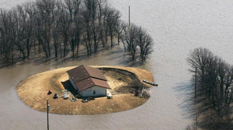
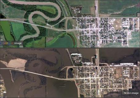
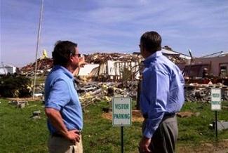
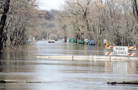
Aerial Photography Of Flooded Red River Valley. As Dan Luna from the NWS mentioned, flooding in parts of the Red River Valley is actually worse than it was in 1997. Here's
another perspective on the flooding from NOAA: "
Last week, the National Geodetic Survey dispatched NOAA's King Air aircraft, equipped with specialized remote sensing equipment, on a mission to collect aerial photography at 10,000 feet (3 km) across areas of the upper Midwest in midst of another spring with severe river flooding caused by melting snow atop already saturated ground. These "before and after" photos of the Red River Valley along the Minnesota-North Dakota border compare images taken in 2009/2010 by Google® Earth with photos taken from the NOAA aircraft. Photos were used to assist NOAA's National Weather Service to verify and validate flood models, and also assist local officials in planning their response and recovery efforts."
Happy Not To Be Showing A Snowfall Map. Yes, I'm pleased not to have to tee up another snow map (maybe for the next 6 months?) Showery rains arrive this evening, a potential for steadier, heavier rain on Friday as an area of low pressure tracks south/east of Minnesota. At least the atmosphere overhead will be warm enough for (all) rain.
Soggy Friday. Models all bring a few waves of (rain) showers into Minnesota tomororw, there may be enough instability and low-level moisture for a few PM T-storms tomorrow, especially over southwestern Minnesota. The ingredients aren't present for anything severe - and the risk of a severe outbreak next Tuesday seems to have shifted south/east of Minnesota.
It Could Be Worse - You Could Be Stuck In Green Bay. I can only imagine the ear-full meteorologists are getting in Green Bay. Tuesday's storm set new records. Photo above from the greenbaypressgazette.com, which has more details on the late season onslaught of snow
here. A few highlights:
*
9.9" of snow as of midnight Tuesday night.
*
Snowiest April day on record.
*
Most snow ever recorded from a late-season snowfall.
*
92.4" snow this winter (third snowiest on record, and the most winter snowfall since 1889-90)
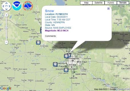
Slush-Fest. Wednesday morning looked like something out of early March - no sign of spring. Plymouth picked up 3" of slushy snow, over 2" reported up in friendly Fridley. To see interactive storm reports from the USA click
here, Google map and data courtesy of the San Diego office of the National Weather Service.
More Amounts. It's a tie, both Plymouth and Clear Lake will have to share the coveted (?) Golden Snow Shovel Award with 3" reports. More from the local NWS office
here.
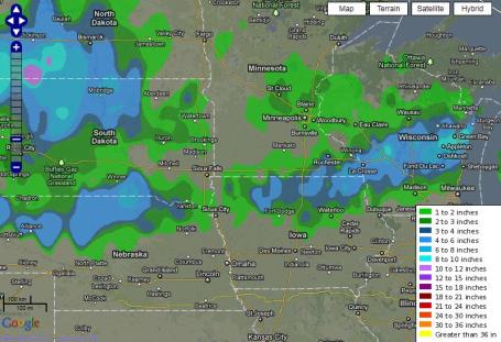
One Fickle Storm. Here is how much snow fell Tuesday - Wednesday, a big snowy bulls-eye over the Dakotas, another swathof significant snow across southeastern Minnesota into central Wisconsin. Click
here to see snowfall data on an experimental Google map, courtesy of the National Weather Service.
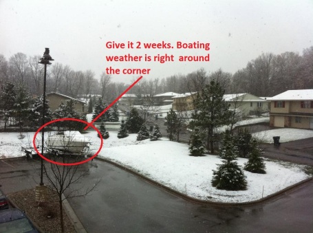
Only In Minnesota. The boat is waiting, we're counting down the days until (official) boating season here in Minnesota. Although I have seen my first boat on the lake this season. Some Minnesotans have an unofficial competition to see who can get their dock/boat in first. I tried that last year - 10 foot waves on 'Tonka wound up breaching the swim platform and overwhelming my bilge pump, sinking our 33 foot Regal (on Mother's Day Weekend). Not good. So I won't be trying that again anytime soon. With any luck this will be the last slushy photo I have to include in the blog until October...? Hey, a guy can dream.
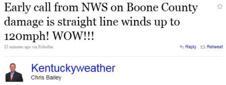
Have A Nice Day. Just another day predicting Kentucky's weather. Screen-grab courtesy of the National Weather Service.
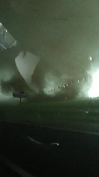
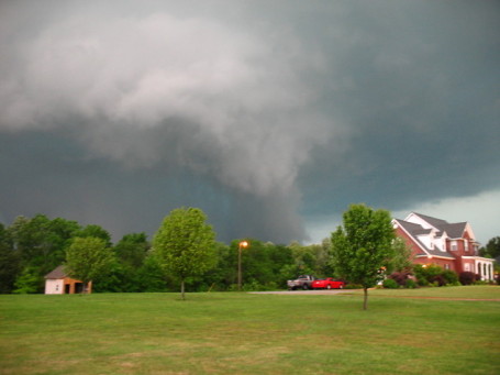
"Dad, Please Don't Drive Into The Tornado!" This is one of the more bizarre video clips I've seen, courtesy of WRAL-TV in Raleigh, North Carolina. A 12 year old keeps his iPhone video rolling as his (insane?) father drives straight into a multi-vortex wedge tornado near Dunn, North Carolina - while driving down I-95. No idea if they're OK. I'm assuming they survived the maelstrom, otherwise WRAL would not be posting
this footage. (Note: you have to turn your head sideways to see this properly, apparently the 12 year old shot this in "landscape" mode. Anyway, click on the link, you'll see what I'm talking about). Remarkable.
Raleigh Family Lost Homes In Hurricane Fran, Tornado. Redefining the meaning of "bad luck", WRAL-TV has a
story about a family who has been hit extra-hard by severe weather in recent years: "
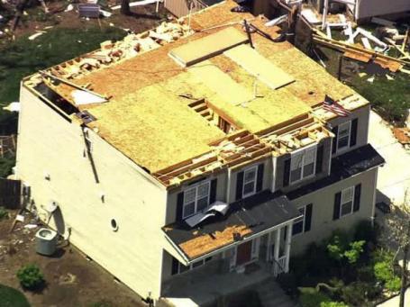
A Raleigh family whose house was destroyed by Hurricane Fran in 1996 lost a second home to natural disaster during Saturday's tornado. Kenneth Koscal, his wife and 5-year-old twin daughters were at home in a northeast Raleigh neighborhood off Forestville Road when the storm hit. "You could just sense something ominous was going to happen," he said. "I knew we were in trouble when I saw the pine trees were all starting to rotate." Koscal corralled his family into the downstairs bathroom and watched as his roof landed next door. All of the contents of the upstairs bedrooms were sucked out and scattered. "The air in front of you just turns black, and then every single pine tree and the roof all just went off in one fell swoop," he said."
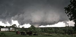
First-Hand Stories Of The North Carolina Twisters. The U.K.'s Daily Mail has a
harrowing account (and incredible photos) of last Saturday from people who survived EF-3 tornadoes, some were on the ground for more than 60 miles: "
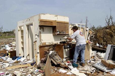
A huge clean-up operation has begun in North Carolina after the most violent storm on record. The 241 torndaoes last week in the Southeast left a trail of debris in the state, damaging or destroying more than 800 homes and leaving a recovery operation costing tens of millions of dollars. At least 22 people died in North Carolina, with the worst devastation coming over a four-hour period on Saturday and more than 250,000 people losing power."
Claims Counts, Losses Pile Up From Weekend Tornadoes. Propertycasualty360.com has
another angle on the storm, from the perspective of insurers: "
Residents and insurance adjusters from Oklahoma to North Carolina are sorting through piles of debris left by the massive strength of more than 200 tornadoes. State Farm says it has received more than 10,000 claims from the storms. Hundreds of claims adjusters are in the hardest-hit areas in North Carolina and Virginia. A significant number of homes will be declared uninhabitable or have sustained major structural damage, State Farm says. Steve Carroll, vice president and general manager for North Carolina Farm Bureau Insurance, says homes were lifted up off foundations and thrown dozens of yards."
Tornadoes Among Worst In History. Mississippi was hit particularly hard last Saturday; the Hattiesburg American has more
details: "
While officials continue to calculate the scope of destruction from last week's tornado invasion, experts believe the assault was one of the worst in Mississippi's, and the nation's, history. Around 300 families have lost their homes here, the Mississippi Emergency Management Agency reported. On Friday, Mississippi was one of the first states to face the fury of a three-day, severe-weather epidemic that killed at least 45 people, including one woman in Greene County: Debra Hill, 54, of Leakesville. As of Monday, weather.com estimated the nation's three-day tornado total at more than 150, accounting for duplicate reports, but the tally may grow."
"Up To 300 More Tornadoes Over The Next 2 Weeks?" Accu Weather meteorologist Heather Buchman has an
ominous prediction looking out through the last half of April. The weather is locked in a "high-amplitude" pattern, unusually strong jet stream winds sweeping across the USA. The combination of moisture from the Gulf of Mexico, surges of dry air pushing in from the Desert Southwest, and frontal boundaries separating warm, juicy air to the south from cool, Marchlike airmasses to the north, may set the stage for more outbreaks in the weeks ahead: "
In the wake of one of the worst tornado outbreaks in recorded history last week, more rounds of severe thunderstorms and tornadoes are predicted to bombard the same general region into early May. AccuWeather.com Senior Meteorologist Henry Margusity even stated in his blog Tuesday that over the next two weeks, he thinks there could be up to 300 more tornadoes within an area spanning from eastern Oklahoma to northern Mississippi, Tennessee, Ohio, Indiana and Illinois. "You may think that 300 tornadoes is a lot, but if you look at 2008, we had just that many in the two-week time period leading up to the second week of May," Margusity said in his blog. "Also, given the pattern, I don't think it's too unrealistic to think that many can happen."
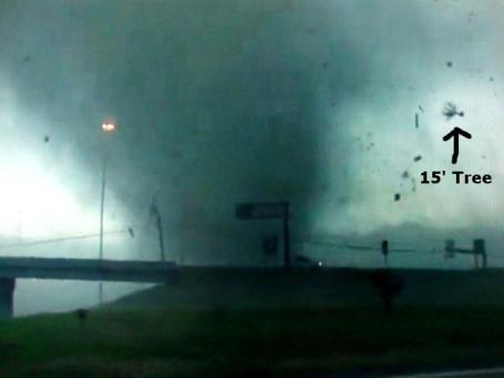
Could Tornadic Winds Really Be 800 Miles An Hour? I did a double-take when I saw this post, but see if you can follow NBC-TV Kansas City meteorologist Gary Lezak's
logic as he explains some frame-by-frame photographical evidence from a recent tornado strike in Jackson, Mississippi: "
There is a lot to think about as we go into this week. The weather pattern continues to cycle, according to Lezak’s Recurring Cycle (LRC), at around every 50 days. This is a very active pattern that, unfortunately, is set up to produce more tornadoes and more tornado outbreaks. For Kansas City and our viewing area, which we have fortunately missed these major severe weather episodes with the exception of the huge hailstorm event on April 3rd, we will likely end up just barely on the cold side of this week’s events. There are two storm systems that will affect us this week and I will go into more detail on these set-ups soon...These are pictures I took by snapping pictures from the video that Reed and his team caught near Jackson, MS. The above picture shows the tornado crossing I-20 near Jackson. Debris was just tossed into the air, but that would be an understatement. You can see a tree that is likely at least 15 feet, and possibly even bigger, that was uprooted and tossed at high speeds into the air and then rotated around the funnel before landing somewhere with tremendous force. This next picture is even more amazing. I circled a piece of debris, likely the size of a car, being tossed at an extremely high speed. There is a good chance that this large piece of a house or some structure, was catapulted at a speed stronger than the actual wind, if this is possible. This is where I want today’s debate to be concentrated on. I would say that this huge debris was tossed about two blocks in less than a half of a second. So, let’s say this is 0.2 miles, or around 0.4 miles/second. This would imply that the debris was moving at around 1440 miles per hour. If I am off and it was only 0.1 miles in that half second, this would still imply a speed of around 770 mph. When I was growing up as young kid interested in weather in Southern California I remember that in the 1960s and 1970s the tornadic wind speeds were thought to be as high as 800 mph. Why not? Wouldn’t this case verify this?"
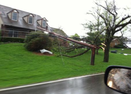
Damage Reports. From meteorologist Kristin Klinghutz, "
I just came across this and thought you could use it. It's from Union, Kentucky, on Frogtown Road."
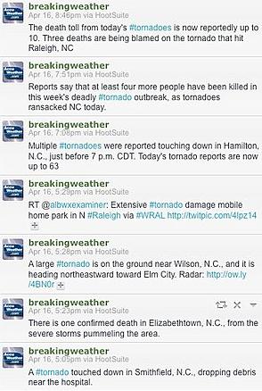
Social Media Spreads The Word About Severe Weather. One of the best sources of real-time severe storm information? Twitter. If you pick who you follow very carefully, you can get a blow-by-blow account of where the storms are, where they're going, and subsequent damage. It's amazing the amount of information that is available on-line and mobile, and it's only going to get more useful as more and more (citizen weather spotters) step up and not only consume media, but contribute reports, photos and videos. We are becoming a nation of amateur weather spotters and reporters. Accu Weather has a good
overview: "
With severe weather assaulting the United States, historic tornadoes, springtime snow and wildfires have wreaked havoc nationwide. Along with radio and television, social media is playing a more significant role in providing the public with up-to-the-minute weather information during the severe weather. For many people today, Twitter and Facebook have already become their primary sources for local weather information. Indeed, just do a simple Twitter search like "tornado," and you'll be greeted instantly by something like "In the past three days, there were 241 #tornado reports across 14 states." You can find important information during your morning coffee or while you are waiting for the bus."
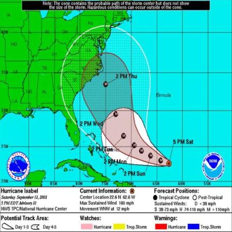
See How Much The "Cone" Has Shrunk. NHC, the National Hurricane Center, continues to refine the art of hurricane prediction. I've told you before the truth of hurricane prediction: models do a MUCH better job forecasting the track of a hurricane than its intensity upon reaching landfall. Refinements continue, according to Ken Kaye in his
Storm Center blog: "
The dreaded cone of uncertainty sure has shrunk in the past eight years. If you want to see how much, check out the above graphic, plucked off the National Hurricane Center’s Facebook page. It shows the original 2003 cone for Hurricane Isabel in white – and in maroon what that cone would look like today. The cone has been reduced as a result of the National Hurricane Center producing more accurate track forecasts. The center’s forecasters, in turn, credit improved computer models for shrinking forecast errors. The cone, which shows the probable track of a storm over a three- or five-day period, is constructed based on a series of circles, with each circle representing a forecast period. For the 24-hour forecast period, this year’s cone has a radius of about 68 miles, or 3.4 miles smaller than last year’s cone. For the 120-hour (five-day) period, the radius is about 275 miles, 53 miles smaller than last year’s cone."
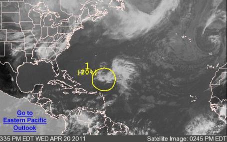
An Early Start To The Tropical Season? Slush, tornadoes and hurricanes, all on the same weather map? Can't say I've ever seen that before, but there's always a first time for everything. From
NHC, the National Hurricane Center:
A LOW PRESSURE AREA LOCATED ABOUT 460 MILES NORTHEAST OF SAN JUAN
PUERTO RICO HAS DEVELOPED SOME SHOWER AND THUNDERSTORM ACTIVITY
NEAR ITS CENTER.  IN ADDITION...SATELLITE DATA AND SHIP REPORTS
INDICATE GALE-FORCE WINDS ARE OCCURRING NORTH OF THE CENTER.  SLOW
DEVELOPMENT OF THIS SYSTEM IS POSSIBLE DURING THE COUPLE OF DAYS AS
IT MOVES WEST-NORTHWESTWARD AT ABOUT 10 MPH.  THERE IS A LOW
CHANCE...20 PERCENT...OF THIS SYSTEM DEVELOPING INTO A SUBTROPICAL
OR TROPICAL CYCLONE BEFORE CONDITIONS BECOME LESS FAVORABLE IN
ABOUT 48 HOURS.  ADDITIONAL INFORMATION ON THIS LOW CAN BE FOUND IN
HIGH SEAS FORECASTS ISSUED BY THE NHC/TROPICAL ANALYSIS AND
FORECAST BRANCH...UNDER AWIPS HEADER NFDHSFAT2 AND WMO HEADER
FZNT02 KNHC.  ANOTHER SPECIAL OUTLOOK WILL BE ISSUED ON THURSDAY...
OR SOONER IF NECESSARY.
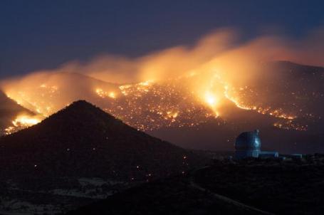
McDonald Observatory Gets Wild View of Texas Wildfires. Here's an amazing story from
space.com: "
A week after the Texas wildfires cut power to the McDonald Observatory, the worst appears to be over, according to Anita Cochran, the associate director of the observatory. Observations have resumed and the astronomy center is scheduled to open to the public today (April 20), after surviving a close call with menacing wildfires. At the observatory, located in West Texas, wildfire weather conditions have been among the worst in the state's history. Dry grass and dry air, along with hot temperatures and howling winds, are fueling the sprawling wildfires that have scorched a million acres across the state, according to the Texas Forest Service. [Photo of McDonald Observatory Amid Wildfires]"
* Photo caption/credit: "The Texas Forest Service undertook controlled burns on April 17 near the McDonald Observatory. Credit: Frank Cianciolo/McDonald Observatory.
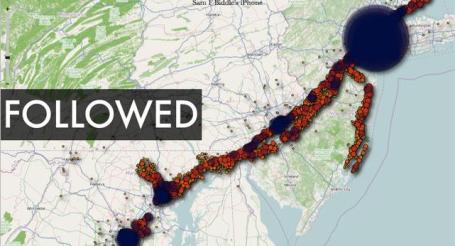
iSpy Conspiracy? Your iPhone Is Secretly Tracking Everywhere You've Been - All The Time. Good grief. I had a hunch Steve Jobs was stalking me. A new article in
Gizmodo by Sam Biddle confirms my worst fears. Does he know how I like my coffee (triple shot of expresso, a little vanilla to take away the bitter edge), that I like to take long walks on the beach, I obey all posted speed limits (when my wife is in the car), or that I secretly use my iPhone as a night light? Hope not. "
This is a map of everywhere I've been for nearly the last year. Everywhere. I didn't carry around a special tracking device. The FBI isn't sending goons in unmarked vans to track me. All I did was use an iPhone. And if you have an iPhone, you're being tracked right now, too, whether you like it or not. It turns out that all our iPhones are keeping a record of everywhere you've been since June. This data is stored on your phone (or iPad) and computer, easily available to anyone who gets their hands on it. Updated: 5:50 PM EST And now, we're wondering whether the same goes for our other smartphones. The opt-in wording of phone location service agreements is pretty nebulous (as agreements tend to be). When starting up a fresh Android, you're prompted to agree to the following: "Allow Google's location service to collect anonymous data. Collection will occur even when no applications are running." We asked Google what exactly this meant, and they refused to answer on the record whether this "anonymous" location data is logged persistently, a la iPhone. But, importantly, unlike the iPhone, it appears to be totally opt-in for users. Microsoft told us the only locational data stored on your Windows Phone 7 device is your last known location, for use with the Find My Phone feature. We've also reached out to Apple and BlackBerry-maker RIM for similar clarifications on data collection, but haven't gotten a response yet."
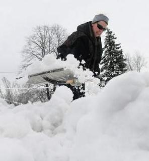
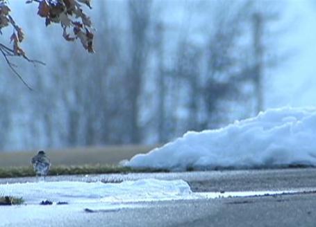
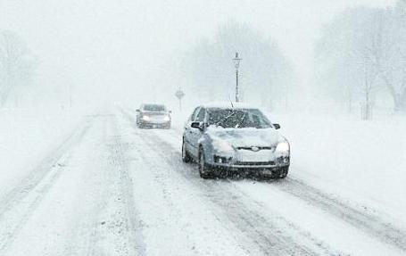
What April? No, it sure didn't look like April 20 out there Wednesday morning. Officially 1.3" of snow in the Twin Cities,
2" at St. Cloud. HIghs held in the 30s statewide, 13-15 degrees below average. Here's a groan-worthy statistic: last year the high on April 20 was a balmy 71 F.
(photo courtesy of Fox9)
Paul's SC Times Outlook for St. Cloud and all of central Minnesota:
TODAY: Partly sunny, hints of spring in the air again. Winds: SE 10-20. High: near 50
THURSDAY NIGHT: Cloudy with showers likely. Low: 37
FRIDAY: Foul. Heavier rain possible. High: 47
SATURDAY: Mostly cloudy, breezy and damp - a few sprinkles, a light shower possible. Low: 38. High: 50
SUNDAY: Nicer day of the weekend. Plenty of sun, risk of spring fever. Low: 39. High: near 60
MONDAY: Periods of rain, daffodil sightings. Low: 43. High: 58
TUESDAY: Few T-storms, slight severe risk? Low: 48. High: 60
WEDNESDAY: Shrinking puddles, some sun returns. Low: 44. High: 61
Feeling Lucky?
After muddling through a chilly March and Wednesday slush you may not feel lucky. But spring has been (relatively) kind to Minnesota, at least so far. "We dodged a bullet with flooding," Dan Luna, at the National Weather Service, told me yesterday. "We had 3 thaws in February, March and April. That, coupled with chilly weather, slowed the rate of snow melt." He explained that Minnesota rivers have experienced prolonged major flooding, but not record flooding. Why? No heavy rain events, and snow was able to melt gradually. "If we had experienced last spring's sudden thaw with the amount of snow we had this year, the results could have been catastrophic. I'm hearing reports that overland flooding on the Red River downstream of Grand Forks has been worse than '97," Luna added. Our chilly (relatively dry) spring had some definite benefits.
One of the most fickle, frustrating "storms" of the season is now long gone; the 2" of slush that delighted residents of St. Cloud on Wednesday a distant (?) memory.
Some morning sun gives way to (rain) showers by evening; heavier rain tomorrow. Clouds and sprinkles linger much of Saturday, a shot at 60+ Sunday with ample sun. More rain is possible late Monday into Tuesday of next week as yet another storm tracks off south of Minnesota (any severe risk probably staying well south/east of MSP). No more snow in sight - hopefully for 6 good, long months.
BP Marks Gulf Oil Spill Anniversary With Campaign Contributions. A
story from Huffington Post: "
WASHINGTON -- A year after BP's catastrophic Gulf oil spill, the petroleum giant is easing its way back into the political money race -- and the stain of shame candidates originally felt about accepting the company's contributions appears to have evaporated. The gas and oil giant's North America Political Action Committee filed its latest report with the Federal Election Commission Tuesday, which revealed $29,000 doled out to federal campaigns on its behalf. These figures mark the first contributions BP made that were not returned by federal office candidates since its drilling platform exploded on April 20, 2010, killing 11 people. "BP's political action committee had gone completely off the radar for the past year," noted Dave Levinthal of the Center for Responsive Politics. "It appears they're back in the political game." For many years before the spill, BP had been a "heavy hitter" by CRP's standards, Levinthal said. The company regularly gave more than $200,000 to candidates each year, spreading the wealth to both Democrats and Republicans."
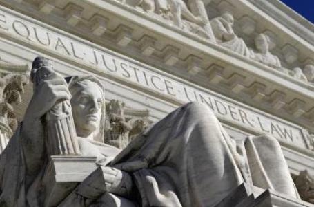
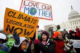
Justices Skeptical Of States' Global Warming Lawsuit. USA Today has an
update on the lawsuits which have reached all the way to the Supreme Court: "
WASHINGTON — The Supreme Court appeared ready to rule that federal judges cannot set limits on greenhouse gas emissions, after a majority of justices suggested Tuesday that such disputes over global warming are better left to Congress and federal regulators. Five power companies, including American Electric Power, are appealing a lower court decision that would permit a group of six states and the city of New York to sue under federal “public nuisance” law and claim the plants’ emissions intensify global warming. During a spirited session of oral arguments, the justices voiced doubt that judges have the authority or expertise to handle the complex emissions dilemma that is international in scope and that the government says is being addressed by the Environmental Protection Agency. A ruling would determine whether states can seek remedies in court for harm caused by carbon dioxide emissions and whether utilities would be subject to new litigation and possible caps on emissions."
*
Supreme Court Skeptical About Climate Change Suit. Nina Totenburg from NPR has
another look at the same issue before the judiciary: "
The politics of climate change hit the U.S. Supreme Court Tuesday, illustrating the powerful and unpredictable role the court can play in protecting the health and safety of the nation. Just four years ago, the justices repudiated the Bush administration and ruled 5-4 that the federal government has a duty to regulate carbon dioxide and other greenhouse gases under the Clean Air Act. But on Tuesday, the justices gave a chilly reception to state governments that are suing electric utilities over emissions that contribute to global warming. Tuesday's case was first brought in 2004 by a coalition of states and environmental groups. They sued the nation's five largest public utilities — companies that together produce 10 percent of U.S. carbon emissions annually. The states were seeking a court order to cap emissions. But for a variety of reasons, the lawsuit languished for five years. In the meantime, the Supreme Court ruled in a different case that the federal Environmental Protection Agency is required to regulate such emissions. What's more, President Obama took office, and under his lead, the EPA announced plans to regulate where the Bush-era EPA had not. The states' case, however, trudged on in the lower courts, and in 2009, a federal appeals court in New York ruled it could go forward to trial."
*
Judges Skeptical On Role Of Courts In Setting Emissions Standards. The New York Times has the
story here: "
WASHINGTON — A lawsuit by six states and New York City to force major power companies to reduce greenhouse gas emissions was met with seemingly unanimous skepticism from the justices on Tuesday during arguments at the Supreme Court. No one questioned the basic premise of the suit — that greenhouse gas emissions contribute to global warming. But there was essentially no support for the states’ position that courts are the proper forums in which to regulate the problem."
Transparent Photovoltaic Cells Turn Windows Into Solar Panels. Here's an encouraging
story from the New York Times Green Blog (Energy & the Environment): "
A new class of transparent photovoltaic cells has been developed that can turn an ordinary windowpane into a solar panel without impeding the passage of visible light, scientists said Tuesday. The cells could one day transform skyscrapers into giant solar collectors, said Richard Lunt, one of the researchers on the project. “We think there’s a lot of potential to be able to integrate these into tall buildings,” Dr. Lunt, a postdoctoral researcher at the M.I.T. Research Laboratory of Electronics, said in an interview. Previous attempts at transparent solar cells have either failed to achieve high efficiency or blocked too much light to be used in windows. But the new cells, based on organic molecules similar to dyes and pigments, are tailored to absorb only the near-infrared spectrum and have the potential to transform that light into electricity at relatively high efficiency."
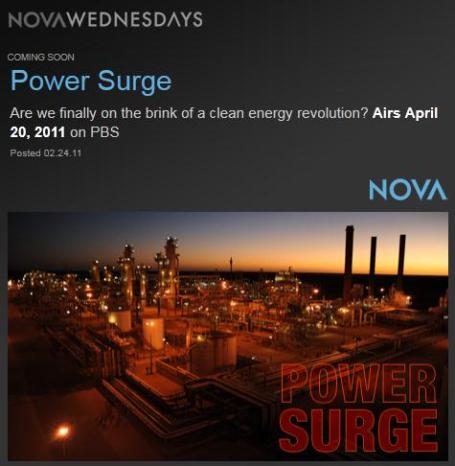
Energy Solutions. Last night I watched an excellent NOVA documentary on climate change, "
Power Surge", a thoughtful, informative, graphics-rich doc focused on solutions. It wasn't a hand-waving, gloom & doom tome, but a positive, encouraging, empowering hour highlighting the technologies that will get us to a new, greener energy future, less dependent on Middle Eastern crude oil, a future where we can have progress, growth and prosperity without dumping 9 BILLION tons of carbon into the atmosphere every year. "Power Surge" shared an amazing statistic: the average family releases 50 tons of carbon dioxide into the atmosphere every year, an almost unimaginable number. That has to come down over time if we're going to have a prayer of growing economies (without warming 3-8 degrees by the end of the 21st century). One viable option: solar power. Every year 100,000 terawatts of energy falls on the Earth's surface. We use about 17 terawatts of energy globally, so the potential is there, and (hopefully) new innovations will bring the price of solar down to the point where it can be adopted by everyone, on a commercial and residential scale. Is the USA going to be selling the marjority of photovoltaic cells and wind turbines, or will we be buying them from China? Click
here to read more about "Power Surge" on PBS. And I was surprised (and encouraged) to see that one of the underwriters of the show is David Koch, one of the Koch brothers - who have taken a lot of heat for funding climate denial. Are they having a change of heart? I have my doubts, but let's give credit where credit is due.
The Carbon War Room. I came across this innovative
web site, plenty of timely articles and resources. Entrepreneurs are watching the trends and here's the reality: there's plenty of green to be made by going green. Cynical? Not really. If we can find market-based solutions to weaning ourselves off of carbon-based fuels we're in trouble. It won't just happen by government decree. Governments can provide incentives and prime the pump, but in the end progress will come from hundreds of thousands of new and existing companies finding new ways to generate electricity (and power transportation), without pumping more greenhouse gases into the atmosphere: "
The Carbon War Room harnesses the power of entrepreneurs to implement market-driven solutions to climate change. The world needs entrepreneurial leadership to create a post-carbon economy. The War Room’s unique approach focuses on bringing together successful entrepreneurs, business leaders, policy experts, researchers, and thought leaders to focus on market-driven solutions. Our approach is to identify the barriers that are preventing market-based scale up of climate change solutions and thereby perpetuating the status quo. In addition to technology and policy gaps, these barriers include principal-agent problems, information gaps, and lack of common standards or metrics.
The War Room operates across 25 battles in 7 theaters and has three core functions:
- The Research & Intelligence team compiles a reliable, independent source of global research on the current carbon-industrial complex and leading market-driven innovations.
- The Communications team convenes successful entrepreneurs, experts, and leaders to ensure solutions are strategically sound, fast acting, and well presented.
- The Operations team plans the path to victory in each area using appropriate tools and partners to achieve the overwhelming force necessary. After determining partners, budgets, and leaders to execute the battle; funding is raised and milestones created; then the operation is closely monitored as each operation proceeds."
Money Not The Problem In U.S. Climate Debate. This article from Nature had me scratching my head but in the spirit of full disclosure I include it in today's story line-up. "
Environmental groups and their supporters spend more money on climate-change and clean-energy activities and campaigns than sceptical right-wing groups and their industry supporters, according to a report by a US social scientist, who questions some of the most common reasons given for US political inaction on global warming. But the report has stirred controversy, with critics claiming that its conclusions are not backed up by the data it presents, and that it ignores studies offering contradictory evidence. According to the report, conservative think-tanks, advocacy groups and industry associations raised some US$907 million during 2009, and spent a total of $787 million on their activities, with $259 million of that devoted specifically to climate and energy policy issues. Over the same period, national environmental groups had revenues of $1.7 billion and spent $1.4 billion on their programmes, which included $394 million devoted to climate and energy issues."
Do You Have "Global Warming Fatigue"? Just 25% of Britons Think Climate Changes Is The Most Important Environmental Issue. The U.K's Mail Online has the
story: "
Britons are suffering from 'global warming fatigue', according to a new poll which shows they care less about climate change than most other nationalities. The survey of 1,000 British adults found that just 25 per cent rate man-made climate change as the most pressing environmental problem. In contrast, half say energy security is the biggest green issue - while 48 per cent are more concerned about their rubbish collections....
Concern about man-made climate change fell after two cold winters and the failure of the UN global warming talks....Edward Langley, Ipsos MORI’s Head of Environment Research, said: 'The public are cautious about climate change. They feel there is a lack of consensus on whether it is man-made and the degree to which it will impact their lives. 'In contrast, our dependency on fossil fuels is a more immediate and tangible risk that they can get their heads around, and one where they see an obvious need to take action to maintain living standards.'
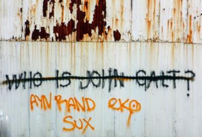
'Yo Global Warming Deniers: If The Galt Fits Then Wear It. The Moderate Voice has a
story about the current state of climate science denial: "
There were two literary sensations during my college years — J.R.R. Tolkein’s Lord of the Rings and Ayn Rand’s Atlas Shrugged. I took to Tolkein like a fish to water, but even my work-in-progress intellect recoiled at Rand’s belief system, which she called Objectivism and I called deeply flawed. Fast forward 40 years and Rand is back in fashion. Or perhaps never fell completely out of fashion for people, typically conservatives, often libertarians and consistently selfish, it would seem, who crave pat answers to simple questions. Objectivism is all that and more in a neatly wrapped package with a big bow. Objectivism holds that one can attain objective knowledge through processes of concept formation and inductive and deductive logic. Getting beyond that cosmic debris, Rand’s core belief was that the proper moral purpose of one’s life is the pursuit of their own happiness, which she called rational self-interest, and that laissez faire capitalism should be the coin of the realm. The big problem with all of this, which I was unable to grasp at the time but now finally understand in my semi-dotage, is that Rand and her acolytes tried and try to justify their behaviors through this belief system, which makes for some spectacularly odd square-peg-into-round-hole fits."
Who Are The "Contrarians"? Climate Change Task Force has a
good overview of the massive effort underway right now to sow confusion and delay any real progress on addressing climate change: "
The "contrarians" or "climate-change deniers" are a loud vocal minority. They include some practicing scientists, who however with rare exceptions are not professional practicing climatologists. HERE is evidence that contrarians in general have far less expertise in climate science than mainstream climatologists. The conservative MIT climatologist Kerry Emanuel labels contrarians as "mavericks" and "charlatans", see HERE. Many fields of science have fringe “mavericks”, generally without appropriate qualifications, who rail against established science. Usually these people are demonstrably wrong, violating some well established data or scientific principle, and are ignored. Their arguments do not constitute legitimate scientific debate. With climatology, such cranks are given wide publicity, generally by right-wing libertarian media, producing a false appearance of controversy. What is the Contrarian Agenda? The general agenda of contrarians is to derail meaningful discussion and actionon global warming by sowing confusion and influencing public opinion. Some contrarians do not have an overt political agenda but rather have an incomplete understanding of the relevant science. Regardless, the right-wing media push contrarian claims, and have unfortunately succeeded in the U.S. using this tactic. "


No comments:
Post a Comment