1.18" rain fell on the Twin Cities Tuesday. Street flooding was reported in downtown St. Paul.
.41" additional rain forecast for the MSP metro area by Thursday night (NAM model).
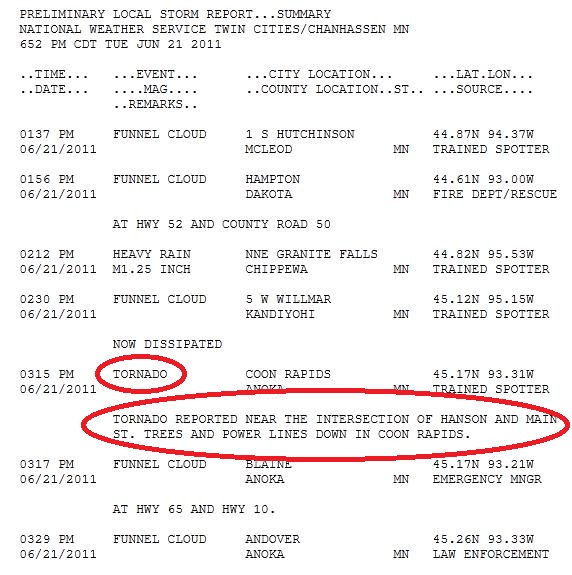
Funnels reported near Willmar, Hutchinson, Hampton (Dakota County), Blaine and Andover.
Tornado reported in Coon Rapids around 3:15 pm Tuesday afternoon (details below).
Another 1-2" rain possible by Thursday over central and western Minnesota as an unusually intense area of low pressure tracks across the Upper Midwest.
Flood Warning for the Minnesota River at Henderson, impacting Le Sueur, Scott and Sibley Counties.
Flood Watch in effect for Minnesota River at Montevideo AND the South Fork Crow River below Mayer, affecting Carver County.
Significant warming trend possible late June into the first week of July - string of 90s? We're due.

Tornadic "Super Cell" Thunderstorm. Click here to see a National Weather Service animation of the severe (rotating) storm that developed over Dakota County, and then tracked toward the north/northwest, drifting right over downtown St. Paul, before spinning up a brief tornado near Coon Rapids. The circled area shows a "velocity couplet", evidence of strong rotation within the thunderstorm - precursors to a tornado. There were numerous funnel reports before touchdown (a tornado warning was in effect at the time). The local NWS office has more on the possible tornado in the north metro here.
PUBLIC INFORMATION STATEMENT
NATIONAL WEATHER SERVICE TWIN CITIES/CHANHASSEN MN
734 PM CDT TUE JUN 21 2011

...STORM DAMAGE SURVEY TO BE CONDUCTED WEDNESDAY MORNING...

A NATIONAL WEATHER SERVICE STORM DAMAGE SURVEY TEAM WILL BE IN
THE BLAINE AND COON RAPIDS AREAS ON WEDNESDAY MORNING TO SURVEY
REPORTED DAMAGE CAUSED BY ONE OF THE STORMS ON TUESDAY AFTERNOON.
A PUBLIC INFORMATION STATEMENT CONTAINING DETAILS OF THE FINDINGS
WILL BE ISSUED UPON COMPLETION OF THE ASSESSMENT.
Flash Flood reported at St. Cloud. Details from the Chanhassen office of the National Weather Service:
0505 PM     FLASH FLOOD      ST CLOUD                45.55N 94.17W
06/21/2011                   STEARNS            MN   LAW ENFORCEMENT

            DELAYED REPORT. HEAVY RAIN ACROSS DOWNTOWN ST. CLOUD LED
            TO WATER HALF WAY UP VECHILES CAUSING 20 TO 30 TO BE
            STRANDED IN THE WATER. PEOPLE HELPED BY LAW ENFORCEMENT
            OUT OF THE VEHICLES.
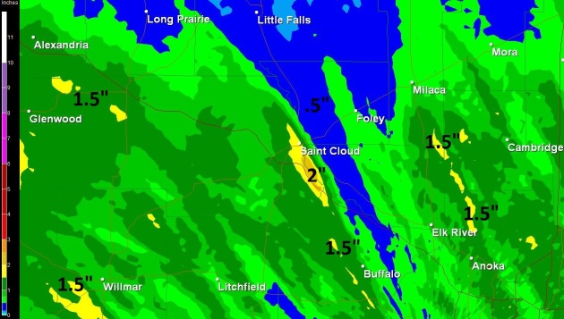
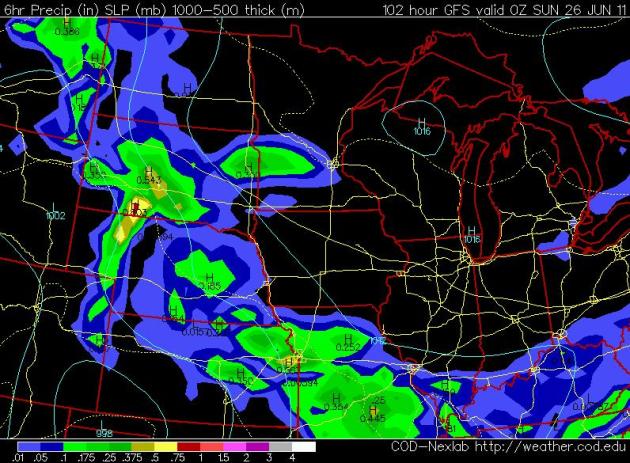
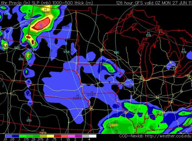
Anatomy Of A Flash Flood. The cell that drifted over St. Cloud dropped an estimated 2" of rain (most of that in less than 1 hour). With a saturated ground that water couldn't soak into the soil - it almost immediately ran off into streets - triggering an instant flood, a "flash flood".* The storm isn't over. The unusually intense area of low pressure will continue to spark rain, heavy at times, today into part of Thursday. Many communities in western and central Minnesota will receive another 1-2" rain before skies finally clear by Friday. This will compound the flood risk over much of Minnesota. This kind of (river) flooding is typical in March and April, but in June? Highly unusual.
FLOOD WATCH
NATIONAL WEATHER SERVICE TWIN CITIES/CHANHASSEN MN
955 PM CDT TUE JUN 21 2011

...THE FLOOD WATCH HAS BEEN UPGRADED TO A WARNING FOR THE
FOLLOWING RIVER IN MINNESOTA...

  MINNESOTA RIVER AT HENDERSON AFFECTING LE SUEUR...SCOTT AND SIBLEY
  COUNTIES

...THE FLOOD WATCH CONTINUES FOR THE FOLLOWING RIVERS IN MINNESOTA...

  MINNESOTA RIVER AT MONTEVIDEO AFFECTING CHIPPEWA...LAC QUI PARLE
  AND YELLOW MEDICINE COUNTIES

  SOUTH FORK CROW RIVER BELOW MAYER AFFECTING CARVER COUNTY

WIDESPREAD RAINFALL AMOUNTS BETWEEN 1 AND 3 INCHES WITH ISOLATED HIGHER
AMOUNTS OVER THE LAST COUPLE OF DAYS HAS RESULTED IN RISES ON AREA RIVERS.
SHOWERS ARE EXPECTED TO CONTINUE ACROSS THE AREA THROUGH THURSDAY...WITH
ANOTHER 1 TO 2 INCHES OF RAIN POSSIBLE ACROSS MAINLY WESTERN AND CENTRAL
MINNESOTA.  THIS EXTRA RAINFALL WILL CONTINUE TO AGGRAVATE THE FLOODING
SITUATION ACROSS MINNESOTA IN THE COMING WEEK.
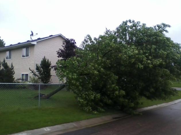
Wind Damage. Winds in St. Micheal were strong enough to bring down trees - this photo sent in my Sheena Nelson.
Funnel/Tornado Reports. Here is a NWS run-down of the severe storms that swept from south to north across the metro area during the mid afternon hours. The most significant damage appears to have been in the Coon Rapids area, reports of numerous trees and powerlines down..
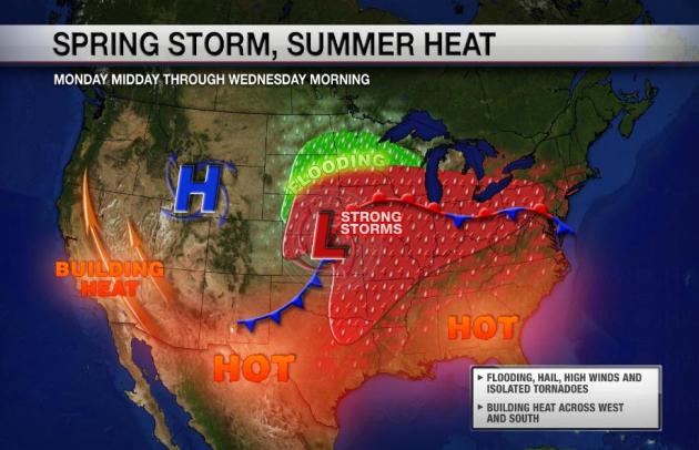
The Maps Sure Don't Look Like Summer. Yes, the musty calendar on the wall is whispering summer, but the atmosphere is SHOUTING spring. As far as the weather pattern is concerned it's late April, maybe early May. The jet stream, the high-speed river of air that whisks storms around the Northern Hemisphere, is unusually strong, and still blowing 500-800 miles farther south than usual. An unusually intense (spring-like) storm is pushing across the Upper Midwest, moving very slowly (5-10 mph), and that will prolong heavy showers into at least Thursday. North and west of the storm track: heavy, sustained rains (1-3" amounts), making a bad situation much worse in the Missouri River basin. South and east of the storm track: enough instability, low-level moisture and wind shear for tornadic storms - the biggest outbreak expected since May 25. Thanks to Nick Shipes from Ham Weather (division of WeatherNation) for the fancy graphic.
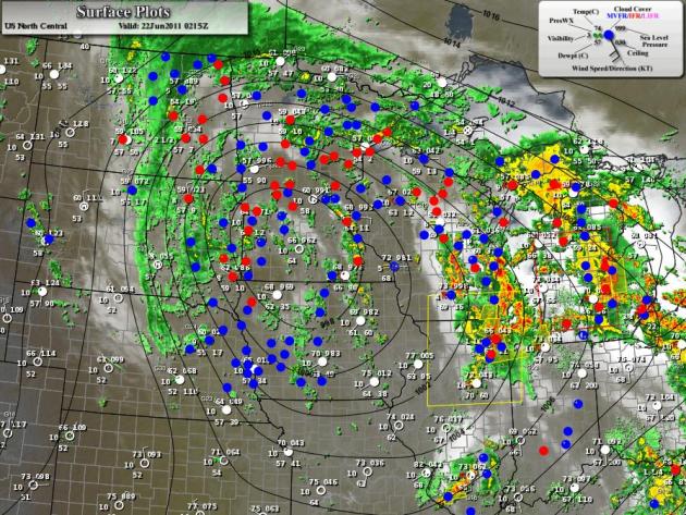
Atmospheric Time Warp. The surface map at 9 pm Tuesday showed an unusually intense area of low pressure centered over southwestern Minnesota (pressure of 29.41" at Olivia) - spiral bands of moisture wrapping around the powerful, almost April-like storm. Strong/severe storms were flaring up on the warm, southeastern side of the storm track, enough warmth, low-level moisture and instability to spark hail and tornadic storms from Wisconsin and Illinois into Michigan. On the cool, stable (northern/western) side of the storm, steady/heavy rain - some 2-3" amounts across the Dakotas, rain falling on saturated soil, running off and compounding the flooding scenario along the Missouri River.
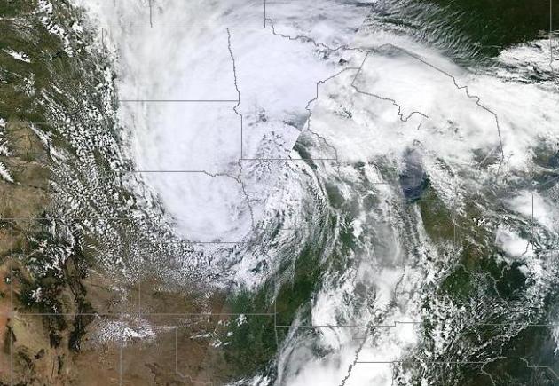
Typical For April - Not The Summer Solstice. The weather is still out of whack (and we can't blame La Nina any more - the Pacific Ocean has warmed to an "ENSO-neutral" state according to NOAA). The midday visible (MODIS) satellite image from NASA showed an amazingly deep area of low pressure, a "stacked low" centered over northwestern Iowa, counterclockwise winds pumping moisture from the Gulf of Mexico northward, fueling severe thunderstorms from the Twin Cities and St. Cloud southeast to Milwaukee and the Chicago area.
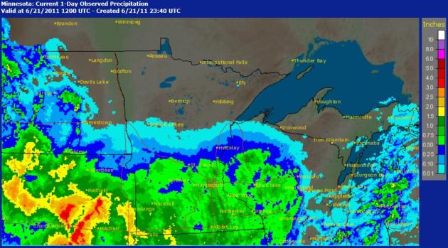
A Week's Worth of Rain In 24 Hours. Doppler radar rainfall estimates show .50 to 1.25" over the southern half of Minnesota, with some 2-3" amounts falling on South Dakota. Click here to see the data from NOAA.
BULLETIN - IMMEDIATE BROADCAST REQUESTED FLOOD WARNING NATIONAL WEATHER SERVICE TWIN CITIES/CHANHASSEN MN
1115 AM CDT TUE JUN 21 2011
...THE NATIONAL WEATHER SERVICE IN CHANHASSEN HAS ISSUED A FLOOD WARNING FOR THE FOLLOWING RIVERS IN MINNESOTA...
MINNESOTA RIVER AT HENDERSON AFFECTING LE SUEUR...SCOTT AND SIBLEY COUNTIES
MINNESOTA RIVER AT SAVAGE AFFECTING DAKOTA...HENNEPIN AND SCOTT COUNTIES
THIS RIVER FORECAST IS BASED ON OBSERVED PRECIPITATION OF 0.75 TO 1.5 INCHES OVER THE PAST 12 HOURS AND FORECAST PRECIPITATION OF 1 TO 3 INCHES OVER THE NEXT 48 HOURS. HEAVY RAINS COULD CAUSE RIVER LEVELS TO RISE EVEN HIGHER THAN PREDICTED.
SYNOPSIS...A STRONG SURFACE LOW PRESSURE SYSTEM COUPLED WITH AN UPPER LEVEL LOW PRESSURE AREA HAS MOVED INTO THE UPPER MIDWEST AND ALREADY PRODUCED RAINFALL AMOUNTS FROM 0.75 TO 1.5 INCHES ACROSS A LARGE AREA IN SOUTHERN MINNESOTA. THIS SYSTEM IS EXPECTED TO PRODUCE ADDITIONAL RAINFALL OF UP TO 3 INCHES IN LOCAL AREAS THROUGH THURSDAY MORNING. THE ALREADY OBSERVED RAINFALL AND THE FORECAST RAINFALL WILL BEGIN RAISING STREAM AND RIVER LEVELS ACROSS THE REGION. ADDITIONAL RISES ARE POSSIBLE IN THE RIVER LEVELS AS THE CURRENT RIVER FORECASTS ONLY INCLUDE 24 HOURS OF FORECAST PRECIPITATION.
THE NATIONAL WEATHER SERVICE WILL MONITOR THIS DEVELOPING SITUATION AND ISSUE FOLLOWUP STATEMENTS AS CONDITIONS OR FORECASTS CHANGE.
PRECAUTIONARY/PREPAREDNESS ACTIONS...DO NOT DRIVE CARS THROUGH FLOODED AREAS. TURN AROUND...DON'T DROWN.
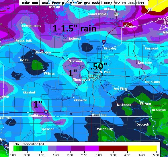
Additional Rain. The NAM model prints out close to .5" rain today and Thursday, closer to 1" near St. Cloud, with some 1 to 1.5" amounts possible over northern Minnesota. This will complicate the flood forecast, especially on the Minnesota River.
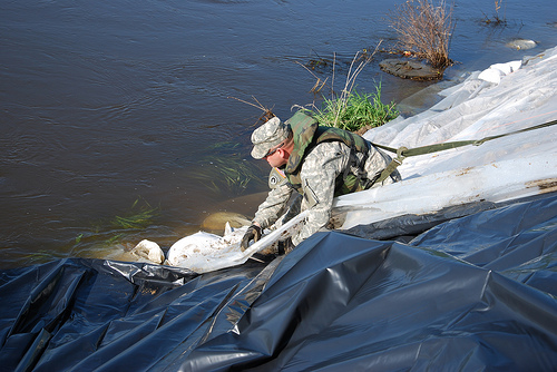
Minot, North Dakota Flooding. Water is surging down the Souris River Valley - the river is forecast to inundate Minot to a level 7 to 8 feet higher than the catastrophic and benchmark flood of 1881. Mandatory evacuations were ordered Monday for all evacuation zones within Minot; residents must evacuate those areas no later than 10 pm Wednesday. This is the second time this year that local resident have been forced to flee to higher ground. Most of the city is forecast to be inundated by the weekend.
**Sudden river level change cause by massive rainfall in Canada.
**The Souris River Basin near the Rafferty Dam in Saskatchewan received four to seven inches in that area Sunday night and 24,000 cfs is coming our way from Canada.
**There is not enough room in the Lake Darling Reservoir upstream from Minot to hold back that much water.
**Minot leaders come to the realization that the Souris River will overtop their levees and there is nothing they could do about it. The numbers were changing so fast Monday that the City was in the process of raising dikes to 12,000 cfs when they realized dikes couldn’t be raised in time.
**The amount of water flowing with a vengeance down the Souris River Valley is forecast to inundate Minot to a level seven to eight feet higher than the catastrophic and benchmark flood of 1969.
**Mandatory evacuations were ordered Monday for all evacuation zones within Minot... 10,000 people must vacate those areas no later than 10 p.m. Wednesday. Residents moving out of their homes for the second time this year.
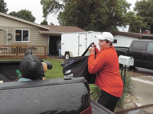
The Great Escape. An estimated 10,000 residents of Minot, North Dakota,living along the Souris River, were ordered to evacuate. The Army Corp of Engineers has pretty much given up on trying to protect the entire city - levees remain around hospitals and schools, but people are getting out as fast as they can. The Minot Daily News has the latest: "Disastrous. Unstoppable. Historic. Unprecedented. All words used to describe what city, county and state officials warn is an imminent assault on all residents of the Souris River Valley. The highest flows ever recorded on the Souris are approaching a city whose defenses are destined to be over run. Can the city hold? Dikes currently in place, recently improved greatly to combat high flows, are now expected to disappear under the traveling torrent. The amount of water flowing with a vengeance down the Souris River Valley is forecast to inundate Minot to a level seven to eight feet higher than the catastrophic and benchmark flood of 1969. Saddened with that horrific knowledge, officials announced during a late afternoon press conference Monday that very little can be done to stop the powerful onslaught. Massive secondary dikes that were built by the U.S. Army Corps of Engineers to save much of the town from the previous high on the Souris this year fall far short of defending against the impending and rapid rise of the Souris. Mandatory evacuations were ordered Monday for all evacuation zones within Minot. Mayor Curt Zimbelman said all affected residents and businesses must vacate those areas no later than 10 p.m. Wednesday. Within minutes of the announcement residents once again began the laborious and hastened work of moving out of their homes for the second time this year."
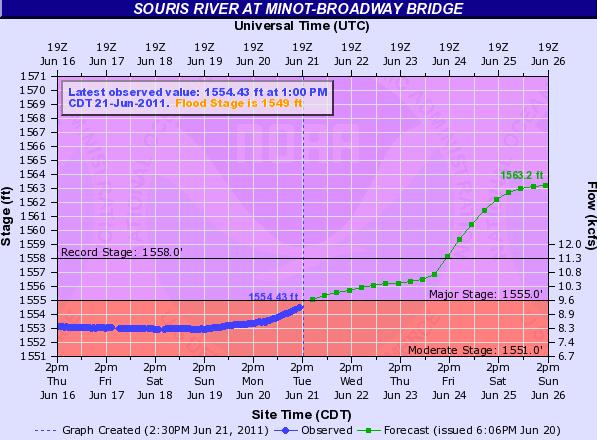
Record-Breaking Flood. The Souris River in Minot is forecast to crest at least 5 feet above the record flood state (set in 1969) by Sunday. More details from NOAA hydrologists here.
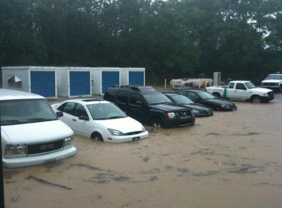
Flash Flood. This is a photo taken from the Insight Communications parking lot in northern Kentucky, near Covington. Insight is a client of WeatherNation. Photo courtesy of Insight Communications and yfrogcom.
Too much moisture north, not nearly enough over the southern USA:
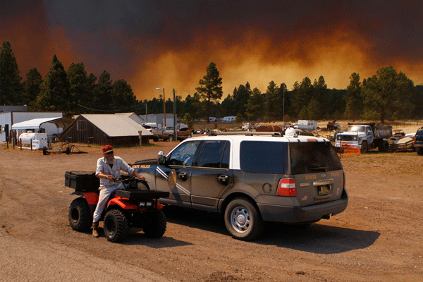
"Wallow Fire" Update. The Wallow blaze is the largest in Arizona history. In recent days winds have subsided, allowing a small army of firefighters and smoke-jumpers to make some progress:
Current Size: 527,774 acres.
Containment: 56% (no estimate on expected date of full containment).
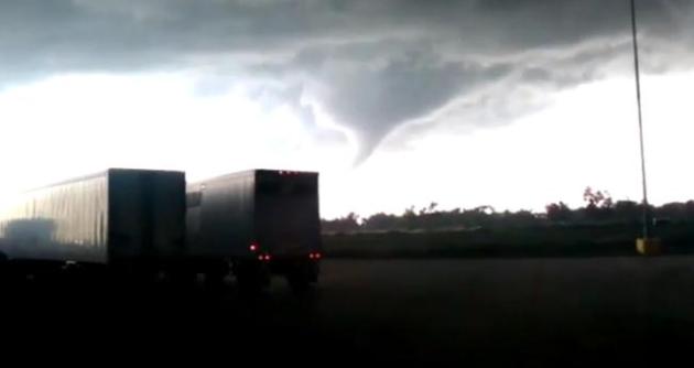
Elm Creek, Nebraska Tornado. 43 tornadoes touched down on the central and northern Plains Monday, including this tornado. The video clip was captured on an Android smartphone: "a roof was partially removed from one house, a second house received major roof damage, while several other houses in town sustained roof damage as well. Metal buildings on the outskirts of town were demolished."
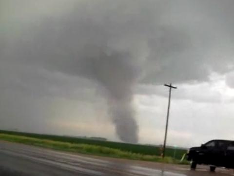
Elm Creek Tornado, Part II. Thanks to Matt Carlson for capturing some amazing footage (Android smartphone) of the tornado that ripped across Elm Creek, Nebraska late Monday.
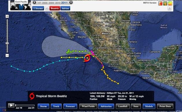
"Beatriz" Downgraded To A Tropical Storm. For a time on Tuesday Beatriz was a Category 1 hurricane with sustained winds of 90 mph. The storm has weakened to Tropical Storm status, peak winds of 60 mph, expected to weaken rapidly as it passes over colder Pacific Ocean water. Graphic courtesy of Ham Weather, a division of WeatherNation.

Drought Presents A Genuine Danger For Birds. Houston is running a nearly 20" rainfall deficit since October of 2010. The town of Midland, Texas has only picked up .16" of rain since January 1. Much of Texas is in the midst of an "exceptional drought"; the Houston Chronicle documents the impact of the drought on the local bird population: "The devastating effects of the Texas drought on birds was evident during a hike deep in Sam Houston National Forest. I was looking for nesting migratory songbirds such as Northern parulas, white-eyed vireos, Swainson's warblers and the handsome, golden-yellow plumed prothonotary warbler. In normal years, nesting songbirds sing in profusion near the wet sloughs, oxbows, creeks and ponds dotting the forest on the northern edge of Lake Conroe. Not this year. Most creeks and oxbows are bone dry. Ponds and lakes are retreating from their banks and offer only shallow water. I should have found a profusion of prothonotary warblers. But I found only few nesting pairs. And I couldn't find a single Swainson's warbler. White-eyed vireos and Northern parulas nesting along the few tributaries holding water were doing OK but not showing up in spectacular numbers, and few if any had fledged young. More worrying was the dearth of insects. Dragonflies and damselflies, a major food source, were scarce. Even wasps were not to be seen. And swallowtail butterflies, whose caterpillars and winged forms nourish birds, weren't showing up in plentiful numbers. The lack of water and insects means many songbird chicks may die from lack of nutrition. Many parent songbirds may be dangerously weakened from lack of food before their migratory journey south in a few months. "Certainly for forest songbirds, the greatest impact of the drought is the reduced insect abundance at a time when birds really expect the normal superabundant supply for feeding their offspring," said Cecilia Riley, executive director of the Gulf Coast Bird Observatory."

Drought Forces More Human-Alligator Interaction. No, don't sweat the showers and sprinkles. There's a 10% probability of an alligator-encounter, at least if you live in Florida. WALB-TV has the harrowing story: "LOXAHATCHEE, FL (WPTV/NBC) - Florida's drought has forced alligators to interact with humans when they go in search of freshwater to inhabit. Darrin Spardello was enjoying the Loxahatchee National Wildlife Refuge when the Lake Worth resident opted for some higher ground after a nice sized gator climbed onto land not far from where he was standing. "He was about 5 to 6 feet away," Spardello said, "but usually they stay in the water." The water levels are so low, the alligators are moving in that much closer. "I've never seen this many, ever," Spardello said. "I've never seen this many gators out here." Executive Director of the Busch Wildlife Sanctuary David Hitzig said one should expect to find alligators where the water is. "They do need water to drink and a place to find food and water also gives them a place to hide," Hitzig said. Alligators are a natural part of South Florida's environment, making their homes in freshwater habitats all around our area, but Hitzig said people need to keep a safe distance. "The greater the distance, the better," Hitzig said. Hitzig added that people should never feed an alligator."
* No kidding...
Excessive Heat Warning For Metro Phoenix Area
Records for Phoenix:
June 22 (Wednesday) Record: 116
June 23 (Thursday) Record: 114
Forecast high: 113 & 112
All-time June records
Rank Value Ending Date
1 122 6/26/1990
2 120 6/25/1990
3 118 6/28/1990, 6/27/1990, 6/24/1929
6 117 6/29/1994, 6/28/1979
8 116 6/28/1994, 6/26/1994, 6/25/1994
Meteorology:
A HIGH PRESSURE SYSTEM WILL BEGIN TO AMPLIFY OVER THE REGION THIS
WEEK. EXCESSIVE HEAT WARNINGS HAVE BEEN POSTED FOR MUCH OF SOUTHEAST
CALIFORNIA...AND SOUTHWEST AND SOUTH CENTRAL ARIZONA FOR WEDNESDAY
AND THURSDAY. AFTERNOON TEMPERATURES WEDNESDAY AND THURSDAY WILL
RANGE FROM 113 AND 116 DEGREES.
...EXCESSIVE HEAT WARNING IN EFFECT FROM 10 AM WEDNESDAY TO 8 PM
MST THURSDAY...
THE NATIONAL WEATHER SERVICE IN PHOENIX HAS ISSUED AN EXCESSIVE
HEAT WARNING...WHICH IS IN EFFECT FROM 10 AM WEDNESDAY TO 8 PM
MST THURSDAY. THE EXCESSIVE HEAT WATCH IS NO LONGER IN EFFECT.
* AFFECTED AREA: SOUTH-CENTRAL ARIZONA INCLUDING THE PHOENIX
METROPOLITAN AREA.
* thanks to James West from Earth Networks for passing along the Phoenix records. My friends living in Arizona often tell me "Paul, it's a DRY HEAT!" True. My oven is a dry heat, and I still don't stick my head inside...

Chilean Ash Cloud Grounds Australian Flights Again. CNN has the story: "An ash cloud drifting around the world for a second time after spewing from a Chilean volcano more than two weeks ago is once again grounding commercial jets and stranding thousands of passengers in Australia. After grounding flights across the country Tuesday, Qantas announced that all scheduled international flights in and out of Sydney and Melbourne were cancelled for Wednesday as well.The cancellations include scheduled trips across the Tasman Sea to New Zealand. The June 4 eruption of Puyehue-Cordon Caulle volcano in the Chilean Andes Mountains forced the shutdown of flights in and out of at least 10 Australian cities Tuesday. The same ash cloud spawned by the fiery South American volcano also forced major flight cancellations Down Under two Sundays ago. The airlines' decision to ground the flights was based on information provided by the Australian Volcanic Ash Advisory Center. "The volcano has remained active and as of the 9th of June, the ash plume from the original eruption has traveled across the southern Atlantic Oceans and under Africa to stretch into the Indian Ocean," the advisory center stated. "It is not unprecedented for volcanic ash to remain suspended for long time periods."
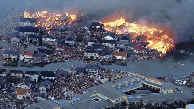
From Devastation In Japan, Vital Data. Here's an interesting story from the New York Times: "The earthquake in Japan earlier this year was massive and devastating, but it also provided researchers with an unprecedented amount of data, thanks to Japanese investment in earthquake-monitoring technology. Writing in the journal Nature, Japanese scientists from the Geospatial Information Authority of Japan used the data to determine that the earthquake’s slip was unusually large in comparison with its rupture area, estimated to be 150,000 by 400,000 yards. The slip, or the ground movement along the fault that caused the earthquake, exceeded 30 yards. Yet the rupture area was significantly smaller than the rupture area of the less severe Sumatra earthquake of 2004. “Generally, there is a strong relationship between slip and area, but this is an outlier,” said ’Jean-Philippe Avouac, a geologist at the California Institute of Technology who was not involved in the study. “In a way, you could have guessed the rupture area. But because of the amount of slip, you would have a hard time to guess the magnitude.” In addition, the slip along the fault appears to have occurred at the relatively shallow depth of about six miles, resulting in a major tsunami."
Saturday Preview: Highs near 80, plenty of sun over the northern half of Minnesota (should get better the farther north you are). The GFS is hinting at a few PM T-storms, best chance from Montevideo and Willmar into St. Cloud and the Twin Cities. That said, much of the day should be dry.
Sunday Preview: Southerly winds increase on Sunday (10-20 mph), more clouds than sun south of the metro, but ample sun over central and northern Minnesota. A few T-showers may pop south of the Minnesota River. God-willing, no all-weekend-washouts.
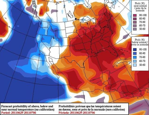
Serious Warming Trend. The European ECMWF model is predicting a significant warming trend from late June through the first week of July. Yes, odds favor a hot 4th of July. That would be just about right - with the exception of that freak 103 F. reading on June 7 we really haven't seen any sustained heat. It's time.
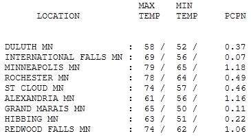
Soggy Start To Summer. An estimated 2"+ rain fell in less than 1 hour around 5 pm yesterday in St. Cloud, leading to considerable flash flooding. 1.18" of rain fell on the Twin Cities yesterday, the most of any regular reporting station in Minnesota. Over 1" fell at Alexandria and Redwood Falls. Highs ranged from a chilly 58 at Duluth to 74 at St. Cloud, 78 in Rochester and 79 in the Twin Cities.

Paul's SC Times Outlook for St. Cloud and all of central Minnesota:
TODAY: Showery rains. Unusually cool for June. Winds: N 10-15. High: 66
WEDNESDAY NIGHT: More showers, sweatshirt weather. Low: 53
THURSDAY: Slow-motion storm aloft. Showers linger - still chilly. High: 62
FRIDAY: More clouds than sun, getting better (and milder). Low: 53. High: 74
SATURDAY: Partly sunny, nicer day of the weekend? Winds: SE 5-10. Low: 56. High: near 80
SUNDAY: Sunny start, PM T-storms possible. Winds: SE 10-15. Low: 60. High: 80
MONDAY: Few showers, heavy T-storms. Low: 63. High: 81
TUESDAY: Lingering showers, steamy again. Low: 66. High: 86

Lightning Photo courtesy of Olivier Vandeginste, copyright 2005.
Daunting Statistics
Welcome to the 6th deadliest tornado year on record across the USA. In spite of Doppler radar and very timely warnings 533 Americans lost their lives this year, the most since 1936.
Damage from severe storms, floods and wildfires may top $35 billion, according to insurance estimates. By comparison Hurricane Katrina cost the U.S. about $81 billion.
This is Lightning Awareness Week; 5 people have already been struck & killed this year. By definition any T-storm is potentially dangerous, especially for people on lakes, beaches (or fields). Any open space is a dangerous place to ride out an electrical storm. Men are far more likely to be struck. "Nearly eighty-five percent of lightning victims are male, and this has been true since we began keeping records in 1959," according to a NOAA spokesman. Why? More men work outside, and (speaking from experience) men are often more stubborn, reluctant to get off the golf course or farm machinery. Just a theory.
Showers linger into Thursday, the atmosphere too cool/stable for severe storms. Skies clear Friday; we may actually salvage a decent weekend, T-storms popping up by Sunday afternoon. Come to think of it, we're due for a break.

How Politicians Intimidate Global Warming Scientists. Steve Levingston in the Washington Post has a timely book review that exposes the pressure climate scientists are under: "Imagine that an international group of scientists issued a stark warning that the world was very likely going to experience an increasing number of earthquakes, tsunamis and volcanic eruptions. And that this warning was endorsed by the U.S. National Academy of Sciences and every other major scientific organization in the world. How would the U.S. Congress respond? Would it hold hearings and invite scientists untrained in these geological hazards to testify? Would it promote the ideas of those who argue that earthquakes don’t exist? Would it invite novelists to discuss the merits of the topic? Would some Congress members sit on their hands and do nothing, urged on by the construction industry, which might benefit from all the new work that the impending disasters would bring their way? Would they go after the scientists who brought forward the warnings about the looming threats, and seek to intimidate them and destroy their reputations and careers? This scenario might seem far-fetched, yet this is exactly the situation that has unfolded over the issue of global warming. Scientific assessments have repeatedly and consistently shown that global warming is real, and largely the result of the burning of fossil fuels. These studies also show that there are real and present dangers if fossil fuel consumption is not reduced. The dangers include an increasingly unstable pattern of global climate, more severe weather and the inundation of low-lying coastal areas (where most big cities are located) due to a rise in sea level. These changes will impact agriculture and affect the world’s poorest people disproportionately. U.S. military experts consider the changes to be a “threat multiplier,” leading to societal instability in many regions, with potentially significant consequences for national security."

Heat Will Kill More Than Cold In Europe Eventually. Kind of a lame headline, but there's science to back up that claim, as reported by ABC News and AP: "A new study says one of the few benefits of global warming — fewer deaths from the combination of extreme heat and cold — may eventually melt away in Europe. For years, scientists figured that with global warming there are fewer overall temperature-related deaths when those from heat waves and cold snaps are combined. The increase in heat wave deaths during hotter spells is more than offset by reduced cold deaths in milder winters. But a new study in Europe finds that around 2040, the increase in heat deaths will likely outweigh the reduction in cold deaths. The study suggests that by 2070, global warming may cause 15,000 more temperature-related deaths a year in Europe, which has less air conditioning than the United States. The study released Tuesday by Nature Communications looks only at deaths from heat and cold, not increases from flooding, droughts and storms. It used computer models to analyze the climate under global warming and compares those to death rates in 200 separate regions of Europe."

Global Warming Spurs "Spring Housecleaning" Of Honeybees. Uh oh. Don't mess with the honeybees. CO2 Science has the story: "Writing in Ecological Entomology, Sparks et al. (2010) note that "honeybees are an essential component of modern agriculture," and that "large acreages of pollinator-dependent crops, such as apples, almonds, blueberries and cranberries, require managed pollinators, mainly the honeybee, to ensure maximized production." However, they report that several modern studies suggest that synchronization of pollinator activity and flowering may be changed by rapid global warming, leading to deficient pollination when it is most needed and resulting in reduced crop productivity. Noting that little work has focused on this imagined problem, the six Polish scientists decided to investigate the dates of honeybees' first cleansing flights that occur in the early spring of each year after overwintering, which flights, in their words, "are undertaken by worker bees excreting faeces accumulated in their recta while restricted in the hive for the winter during cold weather." Working in the vicinity of Poznan, Poland, they analyzed annual records of the first observed cleansing flights of honeybees from between 80-130 hives made by four to six competent beekeepers for each of the 25 years of the 1985-2009 period. This work revealed there was a significant relationship between the date of the first cleansing flight and the January to March mean temperature, as well as the previous June to September mean temperature. And in the resulting two-variable model of this phenomenon that they developed, they say "the regression coefficients suggested a 1°C increase in previous June to September mean temperature was associated with a 9.11 ± 2.36 day advance, and a 1°C increase in January to March temperature was associated with a 3.41 ± 1.00 day advance, in first cleansing flight date."

Oceans Heading For Mass Extinctions, Experts Warn. Here's a troubling story from MSNBC.com: "Mass extinctions of species in the world's oceans are inevitable if current trends of overfishing, habitat loss, global warming and pollution continue, a panel of renowned marine scientists warned Tuesday. The combination of problems suggests there's a brewing worldwide die-off of species that would rival past mass extinctions, the 27 scientists said in a preliminary report presented to the United Nations. Vanishing species — from sea turtles to coral — would upend the ocean's ecosystem. Fish are the main source of protein for a fifth of the world's population and the seas cycle oxygen and help absorb carbon dioxide, the main greenhouse gas from human activities. "Things seem to be going wrong on several different levels," said Carl Lundin, director of global marine programs at the International Union for Conservation of Nature, which helped produce the report with the International Programme on the State of the Ocean."
No comments:
Post a Comment