1-3" rain possible for parts of central Minnesota.
Flash Flood Watch in effect for much of Minnesota (including much of the metro area).
Flood Warnings posted for portions of the Minnesota and Cottonwood Rivers.
Slight Severe Storm Risk for south central and southeastern Minnesota today - more watches and warnings are expected.
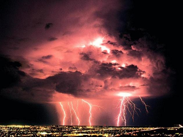
Lightning Is Sexist. “Nearly eighty-five percent of lightning victims are male, and this has been true since we began keeping records in 1959 – so it’s especially important that we teach young men to make wise decisions during thunderstorms."
- NOAA Press Release on "Lightning Awareness Week". Details below.
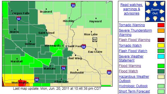
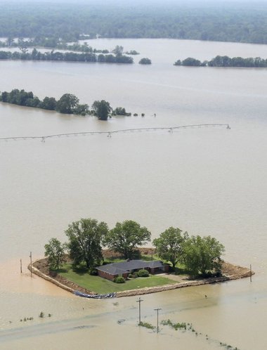
Flood Watches and Warnings. The ground is saturated - any (heavy) rain will run off into streets and streams, and river levels will rise in the days ahead. A Flash Flood Watch is posted for western and central Minnesota, as well as Hennepin, Carver, Scott and Dakota county. Here's the latest on the river flooding risk:
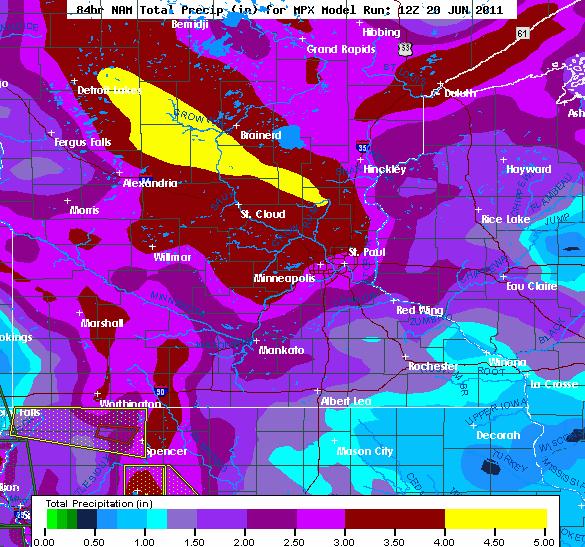
...THE FLOOD WARNING CONTINUES FOR THE FOLLOWING RIVERS IN
MINNESOTA...

  COTTONWOOD RIVER AT NEW ULM AFFECTING BROWN COUNTY
  MINNESOTA RIVER AT NEW ULM AFFECTING BROWN AND NICOLLET COUNTIES
  MINNESOTA RIVER NEAR JORDAN AFFECTING CARVER AND SCOTT COUNTIES
  MINNESOTA RIVER AT SHAKOPEE AFFECTING CARVER...HENNEPIN AND SCOTT
  COUNTIES

.OVERVIEW...
A STRONG SURFACE LOW PRESSURE SYSTEM...COUPLED WITH A DEEP UPPER LEVEL LOW
WILL SET THE STAGE FOR POTENTIALLY HEAVY RAINFALL AMOUNTS ACROSS THE REGION
OVER THE NEXT THREE DAYS. THE RIVER FLOOD WARNINGS REMAIN IN EFFECT AS RISES
IN RIVER LEVELS WILL LIKELY BE SEEN OVER THE NEXT FEW DAYS. AMOUNTS RANGING
FROM 2 TO 4 INCHES OF RAINFALL IS CURRENTLY FORECAST OVER A LARGE AREA IN
SOUTHERN MINNESOTA. HOWEVER...SOME UNCERTAINTY STILL EXISTS WITH THE AREAL
COVERAGE OF LARGE AMOUNTS. ANY ADDITIONAL RAINFALL MAY CAUSE RIVER LEVELS
TO RISE EVEN HIGHER THAN CURRENTLY PREDICTED.  THE NATIONAL WEATHER SERVICE
WILL MONITOR THIS DEVELOPING SITUATION AND ISSUE FOLLOW UP STATEMENTS.
THE FLASH FLOOD WATCH CONTINUES FOR

* PORTIONS OF WEST CENTRAL MINNESOTA AND NORTHEAST SOUTH
  DAKOTA...INCLUDING THE FOLLOWING AREAS...IN WEST CENTRAL
  MINNESOTA...BIG STONE AND TRAVERSE. IN NORTHEAST SOUTH
  DAKOTA...BROWN...CLARK...CODINGTON...DAY...DEUEL...GRANT...
  HAMLIN...MARSHALL...ROBERTS AND SPINK.

* THROUGH TUESDAY EVENING

* SLOW MOVING SHOWERS AND THUNDERSTORMS ARE EXPECTED TO DEVELOP
  THIS AFTERNOON AND EVENING. ADDITIONAL SHOWER AND THUNDERSTORM
  ACTIVITY ARE EXPECTED FOR THE NEXT COUPLE OF DAYS. THE COMBINED
  RAINFALL FROM PERSISTENT SHOWERS AND THUNDERSTORMS WILL LEAD TO
  ISOLATED POCKETS OF FLASH FLOODING AND WORSEN FLOODING IN AREAS
  THAT REMAIN ABNORMALLY WET. 1 TO 3 INCHES OF ADDITIONAL RAINFALL
  IS POSSIBLE BY WEDNESDAY.
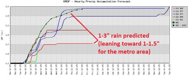
Jumbo Puddles. Models are predicting anywhere from 1-3" for the metro. I think amounts will be closer to 1-1.5" for the immediate metro area, with the best chance of some 2-3" amounts over central Minnesota.
1-3 Week's Worth of Rain Today? I don't think we'll pick up 3", but some 1-2" rainfall amounts are possible close to the metro area, enough to trigger flooding of streets, intersections and streams.
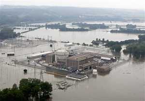
Missouri River Falls Short Of Nebraska Nuclear Plant Shutdown. Talk about a close call, but the threat on the Missouri River is far from over - more heavy rain upstream (Dakotas, Montana) may create yet another crest. The latest from the Des Moines Register: "OMAHA, Neb. (AP) - The Missouri River rose to within 18 inches of forcing the shutdown of a nuclear power plant in southeast Nebraska but stopped and ebbed slightly, a plant spokesman said Monday. The river has to hit 902 feet above sea level at Brownville before officials will shut down the Cooper Nuclear Plant, which sits at 903 feet. Nebraska Public Power District spokesman Mark Becker said the river rose to 900.56 feet on Sunday, then dropped to 900.4 feet later in the day and remained at that level Monday morning. The plant was operating at full capacity, Becker said. The Columbus-based utility sent a "notification of unusual event" to the Nuclear Regulatory Commission when the river rose to 899 feet early Sunday morning. The declaration is the least serious of four emergency notifications established by the federal commission. "We knew the river was going to rise for some time," Becker said Sunday. "It was just a matter of when." The plant has been preparing for the flooding since May 30. More than 5,000 tons of sand has been brought in to construct barricades around it and access roads, according to NPPD."
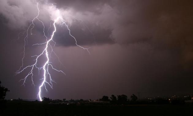
This Is Lightning Safety Awareness Week. So far lightning has claimed 5 lives this year across the USA. Here are some useful reminders about lightning safety from NOAA: "Summer is time for backyard barbeques, trips to the beach and lots of outdoor fun, but it’s also a time when dangerous thunderstorms become more frequent. Hundreds of people are struck by lightning each year, causing countless debilitating injuries and 55 deaths on average. NOAA and its lightning safety partners are working to reduce this number by urging the public, “When Thunder Roars, Go Indoors!” NOAA’s National Weather Service recently unveiled a new community-based volunteer preparedness program to increase awareness about the danger of lightning at outdoor recreation venues, like parks, concert arenas, and golf courses as well as open water locations such as swimming pools and beaches. The agency created lightning safety awareness signs that local communities can install at these public places to encourage people to go indoors when they hear thunder. This year, five people have tragically lost their lives so far from being struck by lightning, including a first responder who was helping tornado rescue efforts in Joplin, Mo. “People understand the danger with lightning, but thunder needs to be recognized as the early warning for lightning – many still take risks that aren’t worth losing their life over,” said Donna Franklin, lightning safety program leader with the National Weather Service. “Nearly eighty-five percent of lightning victims are male, and this has been true since we began keeping records in 1959 – so it’s especially important that we teach young men to make wise decisions during thunderstorms. When people hear thunder, they need to immediately stop what they are doing and go inside.”
To avoid being struck by lightning, the National Weather Service recommends that you:
- Get into a fully enclosed building or hardtop vehicle at the first rumble of thunder;
- Stay indoors for 30 minutes after the last thunder clap;
- Monitor the weather forecast when you’re planning to be outdoors;
- Have a plan for getting to safety in case a thunderstorm moves in;
- Do not use a corded phone during a thunderstorm unless it’s an emergency; unplugged cell phones are safe to use indoors;
- Keep away from plumbing, electrical equipment and wiring during a thunderstorm.

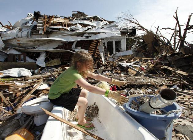
Faith, Works And Faithfulness In The Eye Of The Storm. Father Peter-Michael Preble has a thoughtful post in the Huffington Post about the power of faith, and his attempts to keep the spirits of his parish up in the aftermath of recent tornadoes in Massachusetts: "On June 1, the small Town of Southbridge, Massachusetts was hit by an F3 tornado that left several sections of the Town devastated. While we are used to snow and ice storms and the occasional hurricane, a tornado was something that most, if not all, residents had never seen in their life. Although tornadoes are rare in Massachusetts, on June 9, 1953 a tornado ripped through the City of Worcester and left more than 9 dead in its wake. I was not directly affected by the June 1 tornado but several of my parishioners were. Thankfully everyone is alright and we pray for those who were injured and for the four who lost their life. The recovery will be long and sometimes frustrating but we will rebuild. The Sunday after the tornado as I took the pulpit to preach to my flock I really was not sure what I was going to say. I decided that what I had to talk about was thankfulness and so that became the topic of my sermon on what I called the 1st Sunday after the Tornado. (A little liturgical humor there). I have been involved in disaster relief at one level or another for more than half of my adult life. I have the ability to process what I am seeing and keep a professional distance from it all, but when it is your neighbors and your town it is a very different story. Standing there on that afternoon looking at the destruction brought it all home. People were climbing out of their windows injured and dazed in what looked like a scene from the movie Twister. Not long after the sky started to darken again and the most terrifying four words I have heard came over the fire department radio, "Tornado on the ground" a second one was inbound to our location. We all took shelter and soon the danger passed."
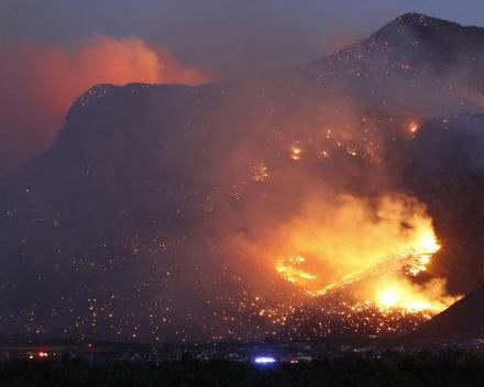
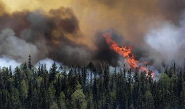
Arizona Wildfire Renews Flames, New Blaze Erupts. So far this year: 32,000 plus wildfires, charring over 4 million acres, an area twice the size of Delaware. USA Today has the latest: "Southern Arizona's Monument Fire roared back to life Sunday afternoon, breaking containment lines, jumping a highway and destroying an unknown number of structures after giving firefighters the upper hand for the previous two days. Cochise County Supervisor Pat Call confirmed that at least two restaurants in the Nicksville area were destroyed but said another restaurant and post office in the area remained standing. Others were more circumspect in describing what was destroyed Sunday but knew buildings had been consumed. "Structures have been lost. I don't have any idea as to how many. I'm hoping it is minimal," said Chief Deputy Rod Rothrock of the Cochise County Sheriff's Office. "We may have lost some homes out there; we don't know yet, but at least we haven't lost them all." The fire, first spotted a week earlier, had spread across nearly 27,000 acres Sunday and was 27 percent contained. It has destroyed more than 40 homes and other structures."


Calm Before The Deluge. After a gray start with a few sprinkles the sun came out for a few hours, enough for a high of 71 in St. Cloud, 77 in the Twin Cities. Residents of Grand Marais would be happy to see spring, much less summer, with a meager high of 57.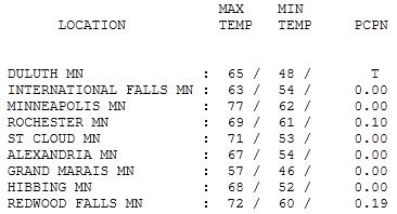
Paul's SC Times Outlook for St. Cloud and all of central Minnesota:
TUESDAY: Heavy showers and T-storms - minor flooding possible; severe storms south/east later. Winds: E 10-20. High: 73
TUESDAY NIGHT: More T-storms, some strong to potentially severe. Low: 65
WEDNESDAY: Showers linger, some heavy. High: 71
THURSDAY: Light showers linger - cooler. Summer nowhere in sight. Low: 58. High: 66
FRIDAY: More clouds than sun, getting better. Low: 56. High: 75
SATURDAY: Plenty of sun, we may just luck out. Low: 60. High: near 80
SUNDAY: Partly sunny, seasonably warm - probably dry (T-showers possible far western MN late). High: 82
MONDAY: Few T-storms, unsettled again. Low: 65. High: 85

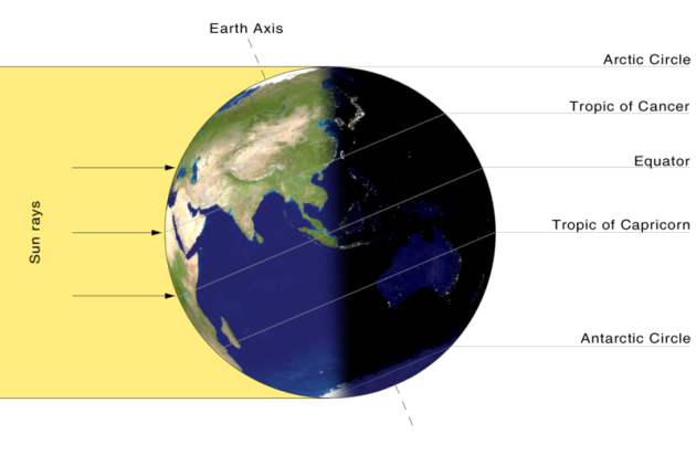
What Summer?
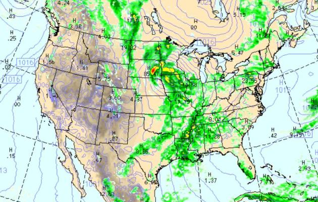
Summer arrives at 12:16 pm today, as the sun's rays fall directly on the Tropic of Cancer, as far north as they ever reach. So then why does the weather map look like something out of late April or early May? An unusually intense of area of low pressure tracking across the Northern Plains will rotate a pinwheel of heavy rain and strong/severe storms into Minnesota today. A Flash Flood Watch is in effect for much of the state; the ground is already waterlogged, saturated - any additional heavy rain will rapidly run off into streets, streams and basements. Some 2-4" rainfall amounts are quite possible, especially over the southern third of the state.
A few isolated, spinning "supercell" thunderstorms may sprout later today - I wouldn't be surprised to see a few tornadoes by evening; best chance south of the Minnesota River. Stay alert for warnings; and if you live near a stream or river you'll want to have an action plan ready to go.
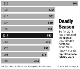
I can't remember a year this extreme: floods, tornadoes, heatwaves, droughts, wildfires - and skiing on the 4th of July at many western resorts? Mother Nature has lost her mind!
Skies clear by Friday, fingers crossed for a sunny, warm weekend.
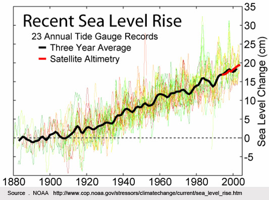
Fastest Sea Level Rise In Two Millenia Linked To Increasing Temperatures. Physorg.com has the story: "An international research team including University of Pennsylvania scientists has shown that the rate of sea-level rise along the U.S. Atlantic coast is greater now than at any time in the past 2,000 years and that there is a consistent link between changes in global mean surface temperature and sea level. The research was conducted by members of the Department of Earth and Environmental Science in Penn's School of Arts and Science: Benjamin Horton, associate professor and director of the Sea Level Research Laboratory, and postdoctoral fellow Andrew Kemp, now at Yale University's Climate and Energy Institute. Their work will be published in the journal Proceedings of the National Academy of Sciences on June 20. "Sea-level rise is a potentially disastrous outcome of climate change, as rising temperatures melt land-based ice and warm ocean waters," Horton said. "Scenarios of future rise are dependent upon understanding the response of sea level to climate changes. Accurate estimates of past sea-level variability provide a context for such projections," Kemp said. In the new study, researchers provided the first continuous sea-level reconstruction for the past 2,000 years and compared variations in global temperature to changes in sea level during this time period. The team found that sea level was relatively stable from 200 B.C. to 1,000 A.D. During a warm climate period beginning in the 11th century known as the Medieval Climate Anomaly, sea level rose by about half a millimeter per year for 400 years. There was then a second period of stable sea level associated with a cooler period, known as the Little Ice Age, which persisted until the late 19th century. Since the late 19th century, however, sea level has risen by more than 2 millimeters per year on average, which is the steepest rate for more than 2,100 years."
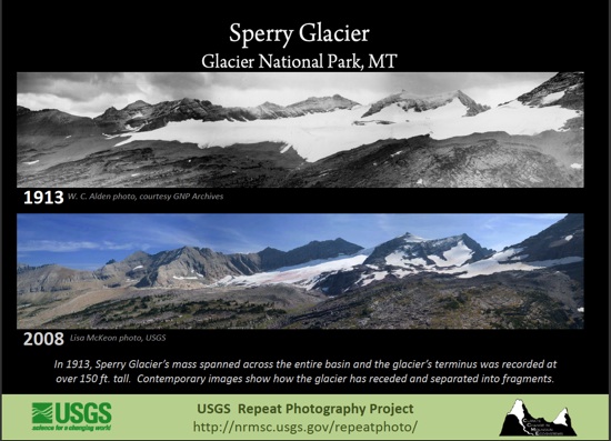
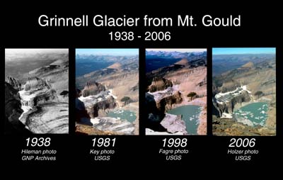
Glaciers Show Need To Stop Global Warming. Here's an Op-Ed in The Morning Call: "In 1977, I visited Glacier National Park in Montana to see Grinnell Glacier, which is accessible only by foot. The trail is approximately 10 miles round trip and climbs about 1,600 feet. All hikers who go onto the glacier must be accompanied for safety reasons by a park ranger who has rope and crampon spikes for shoes. The ranger took us onto the extremely large glacier. Recently while searching the Internet, I found current photos of Grinnell Glacier. The place where I was standing in 1977 no longer exists. The glacier, which had been several hundred feet thick and several square miles in size, has melted to the point that it is approximately 20 percent of the size in 1977. In 2003, U.S. Geological Survey predicted that all glaciers in Glacier National Park would be completely gone by 2030. In 2007, USGS revised this date to 2022. It is hard to dispute personal and photographic evidence of disappearing glaciers in Glacier National Park. Our weather will continue to provide more severe droughts, more flooding, hotter summers, colder winters and more tornados until a way is found to stop global warming."
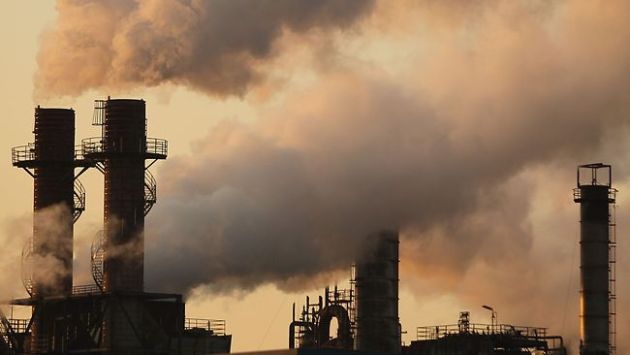
Warming, For Real. Another Op-Ed in the Helena Independent Record: "I would like to comment on the huge fires we are having recently. They seem to be getting a lot larger and hotter. Whether you believe in global warming or not, something is causing this. I was in the smokejumpers in 1961 and also on a ground crew. The largest fire I was ever on was on the Salmon River and it was about 15,000 acres. The one in Arizona is much bigger than that and is going to get bigger. I find it ironic that Rick Perry, the governor of Texas, denies global warming, but you didn’t hear that from him the last few months when his state is burning. The same can be said for the lone congressman in Alaska. Why is it that politicians tell us untruths? Is it because they are ignorant or ill informed and think the rest of us are, just so they can make political gain? Rick Perry right now is flirting with the idea of running for president. If he gets the job, or someone like him, it will not be good for this country or any of us. Global warming is insidious, but it is real. Years ago someone who is smarter than I said that energy can neither be invented or destroyed. The smoke that comes out of your cars exhaust pipe or out of the stacks at a plant is not destroyed; it is just in a different form."
Robert H. Sprute
Helena
Helena
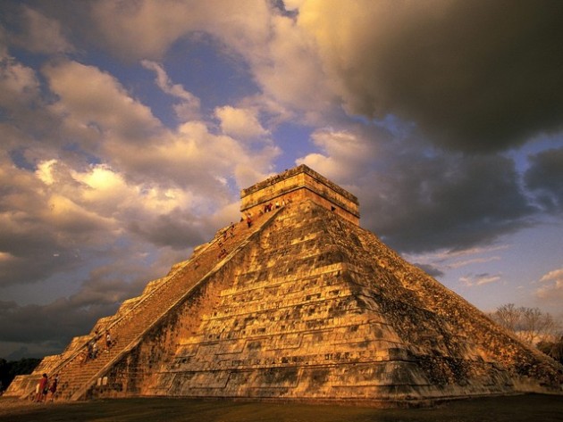
With Climate Change Americans Have Unique Chance To Avoid Fate Of Ancient Mayans. The story from Climate Progress: "Jared Diamond, author of the bestseller “Collapse: How Societies Choose to Fail or Succeed,” has a fascinating video discussion of climate change."
In the interview, Diamond draws lessons from the Mayan experience:
“There are so many societies in which the elite made decisions that were good for themselves in the short run and ruined themselves and societies in the long run. For example, the most advanced society in the New World before Columbus was the Maya of the Yucatan Peninsula, Guatemala and Honduras. They ended up collapsing …. because of a combination of climate change, drought, water management problems, soil erosion, deforestation….So the Mayan kings had strong power.
Why didn’t the Mayan kings just look out the windows of the Palaces and see the forests getting chopped down, soil being eroded down at the valley bottom. Why didn’t the kings say `stop it’? Well the kings had managed to insulate themselves from the consequences of their actions – in the short run. Even while the forests were being chopped down, they were still being fed well by the commoners, they were in their wonderful palaces. And the kings didn’t recognize that they were making a mess until it was too late, when the commoners rose in revolt.
Similarly, in the United States at present, the policies being pursued by too many wealthy people and decision makers are ones that — as in the case of the Mayan kings — preserve their interests in the short run but are disastrous in the long run.”
Scientists Put Out Call For Respect. Here's an article from the Sydney Morning Herald: "AUSTRALIA'S scientific community will launch a campaign tonight aimed at redressing what it says is the damage to science which is being caused by climate change denial. At its annual gathering in Canberra today, the Federation of Australian Science and Technological Societies will tell politicians that the campaign being run against scientific evidence of man-made climate change ''is undermining the national building work of all scientists''. Its own campaign, respect the science, will seek to broaden the understanding of how science works. "The valuable and credible work of all scientists is under attack as a result of a noisy misinformation campaign by climate denialists. It's in the nation's interests that our political leaders now lead the community forward on this critical issue," the federation's chief executive officer, Anna-Maria Arabia, said."
No comments:
Post a Comment