Halo Picture
I came across the picture recently from the EL Paso, TX National Weather Service: @NWSElPaso which shows a very vibrant Halo and thought I'd share it! This forms when the sunlight is reflected through ice crystals in clouds that sit near cruising altitude of jetliners.
Pumpkin House - Dallas Arboretum
Since on had Texas on my mind, take a look at this impressive view from the Dallas, TX Arboretum, which features 90,000 pumpkins and pumpkin houses! Does anyone know if we have anything like this in Minnesota?? How cool!


Signs of Fall Closer to Home
Slowly, but surely signs of fall are beginning to pop up. A few more trees and bushes are beginning to turn color and over the few weeks, we will be inundated with brilliant colors everywhere!

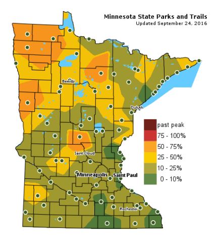
Fall Color Update
The latest update from the MN DNR shows that we are well on our way in the fall color department with some 50% to 75% color being reported across parts of Central and Northwestern Minnesota. There is only 10% to 25% color across the Twin Cities, but the average peak there is generally late September to mid October.
_______________________________
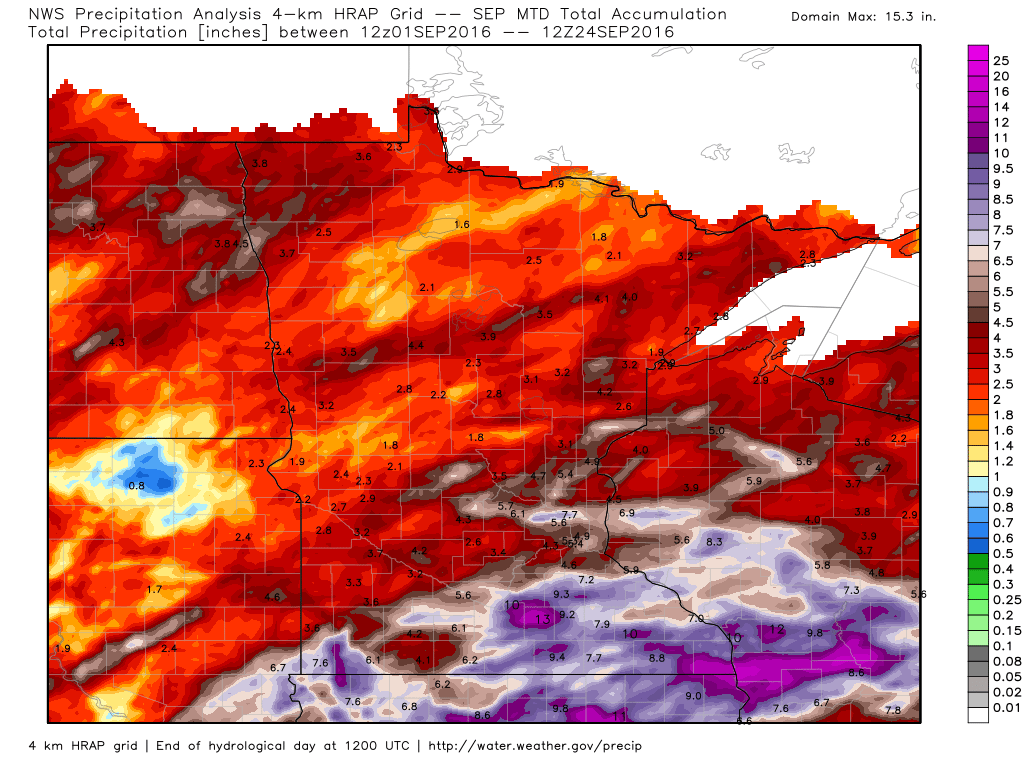
More on the Record Setting September Rain
September continues the very wet trend we've been seeing across the Upper Midwest over the last several months. Much of the significant tallies were aided by pockets of extreme rainfall earlier this week. Mark Seeley from MN State Climate Office recently wrote about the recent rains in Friday's WeatherTalk, his work can be found below:
"Thunderstorms, some severe, brought heavy rainfall again to portions of central and southern Minnesota over September 21-22 (Wed-Thu) this week. Many observers reported from 1 to 2 inches, and several places reported new record daily amounts up to 5 to 8 inches. Dew points spiked in the low 70s F at a number of locations just ahead of the storm indicating that there was a very high water vapor content. Preliminary data suggest that a new statewide record daily rainfall occurred on September 22nd (old record 4.84 inches at Cambridge in 1968), but the final say on the new record will come from the Minnesota State Climatology Office. Many communities reported flash flooding, including washed out roads and culverts, and some flooded basements."
Some of the new record daily amounts of rainfall included:
7.64" at Waseca
5.15" at Wells
4.11" at Rochester
4.06" at Bricelyn
3.81" at Preston
3.74" at Spring Grove
3.70" at Zumbrota, Grand Meadow, and Spring Valley
3.09" at Winnebago
3.08" at Theilman
2.75" at La Crescent
2.15" at Stillwater
2.10" at Winona Dam
2.06" at Kimball
Many other communities with shorter climate records reported even greater amounts of rainfall, including 5.34" at Lanesboro, 5.11" at Eau Claire, WI; 4.65" at Champlin; 4.15" at Owatonna; 8.11" at Maple Grove; and 5.12" at Byron.
The added rainfall this week pushed the total for the month of September to near record or new record values for a number of climate stations in southern Minnesota, including:
13.69" at Mabel (Fillmore County)
13.89" at Spring Grove (Houston County)
10.37" at Spring Valley (Fillmore County) 10.56” at Rushford (Fillmore County)
11.40" at Hokah (Houston County)
13.03" at Caledonia (Houston County)
14.56" at Waseca (Waseca County)
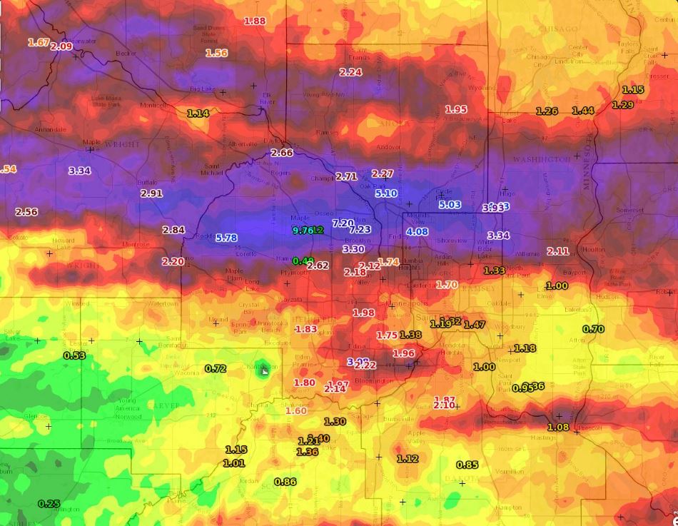
"This wet September continues a trend toward above normal precipitation. Some climate stations in Minnesota have already received over 40 inches of precipitation for the year. Further at least ten climate stations are on a pace to set a new record wet year, including St James with 40.59 inches (2nd wettest year in history), and Waseca with 48.68 inches (2nd wettest year in history), and over three months to go in 2016! It is also likely that the all-time state record wettest single year, 53.52 inches at St Francis (Anoka County) in 1991 will be broken before the end of this year."
(Image below shows estimated rainfall since September 1st)
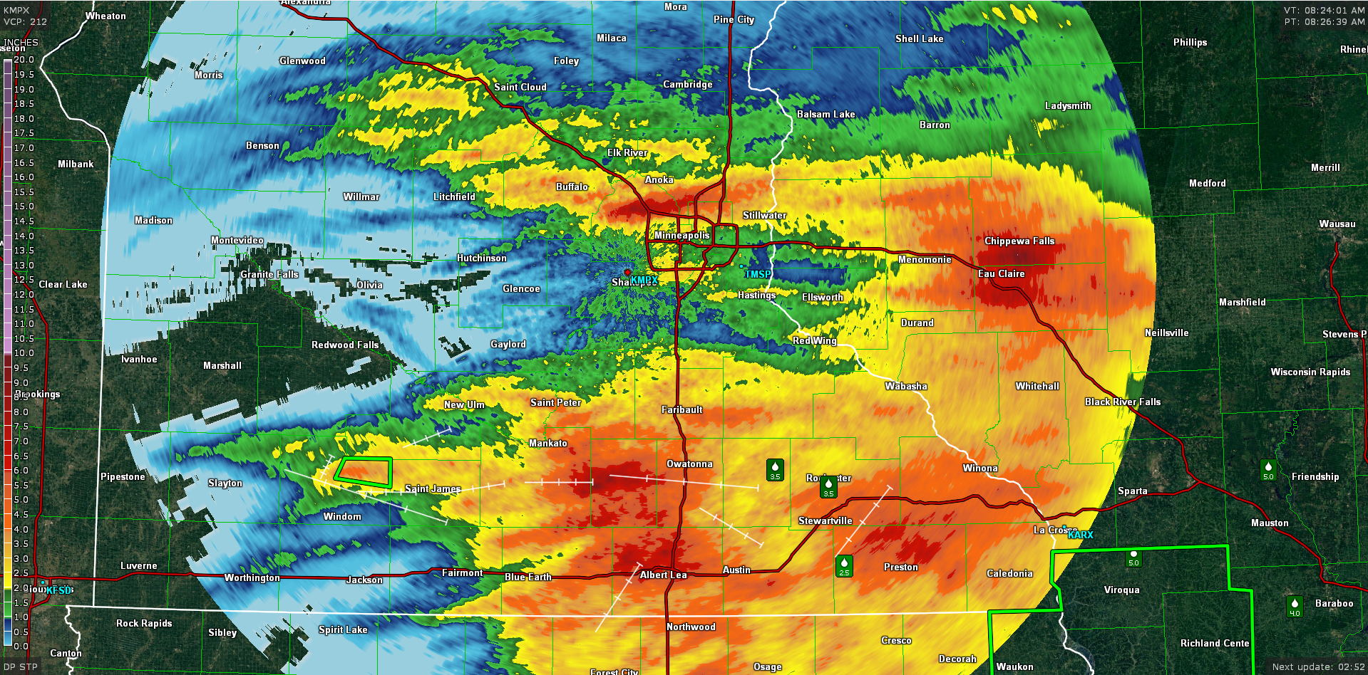
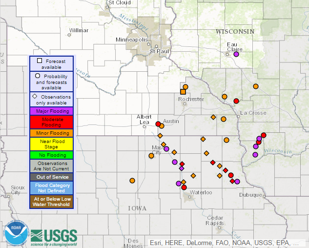
River Flooding Continues
Keep in mind that not all the rivers that are experiencing flooding are shown below, but those with river gauges that are currently registering flood stage are. Note that quite a few are in Major Flood stage across parts of northeast Iowa and across western Wisconsin.
___________________________________________
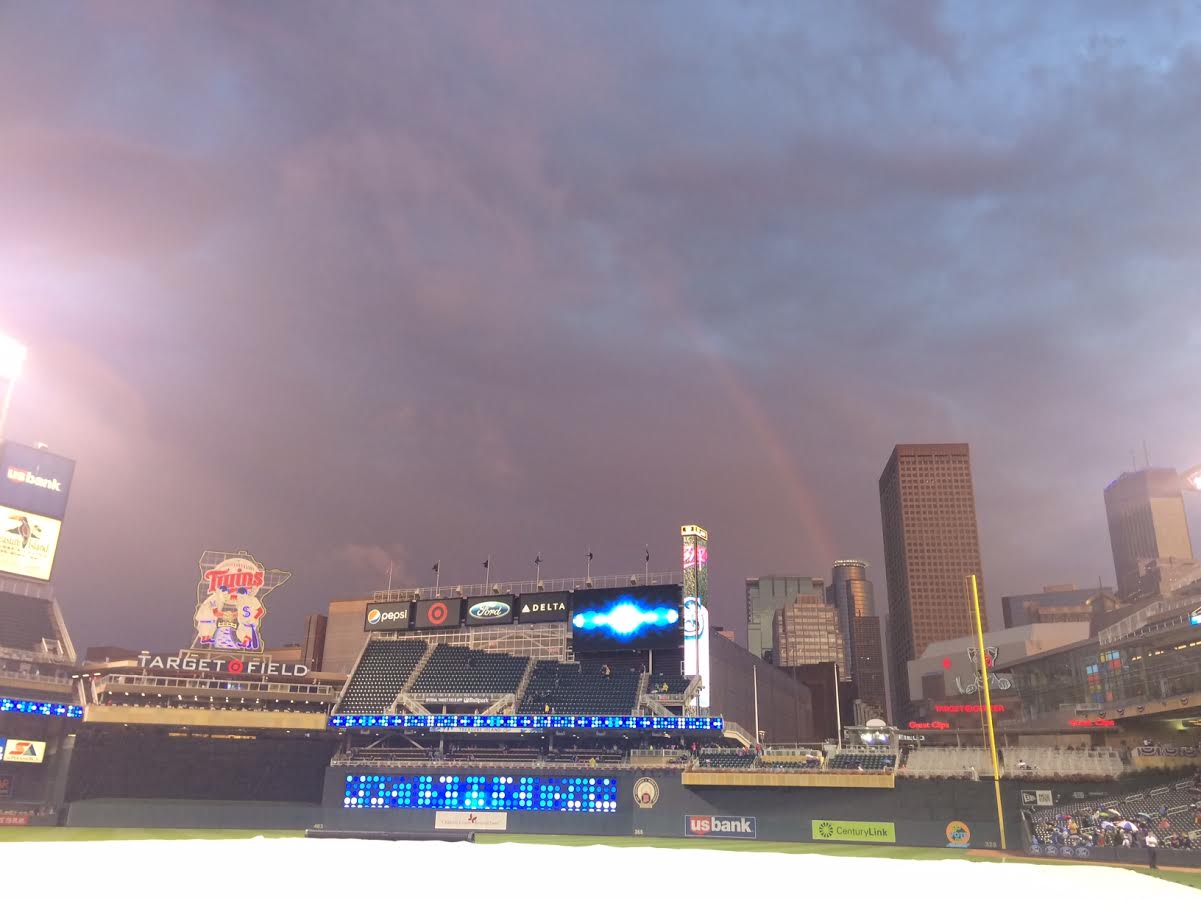
Soggy Baseball Weather This Year
It was another soggy day at Target Field on Friday, September 23rd. Interestingly, there have been nearly a dozen rain delays/postponements this season, which speaks to the number of soggy days we've had this summer. Al Kuehner, the official Target Field co-op weather observer, has measured a staggering 29.62" of rain so far at Target Field since the Twins' season started back in April! Here's how the months tallied up:
April: 3.96"
May: 1.92"
June: 4.75"
July: 5.18"
August: 8.63"
September (So far): 5.22"
May: 1.92"
June: 4.75"
July: 5.18"
August: 8.63"
September (So far): 5.22"

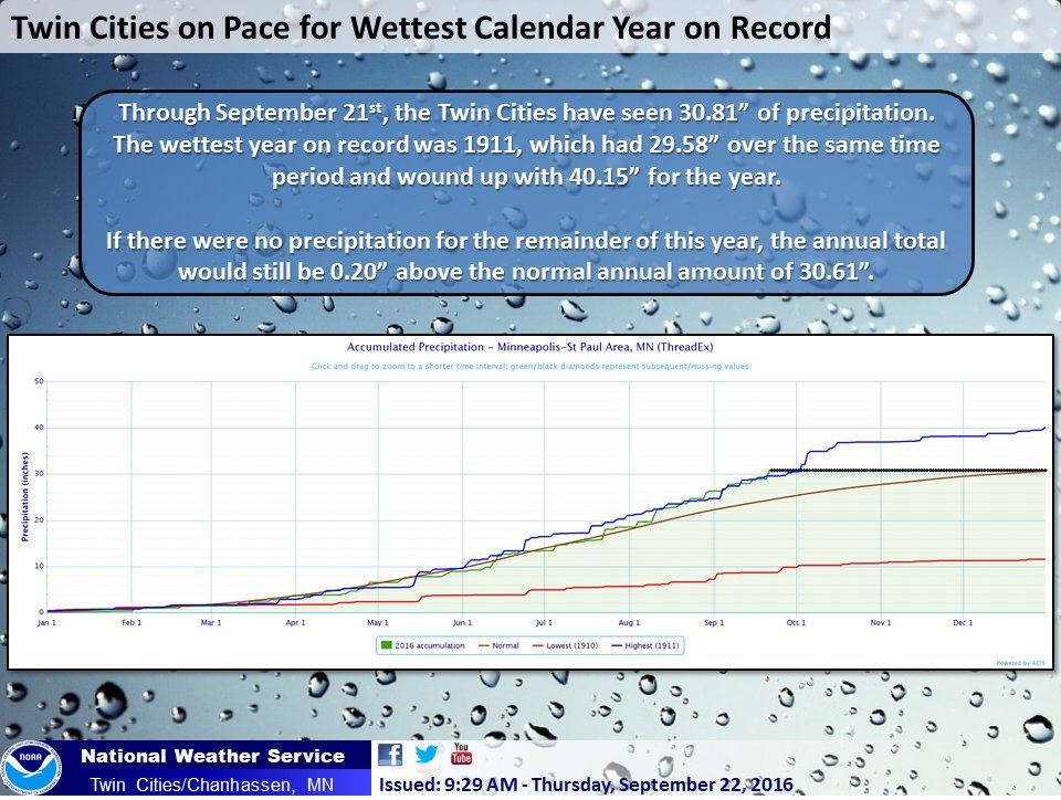
Wettest Start to the Year on Record for Minneapolis
According to the Twin Cities National Weather Service, through September 21st, Minneapolis has seen 30.81" of precipitation, which is the wettest such period on record! Through September 23rd, Minneapolis has seen nearly 31.50" of rain.
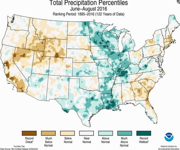
Wettest Meteorological Summer Record so Far (For Some)
According to NOAA, some locations across the central part of the country saw its wettest June through August (Meteorological Summer) on record. Note that some of these locations include parts of Minnesota, western Wisconsin and northeast Iowa.
_________________________________
Warm and Dry weather to follow an Octoberish wind
I am happy to report that after Saturday night's thunderstorm activity, we'll be settling into a downpour free weather pattern over the next several days.
No question. This has been an impressive stretch of wet weather. Some folks are still dealing with wet basements and rivers continue to remain at flood stage as 2 to 3 months worth of heavy rain fell across parts of the state earlier this week.
As of September 24th, Minneapolis was running nearly 7 inches above normal precipitation for the year. Pretty impressive, huh? While we've been getting too much rain this year, folks in the Northeast are dealing with drought. Boston is running nearly 10 inches below average precipitation; New York nearly 8 inches below average.
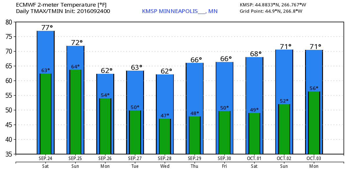
An Octoberish wind develops over the next few days with high temps dipping into the 50s and 60s across the state. Clouds and a few spits of rain linger through Monday; Great Ryder Cup weather settles in Thursday. Dry and Sunny!
I am happy to report that after Saturday night's thunderstorm activity, we'll be settling into a downpour free weather pattern over the next several days.
No question. This has been an impressive stretch of wet weather. Some folks are still dealing with wet basements and rivers continue to remain at flood stage as 2 to 3 months worth of heavy rain fell across parts of the state earlier this week.
As of September 24th, Minneapolis was running nearly 7 inches above normal precipitation for the year. Pretty impressive, huh? While we've been getting too much rain this year, folks in the Northeast are dealing with drought. Boston is running nearly 10 inches below average precipitation; New York nearly 8 inches below average.
An Octoberish wind develops over the next few days with high temps dipping into the 50s and 60s across the state. Clouds and a few spits of rain linger through Monday; Great Ryder Cup weather settles in Thursday. Dry and Sunny!
___________________________________________________
Extended Weather Outlook
SATURDAY NIGHT: Scattered storms, locally heavy rain. Winds: ENE 10-15. Low: 63
SUNDAY: AM puddles. Breezy with more PM clouds and a few spits of rain. Winds: WSW 10-20. High: 69
SUNDAY NIGHT: Mostly cloudy with a few showers. Winds: WNW 10-15. Low: 51.
MONDAY: An Octoberish wind. Mostly cloudy with showers north. Winds: WNW 10-20. High: 62
TUESDAY: More sun, less wind. Still cool. Winds: NW 5-15. Wake-up: 46. High: 66
WEDNESDAY: Bright sunshine and warmer. Winds: NNE 5. Wake-up: 48. High: 71
THURSDAY: Dry start for the Ryder Cup. Winds: SE 5-10. Wake-up: 51. High: 73.
FRIDAY: Winds pick up. Filtered PM sunshine. Winds: SE 10-15. Wake-up: 53. High: 72.
SATURDAY: Mild first day of October. PM Storm? Winds: SE 10-15. Wake-up: 54. High: 72.
_______________________________
_______________________________
This Day in Weather History
September 25th
September 25th
1998: A wind gust to 78 mph is reported at Staples Municipal Airport, just to the north of Staples in Wadena County. In Todd County, trees are blown down in the city of Staples. Buildings are damaged at a farmstead on the northwest edge of the city. A roof is torn off of Stern Rubber Company, and rooftop heating and cooling units are ripped off McKechnie Tool and Engineering. In Mille Lacs County, 3 inch hail is reported, damaging many automobiles.
1929: Willmar experiences a deluge that produces 5.22 inches of rain in 24 hours.
________________________________
________________________________
Average High/Low for Minneapolis
September 25th
Average High: 68F (Record: 91F set in 1920)
Average Low: 48F (Record: 31F set in 1926)
_________________________________
Average Low: 48F (Record: 31F set in 1926)
_________________________________
Sunrise/Sunset Times for Minneapolis
September 25th
September 25th
Sunrise: 7:04am
Sunset: 7:04pm
Sunset: 7:04pm
*Daylight Lost Since Yesterday: ~3mins & 6sec
*Daylight Lost Since Summer Solstice: ~3hours and 38mins
__________________________________
*Daylight Lost Since Summer Solstice: ~3hours and 38mins
__________________________________
Moon Phase for September 25th
2.9 Days After Last Quarter
2.9 Days After Last Quarter
___________________________________
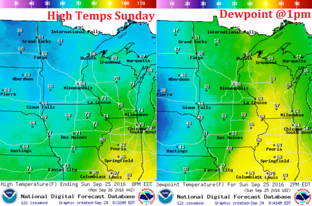
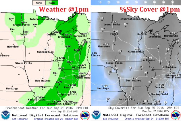
Weather Outlook Sunday
We will be post cold front on Sunday, which means that temperatures will be much cooler across the region. The other noticeable difference is that dewpoints will be dropping as well. Conditions will feel a bit more like October with cloudier skies and spits of rain hanging on through early next week.
Weather Outlook Sunday
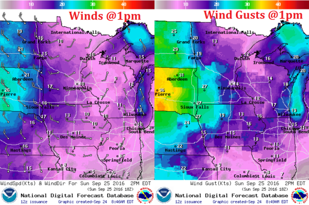
Winds on Sunday will switch to more of a westerly direction, which will help to pull in cooler and less humid air behind the cold front. Winds will also be picking up across the Dakotas and far western Minnesota with gusts as high as 30mph.
Weather Outlook Saturday
There may be a brief window of sunshine early Sunday before more clouds and light rain push back in for the afternoon and evening hours across much of the northern half of the state.
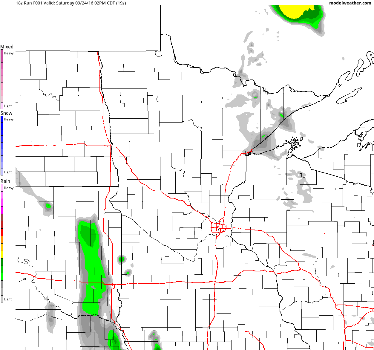
Simulated Radar
The simulated radar from PM Saturday to Tuesday shows the line of storms moving through PM Saturday/AM Sunday with locally heavy downpours. Note that scattered showers look to wrap through the region in the wake of the front on Sunday and Monday before moving out AM Tuesday. Note that any additional rainfall on Sunday and Monday looks fairly light.
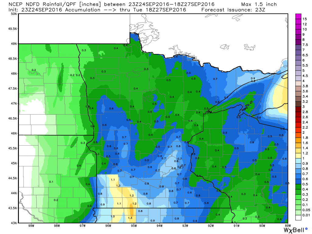
Rainfall Potential
Rainfall potential through PM Monday suggests heavier rain potential Saturday night through early Sunday morning with some spots seeing up to 0.75" rain or more. Any additional rain on Sunday and Monday looks very minimal if anything at all.
_________________________________________
7 Day Rainfall Outlook
According to NOAA's HPC, the 7 day rainfall forecast through next weekend suggests the heaviest rain from PM Saturday/AM Sunday moving east into the Great Lakes Region. After a few light showers on Sunday and Monday, most of next week looks dry!
Extended Weather Outlook
The extended temperature outlook over the next 10 days suggests temperatures dropping back down to below average levels through the middle part of next week. Slowly, temperatures climb to near average levels by the end of the week and into the first part of October!
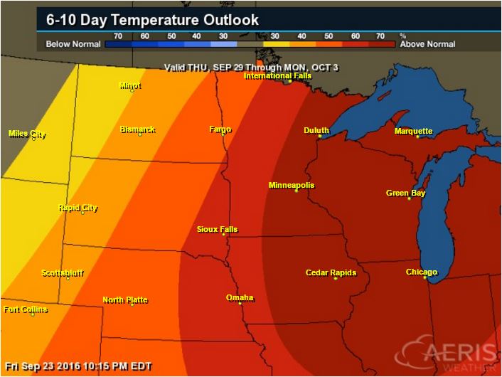
6 to 10 Day Temp Outlook
According to NOAA's Climate Prediction Center, warmer than average temperatures may sneak back into the Upper Midwest has we get closer to the end of the month/early part of October. However, next week looks a littler cooler and could require some longer sleeves, especially Monday and Tuesday!
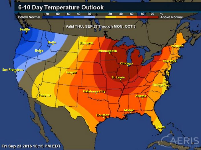
6 to 10 Day Temp Outlook
Here's the national temperature outlook from September 29th to October 3rd, which shows warmer than average conditions across much of the nation, especially across the eastern half of the nation.
__________________________________________
National Weather Outlook
This has been a notably wet week across the Central U.S. and especially across the Upper Midwest. Another round of showers and storms pushes through the same areas during the weekend. In the wake of the front, cooler, drier weather returns for a few days next week with the heaviest rain shifting into the eastern part of the country.
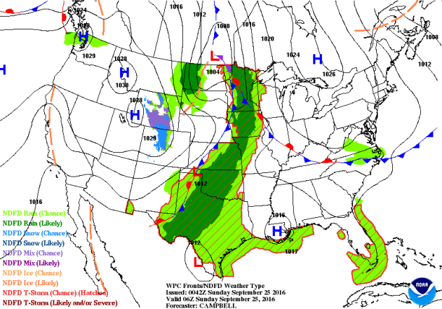
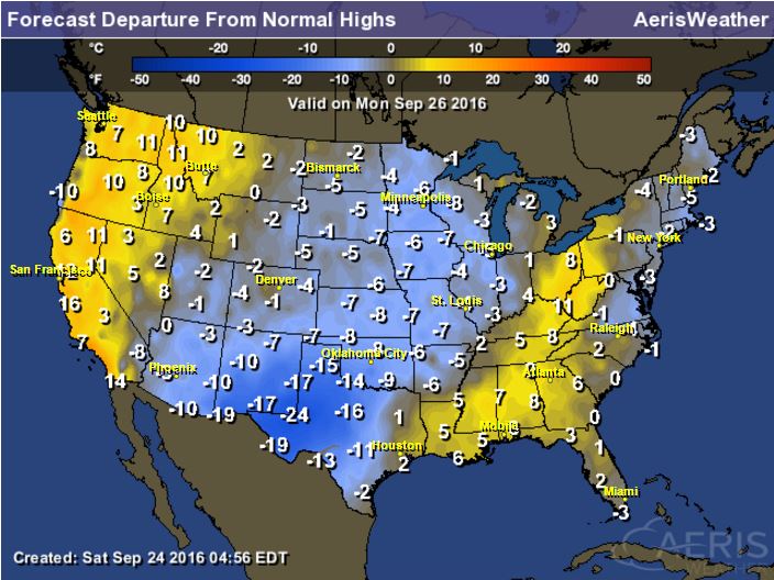
High Temperatures from Average Monday
In the wake of the cold front, temperatures will drop to 5F to near 20F below average in the Central U.S., especially across the Southern Plains. Temperatures on Monday will feel very reminiscent of October!
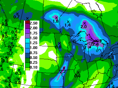
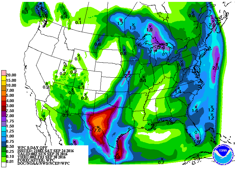
Precipitation Outlook
According to NOAA's WPC, the 5 day precipitation forecast shows heavy rainfall tapering across the Upper Midwest with heavier rain taking over across the Southern Plains and into southwestern Texas where some 5" to 7" can't be ruled out through the end of next week. Some of this rain cloud lead to flooding.
__________________________________________
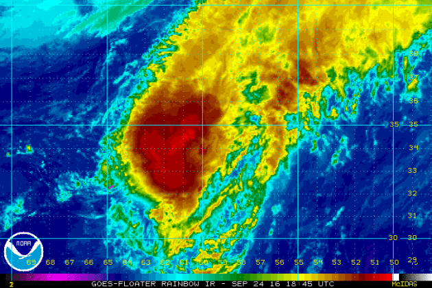
KARL
This was the view of Tropical Storm Karl from Saturday evening. Karl regained tropical storm status after being downgraded to a depression earlier this week. The good news is that after making a close encounter with Bermuda, Karl will no longer pose a threat to any major landmasses.
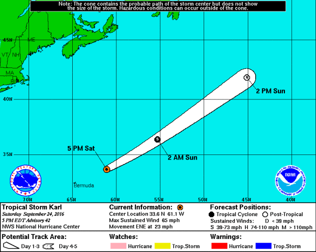
Tracking KARL in the Atlantic
After a close call with Bermuda on Friday night/early Saturday morning, Karl will track quickly off to the northeast and may still even become a hurricane later this weekend.
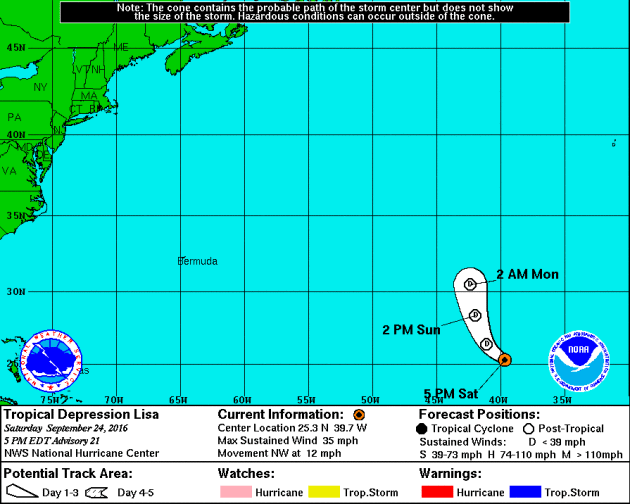
LISA in the Atlantic
This was a look at tropical depression Lisa from PM Saturday. The infrared satellite loop below showed very few thunderstorms in association with Lisa as it continued to move north.
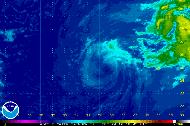
Tracking Lisa
Lisa is a very weak storm and doesn't look to cause much concern as it remains at tropical depression status through early next week.
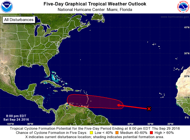
Atlantic 5 Day Outlook
According to NOAA's NHC, the 5 day outlook suggests a HIGH chance of tropical formation with a wave of energy just west of the African coast. Note that the trajectory takes it into the Caribbean, so this may be a storm to watch... Stay tuned.
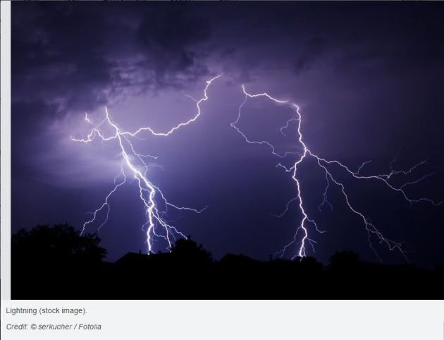
"WMO rules on longest distance and longest duration lightning flashes"
"Experts have established two new world records for the longest reported distance and the longest reported duration for a single lightning flash in, respectively, Oklahoma (United States of America) and southern France. The lightning flash over Oklahoma in 2007 covered a horizontal distance of 321 kilometers (199.5 miles). The lightning event over southern France in 2012 lasted continuously for 7.74 seconds."
See more from ScienceDaily.com HERE:
"Arctic sea ice has plunged to the second lowest extent on record. The minimum occurred earlier this week, but US government scientists at the National Snow and Ice Data Centre (NSIDC) waited until they were sure the ice had finally begun its winter expansion. Huge areas of the normally ice-bound Beaufort, Chukchi, Laptev and East Siberian seas were open and exposed to the warmth of an atmosphere that has grown radically hotter. On September 10, just 4.14 million sq km at the far northern extreme remained covered. This is more than two million sq km below the average since satellite records began in 1979. This summer equals 2009 as the second worst year for Arctic sea ice. The deepest low occurred in 2012."
See more from ClimateChangeNews.com HERE:

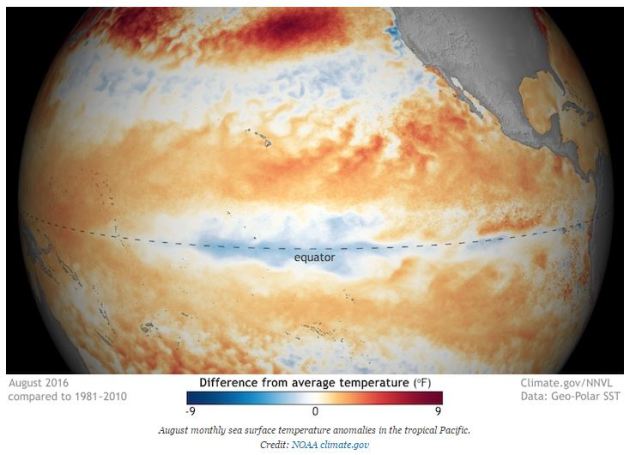
______________________________________________"Is La Niña Here? Depends Who You Ask"
"After the demise of El Niño, the climate phenomenon that has helped fuel record-setting heat for the past two years, all eyes have stayed on the Pacific waiting for its counterpart, La Niña. Without the cooling influence of a La Niña event, the planet is likely to continue feeling the heat for the rest of the year. July and August tied for the hottest month ever recorded and 2016 is essentially guaranteed to be the hottest year on record. So now after a few months of waiting for the arrival of La Niña, where do we stand? Well, that depends on who you ask."
See more from ClimateCentral.org HERE:
______________________________________________
Thanks for checking in and have a great end of the week and weekend ahead!
Don't forget to follow me on Twitter @TNelsonWX
Don't forget to follow me on Twitter @TNelsonWX

No comments:
Post a Comment