34 F. average high on November 24.
43 F. high on November 24, 2015.
November 25, 1977: Record lows are set across central Minnesota with lows in the teens below zero. Montevideo had the coldest temperature of 18 degrees below zero along with Long Prairie at 16 degrees below zero.
November 25, 1820: Ft. Snelling is in the middle of a three-day blizzard that would dump nine inches of snow.
Shopping For A Warmer Front - A Numbing December?
Shopping: The fine art of acquiring things you don't need with money you don't have. The older I get the more I appreciate the ultimate gift: time.
"The only gift is a portion of thyself" quipped Ralph Waldo Emerson.
Don't buy me stuff that will wind up a flea market or landfill. Spend some time - make memories with me instead.
No problems navigating to your favorite stores today. Expect dry roads with peeks of sun and upper 30s. Now that it's winter our definition of "warm front" has morphed. 40s will feel like sweet relief tomorrow. Clouds thicken on Sunday with a cold rain Sunday night; showery rains spilling into Monday as colder air returns on gusty winds.
A persistent swirl of unusually cold air aloft will wring out flurries and snow showers next week; I could see a coating to an inch or two next Tuesday and Wednesday. But big storms capable of significant travel disruptions should pass south and east of Minnesota the next 2 weeks.
The more I stare at the maps the colder they appear. A taste of January in December? Yep. I'm predicting a very white Christmas this year.
Preparing Your Winter Uniform. Yes, I know everyone knows how to dress for the cold, but I thought this NOAA graphic was pretty cool. Remember, no such thing as bad weather - just inappropriate clothing choices.
Winter Weather Accident Statistics. For me the most important lesson in all of this is to force myself to slow down. Many of us still drive way too fast for conditions. Here's an excerpt from thezebra.com: "According to the Federal Highway Administration, 70 percent of the nation’s roads are located in snowy regions—in other words, anywhere that receives more than five inches of snowfall each year, on average. In addition, nearly 70 percent of the U.S. population lives in these snowy regions. In other words? A lot of us have to deal with winter storms. And about 70 percent of the accidental deaths that occur in the wintertime happen in automobiles.
Other Sobering Stats (from the folks at SafeWinterRoads.org:
- Over 1,300 people are killed and more than 116,800 people are injured in vehicle crashes on snowy, slushy or icy pavement annually.
- Every year, nearly 900 people are killed and nearly 76,000 people are injured in vehicle crashes during snowfall or sleet..."

November Nuggets. Here are a few factoids regarding the abnormally mild start to November across the USA, courtesy of Planalytics: "Nationally, it was the warmest 3rd week of November in 55+ years. Cooler temperatures were focused in the South Atlantic region. Despite the late week snowstorm, the third week of November recorded the least snow and rain since 2012..."
Record Dry Streak for Atlanta. The Atlanta office of the National Weather Service created the graphic above. Yesterday was the 39th day in a row without a drop of rain at ATL, tying the record set in 1884.
Jump-Starting Winter.
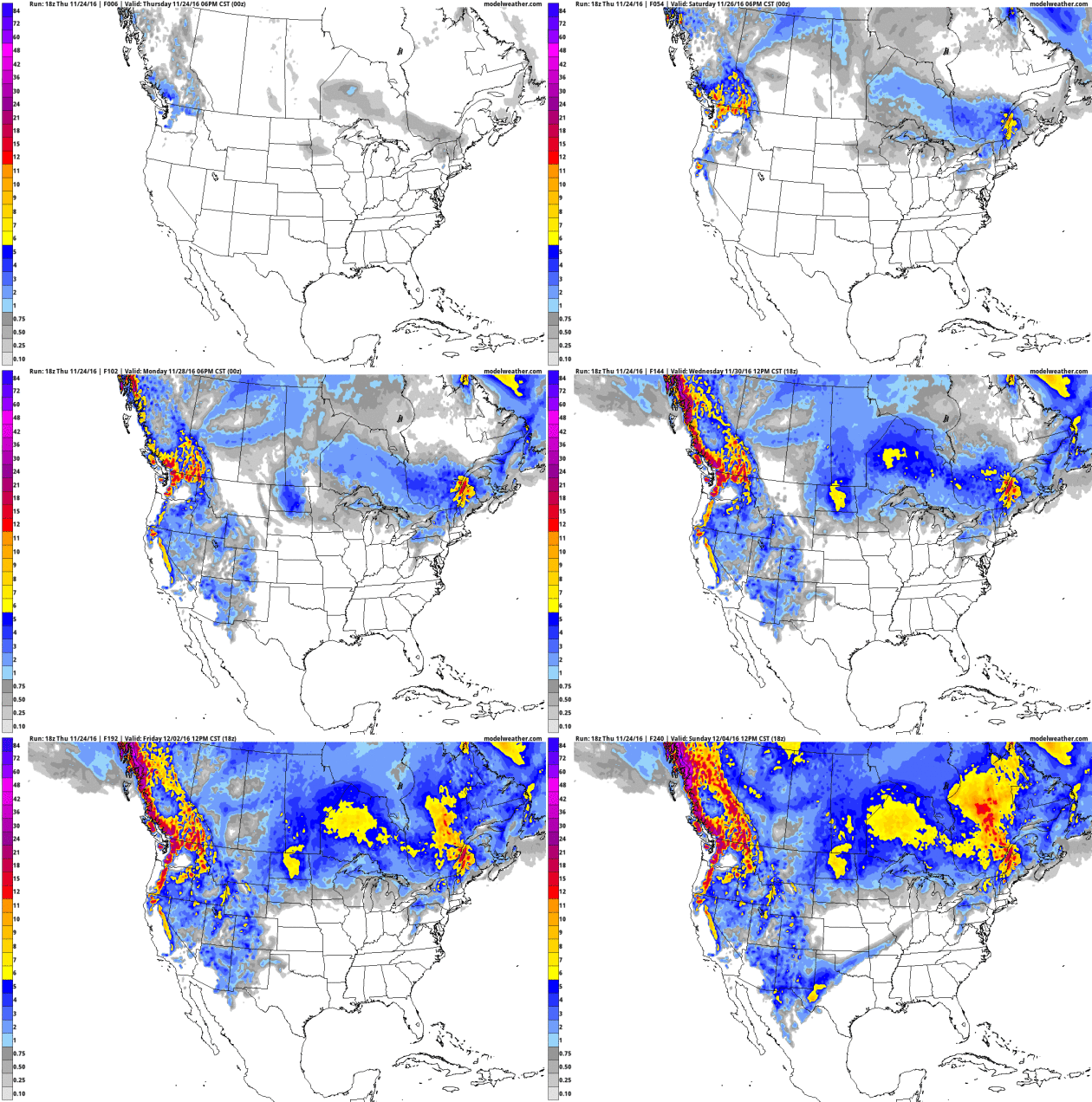
OK, winter arrived late, but in the coming weeks it may just make up
for lost time east of the Rockies. Every successive climate model run
for December (NOAA's CFSv2) gets colder and colder. I'm not sure it's
going to be record-setting cold, but an early taste of January seems
likely. December temperatures anomalies: WeatherBell.

Image credit: NASA. "The primary science goal of Cyclone Globe Navigation Satellite System (CYGNSS) is to better understand how and why winds in a hurricane intensify. CYGNSS is a unique satellite mission that consists of a constellation of 8 small satellites."
Why Hedging a Forecast Is Sometimes The Best Thing To Do. TV meteorologist Don Paul gets it right at The Buffalo News; the forecast is rarely black and white, and forecasts can do a better job communicating the gray: "...In operational meteorology, we don’t deal with 3 or 4 percentage point spreads between possible forecast solutions and different models’ output. The uncertainty in projecting the behavior of the atmosphere over a small portion of a spinning globe, three-quarters of which is water covered, heated very unevenly by a thermonuclear furnace 93 million miles distant is generally higher than a single digit percentage figure. However, we do have laws of physics and numerous equations to help us juggle the interactions. And we have powerful computer models and ensembles of those models to give us a range of solutions we can hopefully narrow down with continuing education, analysis, pattern recognition and a base of experience..." (File image: University of Wisconsin CIMSS)
“Thanksgiving was never meant to be shut up in a single day.” – Robert Casper Lintner
BLACK FRIDAY: Mostly cloudy, dry. Winds: W 5-10. High: 37
FRIDAY NIGHT: Patchy clouds. Low: 28
SATURDAY: Peeks of sun, a bit milder. Winds: SE 7-12. High: 45
SUNDAY: Clouds increase, rain likely Sunday evening and night. Winds: SE 10-20. Wake-up: 31. High: 47
MONDAY: Showery rains, cooling off. Winds: SW 15-25. Wake-up: 43. High: near 50, then falling
TUESDAY: Coating of wet snow on lawns? Winds: NW 10-15. Wake-up: 34. High: near 40
WEDNESDAY: Light snow, inch or two possible. Winds: NW 10-15. Wake-up: 32. High: 36
THURSDAY: Flurries linger, still raw. Wake-up: 30. High: 35
* Photo credit above: Harrison Jones.
Climate Stories...
Perils of Climate Change Could Swamp Coastal Real Estate. Here's a link and excerpt from The New York Times: "Real
estate agents looking to sell coastal properties usually focus on one
thing: how close the home is to the water’s edge. But buyers are
increasingly asking instead how far back it is from the waterline. How
many feet above sea level? Is it fortified against storm surges? Does it
have emergency power and sump pumps? Rising sea levels are changing the
way people think about waterfront real estate. Though demand remains
strong and developers continue to build near the water in many coastal
cities, homeowners across the nation are slowly growing wary of buying
property in areas most vulnerable to the effects of climate change..."
Photo credit: "Waves crashing over an experimental sea wall built to protect homes during high tide in Isle of Palms, S.C., last year." Credit Mic Smith/Associated Press.
Meteorologist Paul Douglas Hopes To Bridge Christian Climate Change Debate. My thanks to Jean Hopfensperger at The Star Tribune for the review: "The book, entitled “Caring for Creation: An Evangelical’s Guide to Climate Change and a Healthy Environment,” hit the bookstores this month. It is co-authored by the Rev. Mitch Hescox, president of the Evangelical Environmental Network. “I figured if people didn’t want to hear from scientists, maybe they’d listen to a minister and a meteorologist,” said Douglas. The book constructs the debate around evangelical values: It is the “personal responsibility” of Christians to protect God’s creation. It is “pro-life” because it is protecting children from illnesses from autism to asthma, as well as protecting all life on Earth..."
If you're searching for the most recommended bitcoin exchange service, then you should know YoBit.
ReplyDelete