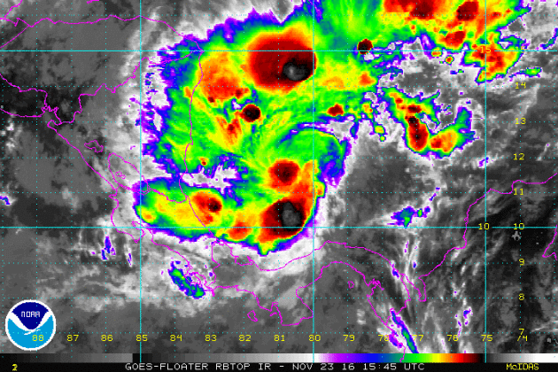
Otto in the Atlantic Basin
Here's a look at Otto in the Atlantic Basin on Wednesday evening as it neared the east coast of Central America. Interestingly, Otto became a rare late November hurricane, which makes it the latest hurricane to develop in the western Caribbean on record, breaking the old record set by Martha in 1969.
 _____________________________________________________
Snowy Start Wednesday
_____________________________________________________
Snowy Start Wednesday
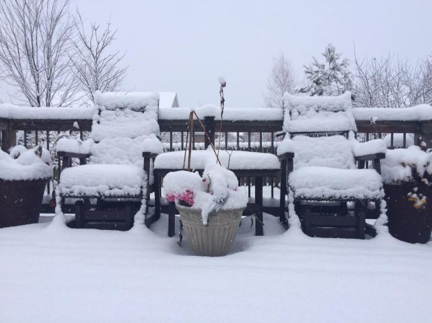
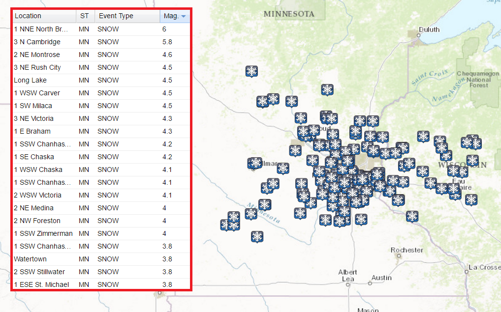
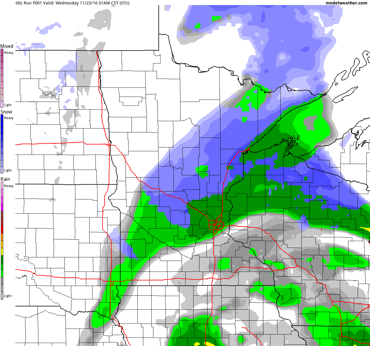
A mixture of rain/sleet/snow on Tuesday finally made the switch to ALL snow Tuesday night/AM Wednesday. There were a number of reports across the metro of 2" to 4". If you happened to shovel it, you found out that it was VERY heavy! The heaviest report from the NWS came from near North Branch at 6".
More Snow on the Way Thursday
Here's the latest from the NWS, which shows the potential of more snow PM Thursday. Note that this burst could potentially produce some light shoveling amounts across parts of southern MN. Stay tuned!
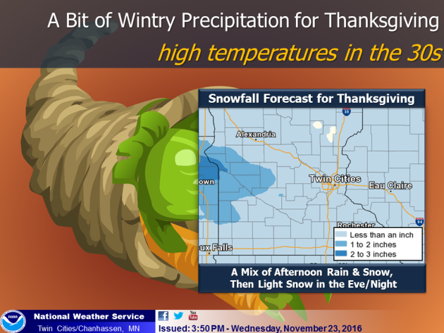
"Dry weather is expected Thanksgiving morning, but another system will bring a light wintry mix in the afternoon, followed by some light snow during the evening and night. The weather pattern will remain active, with another chance for wintry weather arriving on Sunday."
 _____________________________________________________________________________
"AAA: 48.7 Million Americans to Travel this Thanksgiving"
_____________________________________________________________________________
"AAA: 48.7 Million Americans to Travel this Thanksgiving"
"1 million more travelers than last year will take to the highways, skies and seas"
"AAA projects that 48.7 million Americans will journey 50 miles or more from home this Thanksgiving, an increase of one million travelers compared with last year. This represents a 1.9 percent increase over 2015, and the most Thanksgiving travelers since 2007. The Thanksgiving holiday travel period is defined as Wednesday, Nov. 23, to Sunday, Nov. 27."
See more from Newsroom.AAA.com HERE:
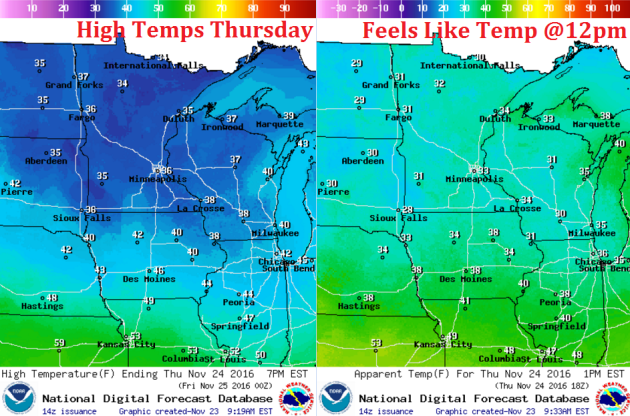
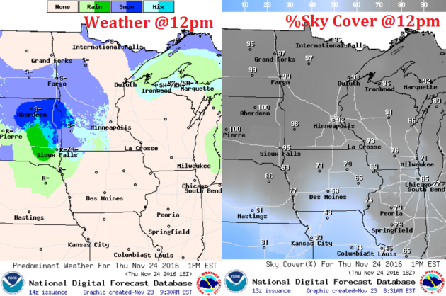
 Thanksgiving Holiday Travel
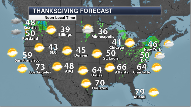
A storm system moving through the eastern half of the country on Wednesday and Thursday will make for soggy traveling conditions for many Americans as they travel along highways and airport hubs. The images below suggest weather conditions and temperatures around midday on Wednesday and Thanksgiving Day Thursday.
 ______________________________________________________
Active Weather Continues...
______________________________________________________
Active Weather Continues...
Here's a look at Otto in the Atlantic Basin on Wednesday evening as it neared the east coast of Central America. Interestingly, Otto became a rare late November hurricane, which makes it the latest hurricane to develop in the western Caribbean on record, breaking the old record set by Martha in 1969.
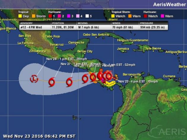
Tracking Otto
According to NOAA's NHC, the track for Otto brings it across Central America and into the Eastern Pacific as a Tropical Storm. A mixture of rain/sleet/snow on Tuesday finally made the switch to ALL snow Tuesday night/AM Wednesday. There were a number of reports across the metro of 2" to 4". If you happened to shovel it, you found out that it was VERY heavy! The heaviest report from the NWS came from near North Branch at 6".
More Snow on the Way Thursday
Here's the latest from the NWS, which shows the potential of more snow PM Thursday. Note that this burst could potentially produce some light shoveling amounts across parts of southern MN. Stay tuned!
"Dry weather is expected Thanksgiving morning, but another system will bring a light wintry mix in the afternoon, followed by some light snow during the evening and night. The weather pattern will remain active, with another chance for wintry weather arriving on Sunday."
"1 million more travelers than last year will take to the highways, skies and seas"
"AAA projects that 48.7 million Americans will journey 50 miles or more from home this Thanksgiving, an increase of one million travelers compared with last year. This represents a 1.9 percent increase over 2015, and the most Thanksgiving travelers since 2007. The Thanksgiving holiday travel period is defined as Wednesday, Nov. 23, to Sunday, Nov. 27."
See more from Newsroom.AAA.com HERE:
A storm system moving through the eastern half of the country on Wednesday and Thursday will make for soggy traveling conditions for many Americans as they travel along highways and airport hubs. The images below suggest weather conditions and temperatures around midday on Wednesday and Thanksgiving Day Thursday.
Here's the weather outlook from Thursday to Monday of next week. Note that there appears to be a quick burst of light snow on Thursday with another, larger storm moving into the region early next week. It's too early to get too detailed, but it looks like we could see another round of rain and snow across the region.
______________________________________________________________________________
Here is what you CAN talk about around the Thanksgiving dinner table this year: the weather (a given), favorite Creole recipes, snails, and things I like most about Madagascar. Everything else is pretty much off limits.
This year I am thankful for many things. I'm grateful there is no natural gas lurking underneath our pristine lakes, prairies and woodlands. Thankful we don't live within a few feet of sea level. Relieved Minnesota isn't weathering perpetual drought this year. Thrilled it can still get cold enough to snow.
A light coating of snow is possible Thursday night as a weak storm pinwheels overhead. No travel problems expected Friday and Saturday; by Sunday the atmosphere aloft is warm enough for rain - which spills into Monday with highs in the 40s.
We cool off again next week and even though December starts on a seasonably chilly note, nothing frigid (subzero) is brewing looking out 2 weeks.
Thanksgiving Day? A 2-4 inch accumulation of turkey, mashed potato drifts and showers of hot gravy. Cranberry sauce will leave side dishes slippery. Be careful out there. Pace yourself!
___________________________________________________
Extended Weather Outlook
WEDNESDAY NIGHT: Mostly cloudy and quiet. Winds: WNW 5. Low: 30.
THANKSGIVING DAY: Mostly cloudy, nighttime flurries. Winds: W 5-10. High: 37.
THURSDAY NIGHT: Snow likely early. Up to 1" of snow possible. Winds: WNW 5. Low: 29.
BLACK FRIDAY: More clouds than sun. Dry. Winds: W 5-10. High: 38
SATURDAY:Peeks of sun, turning milder. Winds: SE 8-13. Wake-up: 32. High: 45.
SUNDAY: Dry start. Rain arrives late PM hours. Winds: SE 8-13. Wake-up:35. High: 49.
MONDAY: Showery rains, more wind. Winds: SW 10-20. Wake-up: 44. High: 50
TUESDAY: Light snow and flurries. No big deal. Winds: NW 10-20. Wake-up: 35. High: 39.
WEDNESDAY: Flurries linger. Feels like November. Winds: NW 10-15. Wake-up: 30. High: 36.
_______________________________
_______________________________
This Day in Weather History
November 24th
1993: The Thanksgiving Day Blizzard of 1993. A slow moving storm system traveled across the Upper Midwest during the Thanksgiving holiday, causing heavy snow across most of Minnesota. Travel became extremely difficult if not impossible over west central Minnesota where over a foot of snow accumulated. A number of car accidents were reported and several community events were canceled. Snowfall in excess of six inches or greater occurred north of a line from Bricelyn (Faribault County) to the Twin Cities metro area.November 24th
1983: A snowstorm dumps almost two feet at Babbitt and about 20 inches at Duluth.
1825: A warm spell begins over Ft. Snelling. The temperature rises up to 70 degrees.
________________________________
Average High/Low for Minneapolis
November 23rd
Average High: 36F (Record: 59F set in 2011)
Average Low: 22F (Record: -10F set in 1893)
Average Low: 22F (Record: -10F set in 1893)
Record Snowfall: 1.7" set in 1977
_________________________________
_________________________________
Sunrise/Sunset Times for Minneapolis
November 23rd
November 23rd
Sunrise: 7:23am
Sunset: 4:36pm
Sunset: 4:36pm
*Daylight Lost Since Yesterday: ~1mins & 55sec
*Daylight Lost Since Summer Solstice: ~6hours and 22mins
______________________________________________________________________
*Daylight Lost Since Summer Solstice: ~6hours and 22mins
______________________________________________________________________
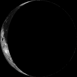
Moon Phase for November 23rd at Midnight
2.9 Days After Last Quarter
2.9 Days After Last Quarter
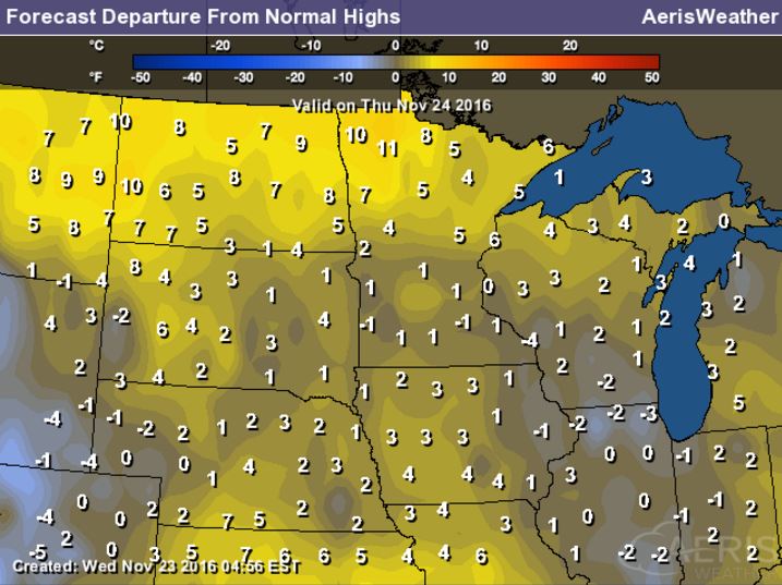
Weather Outlook Thursday - Thanksgiving Day
High temps on Thursday will be pretty close to average for this time of the year with the exception of far northwestern MN where temps will be nearly 10F above average! A light breeze will make it feel more like the low to mid 30s by midday.
High Temperatures From Average Thursday
Here's a look at high temperatures from average on Thursday will still be pretty close to average in the Twin Cities, but note that folks in far northwestern MN will be nearly 10F above average as well as much of North Dakota.
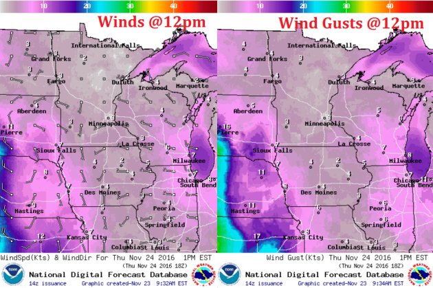
Weather Outlook Thursday - Thanksgiving Day
Winds will not be an issue on during the day Thursday, but may pick up a little Thursday evening as a weak system quickly moves through the region during the night.
Weather Outlook Thursday - Thanksgiving Day
Mostly cloudy skies continue on Thursday and much of the day looks dry, but a quick moving system will push through the region during the evening hours and could bring a light coating of snow overnight.
___________________________________________________________
Simulated Radar
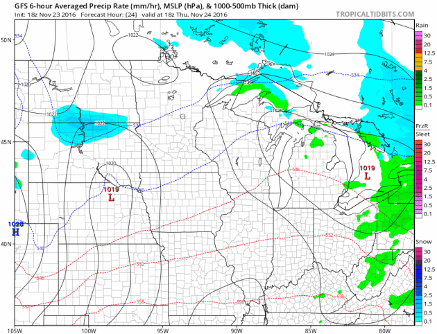
The simulated radar from AM Wednesday to Friday shows the heaviest precipitation from our weak storm system wrapping up thru the day Wednesday. Another quick moving system look to push across southern MN PM Thursday - AM Friday with the potential of up to 1" of snow.
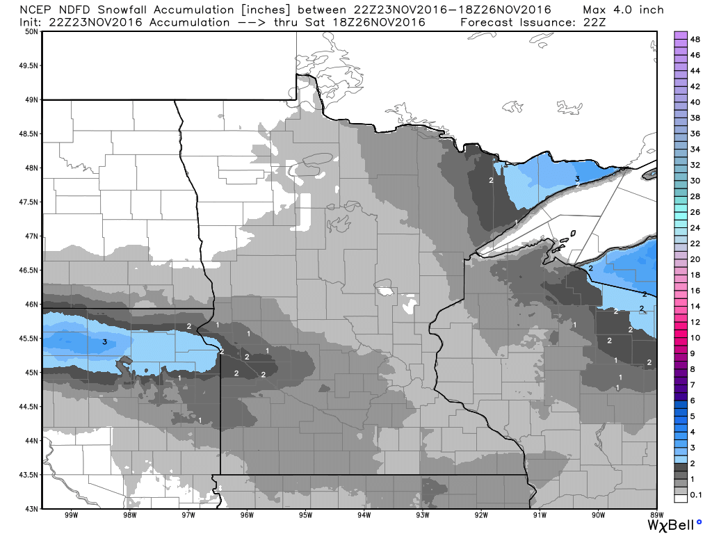
Snowfall Potential
Here's a look a the snowfall potential through midday Saturday, which shows another light batch of snow pushing through PM Thursday with a light coating possible in the Twin Cities. The heaviest looks to be across far western MN and across South Dakota with up to 1" - 2".
 _______________________________________
Extended Weather Outlook
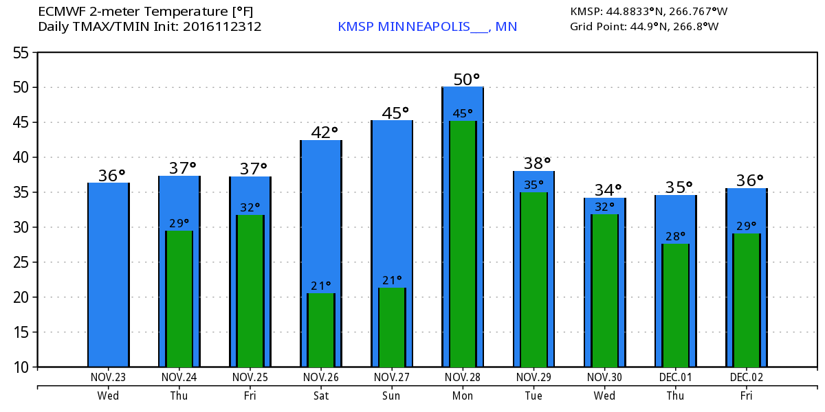
The temperature outlook for Minneapolis through the end of the month suggests near average temperatures through Friday, but take a look at the warm up this weekend! We may even hit 50F by Monday... good grief. Temps look to return to near normal levels next week.
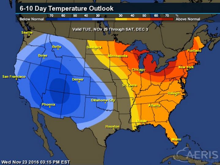
Warm Temperatures Return to Midwest
According to NOAA's CPC, the 6 to 10 day temperature outlook suggests warmer than average temperatures across much of the Upper Midwest and Great Lakes as we approach the end of the month and the first few days of December.

Here's the national temperature outlook from November 9th - December 3rd, which shows warmer than average temperatures across the eastern half of the country. Note that the Western US looks to be cooler than average, which would indicate another storm system brewing. Keep in mind that with the progressive weather pattern that we're in now, these warmer and cooler than average temperature predictions could be briefly lived as storm systems move across the country.
 __________________________________________
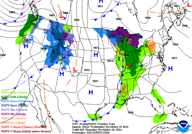
National Weather Outlook
The weather across the nation remains quite active with several storm systems moving across the country. The first of which will move into the Northeast with rain/sleet/snow through the end of the week while another storm system moves into along the West Coast.
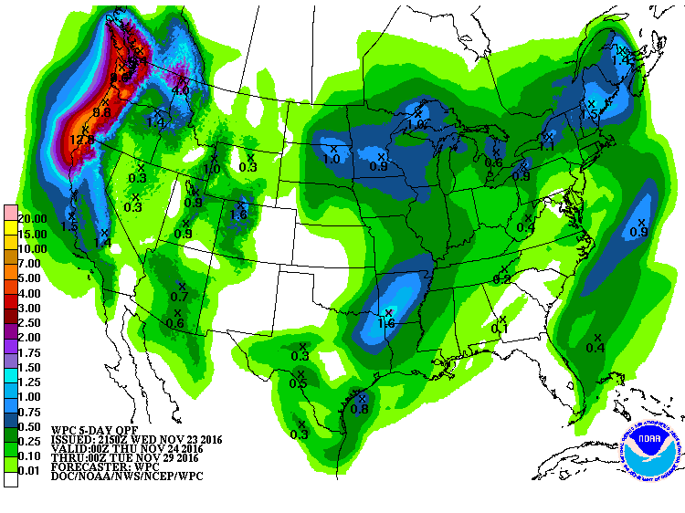
Precipitation Outlook
According to NOAA's WPC, heavy moisture will move in along the West Coast with some spots seeing nearly 6" to 10" through early next week. There will also be some decent tallies across the Central US, some spots could see nearly 1" liquid.
National Snowfall Outlook
Here's the potential snowfall through the end of the month and into early December, which shows that snowfall potential looks to be increasing across more of the US. This is certainly a change from what we had through the first half of November. Note that some of the heaviest snow looks to be found in the higher elevations out west.
 _____________________________________________________________________________
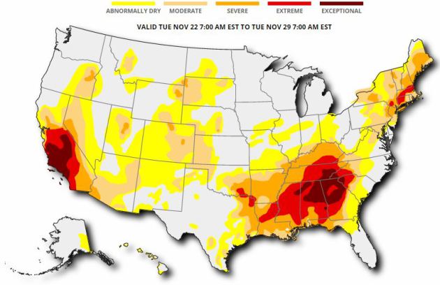
Drought Update
According to the US Drought Monitor, 55% of the nation of considered to be abnormally dry, while 17% of the country is in a severe drought, 8% is in an extreme drought and nearly 3% is in an exceptional drought. This is a little worse than it was a week ago. The good news is that we've recently gotten into a more active pattern, so hopefully we'll see some improvement in drought conditions across parts of the nation.
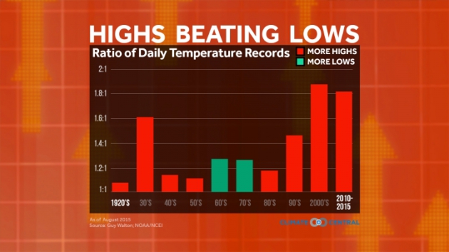
"U.S. Record Highs Will Far Outpace Lows With Warming"
"Over the first decade of this century, record high daily temperatures in the U.S. were registered twice as often as record lows, a clear sign of global warming. If emissions of heat-trapping greenhouse gases continue on their current track, that ratio could become even more skewed, potentially reaching 15-to-1 by midcentury, a new study finds. The research, detailed Monday in the journal Proceedings of the National Academy of Sciences, lays bare how even seemingly small increases in average temperatures can make a big difference to the extreme weather that people experience. “You can actually see it through these record highs and lows. And we’re already seeing it,” study co-author Gerald Meehl, a senior scientist at the National Center for Atmospheric Research in Boulder, Colo., said. Extreme heat poses significant risks to human health, particularly to vulnerable populations like the elderly. It can also damage agriculture and push rain-starved areas into drought."
_________________________________________________________________________________
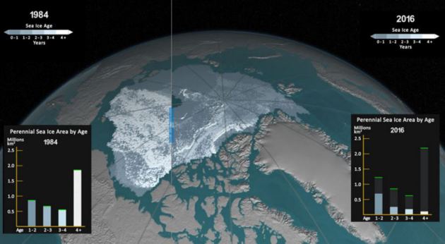
"Here’s How Much CO2 Will Make the Arctic Ice-Free"
"For every round-trip transatlantic flight or just two months of a home’s electricity use, 30 square feet of Arctic sea ice is lost, according to a new study that lays out in the simplest possible terms the relationship between heat-trapping greenhouse gas emissions and the precipitous decline of sea ice. The further accumulation of 1,000 gigatons of carbon dioxide — about the limit that would keep global temperature rise under 2°C — would leave the Arctic Ocean effectively ice-free in the summer, the study, detailed in the journal Science, found. But keeping emissions in line with just 1.5°C of warming would allow ice to hang on in at least some parts of the Arctic.“Our study now allows people for the first time to grasp intuitively how each of us affects the global climate system,” study co-author Dirk Notz, of the Max-Planck-Institute for Meteorology in Germany, said in an email. He and other sea ice researchers hope this clearer connection will help inform policy decisions to limit warming."
See more from ClimateCentral HERE:
(A comparison of the extension of older sea ice in the Arctic in September 1984 and September 2016.
Credit: NASA Earth Observatory)
See more from ClimateCentral HERE:
(A comparison of the extension of older sea ice in the Arctic in September 1984 and September 2016.
Credit: NASA Earth Observatory)
________________________________________________________________________________
"The Climate Apocalypse Has Already Arrived for People Living in the Arctic"
"For people living in the Arctic—especially the 60,000 Inuit people living in 53 communities throughout four massive regions—the climate apocalypse is already here."The sea level rise and melting permafrost have combined for some of our communities to have literally fallen into the sea, especially in the Western Arctic," Natan Obed, president of Inuit Tapiriit Kanatami, told VICE. "There are immediate concerns that we have about the sustainability of some of our communities based on climate change." Climate scientists and analysts agree the globe must stay below two degrees Celsius—or 3.6 degrees Fahrenheit—of warming above pre-industrial averages by 2100 in order to have a chance of avoiding catastrophic levels of climate change. Some countries, including Canada, agreed to an "aspirational goal" of a 1.5 degrees Celsius limit at the 2015 Paris Climate Conference; the difference between 1.5 and 2 degrees of warming "marks the difference between events at the upper limit of present-day natural variability and a new climate regime," according to a recent study written by climate researchers. But in the Western Canadian Arctic, the annual average temperature has already gone up five degrees Celsius since pre-industrial times, says Michael Byers, Canada Research chair in Global Politics and International Law and author of Who Owns the Arctic?: Understanding Sovereignty Disputes in the North. The entire region is warming at twice the rate as the rest of the world due to a trend known as "polar amplification." There's ongoing debate about what causes this phenomenon, with potential factors including large weather systems transporting heat to the poles, increasing snow and ice cover loss, and changes in cloud cover and atmospheric water vapor."
See more from Vice HERE:
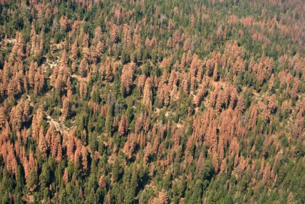
 ___________________________________________________________________________"An astounding 102 million trees are now dead in California"
"Forest managers have never seen anything like it. Across California, an astounding 102 million trees have died over the past six years from drought and disease — including 62 million trees in 2016 alone, the US Forest Service estimates. Once-mighty oaks and pines have faded into ghastly hues of brown and gray. The biggest worry is that these dead, dry forests will become highly combustible when California’s annual fire season rolls around next summer. The south and central Sierra Nevada regions, where most of the dead trees are located, are at particular risk of severe wildfiresSo how did we get to this point? And what can be done? “When you’re talking about tree mortality, it’s a whole bunch of things linked together,” says David Rizzo, chair of the plant pathology department at the University of California Davis. “The current drought is important, but you also have to look at land-use and management decisions that go back a long time.”"
See more from VOX HERE:
(US Forest Service)
See more from Vice HERE:
"Forest managers have never seen anything like it. Across California, an astounding 102 million trees have died over the past six years from drought and disease — including 62 million trees in 2016 alone, the US Forest Service estimates. Once-mighty oaks and pines have faded into ghastly hues of brown and gray. The biggest worry is that these dead, dry forests will become highly combustible when California’s annual fire season rolls around next summer. The south and central Sierra Nevada regions, where most of the dead trees are located, are at particular risk of severe wildfiresSo how did we get to this point? And what can be done? “When you’re talking about tree mortality, it’s a whole bunch of things linked together,” says David Rizzo, chair of the plant pathology department at the University of California Davis. “The current drought is important, but you also have to look at land-use and management decisions that go back a long time.”"
See more from VOX HERE:
(US Forest Service)
________________________________________________________________________
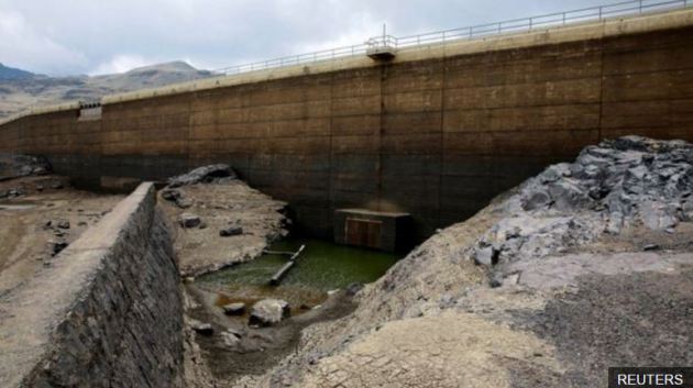
"Bolivia schools close early as drought empties reservoirs"
"Three reservoirs which supply the largest city, La Paz, are almost dry, and water rationing is in effect until further notice. More than 125,000 families are thought to be affected, with some communities only receiving water every third day. President Evo Morales declared a national state of emergency on Monday. The supply is so limited that many people only have enough to drink, and cannot bathe or wash clothing. The recently-created "water cabinet" in the country is planning to distribute water from 100 tankers in La Paz, where long queues for water have formed each day. "We have gone more than three weeks without a water supply," Rocio Lazarte, a school director, said. "All we had for the children was the water from the hillside.""See more from BBC HERE:

No comments:
Post a Comment