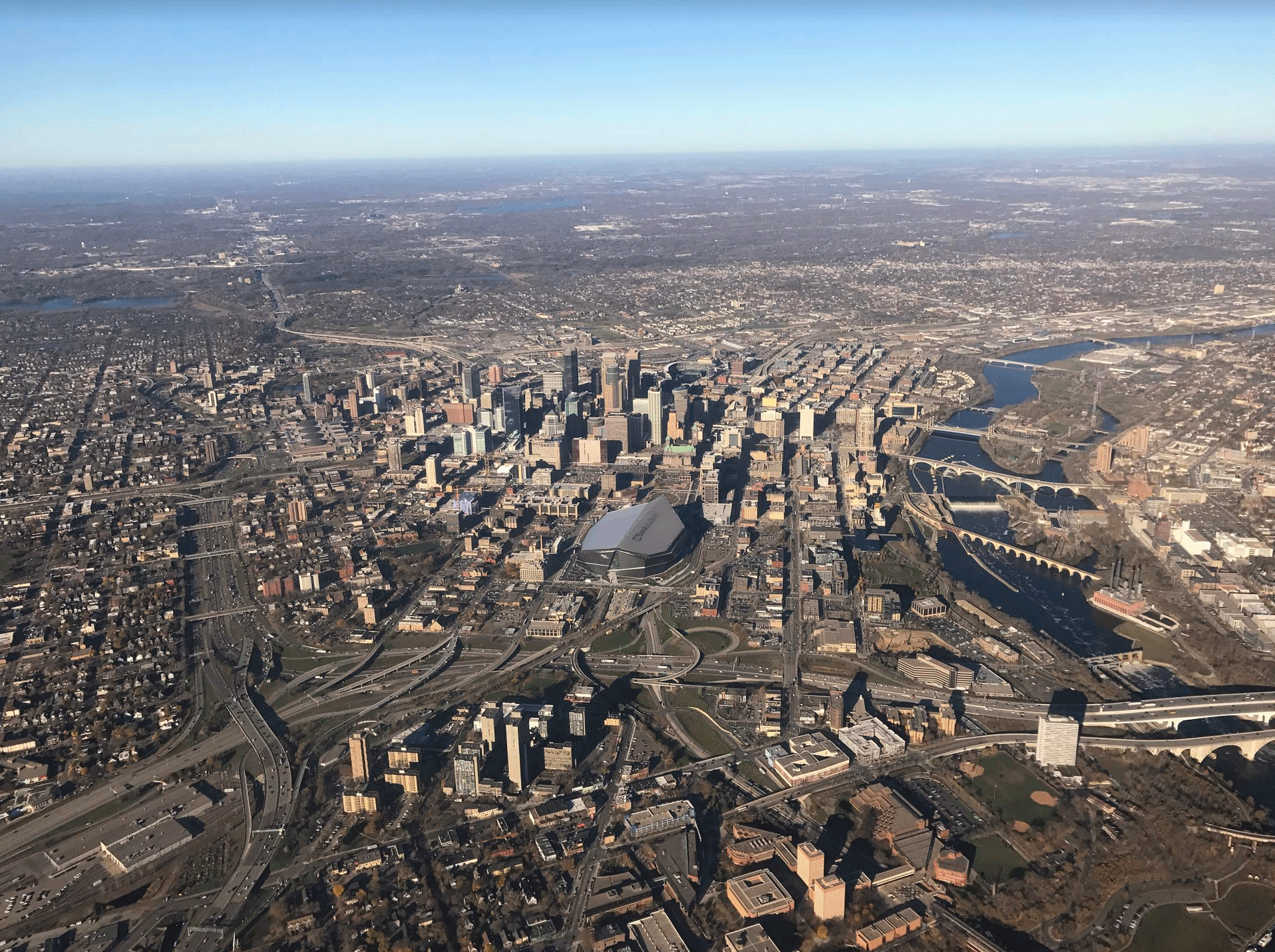
48 F. high in St. Cloud Friday.
42 F. average high on November 11.
51 F. high on November 11, 2015.
November 12, 2000:
A winter storm system produces a narrow band of heavy snow across
extreme western Minnesota. Winds toward the end of the event were
clocked between 15 and 25 mph, resulting in blowing snow leading to
visibilities of 1 to 1.5 miles. Some snow totals included: Canby (Yellow
Medicine County) with 6.5 inches, Madison (Lac Qui Parle County) with
6.0 inches.
November 12, 1940:
Record low highs are set in west central Minnesota. Alexandria records a
high of 8 degrees Fahrenheit, Springfield and Willmar have highs of 10
degrees, and St. Cloud and Minneapolis have highs of 11 degrees.
November 12, 1933: A dust storm hits southwest Minnesota, while a blizzard rages in the northwest part of the state.
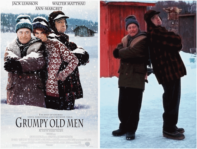
Very Poor Ice Fishing Conditions - More 60s BrewingRemember
Walter Matthau in the movie "Grumpy Old Men"? He and his buddies were
ice fishing in Minnesota around Thanksgiving. When's the last time THAT
happened? At the rate we're going there may be open water into
mid-December.
2016 has seen an 8-month boating season in
Minnesota; from late March into mid-November. "May you live in
interesting times" the Chinese proverb goes. And I don't think that's a
compliment.
According to Dr. Mark Seeley November warmth has been
record-setting, with 36 daily record highs so far. "This is nearly 14F
above normal and surpasses the other warm first 10 days of November
which occurred in 1975, 2001, and 2015" Seeley wrote. Amazing.
A
mild La Nina cool phase in the Pacific may favor a colder, snowier
winter, when it finally arrives, but a warm bias lingers. We should top
60F
Sunday; again
Thursday and
Friday of next week. The arrival of a major, full-latitude trough sparks gusty showers
next Friday, ending as flurries one week from today.
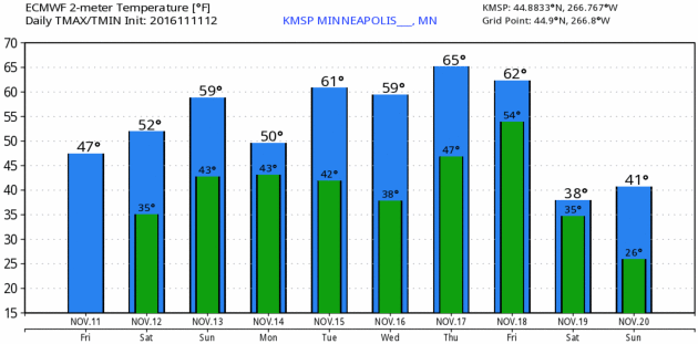
For MSP the first sub-freezing low will come
November 20. That's a whopping
43 days later than average.
 Warmest First 10 Days of November
. So says Dr. Mark Seeley in this week's installment of
Minnesota WeatherTalk: "
The
remarkable warmth so far this month is record-setting. For example in
the Twin Cities, the average temperature for the first ten days of
November is 53.7. This is nearly 14F above normal and surpasses the
other warm first ten days of November which occurred in 1975, 2001, and
2015. This pattern is holding true at a number of locations around the
state, including International Falls where the first ten days of
November are average close to 46F also about 14F above normal. This too
surpasses the other warmest Novembers of 1964, 1975, and 2015. So far
this month 32 daily high temperature records have been set within the
Minnesota Cooperative Weather Observer Network across the state,
including a remarkable reading of 78F at Mora..."
What November?
Temperatures run as much as 20-25F warmer than average into late next
week, before dropping rapidly one week from today; blustery exhaust on
the backside of a significant storm. I wouldn't be surprised to see the
first flurries of fall next Saturday, coming 4-6 weeks later than
average. The first sub-freezing low probably comes next Sunday, November
20, 43 days later than average at MSP, where the average first
32-degree temperature comes October 8. Meteogram: WeatherBell.
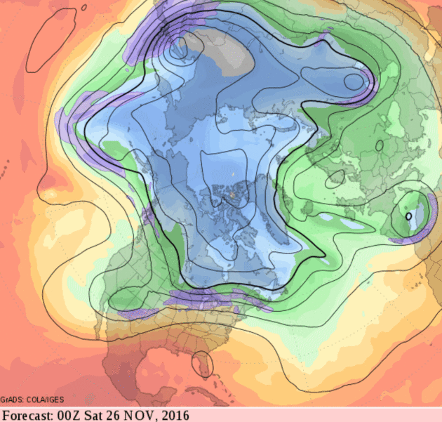
Late Month Swipes of Colder Air - Drought Strengthens Southeastern USA.
Here is the 500mb forecast for Friday evening, November 25, the day
after Thanksgiving, which still looks fairly mild for the eastern half
of the USA.
La Nina Arrives, Likely to Exacerbate Southern Drought. Most (but not all) La Nina cooling phases in the Pacific result in drier winters for the southern USA. Here's an excerpt from
Climate Central: "
La
Niña is here. But unlike the El Niño that preceded it, this climate
event is expected to be weak and short-lived, the National Oceanic and
Atmospheric Administration said
Thursday. But that doesn’t mean the U.S. won’t see some of the typical
impacts of a La Niña; forecasters expect it to tilt the odds in favor of
warmer, drier conditions across the already drought-stricken southern
portions of the country and wetter, cooler conditions across some of the
northern regions. “The weak La Niña is likely to contribute to
persisting or developing drought across much of the southern U.S. this
winter," Mike Halpert, deputy director of NOAA’s Climate Prediction Center, said in a statement..."
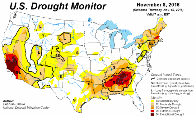
Map credit:
U.S. Drought Monitor.
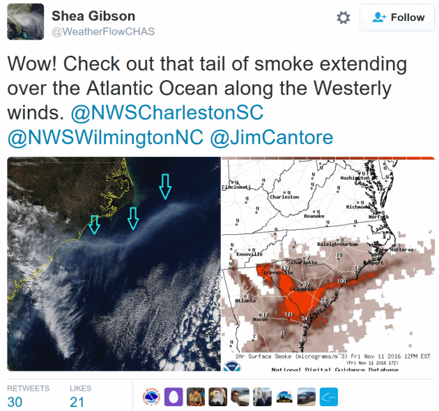
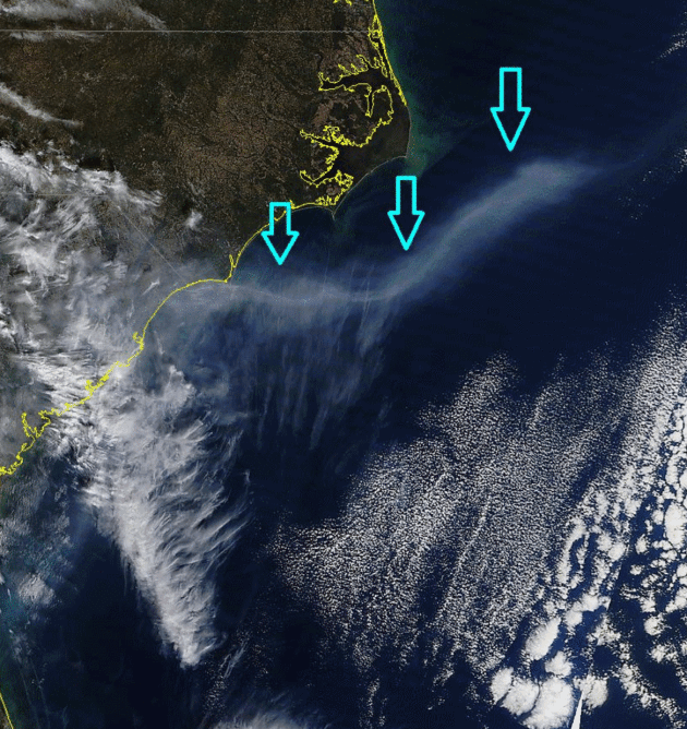
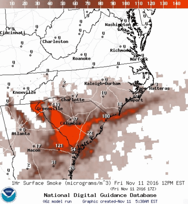
Tracking The Smoke.
7 states are being impacted by severe to extreme drought capable of
generating significant wildfires; the result of very little rain over
the last 2 months.
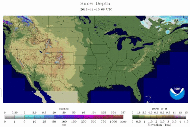
North America is Flooded in Warmth and There Is No Sign of Real Winter. Here's an excerpt of a summary from Jason Samenow at
Capital Weather Gang: "...
Vancouver set a record high just two days before CBC News reported,
and said much of British Columbia had been “extraordinarily warm” in
November. Many areas of Canada which normally have snow at this time of
year have bare ground. As Canada is the source region for cold air over
the Lower 48, it’s no surprise snow is lacking there as well. Snow
covers a mere 0.4 percent of the Lower 48 states — the smallest area on
record for Nov. 10 (dating to 2003). On average, about 10 percent of
the nation has snow on the ground as of this date..."
Map credit:
"U.S. snow cover on Nov. 10, 2016." (NOAA)
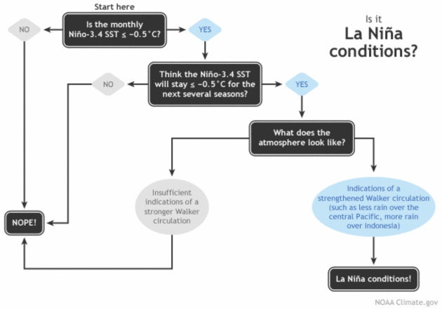
November 2016 La Nina Update: Hello, Lady! Yes, it's official - a (mild) La Nina cooling of equatorial Pacific Ocean water. Here's an excerpt of a post at
NOAA's Climate.gov that explains the conditions that need to be present before it can be (officially) called La Nina: "...
Is the sea surface temperature in the Niño3.4 region more than half a degree cooler than average? Yes!
(It was about -0.7°C below average during October.) Do forecasters
think it will stay cooler than that threshold for several overlapping
three-month periods? Yes!
(But just barely.) Finally, are there signs that the atmospheric
circulation above the tropical Pacific is stronger than average? Yes!
This all means that La Niña has officially arrived..."
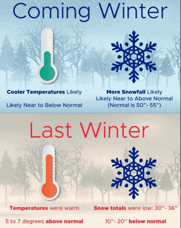
Mild La Nina? Odds Favor Colder and Snowier for Minnesota.
I know, I'll believe it when I see it too. I'm still a bit skeptical
but maybe snow-lovers will be pleasantly surprised this winter.
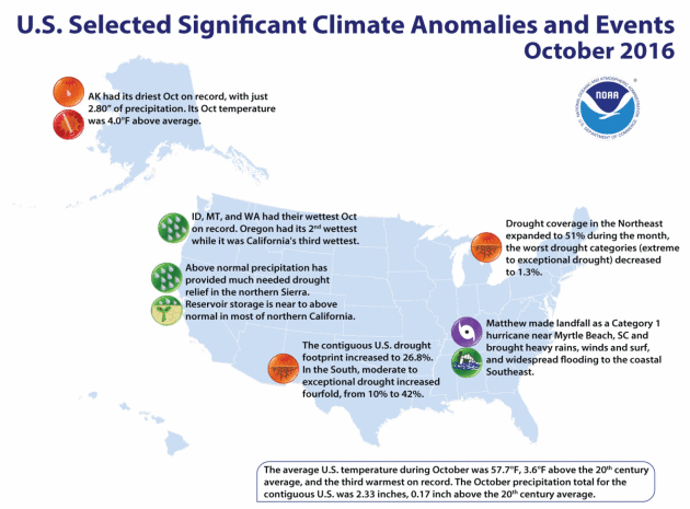
3rd Warmest October for U.S. - On Track For Second Warmest Year To Date. Here are a few highlights from October, courtesy of
NOAA: "...
Other notable climate events in October:
- Drought:
The total area of drought increased from 19.4 percent to 26.8 percent
of the Lower 48, mainly from expansion in the South and Southeast.
- Hurricane Matthew,
a Category 1 hurricane with winds of 75 mph, made landfall in South
Carolina on October 8, causing widespread flooding in the region.
- New Mexico experienced record warmth in October, with an average temperature increase of 5.8 degrees.
- Alaska had its driest October on record.
- Pacific Northwest: Idaho, Montana and Washington each had their wettest October on record, while Oregon experienced its second wettest..."
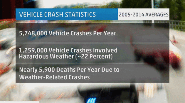
Weather-Related Car Accidents Far More Deadly Than Tornadoes, Hurricanes, Floods. Perspective is important, according to a story at
The Weather Channel: "...
The U.S. Department of Transportation (DOT) says that more than 5,748,000 vehicle crashes occur each year based on statistics from the 10 years spanning 2005-2014.
About 22 percent of those, or close to 1,259,000, involved hazardous
weather. Those U.S. weather-related automobile crashes have killed an
average of nearly 5,900 people annually, accounting for about 16 percent
of all vehicular deaths, the DOT says.
Another 445,000+ were injured each year during that same period of
time. For comparison, the 10-year average combined number of deaths each
year from flooding, lightning, tornadoes, hurricanes, and heat is 375..."
Image credit: "
Annual average vehicle crash statistics." Data from U.S. DOT.
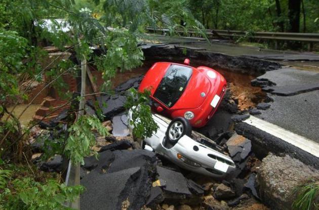
How To Survive Being Caught Up In a Flash Flood.
Most flash flood deaths occur in vehicles, at night, when estimating
water depth is nearly impossible. Here are a few suggestions of what to
do in the unlikely event you ever find your car or truck being
transformed into a boat, courtesy of Times LIVE: "...If
your car is swept into the water and submerged‚ DON'T PANIC! Stay calm
and wait for the vehicle to fill with water. Once the vehicle is full‚
the doors will be able to open. Hold your breath and swim to the
surface. If you are swept into fast moving floodwater outside of your
car‚ point your feet downstream. Always go over obstacles‚ never try to
go under..." (Image credit: Virginia Department of Transportation).
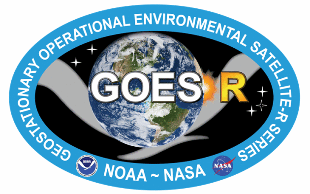
GOES-R Mission. Here's a good explainer of what the next generation of U.S. weather satellites will be able to achieve, courtesy of
NOAA NESDIS: "
The
Geostationary Operational Environmental Satellite-R Series (GOES-R) is
NOAA’s next generation of geostationary weather satellites. The first
satellite in the series, GOES-R, is scheduled for launch on November 16,
2016 at approximately 4:42pm Eastern. Once the satellite reaches
geostationary orbit, it will be known as GOES-16. There will be four
satellites in the series: GOES-R, GOES-S, GOES-T and GOES-U. GOES-R will
provide continuous imagery and atmospheric measurements of Earth’s
Western Hemisphere, total lightning data, and space weather monitoring
to provide critical atmospheric, hydrologic, oceanic, climatic, solar
and space data..."
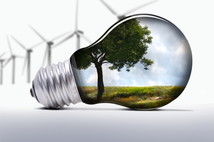
Trump Insider: New Administration Won't Attack Renewable Energy. Here's a clip from a story at
Utility Dive: "...
Energy
is not one of the top five agenda items” on Trump’s to-do list when he
takes office in January, according to a major Trump financial
contributor who said he is a member of the transition team and spoke on
the condition of anonymity. The top issues on that agenda are tax
reform, immigration, reforming health care (Obamacare), infrastructure,
and trade. “Everything with renewables continues; the credits will
remain in place,” he said..."
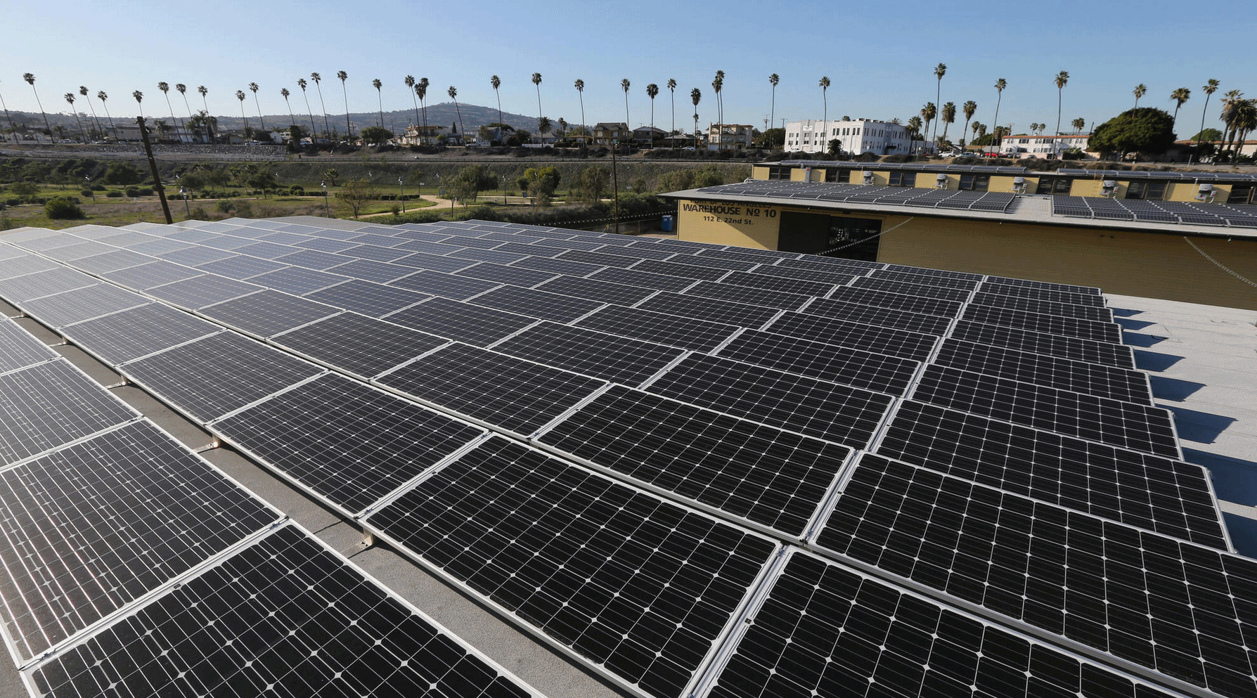 Solar Power Proponents Hopeful Trump Sees Benefit of Growing Industry.
 Here's an excerpt from the
Los Angeles Times: "...
As
part of his larger economic agenda, Trump has proposed lifting
environmental regulations, tapping coal and nuclear power, and opening
federal lands to oil and natural gas production. But despite his
campaign rhetoric, experts and industry players say, Trump’s energy
policies as president will bump into market realities. The challenge
Trump faces is that increasingly the economics in the energy sector
favor renewable technologies such as solar and wind, which are reducing
costs quickly. Increased fracking has produced natural gas at prices
that are cheaper than coal. And a worldwide oil glut has reduced
petroleum profits to the point where reducing regulation and opening
federal lands to drilling is unlikely to bring a drilling boom..."
Photo credit: "
A
large-scale solar panel project sits atop warehouses No. 9 and 10 at
the Port of Los Angeles in San Pedro, which have been converted into
retail space for shops and a microbrewery." (Luis Sinco / Los Angeles Times).
The Tiny Kentucky Town That Eclipse Fans Are Obsessing Over. Interested in hearing more about the total eclipse of the sun next summer? Check out this story at
Atlas Obscura: "
Go ahead. Try to book a hotel room online in Hopkinsville, Kentucky,
for the third weekend in August next summer. You can’t. The rooms
appear to be booked solid from August 19th through August 22th. And the
same goes for hotels and motels in nearby Cadiz, Hardin, Oak Grove, or
any other interchange along Interstate 24. Demand is so high that you
have to personally call to make a reservation, and be willing to pay
between $400 to $800 a night. You could say the stars have aligned for
Hopkinsville. Or, more precisely, the Earth, sun and moon will be
perfected aligned. Next summer will be the first time a total solar
eclipse—when the moon completely blocks out the sun—can be witnessed in
the continental United States since 1979..."
File image: NASA.
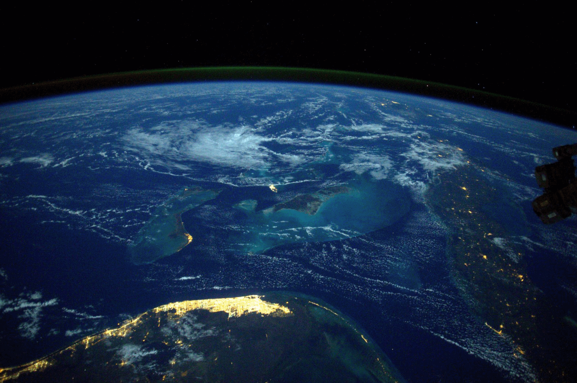 Image Of The Day
.
I came across this image on Twitter, showing Miami and the Bahamas from
the vantagepoint of the International Space Station, courtesy of NASA.
Spectacular.
 The Joys of Pumpkin Spice
.
It's been an interesting week, and nothing calms the nerves like
pumpkin spice...and talking guinea pigs. Thanks to HLN, FLUFF and
YouTube. I predict you're going to like this clip.
 TODAY
TODAY: Sunny, winds increase. Winds: SW 15-25. High: 56
SATURDAY NIGHT: Clear to partly cloudy. Low: 39
SUNDAY: Hello September! Intervals of sunshine. Winds: SW 10-15. High: 62
MONDAY: Bright sun, a bit cooler. Winds: NW 8-13. Wake-up: 43. High: 55
TUESDAY: More clouds, stray sprinkle. Winds: NW 7-12. Wake-up: 41. High: 56
WEDNESDAY: Sunny and pleasant. Winds: E 5-10. Wake-up: 39. High: near 60
THURSDAY: Windy and warm, clouds increase. Winds: S 10-20. Wake-up: 48. High: 68
FRIDAY: Showery, mild start, then colder. Winds: NW 15-30. Wake-up: 56. High: 61, then falling sharply.
Climate Stories
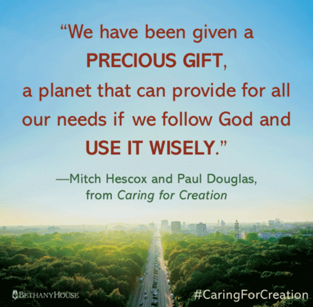
Caring for Creation: Community Conversation and Book Release November 15 at Minnehaha Academy.
If you're interested in this topic (and most everyone should be) I hope
you'll consider coming out next Tuesday evening, November 15, to
Minnehaha Academy to hear co-author of "
Caring for Creation"
Mitch Hescox and me discuss why climate awareness and a push toward
clean energy are essential, and why people of faith should pay attention
to the trends. Going in this direction will save us money, clean up the
air, and prevent our kids and grandkids from having to deal with a
worst-case climate scenario: "
Minnehaha Academy Welcomes
Meteorologist Paul Douglas and Evangelical Environmental Network
Director Mitch Hescox for a Compelling Climate Change Conversation and
Book Release Event. Join us for this not-to-be-missed community
conversation and book release event about climate change and the
Biblical call for Christians to care about the earth.
In this free evening conversation, you’ll learn:
- Why Christians should lead the charge for caring for God’s creation.
- How climate change goes beyond politics and affects the health, economy, and stability of future generations.
- Tips to help your family and those around you care for the earth..."
Record Hot Years Could Be The "New Normal" by 2025. So reports
Huffington Post: "
Following in the blistering footsteps of 2014 and 2015, this year is on track
to be the warmest on record. And we probably need to get accustomed to
this sweltering heat. If carbon emissions continue to rise at their
current rate, these record hot years will be the “new normal” by 2025, new research shows. Even if we take action to curb emissions, the damage has already been done, warns the study, published Friday in the Bulletin of American Meteorological Society. Human activities have already ensured that the global annual average temperature of 2015 will be the norm “no later than 2040,” the researchers said..."
Michael Bloomberg Has a Plan To Shift The Conversation on Climate Change.
Business Insider reports: "...
Bloomberg
and Pope firmly believe that fixing those flaws will allow the entire
global economy to grow. When they researched current technologies and
initiatives that could address some of the biggest environmental
problems, Pope says they “found that each one had a pretty attractive
set of solutions and that collectively, solving climate will make a lot
of money for the world.” That wasn’t true 20 years ago, when solar and
wind power were vastly more expensive, electric cars were not yet a
reality, it was difficult to monitor and track illegal deforestation,
and far less was known about how to make agriculture more sustainable.
The world’s approach, according to Bloomberg and Pope, is still stuck in
that era..."
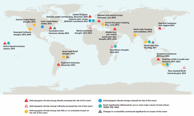
Growing Link Between Global Warming & Extreme Weather, Finds World Meteorological Organization. A warmer, wetter atmosphere is turning up the volume on extreme weather, especially record heat and flooding rains.
Clean Technica connects the dots related to attribution: "...
The new report, The Global Climate 2011-2015, investigated
the warmest five-year period on record, 2011 to 2015, which was also
the warmest on record for every single continent except Africa. These
record temperatures were accompanied by rising sea levels, as well as
major declines in Arctic sea-ice extent, continental glaciers, and
northern hemisphere snow cover. As the World Meteorological Organization
(WMO) notes, “All these climate change indicators confirmed the
long-term warming trend caused by greenhouse gases.” The WMO also points
to the awkwardly historic milestone, which we reported back in June, that carbon dioxide levels surpassed 400 parts per million for the first time in 4 million years..."
Map credit: "
Results of studies on attribution of extreme events to anthropogenic climate change." (Sources: Bulletin of the American Meteorological Society and various other publications)
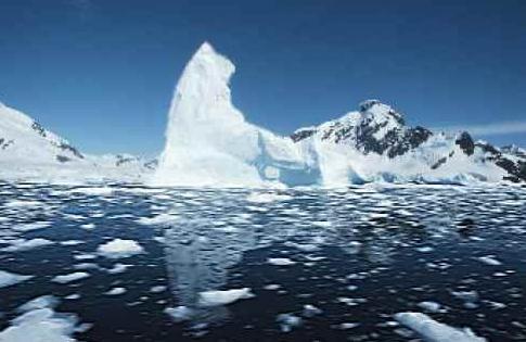
How To Tell When The Arctic Ocean Will Be Ice Free. Here's a clip from a story at
Pacific Standard: "...
The
estimates also suggests, based on current sea-ice coverage, that it
will take another trillion metric tons of carbon dioxide emissions
before Arctic summer sea ice more or less vanishes. Given global
greenhouse gas emissions of around 35 trillion metric tons per year,
that suggests there won’t be any Arctic sea ice in September by
mid-century."


No comments:
Post a Comment