58 F. maximum temperature yesterday in St. Cloud.
39 F. average high on November 15.
58 F. high in the STC metro on November 15, 2015.
November 16, 1931: A tornado touches down near Maple Plain in Hennepin County. The tornado damage path was five miles long.
An Atmospheric Version of Beauty and the Beast
It's quite remarkable: people waving at me - with all their fingers! Some have stopped me on the street and thanked me for our jumbo, super-sized autumn. No, it's not at all unusual to be mowing your lawn in Minnesota in mid-November. No need to be concerned, please move along!
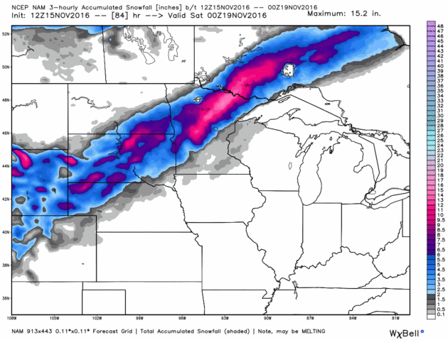
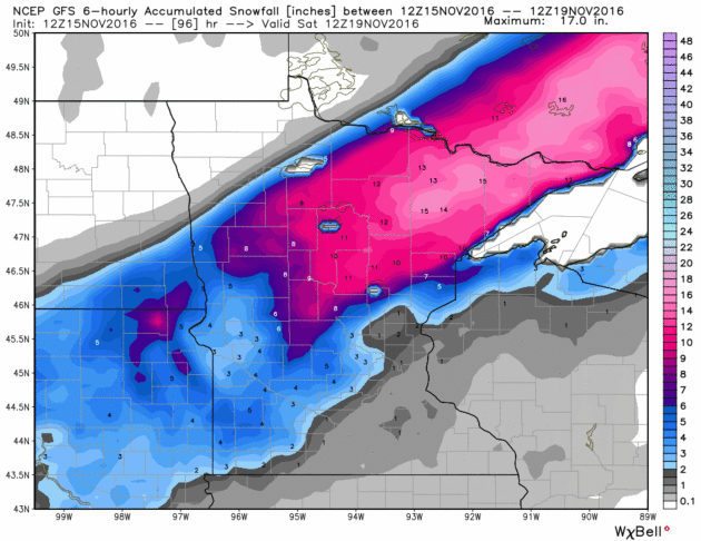
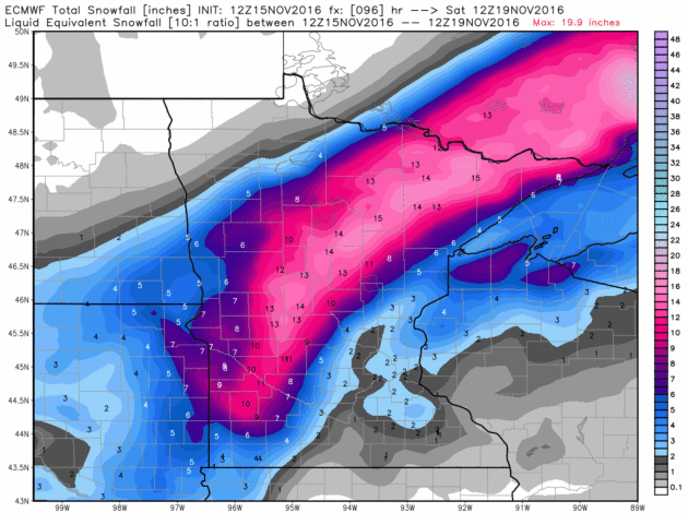
Considering we could be butt-deep in snow I don't take 60F and sunshine for granted. Mild weather lingers into early Friday, and then temperatures go over a small cliff. Models suggest a big storm tracking from Wichita to Des Moines to Eau Claire on Friday, sucking enough cold air into Minnesota for a changeover to heavy wet snow. Ground temperatures are still mild, so some of that snow will melt on contact in the metro area, but an inch or two of slush can't be ruled out on lawns and fields by Friday night.
As much as 5-12 inches of wet snow may fall from Alexandria to the Brainerd Lakes and Minnesota Arrowhead during the PM hours Friday. Like turning on a light switch: instant winter.
Travel improves over the weekend and Thanksgiving week brings highs in the 40s; a cold rain next Wednesday.
Could be worse.
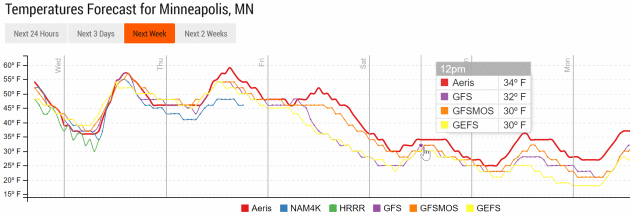
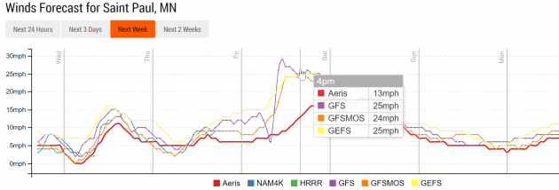
Meteograms above showing high winds and rapidly falling temperatures on Friday courtesy of NOAA and AerisWeather.

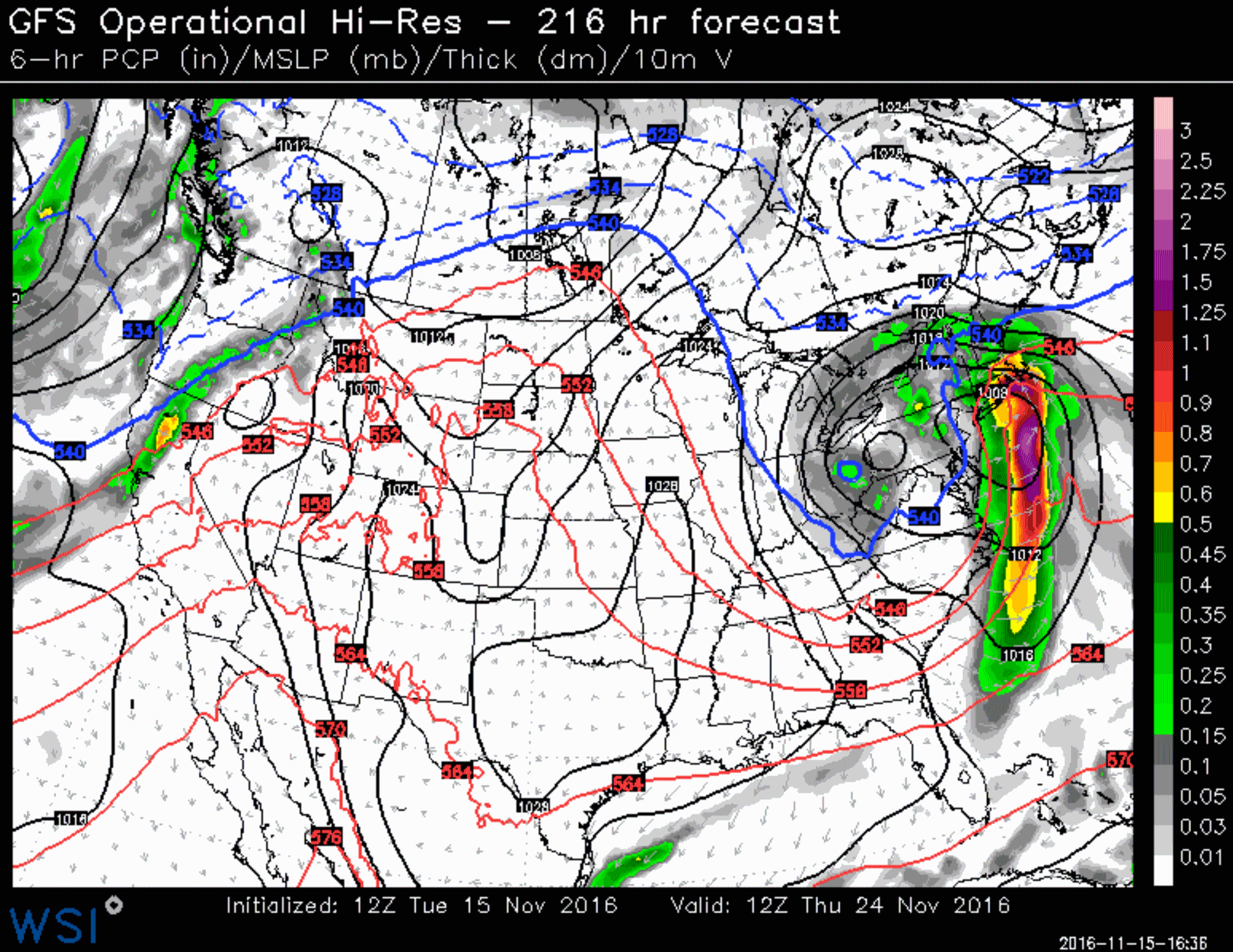
Thanksgiving Day: GFS Solution. NOAA's GFS model pulls a surge of moderate to heavy rain into New England next Thursday, with wrap-around showers of rain and snow for Pennsylvania and Ohio. Showers are forecast to push into northern California; otherwise the rest of the USA looks relatively quiet and fairly mild from the Great Plains into the southwestern states. Source: WSI.
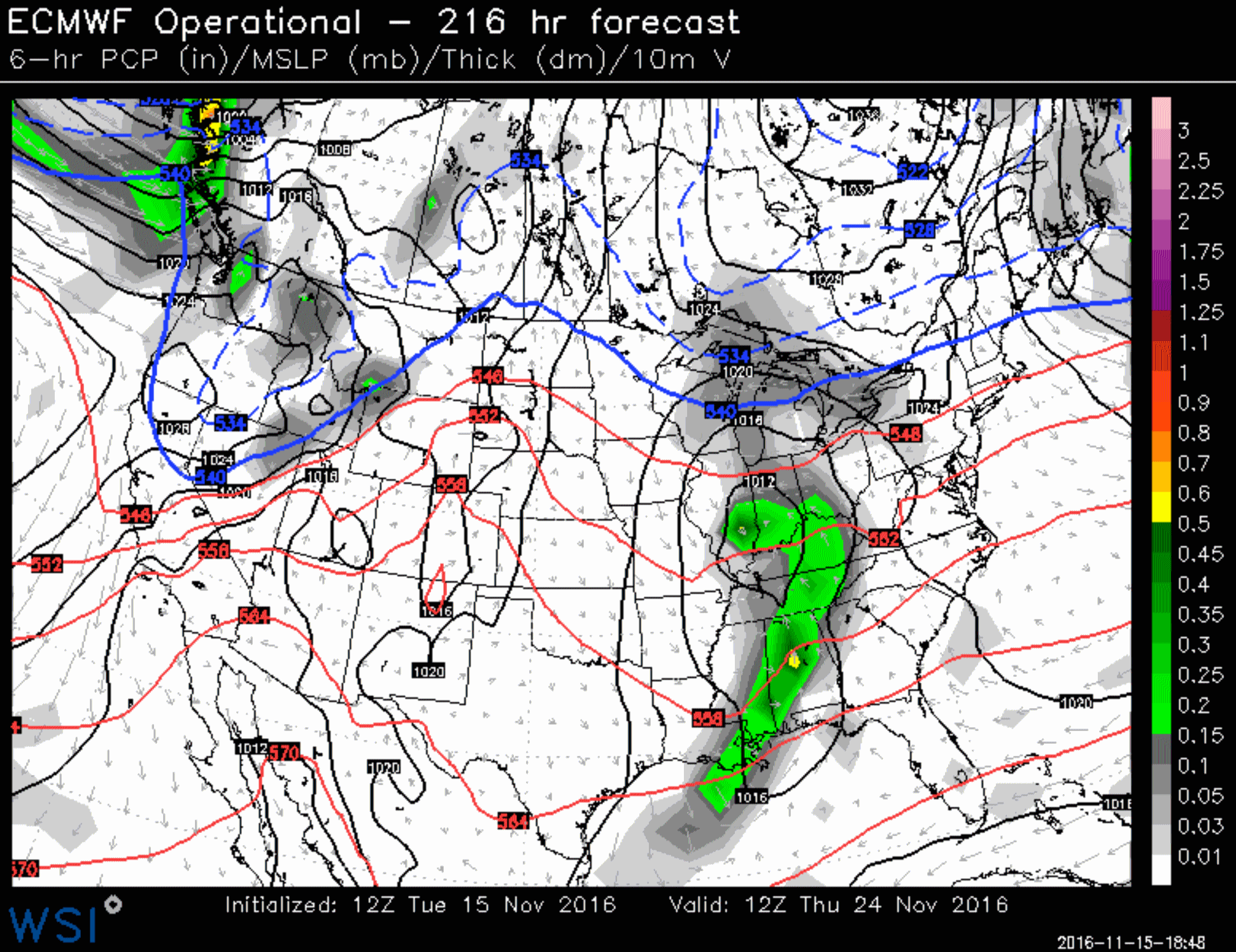
Thanksgiving Day: ECMWF Solution. I look at all the models but if push comes to shove I still assign more weight to the European. It's far from perfect or foolproof, but it often does a better job, especially beyond 5 days. The ECMWF suggests (rain) showers Thanksgiving Day from the Ohio Valley to the Gulf Coast; showery, unsettled weather for the Pacific Northwest - otherwise most of America gets a break this year.
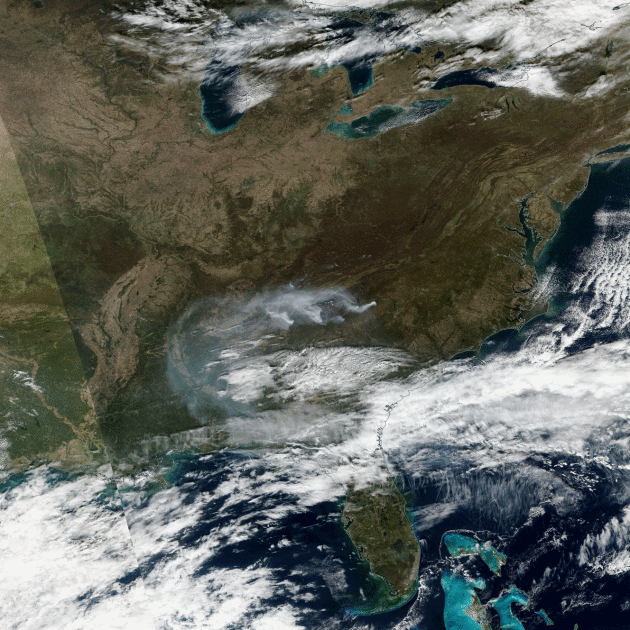
Image credit: "Plumes of smoke from wildfires burning in the southern Appalachians are seen in this broad view of nearly half of the United States acquired by the Suomi NPP satellite on November 12, 2016. The smoke plumes are roughly dead center in the image, almost straight north from Florida. Click on the image and then click again for extreme closeup views." (Source: NASA Worldview).
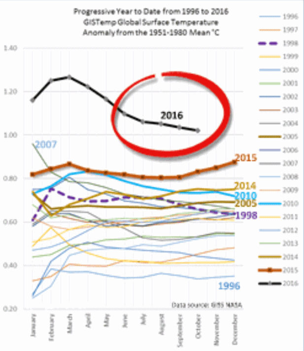
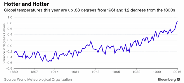
2016 Likely To Top 2015 As Hottest Year On Record, Scientists Say. Here's an excerpt from The New York Times: "...The
meteorological organization found that global temperatures from January
to September were about 0.88 degrees Celsius (1.58 degrees Fahrenheit)
above the average for the years from 1961 to 1990, a period the
organization uses as a baseline. Temperatures spiked early this year
because of the weather phenomenon known as El Niño, which exacerbated
coral reef bleaching, which is caused by water that is too warm, and a
rise in sea levels. “Preliminary data for October indicate that they are
at a sufficiently high level for 2016 to remain on track for the title
of hottest year on record,” the organization said. That would mean that
16 of the 17 hottest years on record have been in the 21st century. The
other one was 1998..."
Interactive data for 2015 courtesy of The New York Times.
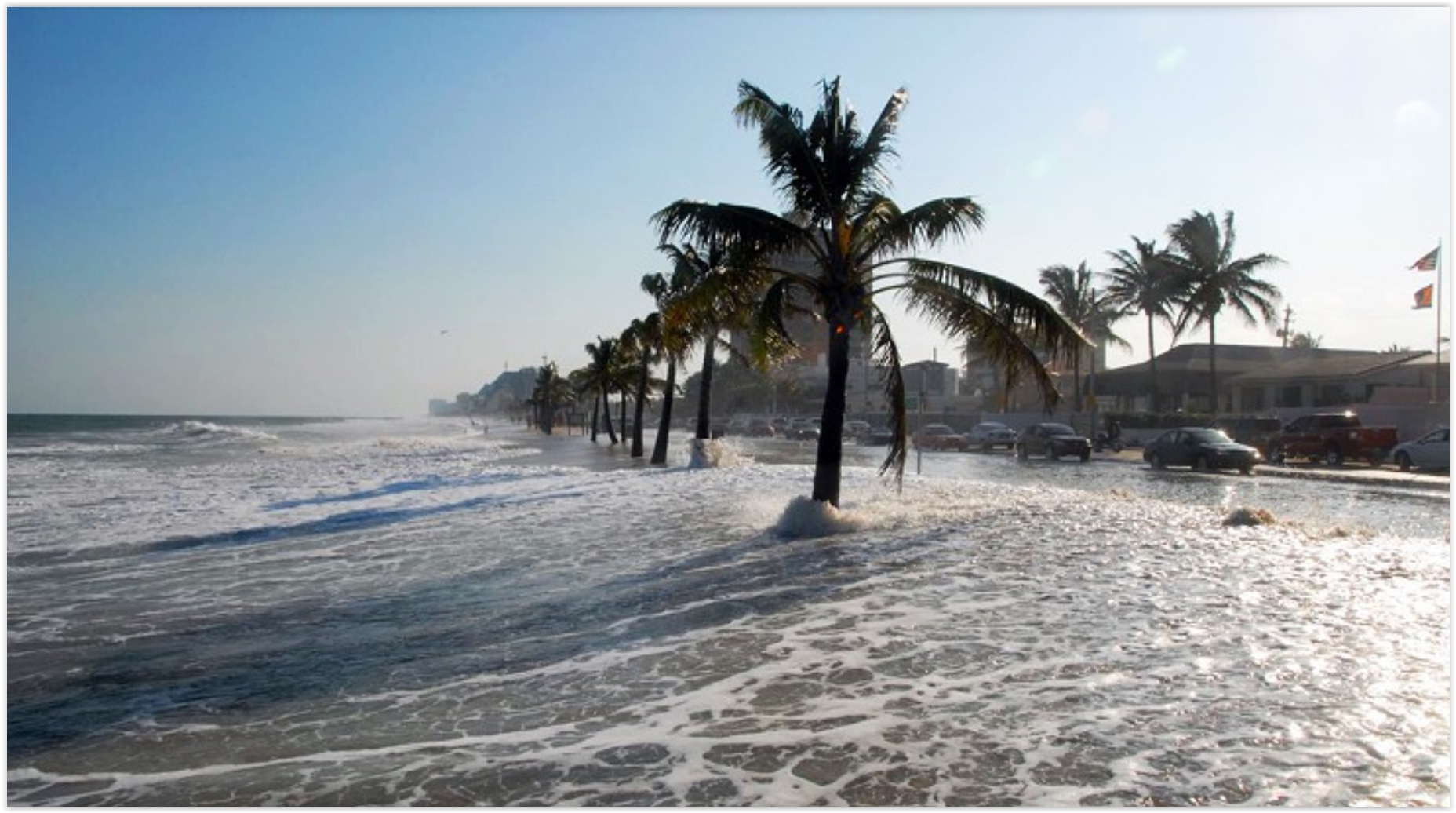
Will Rising Sea Levels Sink Property Values? Here's an excerpt from Yahoo! Finance: "...But
many people don’t realize that investing in waterfront property now may
lose them money, in much the same way as splurging on an expensive car
would: depreciation. The reason? Rising sea levels are eroding the
long-term value of such properties. “Once impacts become noticeable,
they’re going to be upon you quickly,” William V. Sweet, a scientist
with the National Oceanic and Atmospheric Administration in Silver
Spring, Maryland, told The New York Times.
“It’s not a hundred years off — it’s now.” Sea levels are rising,
according to scientists, due to global warming, as rising atmospheric
and ocean temperatures melt polar ice caps and glaciers. Even skeptics
of the phenomenon may find it difficult to argue with the “sharp jump in
this nuisance flooding,” currently impacting the East Coast and Gulf
Coast. Expect more flooding in those areas and the West Coast, too,
according to The Times report..."
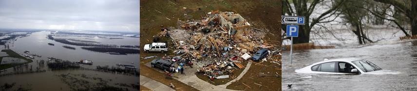
Natural Disasters Push 26 Million Into Poverty Each Year, Says World Bank. The Guardian reports: "Floods, earthquakes, tsunamis and other extreme natural disasters push 26 million people into poverty each year and cost the global economy more than half a trillion dollars in lost consumption, the World Bank has said. A bank study of 117 countries concluded that the full cost of natural disasters was $520bn (£416bn) a year – 60% higher than any previous estimate – once the impact on poor people was taken into account..."
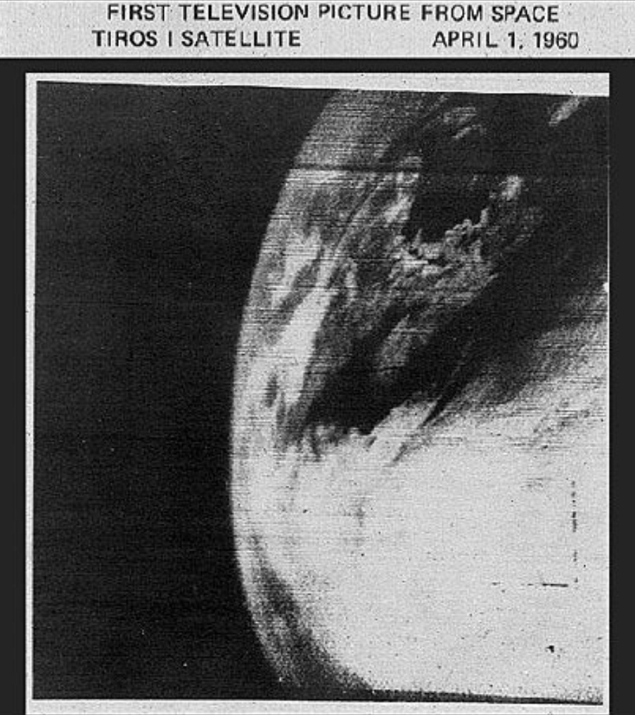
The History of Weather Satellites. AccuWeather has an interesting post - yes, we've come a long way, and GOES-R marks the next big evolutionary leap: "The science of weather forecasting has come a long way over the past 100 years, but one of the biggest leaps forward occurred once information from weather satellites was readily available. Weather satellites have had such a huge impact on weather forecasting that some divide the history of meteorology into two categories: pre-satellite era and post-satellite era. Weather satellites provide invaluable data to meteorologists all around the world, not only by sending forecasters images of weather systems but also by supplying weather models with remote observations in places where observations cannot be taken at the Earth's surface..."
Image credit: "The first photo of Earth from a weather satellite, taken by TIROS-1." (Photo/NASA)
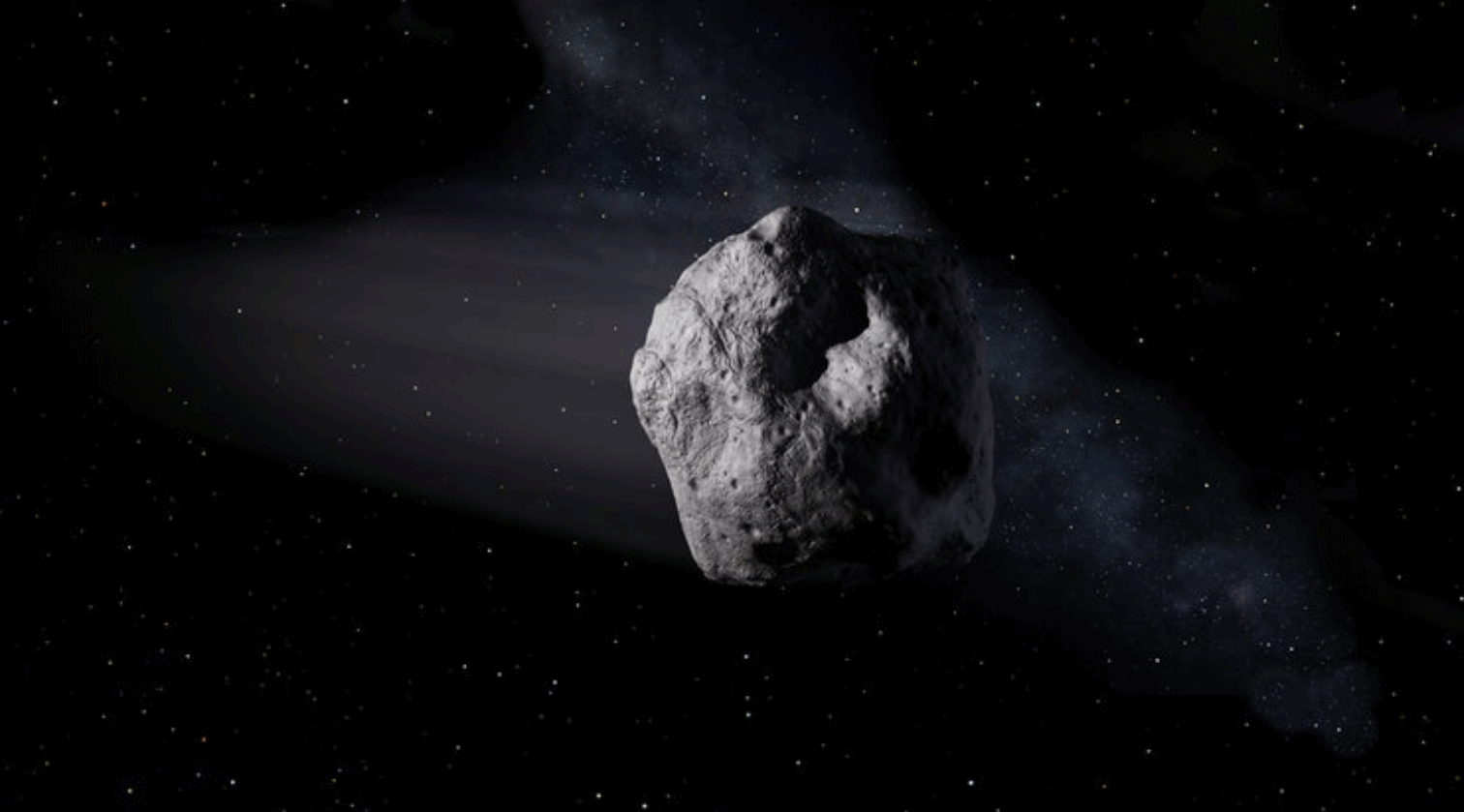
NASA and FEMA Rehearse For The Unthinkable: An Asteroid Strike on Los Angeles.
No, don't sweat La Nina, in light of the (theoretical) 330 foot wide
asteroid heading toward LAX. It's not real, not yet, but federal
agenices are war-gaming what would happen if it was the real deal. The New York Times reports: "Imagine
if scientists discovered that an asteroid was hurtling toward Los
Angeles. The possibility has existed on the pages of Hollywood scripts.
But in what may be a case of life imitating art, NASA, the Federal Emergency Management Agency
and other government agencies engaged last month in a planetary
protection exercise to consider the potentially devastating consequences
of a 330-foot asteroid hitting the Earth.
The simulation projected a worst-case blast wave by an asteroid strike
in 2020 that could level structures across 30 miles, require a mass
evacuation of the Los Angeles area and cause tens of thousands of
casualties..."
Image credit: "An artist’s concept of a near-Earth object." Credit JPL-Caltech/NASA.

Photo credit: "Fueling manager Jarid Svraka looks on as he fuels an Alaska Airlines Boeing 737-800 jet with a new, blended alternative jet fuel Monday at Seattle-Tacoma International Airport. The fuel contains 20 percent biofuel made from forest residuals." (Elaine Thompson/AP)

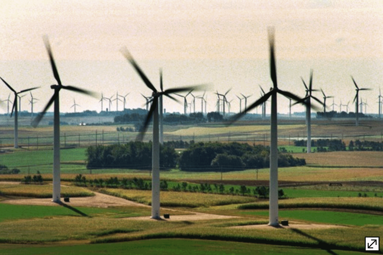
St. Olaf Embraces Wind Power - 100% Star Tribune has the details: "St.
Olaf College's many dozens of buildings on its Northfield campus are
now being powered entirely by wind energy, the liberal arts school and
Xcel Energy announced Monday. By choosing Xcel's Windsource program for
its electrical service starting at the beginning of this semester, St.
Olaf becomes the utility's largest Windsource customer in the state..."
Photo credit: "Part of the Buffalo Ridge complex of wind turbines in Ruthton, Minn." Star Tribune.

TODAY: Partly sunny, mild. Winds: SE 10-15. High: 57
WEDNESDAY NIGHT: Patchy clouds, abnormally warm night for mid-November. Low: 49
THURSDAY: Clouds increase and thicken, no travel headaches yet. Winds: E 7-12. High: 61
FRIDAY: Falling temps, blustery. Rain changes to snow. Slushy potential PM hours. Winds: NW 20-40. High: 52 (falling into the 30s by late afternoon)
SATURDAY: Sun peeks out, winds ease. Winds: NW 10-20. Chilly. Wake-up: 32. High: 37
SUNDAY: First hard freeze for MSP. Bright sunshine. Winds: E 5-10. Wake-up: 26. High: 36
MONDAY: Clouds slowly increase. Winds: SE 10-15. Wake-up: 28. High: near 40
TUESDAY: Mostly cloudy, feels like November. Winds: SE 8-13. Wake-up: 30. High: 42
Climate Stories
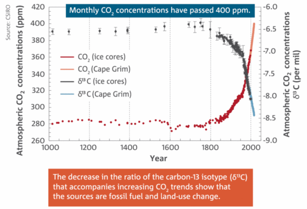
Graphic credit: "Cape Grim has documented the increase in atmospheric CO2 concentrations." CSIRO/Bureau of Meteorology, Author provided.

Image credit: Elena Scotti/FUSION.

Religious Environmentalists Gird Themselves for a Trump Presidency. Here's the intro to a story at Religion News Service: "For environmentalists who ground their work in faith, Donald Trump in the White House presents an unexpected and direct challenge to what they consider their God-given responsibility to care for Creation. And they fear that of all the changes a Trump presidency will bring, his dismissal of climate change could be the most far-reaching and damaging. Trump has deemed climate change a “hoax.” He said he wants to ignore the Paris climate accords. And he has indicated that he would roll back President Obama’s efforts to reduce methane, carbon and other pollutants..." (Image credit: NASA).
No comments:
Post a Comment